Data access and discovery#
Context#
We will be using Long Term Statistics (1999-2019) product provided by the Copernicus Global Land Service over Lombardia and access them through S3-compatible storage. We will also explore Sentinel-2 Cloud-Optimised Dataset online through SpatioTemporal Asset Catalogs (STAC).
Setup#
This episode uses the following main Python packages:
s3fs [S3FsDTeam16]
pystac-client [pystacDTeam24]
odc-stac [ODCDTeam24]
rioxarray [SBR+22]
matplotlib [Hun07]
cartopy [MetOffice15]
Please install these packages if not already available in your Python environment.
Packages#
In this episode, Python packages are imported when we start to use them. However, for best software practices, we recommend you to install and import all the necessary libraries at the top of your Jupyter notebook.
Introduction to the Long Term statistics#
CGLS LTS are computed over a time span of 20 years aggregated over separate 10-day periods (month/01,month/11, month/21). For each date the long term minimum, maximum, mean, median and standard deviation are computed.
S3-compatible Object Storage to access online data#
Up to now we have downloaded data locally and then opened with Xarray open_dataset. When willing to manipulate large amount of data, this approach is not optimal (since it requires a lot of unnecessary local downloads). Sharing data online as Object Storage allows for data sharing and access to much larger amounts of data.
One of the most popular methods to access online remote data is through Amazon Simple Storage Service (S3) and you don’t necessarily need to use Amazon services to benefit from S3 object storage. Many other providers offer S3-compatible object storage that can be accessed in a very similar way.
Below we will be accessing online the NDVI Long Term Statistics from Copernicus Land Service that we have publicly stored in OpenStack Object storage (Swift).
import s3fs
import xarray as xr
fs = s3fs.S3FileSystem(anon=True,
      client_kwargs={
         'endpoint_url': 'https://object-store.cloud.muni.cz'
      })
Tip
The parameter anon is for anonymous and is set to True because the data we have stored at https://object-store.cloud.muni.cz is public
List files and folders in existing buckets#
Instead of organizing files in various folders, object storage systems store files in a flat organization of containers (called “buckets”).
fs.ls('foss4g-data')
['foss4g-data/CGLS_LTS_1999_2019',
 'foss4g-data/CGLS_LTS_1999_2019_Lombardia',
 'foss4g-data/test']
fs.ls('foss4g-data/CGLS_LTS_1999_2019_Lombardia')
['foss4g-data/CGLS_LTS_1999_2019_Lombardia/',
 'foss4g-data/CGLS_LTS_1999_2019_Lombardia/AOI_c_gls_NDVI-LTS_1999-2019-0101_GLOBE_VGT-PROBAV_V3.0.1.nc',
 'foss4g-data/CGLS_LTS_1999_2019_Lombardia/AOI_c_gls_NDVI-LTS_1999-2019-0111_GLOBE_VGT-PROBAV_V3.0.1.nc',
 'foss4g-data/CGLS_LTS_1999_2019_Lombardia/AOI_c_gls_NDVI-LTS_1999-2019-0121_GLOBE_VGT-PROBAV_V3.0.1.nc',
 'foss4g-data/CGLS_LTS_1999_2019_Lombardia/AOI_c_gls_NDVI-LTS_1999-2019-0201_GLOBE_VGT-PROBAV_V3.0.1.nc',
 'foss4g-data/CGLS_LTS_1999_2019_Lombardia/AOI_c_gls_NDVI-LTS_1999-2019-0211_GLOBE_VGT-PROBAV_V3.0.1.nc',
 'foss4g-data/CGLS_LTS_1999_2019_Lombardia/AOI_c_gls_NDVI-LTS_1999-2019-0221_GLOBE_VGT-PROBAV_V3.0.1.nc',
 'foss4g-data/CGLS_LTS_1999_2019_Lombardia/AOI_c_gls_NDVI-LTS_1999-2019-0301_GLOBE_VGT-PROBAV_V3.0.1.nc',
 'foss4g-data/CGLS_LTS_1999_2019_Lombardia/AOI_c_gls_NDVI-LTS_1999-2019-0311_GLOBE_VGT-PROBAV_V3.0.1.nc',
 'foss4g-data/CGLS_LTS_1999_2019_Lombardia/AOI_c_gls_NDVI-LTS_1999-2019-0321_GLOBE_VGT-PROBAV_V3.0.1.nc',
 'foss4g-data/CGLS_LTS_1999_2019_Lombardia/AOI_c_gls_NDVI-LTS_1999-2019-0401_GLOBE_VGT-PROBAV_V3.0.1.nc',
 'foss4g-data/CGLS_LTS_1999_2019_Lombardia/AOI_c_gls_NDVI-LTS_1999-2019-0411_GLOBE_VGT-PROBAV_V3.0.1.nc',
 'foss4g-data/CGLS_LTS_1999_2019_Lombardia/AOI_c_gls_NDVI-LTS_1999-2019-0421_GLOBE_VGT-PROBAV_V3.0.1.nc',
 'foss4g-data/CGLS_LTS_1999_2019_Lombardia/AOI_c_gls_NDVI-LTS_1999-2019-0501_GLOBE_VGT-PROBAV_V3.0.1.nc',
 'foss4g-data/CGLS_LTS_1999_2019_Lombardia/AOI_c_gls_NDVI-LTS_1999-2019-0511_GLOBE_VGT-PROBAV_V3.0.1.nc',
 'foss4g-data/CGLS_LTS_1999_2019_Lombardia/AOI_c_gls_NDVI-LTS_1999-2019-0521_GLOBE_VGT-PROBAV_V3.0.1.nc',
 'foss4g-data/CGLS_LTS_1999_2019_Lombardia/AOI_c_gls_NDVI-LTS_1999-2019-0601_GLOBE_VGT-PROBAV_V3.0.1.nc',
 'foss4g-data/CGLS_LTS_1999_2019_Lombardia/AOI_c_gls_NDVI-LTS_1999-2019-0611_GLOBE_VGT-PROBAV_V3.0.1.nc',
 'foss4g-data/CGLS_LTS_1999_2019_Lombardia/AOI_c_gls_NDVI-LTS_1999-2019-0621_GLOBE_VGT-PROBAV_V3.0.1.nc',
 'foss4g-data/CGLS_LTS_1999_2019_Lombardia/AOI_c_gls_NDVI-LTS_1999-2019-0701_GLOBE_VGT-PROBAV_V3.0.1.nc',
 'foss4g-data/CGLS_LTS_1999_2019_Lombardia/AOI_c_gls_NDVI-LTS_1999-2019-0711_GLOBE_VGT-PROBAV_V3.0.1.nc',
 'foss4g-data/CGLS_LTS_1999_2019_Lombardia/AOI_c_gls_NDVI-LTS_1999-2019-0721_GLOBE_VGT-PROBAV_V3.0.1.nc',
 'foss4g-data/CGLS_LTS_1999_2019_Lombardia/AOI_c_gls_NDVI-LTS_1999-2019-0801_GLOBE_VGT-PROBAV_V3.0.1.nc',
 'foss4g-data/CGLS_LTS_1999_2019_Lombardia/AOI_c_gls_NDVI-LTS_1999-2019-0811_GLOBE_VGT-PROBAV_V3.0.1.nc',
 'foss4g-data/CGLS_LTS_1999_2019_Lombardia/AOI_c_gls_NDVI-LTS_1999-2019-0821_GLOBE_VGT-PROBAV_V3.0.1.nc',
 'foss4g-data/CGLS_LTS_1999_2019_Lombardia/AOI_c_gls_NDVI-LTS_1999-2019-0901_GLOBE_VGT-PROBAV_V3.0.1.nc',
 'foss4g-data/CGLS_LTS_1999_2019_Lombardia/AOI_c_gls_NDVI-LTS_1999-2019-0911_GLOBE_VGT-PROBAV_V3.0.1.nc',
 'foss4g-data/CGLS_LTS_1999_2019_Lombardia/AOI_c_gls_NDVI-LTS_1999-2019-0921_GLOBE_VGT-PROBAV_V3.0.1.nc',
 'foss4g-data/CGLS_LTS_1999_2019_Lombardia/AOI_c_gls_NDVI-LTS_1999-2019-1001_GLOBE_VGT-PROBAV_V3.0.1.nc',
 'foss4g-data/CGLS_LTS_1999_2019_Lombardia/AOI_c_gls_NDVI-LTS_1999-2019-1011_GLOBE_VGT-PROBAV_V3.0.1.nc',
 'foss4g-data/CGLS_LTS_1999_2019_Lombardia/AOI_c_gls_NDVI-LTS_1999-2019-1021_GLOBE_VGT-PROBAV_V3.0.1.nc',
 'foss4g-data/CGLS_LTS_1999_2019_Lombardia/AOI_c_gls_NDVI-LTS_1999-2019-1101_GLOBE_VGT-PROBAV_V3.0.1.nc',
 'foss4g-data/CGLS_LTS_1999_2019_Lombardia/AOI_c_gls_NDVI-LTS_1999-2019-1111_GLOBE_VGT-PROBAV_V3.0.1.nc',
 'foss4g-data/CGLS_LTS_1999_2019_Lombardia/AOI_c_gls_NDVI-LTS_1999-2019-1121_GLOBE_VGT-PROBAV_V3.0.1.nc',
 'foss4g-data/CGLS_LTS_1999_2019_Lombardia/AOI_c_gls_NDVI-LTS_1999-2019-1201_GLOBE_VGT-PROBAV_V3.0.1.nc',
 'foss4g-data/CGLS_LTS_1999_2019_Lombardia/AOI_c_gls_NDVI-LTS_1999-2019-1211_GLOBE_VGT-PROBAV_V3.0.1.nc',
 'foss4g-data/CGLS_LTS_1999_2019_Lombardia/AOI_c_gls_NDVI-LTS_1999-2019-1221_GLOBE_VGT-PROBAV_V3.0.1.nc']
Access remote files from S3-compatible Object Storage#
s3path = 's3://foss4g-data/CGLS_LTS_1999_2019_Lombardia/AOI_c_gls_NDVI-LTS_1999-2019-0101_GLOBE_VGT-PROBAV_V3.0.1.nc'
LTS = xr.open_dataset(fs.open(s3path))
LTS
<xarray.Dataset> Size: 3MB
Dimensions:  (lon: 331, lat: 235)
Coordinates:
  * lon      (lon) float64 3kB 8.5 8.509 8.518 8.527 ... 11.42 11.43 11.44 11.45
  * lat      (lat) float64 2kB 46.7 46.69 46.68 46.67 ... 44.63 44.62 44.61
Data variables:
    crs      |S1 1B ...
    min      (lat, lon) float64 622kB ...
    median   (lat, lon) float64 622kB ...
    max      (lat, lon) float64 622kB ...
    mean     (lat, lon) float64 622kB ...
    stdev    (lat, lon) float64 622kB ...
    nobs     (lat, lon) float32 311kB ...
Attributes: (12/19)
    Conventions:          CF-1.6
    parent_identifier:    urn:cgls:global:ndvi_stats_all
    identifier:           urn:cgls:global:ndvi_stats_all:NDVI-LTS_1999-2019-0...
    long_name:            Normalized Difference Vegetation Index
    title:                Normalized Difference Vegetation Index: Long Term S...
    product_version:      V3.0.1
    ...                   ...
    source:               Derived from EO satellite imagery
    processing_mode:      Offline
    references:           https://land.copernicus.eu/global/products/ndvi
    copyright:            Copernicus Service information 2021
    archive_facility:     VITO
history: 2021-03-01 - Processing line NDVI LTSLTS.sel(lat=45.88, lon=8.63, method='nearest')['min'].values
array(0.264)
Warning
The same dataset can be available from different locations e.g. CGLS distributor VITO, Zenodo, S3-compatible OpenStack Object storage (Swift), etc. How do you know if it corresponds to the very same dataset? You cannot know except if the datasets have a persistent identifier such as a Digital Object Identifier. It is therefore recommended 1) to be extra careful about where you get your datasets, and 2) to double check that the content is exactly what you expect (for instance, you can perform basic quality checks).
Access multiple remote files#
s3path = 's3://foss4g-data/CGLS_LTS_1999_2019_Lombardia/AOI_c_gls_*.nc'
remote_files = fs.glob(s3path)
remote_files
Show code cell output
['foss4g-data/CGLS_LTS_1999_2019_Lombardia/AOI_c_gls_NDVI-LTS_1999-2019-0101_GLOBE_VGT-PROBAV_V3.0.1.nc',
 'foss4g-data/CGLS_LTS_1999_2019_Lombardia/AOI_c_gls_NDVI-LTS_1999-2019-0111_GLOBE_VGT-PROBAV_V3.0.1.nc',
 'foss4g-data/CGLS_LTS_1999_2019_Lombardia/AOI_c_gls_NDVI-LTS_1999-2019-0121_GLOBE_VGT-PROBAV_V3.0.1.nc',
 'foss4g-data/CGLS_LTS_1999_2019_Lombardia/AOI_c_gls_NDVI-LTS_1999-2019-0201_GLOBE_VGT-PROBAV_V3.0.1.nc',
 'foss4g-data/CGLS_LTS_1999_2019_Lombardia/AOI_c_gls_NDVI-LTS_1999-2019-0211_GLOBE_VGT-PROBAV_V3.0.1.nc',
 'foss4g-data/CGLS_LTS_1999_2019_Lombardia/AOI_c_gls_NDVI-LTS_1999-2019-0221_GLOBE_VGT-PROBAV_V3.0.1.nc',
 'foss4g-data/CGLS_LTS_1999_2019_Lombardia/AOI_c_gls_NDVI-LTS_1999-2019-0301_GLOBE_VGT-PROBAV_V3.0.1.nc',
 'foss4g-data/CGLS_LTS_1999_2019_Lombardia/AOI_c_gls_NDVI-LTS_1999-2019-0311_GLOBE_VGT-PROBAV_V3.0.1.nc',
 'foss4g-data/CGLS_LTS_1999_2019_Lombardia/AOI_c_gls_NDVI-LTS_1999-2019-0321_GLOBE_VGT-PROBAV_V3.0.1.nc',
 'foss4g-data/CGLS_LTS_1999_2019_Lombardia/AOI_c_gls_NDVI-LTS_1999-2019-0401_GLOBE_VGT-PROBAV_V3.0.1.nc',
 'foss4g-data/CGLS_LTS_1999_2019_Lombardia/AOI_c_gls_NDVI-LTS_1999-2019-0411_GLOBE_VGT-PROBAV_V3.0.1.nc',
 'foss4g-data/CGLS_LTS_1999_2019_Lombardia/AOI_c_gls_NDVI-LTS_1999-2019-0421_GLOBE_VGT-PROBAV_V3.0.1.nc',
 'foss4g-data/CGLS_LTS_1999_2019_Lombardia/AOI_c_gls_NDVI-LTS_1999-2019-0501_GLOBE_VGT-PROBAV_V3.0.1.nc',
 'foss4g-data/CGLS_LTS_1999_2019_Lombardia/AOI_c_gls_NDVI-LTS_1999-2019-0511_GLOBE_VGT-PROBAV_V3.0.1.nc',
 'foss4g-data/CGLS_LTS_1999_2019_Lombardia/AOI_c_gls_NDVI-LTS_1999-2019-0521_GLOBE_VGT-PROBAV_V3.0.1.nc',
 'foss4g-data/CGLS_LTS_1999_2019_Lombardia/AOI_c_gls_NDVI-LTS_1999-2019-0601_GLOBE_VGT-PROBAV_V3.0.1.nc',
 'foss4g-data/CGLS_LTS_1999_2019_Lombardia/AOI_c_gls_NDVI-LTS_1999-2019-0611_GLOBE_VGT-PROBAV_V3.0.1.nc',
 'foss4g-data/CGLS_LTS_1999_2019_Lombardia/AOI_c_gls_NDVI-LTS_1999-2019-0621_GLOBE_VGT-PROBAV_V3.0.1.nc',
 'foss4g-data/CGLS_LTS_1999_2019_Lombardia/AOI_c_gls_NDVI-LTS_1999-2019-0701_GLOBE_VGT-PROBAV_V3.0.1.nc',
 'foss4g-data/CGLS_LTS_1999_2019_Lombardia/AOI_c_gls_NDVI-LTS_1999-2019-0711_GLOBE_VGT-PROBAV_V3.0.1.nc',
 'foss4g-data/CGLS_LTS_1999_2019_Lombardia/AOI_c_gls_NDVI-LTS_1999-2019-0721_GLOBE_VGT-PROBAV_V3.0.1.nc',
 'foss4g-data/CGLS_LTS_1999_2019_Lombardia/AOI_c_gls_NDVI-LTS_1999-2019-0801_GLOBE_VGT-PROBAV_V3.0.1.nc',
 'foss4g-data/CGLS_LTS_1999_2019_Lombardia/AOI_c_gls_NDVI-LTS_1999-2019-0811_GLOBE_VGT-PROBAV_V3.0.1.nc',
 'foss4g-data/CGLS_LTS_1999_2019_Lombardia/AOI_c_gls_NDVI-LTS_1999-2019-0821_GLOBE_VGT-PROBAV_V3.0.1.nc',
 'foss4g-data/CGLS_LTS_1999_2019_Lombardia/AOI_c_gls_NDVI-LTS_1999-2019-0901_GLOBE_VGT-PROBAV_V3.0.1.nc',
 'foss4g-data/CGLS_LTS_1999_2019_Lombardia/AOI_c_gls_NDVI-LTS_1999-2019-0911_GLOBE_VGT-PROBAV_V3.0.1.nc',
 'foss4g-data/CGLS_LTS_1999_2019_Lombardia/AOI_c_gls_NDVI-LTS_1999-2019-0921_GLOBE_VGT-PROBAV_V3.0.1.nc',
 'foss4g-data/CGLS_LTS_1999_2019_Lombardia/AOI_c_gls_NDVI-LTS_1999-2019-1001_GLOBE_VGT-PROBAV_V3.0.1.nc',
 'foss4g-data/CGLS_LTS_1999_2019_Lombardia/AOI_c_gls_NDVI-LTS_1999-2019-1011_GLOBE_VGT-PROBAV_V3.0.1.nc',
 'foss4g-data/CGLS_LTS_1999_2019_Lombardia/AOI_c_gls_NDVI-LTS_1999-2019-1021_GLOBE_VGT-PROBAV_V3.0.1.nc',
 'foss4g-data/CGLS_LTS_1999_2019_Lombardia/AOI_c_gls_NDVI-LTS_1999-2019-1101_GLOBE_VGT-PROBAV_V3.0.1.nc',
 'foss4g-data/CGLS_LTS_1999_2019_Lombardia/AOI_c_gls_NDVI-LTS_1999-2019-1111_GLOBE_VGT-PROBAV_V3.0.1.nc',
 'foss4g-data/CGLS_LTS_1999_2019_Lombardia/AOI_c_gls_NDVI-LTS_1999-2019-1121_GLOBE_VGT-PROBAV_V3.0.1.nc',
 'foss4g-data/CGLS_LTS_1999_2019_Lombardia/AOI_c_gls_NDVI-LTS_1999-2019-1201_GLOBE_VGT-PROBAV_V3.0.1.nc',
 'foss4g-data/CGLS_LTS_1999_2019_Lombardia/AOI_c_gls_NDVI-LTS_1999-2019-1211_GLOBE_VGT-PROBAV_V3.0.1.nc',
 'foss4g-data/CGLS_LTS_1999_2019_Lombardia/AOI_c_gls_NDVI-LTS_1999-2019-1221_GLOBE_VGT-PROBAV_V3.0.1.nc']
We need to add a time dimension to concatenate data. For this, we define a function that will be called for each remote file (via the preprocess parameter of Xarray open_mfdataset.)
from datetime import datetime
def preprocess(ds):
    t = datetime.strptime(ds.attrs['identifier'].split(':')[-1].split('_')[1].replace('1999-', ''), "%Y-%m%d")
    return(ds.assign_coords(time=t).expand_dims('time'))
Xarray open_mfdataset allows opening multiple files at the same time.
# Iterate through remote_files to create a fileset
fileset = [fs.open(file) for file in remote_files]
When opening remote files, you can also select the variables you wish to analyze.
LTS = xr.open_mfdataset(fileset, combine='nested', concat_dim=['time'],  preprocess=preprocess,
                        decode_coords="all")
LTS
<xarray.Dataset> Size: 123MB
Dimensions:  (time: 36, lat: 235, lon: 331)
Coordinates:
  * lon      (lon) float64 3kB 8.5 8.509 8.518 8.527 ... 11.42 11.43 11.44 11.45
  * lat      (lat) float64 2kB 46.7 46.69 46.68 46.67 ... 44.63 44.62 44.61
    crs      |S1 1B b''
  * time     (time) datetime64[ns] 288B 2019-01-01 2019-01-11 ... 2019-12-21
Data variables:
    min      (time, lat, lon) float64 22MB dask.array<chunksize=(1, 235, 331), meta=np.ndarray>
    median   (time, lat, lon) float64 22MB dask.array<chunksize=(1, 235, 331), meta=np.ndarray>
    max      (time, lat, lon) float64 22MB dask.array<chunksize=(1, 235, 331), meta=np.ndarray>
    mean     (time, lat, lon) float64 22MB dask.array<chunksize=(1, 235, 331), meta=np.ndarray>
    stdev    (time, lat, lon) float64 22MB dask.array<chunksize=(1, 235, 331), meta=np.ndarray>
    nobs     (time, lat, lon) float32 11MB dask.array<chunksize=(1, 235, 331), meta=np.ndarray>
Attributes: (12/19)
    Conventions:          CF-1.6
    parent_identifier:    urn:cgls:global:ndvi_stats_all
    identifier:           urn:cgls:global:ndvi_stats_all:NDVI-LTS_1999-2019-0...
    long_name:            Normalized Difference Vegetation Index
    title:                Normalized Difference Vegetation Index: Long Term S...
    product_version:      V3.0.1
    ...                   ...
    source:               Derived from EO satellite imagery
    processing_mode:      Offline
    references:           https://land.copernicus.eu/global/products/ndvi
    copyright:            Copernicus Service information 2021
    archive_facility:     VITO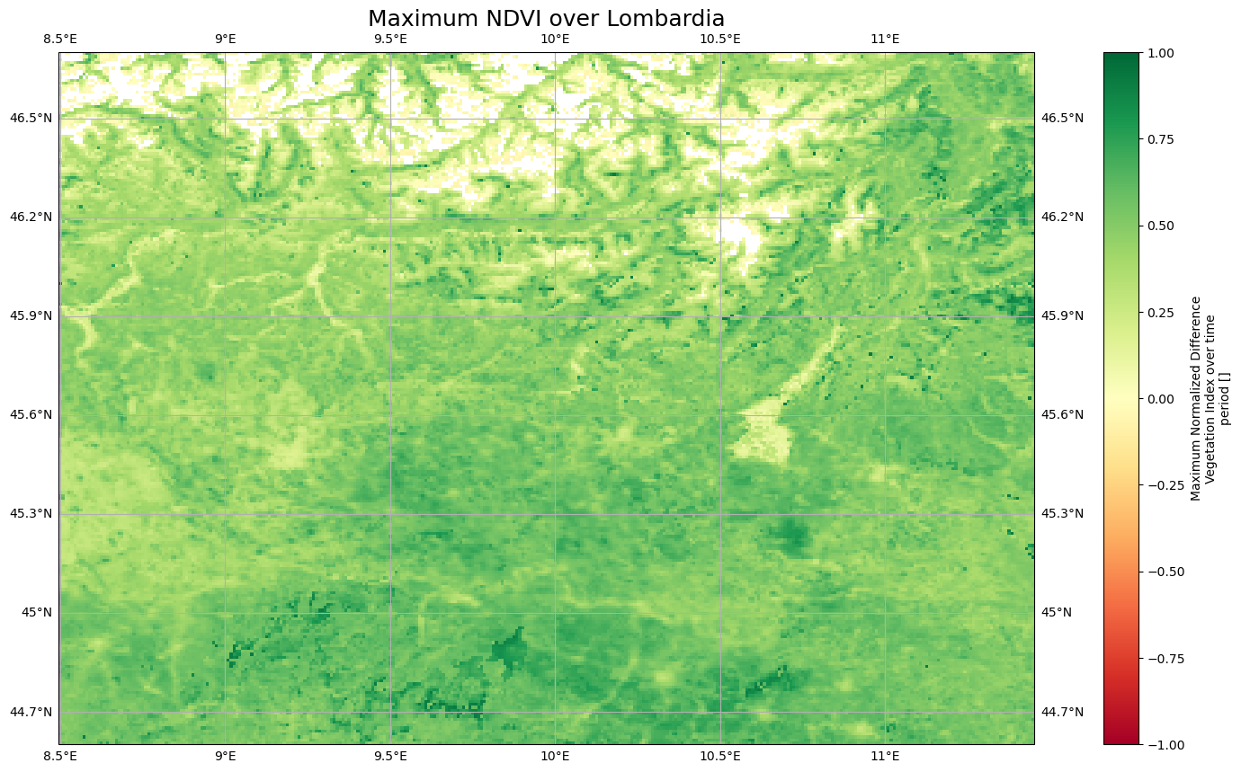
history: 2021-03-01 - Processing line NDVI LTSVisualize maximum NDVI for January 2015#
import matplotlib.pyplot as plt
import cartopy.crs as ccrs
import cartopy.feature as cfeature
fig = plt.figure(1, figsize=[20, 10])

# We're using cartopy and are plotting in PlateCarree projection
# (see documentation on cartopy)
ax = plt.subplot(1, 1, 1, projection=ccrs.PlateCarree())
#ax.set_extent([5, 15, 40, 50], crs=ccrs.PlateCarree()) # lon1 lon2 lat1 lat2
ax.coastlines(resolution='10m')
ax.gridlines(draw_labels=True)

LTS.sel(time="2015-01-01", method="nearest")["max"].plot(ax=ax, vmin=-1, vmax=1, transform=ccrs.PlateCarree(), cmap="RdYlGn")

# One way to customize your title
plt.title("Maximum NDVI over Lombardia", fontsize=18)
Text(0.5, 1.0, 'Maximum NDVI over Lombardia')
/home/runner/micromamba/envs/geohack/lib/python3.12/site-packages/cartopy/io/__init__.py:241: DownloadWarning: Downloading: https://naturalearth.s3.amazonaws.com/10m_physical/ne_10m_coastline.zip
  warnings.warn(f'Downloading: {url}', DownloadWarning)
Tip
If you use one of xarray’s open methods such as xarray.open_dataset to load netCDF files with the default engine, it is recommended to use decode_coords=”all”. This will load the grid mapping variable into coordinates for compatibility with rioxarray. See rioxarray documentation.
Preparing and discover online datasets#
With the plethora of cloud storage, there are many available online datasets. To ease the preparation and discovery of such datasets, we describe emerging community-driven initiatives promoting standards suited to both geospatial and geoscience communities. Most of the material below is adapted from a previous Pangeo 101 training [GAF2)].
Analysis Ready, cloud optimized data (ARCO)#
When analyzing data at scale, the data format used is key. For years, the main data format was netCDF e.g. Network Common Data Form but with the use of cloud computing and interest in Open Science, different formats are often more suitable.
Formats for analyzing data from the cloud are refered to as “Analysis Ready, Cloud Optimized” data formats or in short ARCO. Find further info about ARCO datasets in [SAH+22].
What is “Analysis Ready”?
Think in terms of “Datasets” not “data files”
No need for tedious homogenizing / cleaning setup guides
Curated and cataloged
What is “Cloud Optimized”?
Compatible with object storage e.g. access via HTTP
Supports lazy access and intelligent subsetting
Integrates with high-level analysis libraries and distributed frameworks
Instead of having a big dataset, ARCO datasets are chunked appropriately for analysis and have rich metadata (See Figure 1).

Fig 1. Example of an ARCO dataset. Source: [GAF2)].
Spatio Temporal Asset Catalogs (STAC)#
The STAC specification is a common language to describe geospatial information, so it can more easily be worked with, indexed, and discovered. The development of the STAC specification has simplified and standardized access to satellite datasets. This specification allows users to easily access metadata and raw data, and filter data based on attributes such as satellite type, cloud cover, area of interest, and dates.
Why STAC?#
Each provider has its own catalog and interface (APIs).
Every time you want to access a new catalog, you need to change your program.
We have lots of data providers and each with a bespoke interface.
It is becoming quickly difficult for programmers who need to design a new data connector each time.
Features#
STAC catalogs are extremely simple.
They are composed of three layers:
Catalogs
Collections
Items
STAC is very popular for Earth Observation satellite imagery.
For instance it can be used to access Sentinel-2 in AWS (see Figure 3).

Fig 3. Example of STAC collection of Sentinel-2 images hosted in AWS. Source: [GAF2)].
Python packages to search items from STAC catalogs#
pystac-clientinteracts with SpatioTemporal Asset Catalogs (STAC) to discover and access geospatial data easily.odc-stacis based on Open Data Cube (ODC) and facilitates the management and analysis of large volumes of data accessible from STAC.
from pystac_client import Client
from odc.stac import load
import odc.geo
Search for Items#
Let’s check if items are available for given combination of collection, date, geometry, query, etc.
# use publically available stac link such as
client = Client.open("https://earth-search.aws.element84.com/v1")

# ID of the collection
collection = "sentinel-2-l2a"

# Geometry of AOI e.g. small area over Lombardia (Italy)
geometry = {

        "coordinates": [
          [
            [
              9.621052726784058,
              45.863683047884365
            ],
            [
              9.621052726784058,
              45.72725813387305
            ],
            [
              9.874045082377933,
              45.72725813387305
            ],
            [
              9.874045082377933,
              45.863683047884365
            ],
            [
              9.621052726784058,
              45.863683047884365
            ]
          ]
        ],
    "type": "Polygon",
}
Search items for a specific date#
# Specific Date
date_YYMMDD = "2023-01-01"
# run pystac client search to see available dataset
search = client.search(
    collections=[collection], intersects=geometry, datetime=date_YYMMDD
)
# spit out data as GeoJSON dictionary
print(search.item_collection_as_dict())
Show code cell output
{'type': 'FeatureCollection', 'features': [{'type': 'Feature', 'stac_version': '1.0.0', 'id': 'S2B_32TNR_20230101_0_L2A', 'properties': {'created': '2023-01-01T15:38:00.242Z', 'platform': 'sentinel-2b', 'constellation': 'sentinel-2', 'instruments': ['msi'], 'eo:cloud_cover': 93.50211, 'proj:epsg': 32632, 'mgrs:utm_zone': 32, 'mgrs:latitude_band': 'T', 'mgrs:grid_square': 'NR', 'grid:code': 'MGRS-32TNR', 'view:sun_azimuth': 166.183161249214, 'view:sun_elevation': 20.248337225593005, 's2:degraded_msi_data_percentage': 0.0022, 's2:nodata_pixel_percentage': 0, 's2:saturated_defective_pixel_percentage': 0, 's2:dark_features_percentage': 2.043006, 's2:cloud_shadow_percentage': 4.12275, 's2:vegetation_percentage': 0.054559, 's2:not_vegetated_percentage': 0.154664, 's2:water_percentage': 0.038135, 's2:unclassified_percentage': 0.00642, 's2:medium_proba_clouds_percentage': 7.874592, 's2:high_proba_clouds_percentage': 84.83994, 's2:thin_cirrus_percentage': 0.787582, 's2:snow_ice_percentage': 0.078354, 's2:product_type': 'S2MSI2A', 's2:processing_baseline': '05.09', 's2:product_uri': 'S2B_MSIL2A_20230101T102339_N0509_R065_T32TNR_20230101T113717.SAFE', 's2:generation_time': '2023-01-01T11:37:17.000000Z', 's2:datatake_id': 'GS2B_20230101T102339_030407_N05.09', 's2:datatake_type': 'INS-NOBS', 's2:datastrip_id': 'S2B_OPER_MSI_L2A_DS_2BPS_20230101T113717_S20230101T102333_N05.09', 's2:granule_id': 'S2B_OPER_MSI_L2A_TL_2BPS_20230101T113717_A030407_T32TNR_N05.09', 's2:reflectance_conversion_factor': 1.03412690929912, 'datetime': '2023-01-01T10:28:12.809000Z', 's2:sequence': '0', 'earthsearch:s3_path': 's3://sentinel-cogs/sentinel-s2-l2a-cogs/32/T/NR/2023/1/S2B_32TNR_20230101_0_L2A', 'earthsearch:payload_id': 'roda-sentinel2/workflow-sentinel2-to-stac/315a1af58a55f3166923303539c25ff8', 'earthsearch:boa_offset_applied': True, 'processing:software': {'sentinel2-to-stac': '0.1.0'}, 'updated': '2023-01-01T15:38:00.242Z'}, 'geometry': {'type': 'Polygon', 'coordinates': [[[8.999754387288686, 46.05356536925373], [10.418890992989095, 46.04475738929435], [10.394241393041778, 45.056757746793146], [8.999758655880777, 45.06526899586078], [8.999754387288686, 46.05356536925373]]]}, 'links': [{'rel': 'self', 'type': 'application/geo+json', 'href': 'https://earth-search.aws.element84.com/v1/collections/sentinel-2-l2a/items/S2B_32TNR_20230101_0_L2A'}, {'rel': 'canonical', 'href': 's3://sentinel-cogs/sentinel-s2-l2a-cogs/32/T/NR/2023/1/S2B_32TNR_20230101_0_L2A/S2B_32TNR_20230101_0_L2A.json', 'type': 'application/json'}, {'rel': 'license', 'href': 'https://sentinel.esa.int/documents/247904/690755/Sentinel_Data_Legal_Notice'}, {'rel': 'derived_from', 'href': 'https://earth-search.aws.element84.com/v1/collections/sentinel-2-l1c/items/S2B_32TNR_20230101_0_L1C', 'type': 'application/geo+json'}, {'rel': 'parent', 'type': 'application/json', 'href': 'https://earth-search.aws.element84.com/v1/collections/sentinel-2-l2a'}, {'rel': 'collection', 'type': 'application/json', 'href': 'https://earth-search.aws.element84.com/v1/collections/sentinel-2-l2a'}, {'rel': 'root', 'type': 'application/json', 'href': 'https://earth-search.aws.element84.com/v1'}, {'rel': 'thumbnail', 'href': 'https://earth-search.aws.element84.com/v1/collections/sentinel-2-l2a/items/S2B_32TNR_20230101_0_L2A/thumbnail'}], 'assets': {'aot': {'href': 'https://sentinel-cogs.s3.us-west-2.amazonaws.com/sentinel-s2-l2a-cogs/32/T/NR/2023/1/S2B_32TNR_20230101_0_L2A/AOT.tif', 'type': 'image/tiff; application=geotiff; profile=cloud-optimized', 'title': 'Aerosol optical thickness (AOT)', 'proj:shape': [5490, 5490], 'proj:transform': [20, 0, 499980, 0, -20, 5100000], 'raster:bands': [{'nodata': 0, 'data_type': 'uint16', 'bits_per_sample': 15, 'spatial_resolution': 20, 'scale': 0.001, 'offset': 0}], 'roles': ['data', 'reflectance']}, 'blue': {'href': 'https://sentinel-cogs.s3.us-west-2.amazonaws.com/sentinel-s2-l2a-cogs/32/T/NR/2023/1/S2B_32TNR_20230101_0_L2A/B02.tif', 'type': 'image/tiff; application=geotiff; profile=cloud-optimized', 'title': 'Blue (band 2) - 10m', 'eo:bands': [{'name': 'blue', 'common_name': 'blue', 'description': 'Blue (band 2)', 'center_wavelength': 0.49, 'full_width_half_max': 0.098}], 'gsd': 10, 'proj:shape': [10980, 10980], 'proj:transform': [10, 0, 499980, 0, -10, 5100000], 'raster:bands': [{'nodata': 0, 'data_type': 'uint16', 'bits_per_sample': 15, 'spatial_resolution': 10, 'scale': 0.0001, 'offset': -0.1}], 'roles': ['data', 'reflectance']}, 'coastal': {'href': 'https://sentinel-cogs.s3.us-west-2.amazonaws.com/sentinel-s2-l2a-cogs/32/T/NR/2023/1/S2B_32TNR_20230101_0_L2A/B01.tif', 'type': 'image/tiff; application=geotiff; profile=cloud-optimized', 'title': 'Coastal aerosol (band 1) - 60m', 'eo:bands': [{'name': 'coastal', 'common_name': 'coastal', 'description': 'Coastal aerosol (band 1)', 'center_wavelength': 0.443, 'full_width_half_max': 0.027}], 'gsd': 60, 'proj:shape': [1830, 1830], 'proj:transform': [60, 0, 499980, 0, -60, 5100000], 'raster:bands': [{'nodata': 0, 'data_type': 'uint16', 'bits_per_sample': 15, 'spatial_resolution': 60, 'scale': 0.0001, 'offset': -0.1}], 'roles': ['data', 'reflectance']}, 'granule_metadata': {'href': 'https://sentinel-cogs.s3.us-west-2.amazonaws.com/sentinel-s2-l2a-cogs/32/T/NR/2023/1/S2B_32TNR_20230101_0_L2A/granule_metadata.xml', 'type': 'application/xml', 'roles': ['metadata']}, 'green': {'href': 'https://sentinel-cogs.s3.us-west-2.amazonaws.com/sentinel-s2-l2a-cogs/32/T/NR/2023/1/S2B_32TNR_20230101_0_L2A/B03.tif', 'type': 'image/tiff; application=geotiff; profile=cloud-optimized', 'title': 'Green (band 3) - 10m', 'eo:bands': [{'name': 'green', 'common_name': 'green', 'description': 'Green (band 3)', 'center_wavelength': 0.56, 'full_width_half_max': 0.045}], 'gsd': 10, 'proj:shape': [10980, 10980], 'proj:transform': [10, 0, 499980, 0, -10, 5100000], 'raster:bands': [{'nodata': 0, 'data_type': 'uint16', 'bits_per_sample': 15, 'spatial_resolution': 10, 'scale': 0.0001, 'offset': -0.1}], 'roles': ['data', 'reflectance']}, 'nir': {'href': 'https://sentinel-cogs.s3.us-west-2.amazonaws.com/sentinel-s2-l2a-cogs/32/T/NR/2023/1/S2B_32TNR_20230101_0_L2A/B08.tif', 'type': 'image/tiff; application=geotiff; profile=cloud-optimized', 'title': 'NIR 1 (band 8) - 10m', 'eo:bands': [{'name': 'nir', 'common_name': 'nir', 'description': 'NIR 1 (band 8)', 'center_wavelength': 0.842, 'full_width_half_max': 0.145}], 'gsd': 10, 'proj:shape': [10980, 10980], 'proj:transform': [10, 0, 499980, 0, -10, 5100000], 'raster:bands': [{'nodata': 0, 'data_type': 'uint16', 'bits_per_sample': 15, 'spatial_resolution': 10, 'scale': 0.0001, 'offset': -0.1}], 'roles': ['data', 'reflectance']}, 'nir08': {'href': 'https://sentinel-cogs.s3.us-west-2.amazonaws.com/sentinel-s2-l2a-cogs/32/T/NR/2023/1/S2B_32TNR_20230101_0_L2A/B8A.tif', 'type': 'image/tiff; application=geotiff; profile=cloud-optimized', 'title': 'NIR 2 (band 8A) - 20m', 'eo:bands': [{'name': 'nir08', 'common_name': 'nir08', 'description': 'NIR 2 (band 8A)', 'center_wavelength': 0.865, 'full_width_half_max': 0.033}], 'gsd': 20, 'proj:shape': [5490, 5490], 'proj:transform': [20, 0, 499980, 0, -20, 5100000], 'raster:bands': [{'nodata': 0, 'data_type': 'uint16', 'bits_per_sample': 15, 'spatial_resolution': 20, 'scale': 0.0001, 'offset': -0.1}], 'roles': ['data', 'reflectance']}, 'nir09': {'href': 'https://sentinel-cogs.s3.us-west-2.amazonaws.com/sentinel-s2-l2a-cogs/32/T/NR/2023/1/S2B_32TNR_20230101_0_L2A/B09.tif', 'type': 'image/tiff; application=geotiff; profile=cloud-optimized', 'title': 'NIR 3 (band 9) - 60m', 'eo:bands': [{'name': 'nir09', 'common_name': 'nir09', 'description': 'NIR 3 (band 9)', 'center_wavelength': 0.945, 'full_width_half_max': 0.026}], 'gsd': 60, 'proj:shape': [1830, 1830], 'proj:transform': [60, 0, 499980, 0, -60, 5100000], 'raster:bands': [{'nodata': 0, 'data_type': 'uint16', 'bits_per_sample': 15, 'spatial_resolution': 60, 'scale': 0.0001, 'offset': -0.1}], 'roles': ['data', 'reflectance']}, 'red': {'href': 'https://sentinel-cogs.s3.us-west-2.amazonaws.com/sentinel-s2-l2a-cogs/32/T/NR/2023/1/S2B_32TNR_20230101_0_L2A/B04.tif', 'type': 'image/tiff; application=geotiff; profile=cloud-optimized', 'title': 'Red (band 4) - 10m', 'eo:bands': [{'name': 'red', 'common_name': 'red', 'description': 'Red (band 4)', 'center_wavelength': 0.665, 'full_width_half_max': 0.038}], 'gsd': 10, 'proj:shape': [10980, 10980], 'proj:transform': [10, 0, 499980, 0, -10, 5100000], 'raster:bands': [{'nodata': 0, 'data_type': 'uint16', 'bits_per_sample': 15, 'spatial_resolution': 10, 'scale': 0.0001, 'offset': -0.1}], 'roles': ['data', 'reflectance']}, 'rededge1': {'href': 'https://sentinel-cogs.s3.us-west-2.amazonaws.com/sentinel-s2-l2a-cogs/32/T/NR/2023/1/S2B_32TNR_20230101_0_L2A/B05.tif', 'type': 'image/tiff; application=geotiff; profile=cloud-optimized', 'title': 'Red edge 1 (band 5) - 20m', 'eo:bands': [{'name': 'rededge1', 'common_name': 'rededge', 'description': 'Red edge 1 (band 5)', 'center_wavelength': 0.704, 'full_width_half_max': 0.019}], 'gsd': 20, 'proj:shape': [5490, 5490], 'proj:transform': [20, 0, 499980, 0, -20, 5100000], 'raster:bands': [{'nodata': 0, 'data_type': 'uint16', 'bits_per_sample': 15, 'spatial_resolution': 20, 'scale': 0.0001, 'offset': -0.1}], 'roles': ['data', 'reflectance']}, 'rededge2': {'href': 'https://sentinel-cogs.s3.us-west-2.amazonaws.com/sentinel-s2-l2a-cogs/32/T/NR/2023/1/S2B_32TNR_20230101_0_L2A/B06.tif', 'type': 'image/tiff; application=geotiff; profile=cloud-optimized', 'title': 'Red edge 2 (band 6) - 20m', 'eo:bands': [{'name': 'rededge2', 'common_name': 'rededge', 'description': 'Red edge 2 (band 6)', 'center_wavelength': 0.74, 'full_width_half_max': 0.018}], 'gsd': 20, 'proj:shape': [5490, 5490], 'proj:transform': [20, 0, 499980, 0, -20, 5100000], 'raster:bands': [{'nodata': 0, 'data_type': 'uint16', 'bits_per_sample': 15, 'spatial_resolution': 20, 'scale': 0.0001, 'offset': -0.1}], 'roles': ['data', 'reflectance']}, 'rededge3': {'href': 'https://sentinel-cogs.s3.us-west-2.amazonaws.com/sentinel-s2-l2a-cogs/32/T/NR/2023/1/S2B_32TNR_20230101_0_L2A/B07.tif', 'type': 'image/tiff; application=geotiff; profile=cloud-optimized', 'title': 'Red edge 3 (band 7) - 20m', 'eo:bands': [{'name': 'rededge3', 'common_name': 'rededge', 'description': 'Red edge 3 (band 7)', 'center_wavelength': 0.783, 'full_width_half_max': 0.028}], 'gsd': 20, 'proj:shape': [5490, 5490], 'proj:transform': [20, 0, 499980, 0, -20, 5100000], 'raster:bands': [{'nodata': 0, 'data_type': 'uint16', 'bits_per_sample': 15, 'spatial_resolution': 20, 'scale': 0.0001, 'offset': -0.1}], 'roles': ['data', 'reflectance']}, 'scl': {'href': 'https://sentinel-cogs.s3.us-west-2.amazonaws.com/sentinel-s2-l2a-cogs/32/T/NR/2023/1/S2B_32TNR_20230101_0_L2A/SCL.tif', 'type': 'image/tiff; application=geotiff; profile=cloud-optimized', 'title': 'Scene classification map (SCL)', 'proj:shape': [5490, 5490], 'proj:transform': [20, 0, 499980, 0, -20, 5100000], 'raster:bands': [{'nodata': 0, 'data_type': 'uint8', 'spatial_resolution': 20}], 'roles': ['data', 'reflectance']}, 'swir16': {'href': 'https://sentinel-cogs.s3.us-west-2.amazonaws.com/sentinel-s2-l2a-cogs/32/T/NR/2023/1/S2B_32TNR_20230101_0_L2A/B11.tif', 'type': 'image/tiff; application=geotiff; profile=cloud-optimized', 'title': 'SWIR 1 (band 11) - 20m', 'eo:bands': [{'name': 'swir16', 'common_name': 'swir16', 'description': 'SWIR 1 (band 11)', 'center_wavelength': 1.61, 'full_width_half_max': 0.143}], 'gsd': 20, 'proj:shape': [5490, 5490], 'proj:transform': [20, 0, 499980, 0, -20, 5100000], 'raster:bands': [{'nodata': 0, 'data_type': 'uint16', 'bits_per_sample': 15, 'spatial_resolution': 20, 'scale': 0.0001, 'offset': -0.1}], 'roles': ['data', 'reflectance']}, 'swir22': {'href': 'https://sentinel-cogs.s3.us-west-2.amazonaws.com/sentinel-s2-l2a-cogs/32/T/NR/2023/1/S2B_32TNR_20230101_0_L2A/B12.tif', 'type': 'image/tiff; application=geotiff; profile=cloud-optimized', 'title': 'SWIR 2 (band 12) - 20m', 'eo:bands': [{'name': 'swir22', 'common_name': 'swir22', 'description': 'SWIR 2 (band 12)', 'center_wavelength': 2.19, 'full_width_half_max': 0.242}], 'gsd': 20, 'proj:shape': [5490, 5490], 'proj:transform': [20, 0, 499980, 0, -20, 5100000], 'raster:bands': [{'nodata': 0, 'data_type': 'uint16', 'bits_per_sample': 15, 'spatial_resolution': 20, 'scale': 0.0001, 'offset': -0.1}], 'roles': ['data', 'reflectance']}, 'thumbnail': {'href': 'https://sentinel-cogs.s3.us-west-2.amazonaws.com/sentinel-s2-l2a-cogs/32/T/NR/2023/1/S2B_32TNR_20230101_0_L2A/thumbnail.jpg', 'type': 'image/jpeg', 'title': 'Thumbnail image', 'roles': ['thumbnail']}, 'tileinfo_metadata': {'href': 'https://sentinel-cogs.s3.us-west-2.amazonaws.com/sentinel-s2-l2a-cogs/32/T/NR/2023/1/S2B_32TNR_20230101_0_L2A/tileinfo_metadata.json', 'type': 'application/json', 'roles': ['metadata']}, 'visual': {'href': 'https://sentinel-cogs.s3.us-west-2.amazonaws.com/sentinel-s2-l2a-cogs/32/T/NR/2023/1/S2B_32TNR_20230101_0_L2A/TCI.tif', 'type': 'image/tiff; application=geotiff; profile=cloud-optimized', 'title': 'True color image', 'eo:bands': [{'name': 'red', 'common_name': 'red', 'description': 'Red (band 4)', 'center_wavelength': 0.665, 'full_width_half_max': 0.038}, {'name': 'green', 'common_name': 'green', 'description': 'Green (band 3)', 'center_wavelength': 0.56, 'full_width_half_max': 0.045}, {'name': 'blue', 'common_name': 'blue', 'description': 'Blue (band 2)', 'center_wavelength': 0.49, 'full_width_half_max': 0.098}], 'proj:shape': [10980, 10980], 'proj:transform': [10, 0, 499980, 0, -10, 5100000], 'roles': ['visual']}, 'wvp': {'href': 'https://sentinel-cogs.s3.us-west-2.amazonaws.com/sentinel-s2-l2a-cogs/32/T/NR/2023/1/S2B_32TNR_20230101_0_L2A/WVP.tif', 'type': 'image/tiff; application=geotiff; profile=cloud-optimized', 'title': 'Water vapour (WVP)', 'proj:shape': [5490, 5490], 'proj:transform': [20, 0, 499980, 0, -20, 5100000], 'raster:bands': [{'nodata': 0, 'data_type': 'uint16', 'bits_per_sample': 15, 'spatial_resolution': 20, 'unit': 'cm', 'scale': 0.001, 'offset': 0}], 'roles': ['data', 'reflectance']}, 'aot-jp2': {'href': 's3://sentinel-s2-l2a/tiles/32/T/NR/2023/1/1/0/AOT.jp2', 'type': 'image/jp2', 'title': 'Aerosol optical thickness (AOT)', 'proj:shape': [5490, 5490], 'proj:transform': [20, 0, 499980, 0, -20, 5100000], 'raster:bands': [{'nodata': 0, 'data_type': 'uint16', 'bits_per_sample': 15, 'spatial_resolution': 20, 'scale': 0.001, 'offset': 0}], 'roles': ['data', 'reflectance']}, 'blue-jp2': {'href': 's3://sentinel-s2-l2a/tiles/32/T/NR/2023/1/1/0/B02.jp2', 'type': 'image/jp2', 'title': 'Blue (band 2) - 10m', 'eo:bands': [{'name': 'blue', 'common_name': 'blue', 'description': 'Blue (band 2)', 'center_wavelength': 0.49, 'full_width_half_max': 0.098}], 'gsd': 10, 'proj:shape': [10980, 10980], 'proj:transform': [10, 0, 499980, 0, -10, 5100000], 'raster:bands': [{'nodata': 0, 'data_type': 'uint16', 'bits_per_sample': 15, 'spatial_resolution': 10, 'scale': 0.0001, 'offset': -0.1}], 'roles': ['data', 'reflectance']}, 'coastal-jp2': {'href': 's3://sentinel-s2-l2a/tiles/32/T/NR/2023/1/1/0/B01.jp2', 'type': 'image/jp2', 'title': 'Coastal aerosol (band 1) - 60m', 'eo:bands': [{'name': 'coastal', 'common_name': 'coastal', 'description': 'Coastal aerosol (band 1)', 'center_wavelength': 0.443, 'full_width_half_max': 0.027}], 'gsd': 60, 'proj:shape': [1830, 1830], 'proj:transform': [60, 0, 499980, 0, -60, 5100000], 'raster:bands': [{'nodata': 0, 'data_type': 'uint16', 'bits_per_sample': 15, 'spatial_resolution': 60, 'scale': 0.0001, 'offset': -0.1}], 'roles': ['data', 'reflectance']}, 'green-jp2': {'href': 's3://sentinel-s2-l2a/tiles/32/T/NR/2023/1/1/0/B03.jp2', 'type': 'image/jp2', 'title': 'Green (band 3) - 10m', 'eo:bands': [{'name': 'green', 'common_name': 'green', 'description': 'Green (band 3)', 'center_wavelength': 0.56, 'full_width_half_max': 0.045}], 'gsd': 10, 'proj:shape': [10980, 10980], 'proj:transform': [10, 0, 499980, 0, -10, 5100000], 'raster:bands': [{'nodata': 0, 'data_type': 'uint16', 'bits_per_sample': 15, 'spatial_resolution': 10, 'scale': 0.0001, 'offset': -0.1}], 'roles': ['data', 'reflectance']}, 'nir-jp2': {'href': 's3://sentinel-s2-l2a/tiles/32/T/NR/2023/1/1/0/B08.jp2', 'type': 'image/jp2', 'title': 'NIR 1 (band 8) - 10m', 'eo:bands': [{'name': 'nir', 'common_name': 'nir', 'description': 'NIR 1 (band 8)', 'center_wavelength': 0.842, 'full_width_half_max': 0.145}], 'gsd': 10, 'proj:shape': [10980, 10980], 'proj:transform': [10, 0, 499980, 0, -10, 5100000], 'raster:bands': [{'nodata': 0, 'data_type': 'uint16', 'bits_per_sample': 15, 'spatial_resolution': 10, 'scale': 0.0001, 'offset': -0.1}], 'roles': ['data', 'reflectance']}, 'nir08-jp2': {'href': 's3://sentinel-s2-l2a/tiles/32/T/NR/2023/1/1/0/B8A.jp2', 'type': 'image/jp2', 'title': 'NIR 2 (band 8A) - 20m', 'eo:bands': [{'name': 'nir08', 'common_name': 'nir08', 'description': 'NIR 2 (band 8A)', 'center_wavelength': 0.865, 'full_width_half_max': 0.033}], 'gsd': 20, 'proj:shape': [5490, 5490], 'proj:transform': [20, 0, 499980, 0, -20, 5100000], 'raster:bands': [{'nodata': 0, 'data_type': 'uint16', 'bits_per_sample': 15, 'spatial_resolution': 20, 'scale': 0.0001, 'offset': -0.1}], 'roles': ['data', 'reflectance']}, 'nir09-jp2': {'href': 's3://sentinel-s2-l2a/tiles/32/T/NR/2023/1/1/0/B09.jp2', 'type': 'image/jp2', 'title': 'NIR 3 (band 9) - 60m', 'eo:bands': [{'name': 'nir09', 'common_name': 'nir09', 'description': 'NIR 3 (band 9)', 'center_wavelength': 0.945, 'full_width_half_max': 0.026}], 'gsd': 60, 'proj:shape': [1830, 1830], 'proj:transform': [60, 0, 499980, 0, -60, 5100000], 'raster:bands': [{'nodata': 0, 'data_type': 'uint16', 'bits_per_sample': 15, 'spatial_resolution': 60, 'scale': 0.0001, 'offset': -0.1}], 'roles': ['data', 'reflectance']}, 'red-jp2': {'href': 's3://sentinel-s2-l2a/tiles/32/T/NR/2023/1/1/0/B04.jp2', 'type': 'image/jp2', 'title': 'Red (band 4) - 10m', 'eo:bands': [{'name': 'red', 'common_name': 'red', 'description': 'Red (band 4)', 'center_wavelength': 0.665, 'full_width_half_max': 0.038}], 'gsd': 10, 'proj:shape': [10980, 10980], 'proj:transform': [10, 0, 499980, 0, -10, 5100000], 'raster:bands': [{'nodata': 0, 'data_type': 'uint16', 'bits_per_sample': 15, 'spatial_resolution': 10, 'scale': 0.0001, 'offset': -0.1}], 'roles': ['data', 'reflectance']}, 'rededge1-jp2': {'href': 's3://sentinel-s2-l2a/tiles/32/T/NR/2023/1/1/0/B05.jp2', 'type': 'image/jp2', 'title': 'Red edge 1 (band 5) - 20m', 'eo:bands': [{'name': 'rededge1', 'common_name': 'rededge', 'description': 'Red edge 1 (band 5)', 'center_wavelength': 0.704, 'full_width_half_max': 0.019}], 'gsd': 20, 'proj:shape': [5490, 5490], 'proj:transform': [20, 0, 499980, 0, -20, 5100000], 'raster:bands': [{'nodata': 0, 'data_type': 'uint16', 'bits_per_sample': 15, 'spatial_resolution': 20, 'scale': 0.0001, 'offset': -0.1}], 'roles': ['data', 'reflectance']}, 'rededge2-jp2': {'href': 's3://sentinel-s2-l2a/tiles/32/T/NR/2023/1/1/0/B06.jp2', 'type': 'image/jp2', 'title': 'Red edge 2 (band 6) - 20m', 'eo:bands': [{'name': 'rededge2', 'common_name': 'rededge', 'description': 'Red edge 2 (band 6)', 'center_wavelength': 0.74, 'full_width_half_max': 0.018}], 'gsd': 20, 'proj:shape': [5490, 5490], 'proj:transform': [20, 0, 499980, 0, -20, 5100000], 'raster:bands': [{'nodata': 0, 'data_type': 'uint16', 'bits_per_sample': 15, 'spatial_resolution': 20, 'scale': 0.0001, 'offset': -0.1}], 'roles': ['data', 'reflectance']}, 'rededge3-jp2': {'href': 's3://sentinel-s2-l2a/tiles/32/T/NR/2023/1/1/0/B07.jp2', 'type': 'image/jp2', 'title': 'Red edge 3 (band 7) - 20m', 'eo:bands': [{'name': 'rededge3', 'common_name': 'rededge', 'description': 'Red edge 3 (band 7)', 'center_wavelength': 0.783, 'full_width_half_max': 0.028}], 'gsd': 20, 'proj:shape': [5490, 5490], 'proj:transform': [20, 0, 499980, 0, -20, 5100000], 'raster:bands': [{'nodata': 0, 'data_type': 'uint16', 'bits_per_sample': 15, 'spatial_resolution': 20, 'scale': 0.0001, 'offset': -0.1}], 'roles': ['data', 'reflectance']}, 'scl-jp2': {'href': 's3://sentinel-s2-l2a/tiles/32/T/NR/2023/1/1/0/SCL.jp2', 'type': 'image/jp2', 'title': 'Scene classification map (SCL)', 'proj:shape': [5490, 5490], 'proj:transform': [20, 0, 499980, 0, -20, 5100000], 'raster:bands': [{'nodata': 0, 'data_type': 'uint8', 'spatial_resolution': 20}], 'roles': ['data', 'reflectance']}, 'swir16-jp2': {'href': 's3://sentinel-s2-l2a/tiles/32/T/NR/2023/1/1/0/B11.jp2', 'type': 'image/jp2', 'title': 'SWIR 1 (band 11) - 20m', 'eo:bands': [{'name': 'swir16', 'common_name': 'swir16', 'description': 'SWIR 1 (band 11)', 'center_wavelength': 1.61, 'full_width_half_max': 0.143}], 'gsd': 20, 'proj:shape': [5490, 5490], 'proj:transform': [20, 0, 499980, 0, -20, 5100000], 'raster:bands': [{'nodata': 0, 'data_type': 'uint16', 'bits_per_sample': 15, 'spatial_resolution': 20, 'scale': 0.0001, 'offset': -0.1}], 'roles': ['data', 'reflectance']}, 'swir22-jp2': {'href': 's3://sentinel-s2-l2a/tiles/32/T/NR/2023/1/1/0/B12.jp2', 'type': 'image/jp2', 'title': 'SWIR 2 (band 12) - 20m', 'eo:bands': [{'name': 'swir22', 'common_name': 'swir22', 'description': 'SWIR 2 (band 12)', 'center_wavelength': 2.19, 'full_width_half_max': 0.242}], 'gsd': 20, 'proj:shape': [5490, 5490], 'proj:transform': [20, 0, 499980, 0, -20, 5100000], 'raster:bands': [{'nodata': 0, 'data_type': 'uint16', 'bits_per_sample': 15, 'spatial_resolution': 20, 'scale': 0.0001, 'offset': -0.1}], 'roles': ['data', 'reflectance']}, 'visual-jp2': {'href': 's3://sentinel-s2-l2a/tiles/32/T/NR/2023/1/1/0/TCI.jp2', 'type': 'image/jp2', 'title': 'True color image', 'eo:bands': [{'name': 'red', 'common_name': 'red', 'description': 'Red (band 4)', 'center_wavelength': 0.665, 'full_width_half_max': 0.038}, {'name': 'green', 'common_name': 'green', 'description': 'Green (band 3)', 'center_wavelength': 0.56, 'full_width_half_max': 0.045}, {'name': 'blue', 'common_name': 'blue', 'description': 'Blue (band 2)', 'center_wavelength': 0.49, 'full_width_half_max': 0.098}], 'proj:shape': [10980, 10980], 'proj:transform': [10, 0, 499980, 0, -10, 5100000], 'roles': ['visual']}, 'wvp-jp2': {'href': 's3://sentinel-s2-l2a/tiles/32/T/NR/2023/1/1/0/WVP.jp2', 'type': 'image/jp2', 'title': 'Water vapour (WVP)', 'proj:shape': [5490, 5490], 'proj:transform': [20, 0, 499980, 0, -20, 5100000], 'raster:bands': [{'nodata': 0, 'data_type': 'uint16', 'bits_per_sample': 15, 'spatial_resolution': 20, 'unit': 'cm', 'scale': 0.001, 'offset': 0}], 'roles': ['data', 'reflectance']}}, 'bbox': [8.999754387288686, 45.056757746793146, 10.418890992989095, 46.05356536925373], 'stac_extensions': ['https://stac-extensions.github.io/processing/v1.1.0/schema.json', 'https://stac-extensions.github.io/mgrs/v1.0.0/schema.json', 'https://stac-extensions.github.io/grid/v1.0.0/schema.json', 'https://stac-extensions.github.io/view/v1.0.0/schema.json', 'https://stac-extensions.github.io/eo/v1.0.0/schema.json', 'https://stac-extensions.github.io/raster/v1.1.0/schema.json', 'https://stac-extensions.github.io/projection/v1.0.0/schema.json'], 'collection': 'sentinel-2-l2a'}]}
Search items for a specific month#
# Complete month
date_YYMM = "2023-01"
# run pystac client search to see available dataset
search = client.search(
    collections=[collection], intersects=geometry, datetime=date_YYMM
)
# spit out data as GeoJSON dictionary
print(search.item_collection_as_dict())
# loop through each item
for item in search.items_as_dicts():
    print(item)
Show code cell output
{'type': 'FeatureCollection', 'features': [{'type': 'Feature', 'stac_version': '1.0.0', 'id': 'S2B_32TNR_20230131_0_L2A', 'properties': {'created': '2023-01-31T19:20:02.816Z', 'platform': 'sentinel-2b', 'constellation': 'sentinel-2', 'instruments': ['msi'], 'eo:cloud_cover': 0.112465, 'proj:epsg': 32632, 'mgrs:utm_zone': 32, 'mgrs:latitude_band': 'T', 'mgrs:grid_square': 'NR', 'grid:code': 'MGRS-32TNR', 'view:sun_azimuth': 162.471016303525, 'view:sun_elevation': 25.273284914117596, 's2:degraded_msi_data_percentage': 0.0026, 's2:nodata_pixel_percentage': 3e-05, 's2:saturated_defective_pixel_percentage': 0, 's2:dark_features_percentage': 9.818108, 's2:cloud_shadow_percentage': 0.002522, 's2:vegetation_percentage': 31.585425, 's2:not_vegetated_percentage': 51.599735, 's2:water_percentage': 2.399037, 's2:unclassified_percentage': 0.003381, 's2:medium_proba_clouds_percentage': 0.00499, 's2:high_proba_clouds_percentage': 0.010272, 's2:thin_cirrus_percentage': 0.097203, 's2:snow_ice_percentage': 4.479326, 's2:product_type': 'S2MSI2A', 's2:processing_baseline': '05.09', 's2:product_uri': 'S2B_MSIL2A_20230131T102149_N0509_R065_T32TNR_20230131T131849.SAFE', 's2:generation_time': '2023-01-31T13:18:49.000000Z', 's2:datatake_id': 'GS2B_20230131T102149_030836_N05.09', 's2:datatake_type': 'INS-NOBS', 's2:datastrip_id': 'S2B_OPER_MSI_L2A_DS_2BPS_20230131T131849_S20230131T102549_N05.09', 's2:granule_id': 'S2B_OPER_MSI_L2A_TL_2BPS_20230131T131849_A030836_T32TNR_N05.09', 's2:reflectance_conversion_factor': 1.03138686673961, 'datetime': '2023-01-31T10:28:11.279000Z', 's2:sequence': '0', 'earthsearch:s3_path': 's3://sentinel-cogs/sentinel-s2-l2a-cogs/32/T/NR/2023/1/S2B_32TNR_20230131_0_L2A', 'earthsearch:payload_id': 'roda-sentinel2/workflow-sentinel2-to-stac/7734c7b274348e5d6d4c53ea8a2e5b86', 'earthsearch:boa_offset_applied': True, 'processing:software': {'sentinel2-to-stac': '0.1.0'}, 'updated': '2023-01-31T19:20:02.816Z'}, 'geometry': {'type': 'Polygon', 'coordinates': [[[8.999754387288686, 46.05356536925373], [10.418890992989095, 46.04475738929435], [10.394241393041778, 45.056757746793146], [8.999758655880777, 45.06526899586078], [8.999754387288686, 46.05356536925373]]]}, 'links': [{'rel': 'self', 'type': 'application/geo+json', 'href': 'https://earth-search.aws.element84.com/v1/collections/sentinel-2-l2a/items/S2B_32TNR_20230131_0_L2A'}, {'rel': 'canonical', 'href': 's3://sentinel-cogs/sentinel-s2-l2a-cogs/32/T/NR/2023/1/S2B_32TNR_20230131_0_L2A/S2B_32TNR_20230131_0_L2A.json', 'type': 'application/json'}, {'rel': 'license', 'href': 'https://sentinel.esa.int/documents/247904/690755/Sentinel_Data_Legal_Notice'}, {'rel': 'derived_from', 'href': 'https://earth-search.aws.element84.com/v1/collections/sentinel-2-l1c/items/S2B_32TNR_20230131_0_L1C', 'type': 'application/geo+json'}, {'rel': 'parent', 'type': 'application/json', 'href': 'https://earth-search.aws.element84.com/v1/collections/sentinel-2-l2a'}, {'rel': 'collection', 'type': 'application/json', 'href': 'https://earth-search.aws.element84.com/v1/collections/sentinel-2-l2a'}, {'rel': 'root', 'type': 'application/json', 'href': 'https://earth-search.aws.element84.com/v1'}, {'rel': 'thumbnail', 'href': 'https://earth-search.aws.element84.com/v1/collections/sentinel-2-l2a/items/S2B_32TNR_20230131_0_L2A/thumbnail'}], 'assets': {'aot': {'href': 'https://sentinel-cogs.s3.us-west-2.amazonaws.com/sentinel-s2-l2a-cogs/32/T/NR/2023/1/S2B_32TNR_20230131_0_L2A/AOT.tif', 'type': 'image/tiff; application=geotiff; profile=cloud-optimized', 'title': 'Aerosol optical thickness (AOT)', 'proj:shape': [5490, 5490], 'proj:transform': [20, 0, 499980, 0, -20, 5100000], 'raster:bands': [{'nodata': 0, 'data_type': 'uint16', 'bits_per_sample': 15, 'spatial_resolution': 20, 'scale': 0.001, 'offset': 0}], 'roles': ['data', 'reflectance']}, 'blue': {'href': 'https://sentinel-cogs.s3.us-west-2.amazonaws.com/sentinel-s2-l2a-cogs/32/T/NR/2023/1/S2B_32TNR_20230131_0_L2A/B02.tif', 'type': 'image/tiff; application=geotiff; profile=cloud-optimized', 'title': 'Blue (band 2) - 10m', 'eo:bands': [{'name': 'blue', 'common_name': 'blue', 'description': 'Blue (band 2)', 'center_wavelength': 0.49, 'full_width_half_max': 0.098}], 'gsd': 10, 'proj:shape': [10980, 10980], 'proj:transform': [10, 0, 499980, 0, -10, 5100000], 'raster:bands': [{'nodata': 0, 'data_type': 'uint16', 'bits_per_sample': 15, 'spatial_resolution': 10, 'scale': 0.0001, 'offset': -0.1}], 'roles': ['data', 'reflectance']}, 'coastal': {'href': 'https://sentinel-cogs.s3.us-west-2.amazonaws.com/sentinel-s2-l2a-cogs/32/T/NR/2023/1/S2B_32TNR_20230131_0_L2A/B01.tif', 'type': 'image/tiff; application=geotiff; profile=cloud-optimized', 'title': 'Coastal aerosol (band 1) - 60m', 'eo:bands': [{'name': 'coastal', 'common_name': 'coastal', 'description': 'Coastal aerosol (band 1)', 'center_wavelength': 0.443, 'full_width_half_max': 0.027}], 'gsd': 60, 'proj:shape': [1830, 1830], 'proj:transform': [60, 0, 499980, 0, -60, 5100000], 'raster:bands': [{'nodata': 0, 'data_type': 'uint16', 'bits_per_sample': 15, 'spatial_resolution': 60, 'scale': 0.0001, 'offset': -0.1}], 'roles': ['data', 'reflectance']}, 'granule_metadata': {'href': 'https://sentinel-cogs.s3.us-west-2.amazonaws.com/sentinel-s2-l2a-cogs/32/T/NR/2023/1/S2B_32TNR_20230131_0_L2A/granule_metadata.xml', 'type': 'application/xml', 'roles': ['metadata']}, 'green': {'href': 'https://sentinel-cogs.s3.us-west-2.amazonaws.com/sentinel-s2-l2a-cogs/32/T/NR/2023/1/S2B_32TNR_20230131_0_L2A/B03.tif', 'type': 'image/tiff; application=geotiff; profile=cloud-optimized', 'title': 'Green (band 3) - 10m', 'eo:bands': [{'name': 'green', 'common_name': 'green', 'description': 'Green (band 3)', 'center_wavelength': 0.56, 'full_width_half_max': 0.045}], 'gsd': 10, 'proj:shape': [10980, 10980], 'proj:transform': [10, 0, 499980, 0, -10, 5100000], 'raster:bands': [{'nodata': 0, 'data_type': 'uint16', 'bits_per_sample': 15, 'spatial_resolution': 10, 'scale': 0.0001, 'offset': -0.1}], 'roles': ['data', 'reflectance']}, 'nir': {'href': 'https://sentinel-cogs.s3.us-west-2.amazonaws.com/sentinel-s2-l2a-cogs/32/T/NR/2023/1/S2B_32TNR_20230131_0_L2A/B08.tif', 'type': 'image/tiff; application=geotiff; profile=cloud-optimized', 'title': 'NIR 1 (band 8) - 10m', 'eo:bands': [{'name': 'nir', 'common_name': 'nir', 'description': 'NIR 1 (band 8)', 'center_wavelength': 0.842, 'full_width_half_max': 0.145}], 'gsd': 10, 'proj:shape': [10980, 10980], 'proj:transform': [10, 0, 499980, 0, -10, 5100000], 'raster:bands': [{'nodata': 0, 'data_type': 'uint16', 'bits_per_sample': 15, 'spatial_resolution': 10, 'scale': 0.0001, 'offset': -0.1}], 'roles': ['data', 'reflectance']}, 'nir08': {'href': 'https://sentinel-cogs.s3.us-west-2.amazonaws.com/sentinel-s2-l2a-cogs/32/T/NR/2023/1/S2B_32TNR_20230131_0_L2A/B8A.tif', 'type': 'image/tiff; application=geotiff; profile=cloud-optimized', 'title': 'NIR 2 (band 8A) - 20m', 'eo:bands': [{'name': 'nir08', 'common_name': 'nir08', 'description': 'NIR 2 (band 8A)', 'center_wavelength': 0.865, 'full_width_half_max': 0.033}], 'gsd': 20, 'proj:shape': [5490, 5490], 'proj:transform': [20, 0, 499980, 0, -20, 5100000], 'raster:bands': [{'nodata': 0, 'data_type': 'uint16', 'bits_per_sample': 15, 'spatial_resolution': 20, 'scale': 0.0001, 'offset': -0.1}], 'roles': ['data', 'reflectance']}, 'nir09': {'href': 'https://sentinel-cogs.s3.us-west-2.amazonaws.com/sentinel-s2-l2a-cogs/32/T/NR/2023/1/S2B_32TNR_20230131_0_L2A/B09.tif', 'type': 'image/tiff; application=geotiff; profile=cloud-optimized', 'title': 'NIR 3 (band 9) - 60m', 'eo:bands': [{'name': 'nir09', 'common_name': 'nir09', 'description': 'NIR 3 (band 9)', 'center_wavelength': 0.945, 'full_width_half_max': 0.026}], 'gsd': 60, 'proj:shape': [1830, 1830], 'proj:transform': [60, 0, 499980, 0, -60, 5100000], 'raster:bands': [{'nodata': 0, 'data_type': 'uint16', 'bits_per_sample': 15, 'spatial_resolution': 60, 'scale': 0.0001, 'offset': -0.1}], 'roles': ['data', 'reflectance']}, 'red': {'href': 'https://sentinel-cogs.s3.us-west-2.amazonaws.com/sentinel-s2-l2a-cogs/32/T/NR/2023/1/S2B_32TNR_20230131_0_L2A/B04.tif', 'type': 'image/tiff; application=geotiff; profile=cloud-optimized', 'title': 'Red (band 4) - 10m', 'eo:bands': [{'name': 'red', 'common_name': 'red', 'description': 'Red (band 4)', 'center_wavelength': 0.665, 'full_width_half_max': 0.038}], 'gsd': 10, 'proj:shape': [10980, 10980], 'proj:transform': [10, 0, 499980, 0, -10, 5100000], 'raster:bands': [{'nodata': 0, 'data_type': 'uint16', 'bits_per_sample': 15, 'spatial_resolution': 10, 'scale': 0.0001, 'offset': -0.1}], 'roles': ['data', 'reflectance']}, 'rededge1': {'href': 'https://sentinel-cogs.s3.us-west-2.amazonaws.com/sentinel-s2-l2a-cogs/32/T/NR/2023/1/S2B_32TNR_20230131_0_L2A/B05.tif', 'type': 'image/tiff; application=geotiff; profile=cloud-optimized', 'title': 'Red edge 1 (band 5) - 20m', 'eo:bands': [{'name': 'rededge1', 'common_name': 'rededge', 'description': 'Red edge 1 (band 5)', 'center_wavelength': 0.704, 'full_width_half_max': 0.019}], 'gsd': 20, 'proj:shape': [5490, 5490], 'proj:transform': [20, 0, 499980, 0, -20, 5100000], 'raster:bands': [{'nodata': 0, 'data_type': 'uint16', 'bits_per_sample': 15, 'spatial_resolution': 20, 'scale': 0.0001, 'offset': -0.1}], 'roles': ['data', 'reflectance']}, 'rededge2': {'href': 'https://sentinel-cogs.s3.us-west-2.amazonaws.com/sentinel-s2-l2a-cogs/32/T/NR/2023/1/S2B_32TNR_20230131_0_L2A/B06.tif', 'type': 'image/tiff; application=geotiff; profile=cloud-optimized', 'title': 'Red edge 2 (band 6) - 20m', 'eo:bands': [{'name': 'rededge2', 'common_name': 'rededge', 'description': 'Red edge 2 (band 6)', 'center_wavelength': 0.74, 'full_width_half_max': 0.018}], 'gsd': 20, 'proj:shape': [5490, 5490], 'proj:transform': [20, 0, 499980, 0, -20, 5100000], 'raster:bands': [{'nodata': 0, 'data_type': 'uint16', 'bits_per_sample': 15, 'spatial_resolution': 20, 'scale': 0.0001, 'offset': -0.1}], 'roles': ['data', 'reflectance']}, 'rededge3': {'href': 'https://sentinel-cogs.s3.us-west-2.amazonaws.com/sentinel-s2-l2a-cogs/32/T/NR/2023/1/S2B_32TNR_20230131_0_L2A/B07.tif', 'type': 'image/tiff; application=geotiff; profile=cloud-optimized', 'title': 'Red edge 3 (band 7) - 20m', 'eo:bands': [{'name': 'rededge3', 'common_name': 'rededge', 'description': 'Red edge 3 (band 7)', 'center_wavelength': 0.783, 'full_width_half_max': 0.028}], 'gsd': 20, 'proj:shape': [5490, 5490], 'proj:transform': [20, 0, 499980, 0, -20, 5100000], 'raster:bands': [{'nodata': 0, 'data_type': 'uint16', 'bits_per_sample': 15, 'spatial_resolution': 20, 'scale': 0.0001, 'offset': -0.1}], 'roles': ['data', 'reflectance']}, 'scl': {'href': 'https://sentinel-cogs.s3.us-west-2.amazonaws.com/sentinel-s2-l2a-cogs/32/T/NR/2023/1/S2B_32TNR_20230131_0_L2A/SCL.tif', 'type': 'image/tiff; application=geotiff; profile=cloud-optimized', 'title': 'Scene classification map (SCL)', 'proj:shape': [5490, 5490], 'proj:transform': [20, 0, 499980, 0, -20, 5100000], 'raster:bands': [{'nodata': 0, 'data_type': 'uint8', 'spatial_resolution': 20}], 'roles': ['data', 'reflectance']}, 'swir16': {'href': 'https://sentinel-cogs.s3.us-west-2.amazonaws.com/sentinel-s2-l2a-cogs/32/T/NR/2023/1/S2B_32TNR_20230131_0_L2A/B11.tif', 'type': 'image/tiff; application=geotiff; profile=cloud-optimized', 'title': 'SWIR 1 (band 11) - 20m', 'eo:bands': [{'name': 'swir16', 'common_name': 'swir16', 'description': 'SWIR 1 (band 11)', 'center_wavelength': 1.61, 'full_width_half_max': 0.143}], 'gsd': 20, 'proj:shape': [5490, 5490], 'proj:transform': [20, 0, 499980, 0, -20, 5100000], 'raster:bands': [{'nodata': 0, 'data_type': 'uint16', 'bits_per_sample': 15, 'spatial_resolution': 20, 'scale': 0.0001, 'offset': -0.1}], 'roles': ['data', 'reflectance']}, 'swir22': {'href': 'https://sentinel-cogs.s3.us-west-2.amazonaws.com/sentinel-s2-l2a-cogs/32/T/NR/2023/1/S2B_32TNR_20230131_0_L2A/B12.tif', 'type': 'image/tiff; application=geotiff; profile=cloud-optimized', 'title': 'SWIR 2 (band 12) - 20m', 'eo:bands': [{'name': 'swir22', 'common_name': 'swir22', 'description': 'SWIR 2 (band 12)', 'center_wavelength': 2.19, 'full_width_half_max': 0.242}], 'gsd': 20, 'proj:shape': [5490, 5490], 'proj:transform': [20, 0, 499980, 0, -20, 5100000], 'raster:bands': [{'nodata': 0, 'data_type': 'uint16', 'bits_per_sample': 15, 'spatial_resolution': 20, 'scale': 0.0001, 'offset': -0.1}], 'roles': ['data', 'reflectance']}, 'thumbnail': {'href': 'https://sentinel-cogs.s3.us-west-2.amazonaws.com/sentinel-s2-l2a-cogs/32/T/NR/2023/1/S2B_32TNR_20230131_0_L2A/thumbnail.jpg', 'type': 'image/jpeg', 'title': 'Thumbnail image', 'roles': ['thumbnail']}, 'tileinfo_metadata': {'href': 'https://sentinel-cogs.s3.us-west-2.amazonaws.com/sentinel-s2-l2a-cogs/32/T/NR/2023/1/S2B_32TNR_20230131_0_L2A/tileinfo_metadata.json', 'type': 'application/json', 'roles': ['metadata']}, 'visual': {'href': 'https://sentinel-cogs.s3.us-west-2.amazonaws.com/sentinel-s2-l2a-cogs/32/T/NR/2023/1/S2B_32TNR_20230131_0_L2A/TCI.tif', 'type': 'image/tiff; application=geotiff; profile=cloud-optimized', 'title': 'True color image', 'eo:bands': [{'name': 'red', 'common_name': 'red', 'description': 'Red (band 4)', 'center_wavelength': 0.665, 'full_width_half_max': 0.038}, {'name': 'green', 'common_name': 'green', 'description': 'Green (band 3)', 'center_wavelength': 0.56, 'full_width_half_max': 0.045}, {'name': 'blue', 'common_name': 'blue', 'description': 'Blue (band 2)', 'center_wavelength': 0.49, 'full_width_half_max': 0.098}], 'proj:shape': [10980, 10980], 'proj:transform': [10, 0, 499980, 0, -10, 5100000], 'roles': ['visual']}, 'wvp': {'href': 'https://sentinel-cogs.s3.us-west-2.amazonaws.com/sentinel-s2-l2a-cogs/32/T/NR/2023/1/S2B_32TNR_20230131_0_L2A/WVP.tif', 'type': 'image/tiff; application=geotiff; profile=cloud-optimized', 'title': 'Water vapour (WVP)', 'proj:shape': [5490, 5490], 'proj:transform': [20, 0, 499980, 0, -20, 5100000], 'raster:bands': [{'nodata': 0, 'data_type': 'uint16', 'bits_per_sample': 15, 'spatial_resolution': 20, 'unit': 'cm', 'scale': 0.001, 'offset': 0}], 'roles': ['data', 'reflectance']}, 'aot-jp2': {'href': 's3://sentinel-s2-l2a/tiles/32/T/NR/2023/1/31/0/AOT.jp2', 'type': 'image/jp2', 'title': 'Aerosol optical thickness (AOT)', 'proj:shape': [5490, 5490], 'proj:transform': [20, 0, 499980, 0, -20, 5100000], 'raster:bands': [{'nodata': 0, 'data_type': 'uint16', 'bits_per_sample': 15, 'spatial_resolution': 20, 'scale': 0.001, 'offset': 0}], 'roles': ['data', 'reflectance']}, 'blue-jp2': {'href': 's3://sentinel-s2-l2a/tiles/32/T/NR/2023/1/31/0/B02.jp2', 'type': 'image/jp2', 'title': 'Blue (band 2) - 10m', 'eo:bands': [{'name': 'blue', 'common_name': 'blue', 'description': 'Blue (band 2)', 'center_wavelength': 0.49, 'full_width_half_max': 0.098}], 'gsd': 10, 'proj:shape': [10980, 10980], 'proj:transform': [10, 0, 499980, 0, -10, 5100000], 'raster:bands': [{'nodata': 0, 'data_type': 'uint16', 'bits_per_sample': 15, 'spatial_resolution': 10, 'scale': 0.0001, 'offset': -0.1}], 'roles': ['data', 'reflectance']}, 'coastal-jp2': {'href': 's3://sentinel-s2-l2a/tiles/32/T/NR/2023/1/31/0/B01.jp2', 'type': 'image/jp2', 'title': 'Coastal aerosol (band 1) - 60m', 'eo:bands': [{'name': 'coastal', 'common_name': 'coastal', 'description': 'Coastal aerosol (band 1)', 'center_wavelength': 0.443, 'full_width_half_max': 0.027}], 'gsd': 60, 'proj:shape': [1830, 1830], 'proj:transform': [60, 0, 499980, 0, -60, 5100000], 'raster:bands': [{'nodata': 0, 'data_type': 'uint16', 'bits_per_sample': 15, 'spatial_resolution': 60, 'scale': 0.0001, 'offset': -0.1}], 'roles': ['data', 'reflectance']}, 'green-jp2': {'href': 's3://sentinel-s2-l2a/tiles/32/T/NR/2023/1/31/0/B03.jp2', 'type': 'image/jp2', 'title': 'Green (band 3) - 10m', 'eo:bands': [{'name': 'green', 'common_name': 'green', 'description': 'Green (band 3)', 'center_wavelength': 0.56, 'full_width_half_max': 0.045}], 'gsd': 10, 'proj:shape': [10980, 10980], 'proj:transform': [10, 0, 499980, 0, -10, 5100000], 'raster:bands': [{'nodata': 0, 'data_type': 'uint16', 'bits_per_sample': 15, 'spatial_resolution': 10, 'scale': 0.0001, 'offset': -0.1}], 'roles': ['data', 'reflectance']}, 'nir-jp2': {'href': 's3://sentinel-s2-l2a/tiles/32/T/NR/2023/1/31/0/B08.jp2', 'type': 'image/jp2', 'title': 'NIR 1 (band 8) - 10m', 'eo:bands': [{'name': 'nir', 'common_name': 'nir', 'description': 'NIR 1 (band 8)', 'center_wavelength': 0.842, 'full_width_half_max': 0.145}], 'gsd': 10, 'proj:shape': [10980, 10980], 'proj:transform': [10, 0, 499980, 0, -10, 5100000], 'raster:bands': [{'nodata': 0, 'data_type': 'uint16', 'bits_per_sample': 15, 'spatial_resolution': 10, 'scale': 0.0001, 'offset': -0.1}], 'roles': ['data', 'reflectance']}, 'nir08-jp2': {'href': 's3://sentinel-s2-l2a/tiles/32/T/NR/2023/1/31/0/B8A.jp2', 'type': 'image/jp2', 'title': 'NIR 2 (band 8A) - 20m', 'eo:bands': [{'name': 'nir08', 'common_name': 'nir08', 'description': 'NIR 2 (band 8A)', 'center_wavelength': 0.865, 'full_width_half_max': 0.033}], 'gsd': 20, 'proj:shape': [5490, 5490], 'proj:transform': [20, 0, 499980, 0, -20, 5100000], 'raster:bands': [{'nodata': 0, 'data_type': 'uint16', 'bits_per_sample': 15, 'spatial_resolution': 20, 'scale': 0.0001, 'offset': -0.1}], 'roles': ['data', 'reflectance']}, 'nir09-jp2': {'href': 's3://sentinel-s2-l2a/tiles/32/T/NR/2023/1/31/0/B09.jp2', 'type': 'image/jp2', 'title': 'NIR 3 (band 9) - 60m', 'eo:bands': [{'name': 'nir09', 'common_name': 'nir09', 'description': 'NIR 3 (band 9)', 'center_wavelength': 0.945, 'full_width_half_max': 0.026}], 'gsd': 60, 'proj:shape': [1830, 1830], 'proj:transform': [60, 0, 499980, 0, -60, 5100000], 'raster:bands': [{'nodata': 0, 'data_type': 'uint16', 'bits_per_sample': 15, 'spatial_resolution': 60, 'scale': 0.0001, 'offset': -0.1}], 'roles': ['data', 'reflectance']}, 'red-jp2': {'href': 's3://sentinel-s2-l2a/tiles/32/T/NR/2023/1/31/0/B04.jp2', 'type': 'image/jp2', 'title': 'Red (band 4) - 10m', 'eo:bands': [{'name': 'red', 'common_name': 'red', 'description': 'Red (band 4)', 'center_wavelength': 0.665, 'full_width_half_max': 0.038}], 'gsd': 10, 'proj:shape': [10980, 10980], 'proj:transform': [10, 0, 499980, 0, -10, 5100000], 'raster:bands': [{'nodata': 0, 'data_type': 'uint16', 'bits_per_sample': 15, 'spatial_resolution': 10, 'scale': 0.0001, 'offset': -0.1}], 'roles': ['data', 'reflectance']}, 'rededge1-jp2': {'href': 's3://sentinel-s2-l2a/tiles/32/T/NR/2023/1/31/0/B05.jp2', 'type': 'image/jp2', 'title': 'Red edge 1 (band 5) - 20m', 'eo:bands': [{'name': 'rededge1', 'common_name': 'rededge', 'description': 'Red edge 1 (band 5)', 'center_wavelength': 0.704, 'full_width_half_max': 0.019}], 'gsd': 20, 'proj:shape': [5490, 5490], 'proj:transform': [20, 0, 499980, 0, -20, 5100000], 'raster:bands': [{'nodata': 0, 'data_type': 'uint16', 'bits_per_sample': 15, 'spatial_resolution': 20, 'scale': 0.0001, 'offset': -0.1}], 'roles': ['data', 'reflectance']}, 'rededge2-jp2': {'href': 's3://sentinel-s2-l2a/tiles/32/T/NR/2023/1/31/0/B06.jp2', 'type': 'image/jp2', 'title': 'Red edge 2 (band 6) - 20m', 'eo:bands': [{'name': 'rededge2', 'common_name': 'rededge', 'description': 'Red edge 2 (band 6)', 'center_wavelength': 0.74, 'full_width_half_max': 0.018}], 'gsd': 20, 'proj:shape': [5490, 5490], 'proj:transform': [20, 0, 499980, 0, -20, 5100000], 'raster:bands': [{'nodata': 0, 'data_type': 'uint16', 'bits_per_sample': 15, 'spatial_resolution': 20, 'scale': 0.0001, 'offset': -0.1}], 'roles': ['data', 'reflectance']}, 'rededge3-jp2': {'href': 's3://sentinel-s2-l2a/tiles/32/T/NR/2023/1/31/0/B07.jp2', 'type': 'image/jp2', 'title': 'Red edge 3 (band 7) - 20m', 'eo:bands': [{'name': 'rededge3', 'common_name': 'rededge', 'description': 'Red edge 3 (band 7)', 'center_wavelength': 0.783, 'full_width_half_max': 0.028}], 'gsd': 20, 'proj:shape': [5490, 5490], 'proj:transform': [20, 0, 499980, 0, -20, 5100000], 'raster:bands': [{'nodata': 0, 'data_type': 'uint16', 'bits_per_sample': 15, 'spatial_resolution': 20, 'scale': 0.0001, 'offset': -0.1}], 'roles': ['data', 'reflectance']}, 'scl-jp2': {'href': 's3://sentinel-s2-l2a/tiles/32/T/NR/2023/1/31/0/SCL.jp2', 'type': 'image/jp2', 'title': 'Scene classification map (SCL)', 'proj:shape': [5490, 5490], 'proj:transform': [20, 0, 499980, 0, -20, 5100000], 'raster:bands': [{'nodata': 0, 'data_type': 'uint8', 'spatial_resolution': 20}], 'roles': ['data', 'reflectance']}, 'swir16-jp2': {'href': 's3://sentinel-s2-l2a/tiles/32/T/NR/2023/1/31/0/B11.jp2', 'type': 'image/jp2', 'title': 'SWIR 1 (band 11) - 20m', 'eo:bands': [{'name': 'swir16', 'common_name': 'swir16', 'description': 'SWIR 1 (band 11)', 'center_wavelength': 1.61, 'full_width_half_max': 0.143}], 'gsd': 20, 'proj:shape': [5490, 5490], 'proj:transform': [20, 0, 499980, 0, -20, 5100000], 'raster:bands': [{'nodata': 0, 'data_type': 'uint16', 'bits_per_sample': 15, 'spatial_resolution': 20, 'scale': 0.0001, 'offset': -0.1}], 'roles': ['data', 'reflectance']}, 'swir22-jp2': {'href': 's3://sentinel-s2-l2a/tiles/32/T/NR/2023/1/31/0/B12.jp2', 'type': 'image/jp2', 'title': 'SWIR 2 (band 12) - 20m', 'eo:bands': [{'name': 'swir22', 'common_name': 'swir22', 'description': 'SWIR 2 (band 12)', 'center_wavelength': 2.19, 'full_width_half_max': 0.242}], 'gsd': 20, 'proj:shape': [5490, 5490], 'proj:transform': [20, 0, 499980, 0, -20, 5100000], 'raster:bands': [{'nodata': 0, 'data_type': 'uint16', 'bits_per_sample': 15, 'spatial_resolution': 20, 'scale': 0.0001, 'offset': -0.1}], 'roles': ['data', 'reflectance']}, 'visual-jp2': {'href': 's3://sentinel-s2-l2a/tiles/32/T/NR/2023/1/31/0/TCI.jp2', 'type': 'image/jp2', 'title': 'True color image', 'eo:bands': [{'name': 'red', 'common_name': 'red', 'description': 'Red (band 4)', 'center_wavelength': 0.665, 'full_width_half_max': 0.038}, {'name': 'green', 'common_name': 'green', 'description': 'Green (band 3)', 'center_wavelength': 0.56, 'full_width_half_max': 0.045}, {'name': 'blue', 'common_name': 'blue', 'description': 'Blue (band 2)', 'center_wavelength': 0.49, 'full_width_half_max': 0.098}], 'proj:shape': [10980, 10980], 'proj:transform': [10, 0, 499980, 0, -10, 5100000], 'roles': ['visual']}, 'wvp-jp2': {'href': 's3://sentinel-s2-l2a/tiles/32/T/NR/2023/1/31/0/WVP.jp2', 'type': 'image/jp2', 'title': 'Water vapour (WVP)', 'proj:shape': [5490, 5490], 'proj:transform': [20, 0, 499980, 0, -20, 5100000], 'raster:bands': [{'nodata': 0, 'data_type': 'uint16', 'bits_per_sample': 15, 'spatial_resolution': 20, 'unit': 'cm', 'scale': 0.001, 'offset': 0}], 'roles': ['data', 'reflectance']}}, 'bbox': [8.999754387288686, 45.056757746793146, 10.418890992989095, 46.05356536925373], 'stac_extensions': ['https://stac-extensions.github.io/processing/v1.1.0/schema.json', 'https://stac-extensions.github.io/eo/v1.0.0/schema.json', 'https://stac-extensions.github.io/view/v1.0.0/schema.json', 'https://stac-extensions.github.io/grid/v1.0.0/schema.json', 'https://stac-extensions.github.io/projection/v1.0.0/schema.json', 'https://stac-extensions.github.io/raster/v1.1.0/schema.json', 'https://stac-extensions.github.io/mgrs/v1.0.0/schema.json'], 'collection': 'sentinel-2-l2a'}, {'type': 'Feature', 'stac_version': '1.0.0', 'id': 'S2A_32TNR_20230126_0_L2A', 'properties': {'created': '2023-01-26T17:37:32.993Z', 'platform': 'sentinel-2a', 'constellation': 'sentinel-2', 'instruments': ['msi'], 'eo:cloud_cover': 73.252439, 'proj:epsg': 32632, 'mgrs:utm_zone': 32, 'mgrs:latitude_band': 'T', 'mgrs:grid_square': 'NR', 'grid:code': 'MGRS-32TNR', 'view:sun_azimuth': 163.024854791439, 'view:sun_elevation': 24.023377982022893, 's2:degraded_msi_data_percentage': 0.0073, 's2:nodata_pixel_percentage': 1e-05, 's2:saturated_defective_pixel_percentage': 0, 's2:dark_features_percentage': 6.976229, 's2:cloud_shadow_percentage': 0.96215, 's2:vegetation_percentage': 1.920419, 's2:not_vegetated_percentage': 8.183733, 's2:water_percentage': 1.235301, 's2:unclassified_percentage': 2.569909, 's2:medium_proba_clouds_percentage': 18.082398, 's2:high_proba_clouds_percentage': 54.566461, 's2:thin_cirrus_percentage': 0.603585, 's2:snow_ice_percentage': 4.899822, 's2:product_type': 'S2MSI2A', 's2:processing_baseline': '05.09', 's2:product_uri': 'S2A_MSIL2A_20230126T102311_N0509_R065_T32TNR_20230126T140003.SAFE', 's2:generation_time': '2023-01-26T14:00:03.000000Z', 's2:datatake_id': 'GS2A_20230126T102311_039673_N05.09', 's2:datatake_type': 'INS-NOBS', 's2:datastrip_id': 'S2A_OPER_MSI_L2A_DS_2APS_20230126T140003_S20230126T102309_N05.09', 's2:granule_id': 'S2A_OPER_MSI_L2A_TL_2APS_20230126T140003_A039673_T32TNR_N05.09', 's2:reflectance_conversion_factor': 1.0324729322178, 'datetime': '2023-01-26T10:28:11.353000Z', 's2:sequence': '0', 'earthsearch:s3_path': 's3://sentinel-cogs/sentinel-s2-l2a-cogs/32/T/NR/2023/1/S2A_32TNR_20230126_0_L2A', 'earthsearch:payload_id': 'roda-sentinel2/workflow-sentinel2-to-stac/5f6fdf1dcf54ceebfd0f1755f162f030', 'earthsearch:boa_offset_applied': True, 'processing:software': {'sentinel2-to-stac': '0.1.0'}, 'updated': '2023-01-26T17:37:32.993Z'}, 'geometry': {'type': 'Polygon', 'coordinates': [[[8.999754387288686, 46.05356536925373], [10.418890992989095, 46.04475738929435], [10.394241393041778, 45.056757746793146], [8.999758655880777, 45.06526899586078], [8.999754387288686, 46.05356536925373]]]}, 'links': [{'rel': 'self', 'type': 'application/geo+json', 'href': 'https://earth-search.aws.element84.com/v1/collections/sentinel-2-l2a/items/S2A_32TNR_20230126_0_L2A'}, {'rel': 'canonical', 'href': 's3://sentinel-cogs/sentinel-s2-l2a-cogs/32/T/NR/2023/1/S2A_32TNR_20230126_0_L2A/S2A_32TNR_20230126_0_L2A.json', 'type': 'application/json'}, {'rel': 'license', 'href': 'https://sentinel.esa.int/documents/247904/690755/Sentinel_Data_Legal_Notice'}, {'rel': 'derived_from', 'href': 'https://earth-search.aws.element84.com/v1/collections/sentinel-2-l1c/items/S2A_32TNR_20230126_0_L1C', 'type': 'application/geo+json'}, {'rel': 'parent', 'type': 'application/json', 'href': 'https://earth-search.aws.element84.com/v1/collections/sentinel-2-l2a'}, {'rel': 'collection', 'type': 'application/json', 'href': 'https://earth-search.aws.element84.com/v1/collections/sentinel-2-l2a'}, {'rel': 'root', 'type': 'application/json', 'href': 'https://earth-search.aws.element84.com/v1'}, {'rel': 'thumbnail', 'href': 'https://earth-search.aws.element84.com/v1/collections/sentinel-2-l2a/items/S2A_32TNR_20230126_0_L2A/thumbnail'}], 'assets': {'aot': {'href': 'https://sentinel-cogs.s3.us-west-2.amazonaws.com/sentinel-s2-l2a-cogs/32/T/NR/2023/1/S2A_32TNR_20230126_0_L2A/AOT.tif', 'type': 'image/tiff; application=geotiff; profile=cloud-optimized', 'title': 'Aerosol optical thickness (AOT)', 'proj:shape': [5490, 5490], 'proj:transform': [20, 0, 499980, 0, -20, 5100000], 'raster:bands': [{'nodata': 0, 'data_type': 'uint16', 'bits_per_sample': 15, 'spatial_resolution': 20, 'scale': 0.001, 'offset': 0}], 'roles': ['data', 'reflectance']}, 'blue': {'href': 'https://sentinel-cogs.s3.us-west-2.amazonaws.com/sentinel-s2-l2a-cogs/32/T/NR/2023/1/S2A_32TNR_20230126_0_L2A/B02.tif', 'type': 'image/tiff; application=geotiff; profile=cloud-optimized', 'title': 'Blue (band 2) - 10m', 'eo:bands': [{'name': 'blue', 'common_name': 'blue', 'description': 'Blue (band 2)', 'center_wavelength': 0.49, 'full_width_half_max': 0.098}], 'gsd': 10, 'proj:shape': [10980, 10980], 'proj:transform': [10, 0, 499980, 0, -10, 5100000], 'raster:bands': [{'nodata': 0, 'data_type': 'uint16', 'bits_per_sample': 15, 'spatial_resolution': 10, 'scale': 0.0001, 'offset': -0.1}], 'roles': ['data', 'reflectance']}, 'coastal': {'href': 'https://sentinel-cogs.s3.us-west-2.amazonaws.com/sentinel-s2-l2a-cogs/32/T/NR/2023/1/S2A_32TNR_20230126_0_L2A/B01.tif', 'type': 'image/tiff; application=geotiff; profile=cloud-optimized', 'title': 'Coastal aerosol (band 1) - 60m', 'eo:bands': [{'name': 'coastal', 'common_name': 'coastal', 'description': 'Coastal aerosol (band 1)', 'center_wavelength': 0.443, 'full_width_half_max': 0.027}], 'gsd': 60, 'proj:shape': [1830, 1830], 'proj:transform': [60, 0, 499980, 0, -60, 5100000], 'raster:bands': [{'nodata': 0, 'data_type': 'uint16', 'bits_per_sample': 15, 'spatial_resolution': 60, 'scale': 0.0001, 'offset': -0.1}], 'roles': ['data', 'reflectance']}, 'granule_metadata': {'href': 'https://sentinel-cogs.s3.us-west-2.amazonaws.com/sentinel-s2-l2a-cogs/32/T/NR/2023/1/S2A_32TNR_20230126_0_L2A/granule_metadata.xml', 'type': 'application/xml', 'roles': ['metadata']}, 'green': {'href': 'https://sentinel-cogs.s3.us-west-2.amazonaws.com/sentinel-s2-l2a-cogs/32/T/NR/2023/1/S2A_32TNR_20230126_0_L2A/B03.tif', 'type': 'image/tiff; application=geotiff; profile=cloud-optimized', 'title': 'Green (band 3) - 10m', 'eo:bands': [{'name': 'green', 'common_name': 'green', 'description': 'Green (band 3)', 'center_wavelength': 0.56, 'full_width_half_max': 0.045}], 'gsd': 10, 'proj:shape': [10980, 10980], 'proj:transform': [10, 0, 499980, 0, -10, 5100000], 'raster:bands': [{'nodata': 0, 'data_type': 'uint16', 'bits_per_sample': 15, 'spatial_resolution': 10, 'scale': 0.0001, 'offset': -0.1}], 'roles': ['data', 'reflectance']}, 'nir': {'href': 'https://sentinel-cogs.s3.us-west-2.amazonaws.com/sentinel-s2-l2a-cogs/32/T/NR/2023/1/S2A_32TNR_20230126_0_L2A/B08.tif', 'type': 'image/tiff; application=geotiff; profile=cloud-optimized', 'title': 'NIR 1 (band 8) - 10m', 'eo:bands': [{'name': 'nir', 'common_name': 'nir', 'description': 'NIR 1 (band 8)', 'center_wavelength': 0.842, 'full_width_half_max': 0.145}], 'gsd': 10, 'proj:shape': [10980, 10980], 'proj:transform': [10, 0, 499980, 0, -10, 5100000], 'raster:bands': [{'nodata': 0, 'data_type': 'uint16', 'bits_per_sample': 15, 'spatial_resolution': 10, 'scale': 0.0001, 'offset': -0.1}], 'roles': ['data', 'reflectance']}, 'nir08': {'href': 'https://sentinel-cogs.s3.us-west-2.amazonaws.com/sentinel-s2-l2a-cogs/32/T/NR/2023/1/S2A_32TNR_20230126_0_L2A/B8A.tif', 'type': 'image/tiff; application=geotiff; profile=cloud-optimized', 'title': 'NIR 2 (band 8A) - 20m', 'eo:bands': [{'name': 'nir08', 'common_name': 'nir08', 'description': 'NIR 2 (band 8A)', 'center_wavelength': 0.865, 'full_width_half_max': 0.033}], 'gsd': 20, 'proj:shape': [5490, 5490], 'proj:transform': [20, 0, 499980, 0, -20, 5100000], 'raster:bands': [{'nodata': 0, 'data_type': 'uint16', 'bits_per_sample': 15, 'spatial_resolution': 20, 'scale': 0.0001, 'offset': -0.1}], 'roles': ['data', 'reflectance']}, 'nir09': {'href': 'https://sentinel-cogs.s3.us-west-2.amazonaws.com/sentinel-s2-l2a-cogs/32/T/NR/2023/1/S2A_32TNR_20230126_0_L2A/B09.tif', 'type': 'image/tiff; application=geotiff; profile=cloud-optimized', 'title': 'NIR 3 (band 9) - 60m', 'eo:bands': [{'name': 'nir09', 'common_name': 'nir09', 'description': 'NIR 3 (band 9)', 'center_wavelength': 0.945, 'full_width_half_max': 0.026}], 'gsd': 60, 'proj:shape': [1830, 1830], 'proj:transform': [60, 0, 499980, 0, -60, 5100000], 'raster:bands': [{'nodata': 0, 'data_type': 'uint16', 'bits_per_sample': 15, 'spatial_resolution': 60, 'scale': 0.0001, 'offset': -0.1}], 'roles': ['data', 'reflectance']}, 'red': {'href': 'https://sentinel-cogs.s3.us-west-2.amazonaws.com/sentinel-s2-l2a-cogs/32/T/NR/2023/1/S2A_32TNR_20230126_0_L2A/B04.tif', 'type': 'image/tiff; application=geotiff; profile=cloud-optimized', 'title': 'Red (band 4) - 10m', 'eo:bands': [{'name': 'red', 'common_name': 'red', 'description': 'Red (band 4)', 'center_wavelength': 0.665, 'full_width_half_max': 0.038}], 'gsd': 10, 'proj:shape': [10980, 10980], 'proj:transform': [10, 0, 499980, 0, -10, 5100000], 'raster:bands': [{'nodata': 0, 'data_type': 'uint16', 'bits_per_sample': 15, 'spatial_resolution': 10, 'scale': 0.0001, 'offset': -0.1}], 'roles': ['data', 'reflectance']}, 'rededge1': {'href': 'https://sentinel-cogs.s3.us-west-2.amazonaws.com/sentinel-s2-l2a-cogs/32/T/NR/2023/1/S2A_32TNR_20230126_0_L2A/B05.tif', 'type': 'image/tiff; application=geotiff; profile=cloud-optimized', 'title': 'Red edge 1 (band 5) - 20m', 'eo:bands': [{'name': 'rededge1', 'common_name': 'rededge', 'description': 'Red edge 1 (band 5)', 'center_wavelength': 0.704, 'full_width_half_max': 0.019}], 'gsd': 20, 'proj:shape': [5490, 5490], 'proj:transform': [20, 0, 499980, 0, -20, 5100000], 'raster:bands': [{'nodata': 0, 'data_type': 'uint16', 'bits_per_sample': 15, 'spatial_resolution': 20, 'scale': 0.0001, 'offset': -0.1}], 'roles': ['data', 'reflectance']}, 'rededge2': {'href': 'https://sentinel-cogs.s3.us-west-2.amazonaws.com/sentinel-s2-l2a-cogs/32/T/NR/2023/1/S2A_32TNR_20230126_0_L2A/B06.tif', 'type': 'image/tiff; application=geotiff; profile=cloud-optimized', 'title': 'Red edge 2 (band 6) - 20m', 'eo:bands': [{'name': 'rededge2', 'common_name': 'rededge', 'description': 'Red edge 2 (band 6)', 'center_wavelength': 0.74, 'full_width_half_max': 0.018}], 'gsd': 20, 'proj:shape': [5490, 5490], 'proj:transform': [20, 0, 499980, 0, -20, 5100000], 'raster:bands': [{'nodata': 0, 'data_type': 'uint16', 'bits_per_sample': 15, 'spatial_resolution': 20, 'scale': 0.0001, 'offset': -0.1}], 'roles': ['data', 'reflectance']}, 'rededge3': {'href': 'https://sentinel-cogs.s3.us-west-2.amazonaws.com/sentinel-s2-l2a-cogs/32/T/NR/2023/1/S2A_32TNR_20230126_0_L2A/B07.tif', 'type': 'image/tiff; application=geotiff; profile=cloud-optimized', 'title': 'Red edge 3 (band 7) - 20m', 'eo:bands': [{'name': 'rededge3', 'common_name': 'rededge', 'description': 'Red edge 3 (band 7)', 'center_wavelength': 0.783, 'full_width_half_max': 0.028}], 'gsd': 20, 'proj:shape': [5490, 5490], 'proj:transform': [20, 0, 499980, 0, -20, 5100000], 'raster:bands': [{'nodata': 0, 'data_type': 'uint16', 'bits_per_sample': 15, 'spatial_resolution': 20, 'scale': 0.0001, 'offset': -0.1}], 'roles': ['data', 'reflectance']}, 'scl': {'href': 'https://sentinel-cogs.s3.us-west-2.amazonaws.com/sentinel-s2-l2a-cogs/32/T/NR/2023/1/S2A_32TNR_20230126_0_L2A/SCL.tif', 'type': 'image/tiff; application=geotiff; profile=cloud-optimized', 'title': 'Scene classification map (SCL)', 'proj:shape': [5490, 5490], 'proj:transform': [20, 0, 499980, 0, -20, 5100000], 'raster:bands': [{'nodata': 0, 'data_type': 'uint8', 'spatial_resolution': 20}], 'roles': ['data', 'reflectance']}, 'swir16': {'href': 'https://sentinel-cogs.s3.us-west-2.amazonaws.com/sentinel-s2-l2a-cogs/32/T/NR/2023/1/S2A_32TNR_20230126_0_L2A/B11.tif', 'type': 'image/tiff; application=geotiff; profile=cloud-optimized', 'title': 'SWIR 1 (band 11) - 20m', 'eo:bands': [{'name': 'swir16', 'common_name': 'swir16', 'description': 'SWIR 1 (band 11)', 'center_wavelength': 1.61, 'full_width_half_max': 0.143}], 'gsd': 20, 'proj:shape': [5490, 5490], 'proj:transform': [20, 0, 499980, 0, -20, 5100000], 'raster:bands': [{'nodata': 0, 'data_type': 'uint16', 'bits_per_sample': 15, 'spatial_resolution': 20, 'scale': 0.0001, 'offset': -0.1}], 'roles': ['data', 'reflectance']}, 'swir22': {'href': 'https://sentinel-cogs.s3.us-west-2.amazonaws.com/sentinel-s2-l2a-cogs/32/T/NR/2023/1/S2A_32TNR_20230126_0_L2A/B12.tif', 'type': 'image/tiff; application=geotiff; profile=cloud-optimized', 'title': 'SWIR 2 (band 12) - 20m', 'eo:bands': [{'name': 'swir22', 'common_name': 'swir22', 'description': 'SWIR 2 (band 12)', 'center_wavelength': 2.19, 'full_width_half_max': 0.242}], 'gsd': 20, 'proj:shape': [5490, 5490], 'proj:transform': [20, 0, 499980, 0, -20, 5100000], 'raster:bands': [{'nodata': 0, 'data_type': 'uint16', 'bits_per_sample': 15, 'spatial_resolution': 20, 'scale': 0.0001, 'offset': -0.1}], 'roles': ['data', 'reflectance']}, 'thumbnail': {'href': 'https://sentinel-cogs.s3.us-west-2.amazonaws.com/sentinel-s2-l2a-cogs/32/T/NR/2023/1/S2A_32TNR_20230126_0_L2A/thumbnail.jpg', 'type': 'image/jpeg', 'title': 'Thumbnail image', 'roles': ['thumbnail']}, 'tileinfo_metadata': {'href': 'https://sentinel-cogs.s3.us-west-2.amazonaws.com/sentinel-s2-l2a-cogs/32/T/NR/2023/1/S2A_32TNR_20230126_0_L2A/tileinfo_metadata.json', 'type': 'application/json', 'roles': ['metadata']}, 'visual': {'href': 'https://sentinel-cogs.s3.us-west-2.amazonaws.com/sentinel-s2-l2a-cogs/32/T/NR/2023/1/S2A_32TNR_20230126_0_L2A/TCI.tif', 'type': 'image/tiff; application=geotiff; profile=cloud-optimized', 'title': 'True color image', 'eo:bands': [{'name': 'red', 'common_name': 'red', 'description': 'Red (band 4)', 'center_wavelength': 0.665, 'full_width_half_max': 0.038}, {'name': 'green', 'common_name': 'green', 'description': 'Green (band 3)', 'center_wavelength': 0.56, 'full_width_half_max': 0.045}, {'name': 'blue', 'common_name': 'blue', 'description': 'Blue (band 2)', 'center_wavelength': 0.49, 'full_width_half_max': 0.098}], 'proj:shape': [10980, 10980], 'proj:transform': [10, 0, 499980, 0, -10, 5100000], 'roles': ['visual']}, 'wvp': {'href': 'https://sentinel-cogs.s3.us-west-2.amazonaws.com/sentinel-s2-l2a-cogs/32/T/NR/2023/1/S2A_32TNR_20230126_0_L2A/WVP.tif', 'type': 'image/tiff; application=geotiff; profile=cloud-optimized', 'title': 'Water vapour (WVP)', 'proj:shape': [5490, 5490], 'proj:transform': [20, 0, 499980, 0, -20, 5100000], 'raster:bands': [{'nodata': 0, 'data_type': 'uint16', 'bits_per_sample': 15, 'spatial_resolution': 20, 'unit': 'cm', 'scale': 0.001, 'offset': 0}], 'roles': ['data', 'reflectance']}, 'aot-jp2': {'href': 's3://sentinel-s2-l2a/tiles/32/T/NR/2023/1/26/0/AOT.jp2', 'type': 'image/jp2', 'title': 'Aerosol optical thickness (AOT)', 'proj:shape': [5490, 5490], 'proj:transform': [20, 0, 499980, 0, -20, 5100000], 'raster:bands': [{'nodata': 0, 'data_type': 'uint16', 'bits_per_sample': 15, 'spatial_resolution': 20, 'scale': 0.001, 'offset': 0}], 'roles': ['data', 'reflectance']}, 'blue-jp2': {'href': 's3://sentinel-s2-l2a/tiles/32/T/NR/2023/1/26/0/B02.jp2', 'type': 'image/jp2', 'title': 'Blue (band 2) - 10m', 'eo:bands': [{'name': 'blue', 'common_name': 'blue', 'description': 'Blue (band 2)', 'center_wavelength': 0.49, 'full_width_half_max': 0.098}], 'gsd': 10, 'proj:shape': [10980, 10980], 'proj:transform': [10, 0, 499980, 0, -10, 5100000], 'raster:bands': [{'nodata': 0, 'data_type': 'uint16', 'bits_per_sample': 15, 'spatial_resolution': 10, 'scale': 0.0001, 'offset': -0.1}], 'roles': ['data', 'reflectance']}, 'coastal-jp2': {'href': 's3://sentinel-s2-l2a/tiles/32/T/NR/2023/1/26/0/B01.jp2', 'type': 'image/jp2', 'title': 'Coastal aerosol (band 1) - 60m', 'eo:bands': [{'name': 'coastal', 'common_name': 'coastal', 'description': 'Coastal aerosol (band 1)', 'center_wavelength': 0.443, 'full_width_half_max': 0.027}], 'gsd': 60, 'proj:shape': [1830, 1830], 'proj:transform': [60, 0, 499980, 0, -60, 5100000], 'raster:bands': [{'nodata': 0, 'data_type': 'uint16', 'bits_per_sample': 15, 'spatial_resolution': 60, 'scale': 0.0001, 'offset': -0.1}], 'roles': ['data', 'reflectance']}, 'green-jp2': {'href': 's3://sentinel-s2-l2a/tiles/32/T/NR/2023/1/26/0/B03.jp2', 'type': 'image/jp2', 'title': 'Green (band 3) - 10m', 'eo:bands': [{'name': 'green', 'common_name': 'green', 'description': 'Green (band 3)', 'center_wavelength': 0.56, 'full_width_half_max': 0.045}], 'gsd': 10, 'proj:shape': [10980, 10980], 'proj:transform': [10, 0, 499980, 0, -10, 5100000], 'raster:bands': [{'nodata': 0, 'data_type': 'uint16', 'bits_per_sample': 15, 'spatial_resolution': 10, 'scale': 0.0001, 'offset': -0.1}], 'roles': ['data', 'reflectance']}, 'nir-jp2': {'href': 's3://sentinel-s2-l2a/tiles/32/T/NR/2023/1/26/0/B08.jp2', 'type': 'image/jp2', 'title': 'NIR 1 (band 8) - 10m', 'eo:bands': [{'name': 'nir', 'common_name': 'nir', 'description': 'NIR 1 (band 8)', 'center_wavelength': 0.842, 'full_width_half_max': 0.145}], 'gsd': 10, 'proj:shape': [10980, 10980], 'proj:transform': [10, 0, 499980, 0, -10, 5100000], 'raster:bands': [{'nodata': 0, 'data_type': 'uint16', 'bits_per_sample': 15, 'spatial_resolution': 10, 'scale': 0.0001, 'offset': -0.1}], 'roles': ['data', 'reflectance']}, 'nir08-jp2': {'href': 's3://sentinel-s2-l2a/tiles/32/T/NR/2023/1/26/0/B8A.jp2', 'type': 'image/jp2', 'title': 'NIR 2 (band 8A) - 20m', 'eo:bands': [{'name': 'nir08', 'common_name': 'nir08', 'description': 'NIR 2 (band 8A)', 'center_wavelength': 0.865, 'full_width_half_max': 0.033}], 'gsd': 20, 'proj:shape': [5490, 5490], 'proj:transform': [20, 0, 499980, 0, -20, 5100000], 'raster:bands': [{'nodata': 0, 'data_type': 'uint16', 'bits_per_sample': 15, 'spatial_resolution': 20, 'scale': 0.0001, 'offset': -0.1}], 'roles': ['data', 'reflectance']}, 'nir09-jp2': {'href': 's3://sentinel-s2-l2a/tiles/32/T/NR/2023/1/26/0/B09.jp2', 'type': 'image/jp2', 'title': 'NIR 3 (band 9) - 60m', 'eo:bands': [{'name': 'nir09', 'common_name': 'nir09', 'description': 'NIR 3 (band 9)', 'center_wavelength': 0.945, 'full_width_half_max': 0.026}], 'gsd': 60, 'proj:shape': [1830, 1830], 'proj:transform': [60, 0, 499980, 0, -60, 5100000], 'raster:bands': [{'nodata': 0, 'data_type': 'uint16', 'bits_per_sample': 15, 'spatial_resolution': 60, 'scale': 0.0001, 'offset': -0.1}], 'roles': ['data', 'reflectance']}, 'red-jp2': {'href': 's3://sentinel-s2-l2a/tiles/32/T/NR/2023/1/26/0/B04.jp2', 'type': 'image/jp2', 'title': 'Red (band 4) - 10m', 'eo:bands': [{'name': 'red', 'common_name': 'red', 'description': 'Red (band 4)', 'center_wavelength': 0.665, 'full_width_half_max': 0.038}], 'gsd': 10, 'proj:shape': [10980, 10980], 'proj:transform': [10, 0, 499980, 0, -10, 5100000], 'raster:bands': [{'nodata': 0, 'data_type': 'uint16', 'bits_per_sample': 15, 'spatial_resolution': 10, 'scale': 0.0001, 'offset': -0.1}], 'roles': ['data', 'reflectance']}, 'rededge1-jp2': {'href': 's3://sentinel-s2-l2a/tiles/32/T/NR/2023/1/26/0/B05.jp2', 'type': 'image/jp2', 'title': 'Red edge 1 (band 5) - 20m', 'eo:bands': [{'name': 'rededge1', 'common_name': 'rededge', 'description': 'Red edge 1 (band 5)', 'center_wavelength': 0.704, 'full_width_half_max': 0.019}], 'gsd': 20, 'proj:shape': [5490, 5490], 'proj:transform': [20, 0, 499980, 0, -20, 5100000], 'raster:bands': [{'nodata': 0, 'data_type': 'uint16', 'bits_per_sample': 15, 'spatial_resolution': 20, 'scale': 0.0001, 'offset': -0.1}], 'roles': ['data', 'reflectance']}, 'rededge2-jp2': {'href': 's3://sentinel-s2-l2a/tiles/32/T/NR/2023/1/26/0/B06.jp2', 'type': 'image/jp2', 'title': 'Red edge 2 (band 6) - 20m', 'eo:bands': [{'name': 'rededge2', 'common_name': 'rededge', 'description': 'Red edge 2 (band 6)', 'center_wavelength': 0.74, 'full_width_half_max': 0.018}], 'gsd': 20, 'proj:shape': [5490, 5490], 'proj:transform': [20, 0, 499980, 0, -20, 5100000], 'raster:bands': [{'nodata': 0, 'data_type': 'uint16', 'bits_per_sample': 15, 'spatial_resolution': 20, 'scale': 0.0001, 'offset': -0.1}], 'roles': ['data', 'reflectance']}, 'rededge3-jp2': {'href': 's3://sentinel-s2-l2a/tiles/32/T/NR/2023/1/26/0/B07.jp2', 'type': 'image/jp2', 'title': 'Red edge 3 (band 7) - 20m', 'eo:bands': [{'name': 'rededge3', 'common_name': 'rededge', 'description': 'Red edge 3 (band 7)', 'center_wavelength': 0.783, 'full_width_half_max': 0.028}], 'gsd': 20, 'proj:shape': [5490, 5490], 'proj:transform': [20, 0, 499980, 0, -20, 5100000], 'raster:bands': [{'nodata': 0, 'data_type': 'uint16', 'bits_per_sample': 15, 'spatial_resolution': 20, 'scale': 0.0001, 'offset': -0.1}], 'roles': ['data', 'reflectance']}, 'scl-jp2': {'href': 's3://sentinel-s2-l2a/tiles/32/T/NR/2023/1/26/0/SCL.jp2', 'type': 'image/jp2', 'title': 'Scene classification map (SCL)', 'proj:shape': [5490, 5490], 'proj:transform': [20, 0, 499980, 0, -20, 5100000], 'raster:bands': [{'nodata': 0, 'data_type': 'uint8', 'spatial_resolution': 20}], 'roles': ['data', 'reflectance']}, 'swir16-jp2': {'href': 's3://sentinel-s2-l2a/tiles/32/T/NR/2023/1/26/0/B11.jp2', 'type': 'image/jp2', 'title': 'SWIR 1 (band 11) - 20m', 'eo:bands': [{'name': 'swir16', 'common_name': 'swir16', 'description': 'SWIR 1 (band 11)', 'center_wavelength': 1.61, 'full_width_half_max': 0.143}], 'gsd': 20, 'proj:shape': [5490, 5490], 'proj:transform': [20, 0, 499980, 0, -20, 5100000], 'raster:bands': [{'nodata': 0, 'data_type': 'uint16', 'bits_per_sample': 15, 'spatial_resolution': 20, 'scale': 0.0001, 'offset': -0.1}], 'roles': ['data', 'reflectance']}, 'swir22-jp2': {'href': 's3://sentinel-s2-l2a/tiles/32/T/NR/2023/1/26/0/B12.jp2', 'type': 'image/jp2', 'title': 'SWIR 2 (band 12) - 20m', 'eo:bands': [{'name': 'swir22', 'common_name': 'swir22', 'description': 'SWIR 2 (band 12)', 'center_wavelength': 2.19, 'full_width_half_max': 0.242}], 'gsd': 20, 'proj:shape': [5490, 5490], 'proj:transform': [20, 0, 499980, 0, -20, 5100000], 'raster:bands': [{'nodata': 0, 'data_type': 'uint16', 'bits_per_sample': 15, 'spatial_resolution': 20, 'scale': 0.0001, 'offset': -0.1}], 'roles': ['data', 'reflectance']}, 'visual-jp2': {'href': 's3://sentinel-s2-l2a/tiles/32/T/NR/2023/1/26/0/TCI.jp2', 'type': 'image/jp2', 'title': 'True color image', 'eo:bands': [{'name': 'red', 'common_name': 'red', 'description': 'Red (band 4)', 'center_wavelength': 0.665, 'full_width_half_max': 0.038}, {'name': 'green', 'common_name': 'green', 'description': 'Green (band 3)', 'center_wavelength': 0.56, 'full_width_half_max': 0.045}, {'name': 'blue', 'common_name': 'blue', 'description': 'Blue (band 2)', 'center_wavelength': 0.49, 'full_width_half_max': 0.098}], 'proj:shape': [10980, 10980], 'proj:transform': [10, 0, 499980, 0, -10, 5100000], 'roles': ['visual']}, 'wvp-jp2': {'href': 's3://sentinel-s2-l2a/tiles/32/T/NR/2023/1/26/0/WVP.jp2', 'type': 'image/jp2', 'title': 'Water vapour (WVP)', 'proj:shape': [5490, 5490], 'proj:transform': [20, 0, 499980, 0, -20, 5100000], 'raster:bands': [{'nodata': 0, 'data_type': 'uint16', 'bits_per_sample': 15, 'spatial_resolution': 20, 'unit': 'cm', 'scale': 0.001, 'offset': 0}], 'roles': ['data', 'reflectance']}}, 'bbox': [8.999754387288686, 45.056757746793146, 10.418890992989095, 46.05356536925373], 'stac_extensions': ['https://stac-extensions.github.io/processing/v1.1.0/schema.json', 'https://stac-extensions.github.io/raster/v1.1.0/schema.json', 'https://stac-extensions.github.io/eo/v1.0.0/schema.json', 'https://stac-extensions.github.io/view/v1.0.0/schema.json', 'https://stac-extensions.github.io/projection/v1.0.0/schema.json', 'https://stac-extensions.github.io/grid/v1.0.0/schema.json', 'https://stac-extensions.github.io/mgrs/v1.0.0/schema.json'], 'collection': 'sentinel-2-l2a'}, {'type': 'Feature', 'stac_version': '1.0.0', 'id': 'S2B_32TNR_20230121_0_L2A', 'properties': {'created': '2023-01-21T17:42:59.862Z', 'platform': 'sentinel-2b', 'constellation': 'sentinel-2', 'instruments': ['msi'], 'eo:cloud_cover': 68.40564, 'proj:epsg': 32632, 'mgrs:utm_zone': 32, 'mgrs:latitude_band': 'T', 'mgrs:grid_square': 'NR', 'grid:code': 'MGRS-32TNR', 'view:sun_azimuth': 163.618644211077, 'view:sun_elevation': 22.926297910763907, 's2:degraded_msi_data_percentage': 0.0021, 's2:nodata_pixel_percentage': 0, 's2:saturated_defective_pixel_percentage': 0, 's2:dark_features_percentage': 5.138951, 's2:cloud_shadow_percentage': 0.037983, 's2:vegetation_percentage': 6.790299, 's2:not_vegetated_percentage': 11.790837, 's2:water_percentage': 0.552928, 's2:unclassified_percentage': 0.03364, 's2:medium_proba_clouds_percentage': 38.76327, 's2:high_proba_clouds_percentage': 10.687659, 's2:thin_cirrus_percentage': 18.954715, 's2:snow_ice_percentage': 7.24972, 's2:product_type': 'S2MSI2A', 's2:processing_baseline': '05.09', 's2:product_uri': 'S2B_MSIL2A_20230121T102239_N0509_R065_T32TNR_20230121T113700.SAFE', 's2:generation_time': '2023-01-21T11:37:00.000000Z', 's2:datatake_id': 'GS2B_20230121T102239_030693_N05.09', 's2:datatake_type': 'INS-NOBS', 's2:datastrip_id': 'S2B_OPER_MSI_L2A_DS_2BPS_20230121T113700_S20230121T102235_N05.09', 's2:granule_id': 'S2B_OPER_MSI_L2A_TL_2BPS_20230121T113700_A030693_T32TNR_N05.09', 's2:reflectance_conversion_factor': 1.03331481581973, 'datetime': '2023-01-21T10:28:11.907000Z', 's2:sequence': '0', 'earthsearch:s3_path': 's3://sentinel-cogs/sentinel-s2-l2a-cogs/32/T/NR/2023/1/S2B_32TNR_20230121_0_L2A', 'earthsearch:payload_id': 'roda-sentinel2/workflow-sentinel2-to-stac/ec2614c790532ccbbfae14d05b5e9f0d', 'earthsearch:boa_offset_applied': True, 'processing:software': {'sentinel2-to-stac': '0.1.0'}, 'updated': '2023-01-21T17:42:59.862Z'}, 'geometry': {'type': 'Polygon', 'coordinates': [[[8.999754387288686, 46.05356536925373], [10.418890992989095, 46.04475738929435], [10.394241393041778, 45.056757746793146], [8.999758655880777, 45.06526899586078], [8.999754387288686, 46.05356536925373]]]}, 'links': [{'rel': 'self', 'type': 'application/geo+json', 'href': 'https://earth-search.aws.element84.com/v1/collections/sentinel-2-l2a/items/S2B_32TNR_20230121_0_L2A'}, {'rel': 'canonical', 'href': 's3://sentinel-cogs/sentinel-s2-l2a-cogs/32/T/NR/2023/1/S2B_32TNR_20230121_0_L2A/S2B_32TNR_20230121_0_L2A.json', 'type': 'application/json'}, {'rel': 'license', 'href': 'https://sentinel.esa.int/documents/247904/690755/Sentinel_Data_Legal_Notice'}, {'rel': 'derived_from', 'href': 'https://earth-search.aws.element84.com/v1/collections/sentinel-2-l1c/items/S2B_32TNR_20230121_0_L1C', 'type': 'application/geo+json'}, {'rel': 'parent', 'type': 'application/json', 'href': 'https://earth-search.aws.element84.com/v1/collections/sentinel-2-l2a'}, {'rel': 'collection', 'type': 'application/json', 'href': 'https://earth-search.aws.element84.com/v1/collections/sentinel-2-l2a'}, {'rel': 'root', 'type': 'application/json', 'href': 'https://earth-search.aws.element84.com/v1'}, {'rel': 'thumbnail', 'href': 'https://earth-search.aws.element84.com/v1/collections/sentinel-2-l2a/items/S2B_32TNR_20230121_0_L2A/thumbnail'}], 'assets': {'aot': {'href': 'https://sentinel-cogs.s3.us-west-2.amazonaws.com/sentinel-s2-l2a-cogs/32/T/NR/2023/1/S2B_32TNR_20230121_0_L2A/AOT.tif', 'type': 'image/tiff; application=geotiff; profile=cloud-optimized', 'title': 'Aerosol optical thickness (AOT)', 'proj:shape': [5490, 5490], 'proj:transform': [20, 0, 499980, 0, -20, 5100000], 'raster:bands': [{'nodata': 0, 'data_type': 'uint16', 'bits_per_sample': 15, 'spatial_resolution': 20, 'scale': 0.001, 'offset': 0}], 'roles': ['data', 'reflectance']}, 'blue': {'href': 'https://sentinel-cogs.s3.us-west-2.amazonaws.com/sentinel-s2-l2a-cogs/32/T/NR/2023/1/S2B_32TNR_20230121_0_L2A/B02.tif', 'type': 'image/tiff; application=geotiff; profile=cloud-optimized', 'title': 'Blue (band 2) - 10m', 'eo:bands': [{'name': 'blue', 'common_name': 'blue', 'description': 'Blue (band 2)', 'center_wavelength': 0.49, 'full_width_half_max': 0.098}], 'gsd': 10, 'proj:shape': [10980, 10980], 'proj:transform': [10, 0, 499980, 0, -10, 5100000], 'raster:bands': [{'nodata': 0, 'data_type': 'uint16', 'bits_per_sample': 15, 'spatial_resolution': 10, 'scale': 0.0001, 'offset': -0.1}], 'roles': ['data', 'reflectance']}, 'coastal': {'href': 'https://sentinel-cogs.s3.us-west-2.amazonaws.com/sentinel-s2-l2a-cogs/32/T/NR/2023/1/S2B_32TNR_20230121_0_L2A/B01.tif', 'type': 'image/tiff; application=geotiff; profile=cloud-optimized', 'title': 'Coastal aerosol (band 1) - 60m', 'eo:bands': [{'name': 'coastal', 'common_name': 'coastal', 'description': 'Coastal aerosol (band 1)', 'center_wavelength': 0.443, 'full_width_half_max': 0.027}], 'gsd': 60, 'proj:shape': [1830, 1830], 'proj:transform': [60, 0, 499980, 0, -60, 5100000], 'raster:bands': [{'nodata': 0, 'data_type': 'uint16', 'bits_per_sample': 15, 'spatial_resolution': 60, 'scale': 0.0001, 'offset': -0.1}], 'roles': ['data', 'reflectance']}, 'granule_metadata': {'href': 'https://sentinel-cogs.s3.us-west-2.amazonaws.com/sentinel-s2-l2a-cogs/32/T/NR/2023/1/S2B_32TNR_20230121_0_L2A/granule_metadata.xml', 'type': 'application/xml', 'roles': ['metadata']}, 'green': {'href': 'https://sentinel-cogs.s3.us-west-2.amazonaws.com/sentinel-s2-l2a-cogs/32/T/NR/2023/1/S2B_32TNR_20230121_0_L2A/B03.tif', 'type': 'image/tiff; application=geotiff; profile=cloud-optimized', 'title': 'Green (band 3) - 10m', 'eo:bands': [{'name': 'green', 'common_name': 'green', 'description': 'Green (band 3)', 'center_wavelength': 0.56, 'full_width_half_max': 0.045}], 'gsd': 10, 'proj:shape': [10980, 10980], 'proj:transform': [10, 0, 499980, 0, -10, 5100000], 'raster:bands': [{'nodata': 0, 'data_type': 'uint16', 'bits_per_sample': 15, 'spatial_resolution': 10, 'scale': 0.0001, 'offset': -0.1}], 'roles': ['data', 'reflectance']}, 'nir': {'href': 'https://sentinel-cogs.s3.us-west-2.amazonaws.com/sentinel-s2-l2a-cogs/32/T/NR/2023/1/S2B_32TNR_20230121_0_L2A/B08.tif', 'type': 'image/tiff; application=geotiff; profile=cloud-optimized', 'title': 'NIR 1 (band 8) - 10m', 'eo:bands': [{'name': 'nir', 'common_name': 'nir', 'description': 'NIR 1 (band 8)', 'center_wavelength': 0.842, 'full_width_half_max': 0.145}], 'gsd': 10, 'proj:shape': [10980, 10980], 'proj:transform': [10, 0, 499980, 0, -10, 5100000], 'raster:bands': [{'nodata': 0, 'data_type': 'uint16', 'bits_per_sample': 15, 'spatial_resolution': 10, 'scale': 0.0001, 'offset': -0.1}], 'roles': ['data', 'reflectance']}, 'nir08': {'href': 'https://sentinel-cogs.s3.us-west-2.amazonaws.com/sentinel-s2-l2a-cogs/32/T/NR/2023/1/S2B_32TNR_20230121_0_L2A/B8A.tif', 'type': 'image/tiff; application=geotiff; profile=cloud-optimized', 'title': 'NIR 2 (band 8A) - 20m', 'eo:bands': [{'name': 'nir08', 'common_name': 'nir08', 'description': 'NIR 2 (band 8A)', 'center_wavelength': 0.865, 'full_width_half_max': 0.033}], 'gsd': 20, 'proj:shape': [5490, 5490], 'proj:transform': [20, 0, 499980, 0, -20, 5100000], 'raster:bands': [{'nodata': 0, 'data_type': 'uint16', 'bits_per_sample': 15, 'spatial_resolution': 20, 'scale': 0.0001, 'offset': -0.1}], 'roles': ['data', 'reflectance']}, 'nir09': {'href': 'https://sentinel-cogs.s3.us-west-2.amazonaws.com/sentinel-s2-l2a-cogs/32/T/NR/2023/1/S2B_32TNR_20230121_0_L2A/B09.tif', 'type': 'image/tiff; application=geotiff; profile=cloud-optimized', 'title': 'NIR 3 (band 9) - 60m', 'eo:bands': [{'name': 'nir09', 'common_name': 'nir09', 'description': 'NIR 3 (band 9)', 'center_wavelength': 0.945, 'full_width_half_max': 0.026}], 'gsd': 60, 'proj:shape': [1830, 1830], 'proj:transform': [60, 0, 499980, 0, -60, 5100000], 'raster:bands': [{'nodata': 0, 'data_type': 'uint16', 'bits_per_sample': 15, 'spatial_resolution': 60, 'scale': 0.0001, 'offset': -0.1}], 'roles': ['data', 'reflectance']}, 'red': {'href': 'https://sentinel-cogs.s3.us-west-2.amazonaws.com/sentinel-s2-l2a-cogs/32/T/NR/2023/1/S2B_32TNR_20230121_0_L2A/B04.tif', 'type': 'image/tiff; application=geotiff; profile=cloud-optimized', 'title': 'Red (band 4) - 10m', 'eo:bands': [{'name': 'red', 'common_name': 'red', 'description': 'Red (band 4)', 'center_wavelength': 0.665, 'full_width_half_max': 0.038}], 'gsd': 10, 'proj:shape': [10980, 10980], 'proj:transform': [10, 0, 499980, 0, -10, 5100000], 'raster:bands': [{'nodata': 0, 'data_type': 'uint16', 'bits_per_sample': 15, 'spatial_resolution': 10, 'scale': 0.0001, 'offset': -0.1}], 'roles': ['data', 'reflectance']}, 'rededge1': {'href': 'https://sentinel-cogs.s3.us-west-2.amazonaws.com/sentinel-s2-l2a-cogs/32/T/NR/2023/1/S2B_32TNR_20230121_0_L2A/B05.tif', 'type': 'image/tiff; application=geotiff; profile=cloud-optimized', 'title': 'Red edge 1 (band 5) - 20m', 'eo:bands': [{'name': 'rededge1', 'common_name': 'rededge', 'description': 'Red edge 1 (band 5)', 'center_wavelength': 0.704, 'full_width_half_max': 0.019}], 'gsd': 20, 'proj:shape': [5490, 5490], 'proj:transform': [20, 0, 499980, 0, -20, 5100000], 'raster:bands': [{'nodata': 0, 'data_type': 'uint16', 'bits_per_sample': 15, 'spatial_resolution': 20, 'scale': 0.0001, 'offset': -0.1}], 'roles': ['data', 'reflectance']}, 'rededge2': {'href': 'https://sentinel-cogs.s3.us-west-2.amazonaws.com/sentinel-s2-l2a-cogs/32/T/NR/2023/1/S2B_32TNR_20230121_0_L2A/B06.tif', 'type': 'image/tiff; application=geotiff; profile=cloud-optimized', 'title': 'Red edge 2 (band 6) - 20m', 'eo:bands': [{'name': 'rededge2', 'common_name': 'rededge', 'description': 'Red edge 2 (band 6)', 'center_wavelength': 0.74, 'full_width_half_max': 0.018}], 'gsd': 20, 'proj:shape': [5490, 5490], 'proj:transform': [20, 0, 499980, 0, -20, 5100000], 'raster:bands': [{'nodata': 0, 'data_type': 'uint16', 'bits_per_sample': 15, 'spatial_resolution': 20, 'scale': 0.0001, 'offset': -0.1}], 'roles': ['data', 'reflectance']}, 'rededge3': {'href': 'https://sentinel-cogs.s3.us-west-2.amazonaws.com/sentinel-s2-l2a-cogs/32/T/NR/2023/1/S2B_32TNR_20230121_0_L2A/B07.tif', 'type': 'image/tiff; application=geotiff; profile=cloud-optimized', 'title': 'Red edge 3 (band 7) - 20m', 'eo:bands': [{'name': 'rededge3', 'common_name': 'rededge', 'description': 'Red edge 3 (band 7)', 'center_wavelength': 0.783, 'full_width_half_max': 0.028}], 'gsd': 20, 'proj:shape': [5490, 5490], 'proj:transform': [20, 0, 499980, 0, -20, 5100000], 'raster:bands': [{'nodata': 0, 'data_type': 'uint16', 'bits_per_sample': 15, 'spatial_resolution': 20, 'scale': 0.0001, 'offset': -0.1}], 'roles': ['data', 'reflectance']}, 'scl': {'href': 'https://sentinel-cogs.s3.us-west-2.amazonaws.com/sentinel-s2-l2a-cogs/32/T/NR/2023/1/S2B_32TNR_20230121_0_L2A/SCL.tif', 'type': 'image/tiff; application=geotiff; profile=cloud-optimized', 'title': 'Scene classification map (SCL)', 'proj:shape': [5490, 5490], 'proj:transform': [20, 0, 499980, 0, -20, 5100000], 'raster:bands': [{'nodata': 0, 'data_type': 'uint8', 'spatial_resolution': 20}], 'roles': ['data', 'reflectance']}, 'swir16': {'href': 'https://sentinel-cogs.s3.us-west-2.amazonaws.com/sentinel-s2-l2a-cogs/32/T/NR/2023/1/S2B_32TNR_20230121_0_L2A/B11.tif', 'type': 'image/tiff; application=geotiff; profile=cloud-optimized', 'title': 'SWIR 1 (band 11) - 20m', 'eo:bands': [{'name': 'swir16', 'common_name': 'swir16', 'description': 'SWIR 1 (band 11)', 'center_wavelength': 1.61, 'full_width_half_max': 0.143}], 'gsd': 20, 'proj:shape': [5490, 5490], 'proj:transform': [20, 0, 499980, 0, -20, 5100000], 'raster:bands': [{'nodata': 0, 'data_type': 'uint16', 'bits_per_sample': 15, 'spatial_resolution': 20, 'scale': 0.0001, 'offset': -0.1}], 'roles': ['data', 'reflectance']}, 'swir22': {'href': 'https://sentinel-cogs.s3.us-west-2.amazonaws.com/sentinel-s2-l2a-cogs/32/T/NR/2023/1/S2B_32TNR_20230121_0_L2A/B12.tif', 'type': 'image/tiff; application=geotiff; profile=cloud-optimized', 'title': 'SWIR 2 (band 12) - 20m', 'eo:bands': [{'name': 'swir22', 'common_name': 'swir22', 'description': 'SWIR 2 (band 12)', 'center_wavelength': 2.19, 'full_width_half_max': 0.242}], 'gsd': 20, 'proj:shape': [5490, 5490], 'proj:transform': [20, 0, 499980, 0, -20, 5100000], 'raster:bands': [{'nodata': 0, 'data_type': 'uint16', 'bits_per_sample': 15, 'spatial_resolution': 20, 'scale': 0.0001, 'offset': -0.1}], 'roles': ['data', 'reflectance']}, 'thumbnail': {'href': 'https://sentinel-cogs.s3.us-west-2.amazonaws.com/sentinel-s2-l2a-cogs/32/T/NR/2023/1/S2B_32TNR_20230121_0_L2A/thumbnail.jpg', 'type': 'image/jpeg', 'title': 'Thumbnail image', 'roles': ['thumbnail']}, 'tileinfo_metadata': {'href': 'https://sentinel-cogs.s3.us-west-2.amazonaws.com/sentinel-s2-l2a-cogs/32/T/NR/2023/1/S2B_32TNR_20230121_0_L2A/tileinfo_metadata.json', 'type': 'application/json', 'roles': ['metadata']}, 'visual': {'href': 'https://sentinel-cogs.s3.us-west-2.amazonaws.com/sentinel-s2-l2a-cogs/32/T/NR/2023/1/S2B_32TNR_20230121_0_L2A/TCI.tif', 'type': 'image/tiff; application=geotiff; profile=cloud-optimized', 'title': 'True color image', 'eo:bands': [{'name': 'red', 'common_name': 'red', 'description': 'Red (band 4)', 'center_wavelength': 0.665, 'full_width_half_max': 0.038}, {'name': 'green', 'common_name': 'green', 'description': 'Green (band 3)', 'center_wavelength': 0.56, 'full_width_half_max': 0.045}, {'name': 'blue', 'common_name': 'blue', 'description': 'Blue (band 2)', 'center_wavelength': 0.49, 'full_width_half_max': 0.098}], 'proj:shape': [10980, 10980], 'proj:transform': [10, 0, 499980, 0, -10, 5100000], 'roles': ['visual']}, 'wvp': {'href': 'https://sentinel-cogs.s3.us-west-2.amazonaws.com/sentinel-s2-l2a-cogs/32/T/NR/2023/1/S2B_32TNR_20230121_0_L2A/WVP.tif', 'type': 'image/tiff; application=geotiff; profile=cloud-optimized', 'title': 'Water vapour (WVP)', 'proj:shape': [5490, 5490], 'proj:transform': [20, 0, 499980, 0, -20, 5100000], 'raster:bands': [{'nodata': 0, 'data_type': 'uint16', 'bits_per_sample': 15, 'spatial_resolution': 20, 'unit': 'cm', 'scale': 0.001, 'offset': 0}], 'roles': ['data', 'reflectance']}, 'aot-jp2': {'href': 's3://sentinel-s2-l2a/tiles/32/T/NR/2023/1/21/0/AOT.jp2', 'type': 'image/jp2', 'title': 'Aerosol optical thickness (AOT)', 'proj:shape': [5490, 5490], 'proj:transform': [20, 0, 499980, 0, -20, 5100000], 'raster:bands': [{'nodata': 0, 'data_type': 'uint16', 'bits_per_sample': 15, 'spatial_resolution': 20, 'scale': 0.001, 'offset': 0}], 'roles': ['data', 'reflectance']}, 'blue-jp2': {'href': 's3://sentinel-s2-l2a/tiles/32/T/NR/2023/1/21/0/B02.jp2', 'type': 'image/jp2', 'title': 'Blue (band 2) - 10m', 'eo:bands': [{'name': 'blue', 'common_name': 'blue', 'description': 'Blue (band 2)', 'center_wavelength': 0.49, 'full_width_half_max': 0.098}], 'gsd': 10, 'proj:shape': [10980, 10980], 'proj:transform': [10, 0, 499980, 0, -10, 5100000], 'raster:bands': [{'nodata': 0, 'data_type': 'uint16', 'bits_per_sample': 15, 'spatial_resolution': 10, 'scale': 0.0001, 'offset': -0.1}], 'roles': ['data', 'reflectance']}, 'coastal-jp2': {'href': 's3://sentinel-s2-l2a/tiles/32/T/NR/2023/1/21/0/B01.jp2', 'type': 'image/jp2', 'title': 'Coastal aerosol (band 1) - 60m', 'eo:bands': [{'name': 'coastal', 'common_name': 'coastal', 'description': 'Coastal aerosol (band 1)', 'center_wavelength': 0.443, 'full_width_half_max': 0.027}], 'gsd': 60, 'proj:shape': [1830, 1830], 'proj:transform': [60, 0, 499980, 0, -60, 5100000], 'raster:bands': [{'nodata': 0, 'data_type': 'uint16', 'bits_per_sample': 15, 'spatial_resolution': 60, 'scale': 0.0001, 'offset': -0.1}], 'roles': ['data', 'reflectance']}, 'green-jp2': {'href': 's3://sentinel-s2-l2a/tiles/32/T/NR/2023/1/21/0/B03.jp2', 'type': 'image/jp2', 'title': 'Green (band 3) - 10m', 'eo:bands': [{'name': 'green', 'common_name': 'green', 'description': 'Green (band 3)', 'center_wavelength': 0.56, 'full_width_half_max': 0.045}], 'gsd': 10, 'proj:shape': [10980, 10980], 'proj:transform': [10, 0, 499980, 0, -10, 5100000], 'raster:bands': [{'nodata': 0, 'data_type': 'uint16', 'bits_per_sample': 15, 'spatial_resolution': 10, 'scale': 0.0001, 'offset': -0.1}], 'roles': ['data', 'reflectance']}, 'nir-jp2': {'href': 's3://sentinel-s2-l2a/tiles/32/T/NR/2023/1/21/0/B08.jp2', 'type': 'image/jp2', 'title': 'NIR 1 (band 8) - 10m', 'eo:bands': [{'name': 'nir', 'common_name': 'nir', 'description': 'NIR 1 (band 8)', 'center_wavelength': 0.842, 'full_width_half_max': 0.145}], 'gsd': 10, 'proj:shape': [10980, 10980], 'proj:transform': [10, 0, 499980, 0, -10, 5100000], 'raster:bands': [{'nodata': 0, 'data_type': 'uint16', 'bits_per_sample': 15, 'spatial_resolution': 10, 'scale': 0.0001, 'offset': -0.1}], 'roles': ['data', 'reflectance']}, 'nir08-jp2': {'href': 's3://sentinel-s2-l2a/tiles/32/T/NR/2023/1/21/0/B8A.jp2', 'type': 'image/jp2', 'title': 'NIR 2 (band 8A) - 20m', 'eo:bands': [{'name': 'nir08', 'common_name': 'nir08', 'description': 'NIR 2 (band 8A)', 'center_wavelength': 0.865, 'full_width_half_max': 0.033}], 'gsd': 20, 'proj:shape': [5490, 5490], 'proj:transform': [20, 0, 499980, 0, -20, 5100000], 'raster:bands': [{'nodata': 0, 'data_type': 'uint16', 'bits_per_sample': 15, 'spatial_resolution': 20, 'scale': 0.0001, 'offset': -0.1}], 'roles': ['data', 'reflectance']}, 'nir09-jp2': {'href': 's3://sentinel-s2-l2a/tiles/32/T/NR/2023/1/21/0/B09.jp2', 'type': 'image/jp2', 'title': 'NIR 3 (band 9) - 60m', 'eo:bands': [{'name': 'nir09', 'common_name': 'nir09', 'description': 'NIR 3 (band 9)', 'center_wavelength': 0.945, 'full_width_half_max': 0.026}], 'gsd': 60, 'proj:shape': [1830, 1830], 'proj:transform': [60, 0, 499980, 0, -60, 5100000], 'raster:bands': [{'nodata': 0, 'data_type': 'uint16', 'bits_per_sample': 15, 'spatial_resolution': 60, 'scale': 0.0001, 'offset': -0.1}], 'roles': ['data', 'reflectance']}, 'red-jp2': {'href': 's3://sentinel-s2-l2a/tiles/32/T/NR/2023/1/21/0/B04.jp2', 'type': 'image/jp2', 'title': 'Red (band 4) - 10m', 'eo:bands': [{'name': 'red', 'common_name': 'red', 'description': 'Red (band 4)', 'center_wavelength': 0.665, 'full_width_half_max': 0.038}], 'gsd': 10, 'proj:shape': [10980, 10980], 'proj:transform': [10, 0, 499980, 0, -10, 5100000], 'raster:bands': [{'nodata': 0, 'data_type': 'uint16', 'bits_per_sample': 15, 'spatial_resolution': 10, 'scale': 0.0001, 'offset': -0.1}], 'roles': ['data', 'reflectance']}, 'rededge1-jp2': {'href': 's3://sentinel-s2-l2a/tiles/32/T/NR/2023/1/21/0/B05.jp2', 'type': 'image/jp2', 'title': 'Red edge 1 (band 5) - 20m', 'eo:bands': [{'name': 'rededge1', 'common_name': 'rededge', 'description': 'Red edge 1 (band 5)', 'center_wavelength': 0.704, 'full_width_half_max': 0.019}], 'gsd': 20, 'proj:shape': [5490, 5490], 'proj:transform': [20, 0, 499980, 0, -20, 5100000], 'raster:bands': [{'nodata': 0, 'data_type': 'uint16', 'bits_per_sample': 15, 'spatial_resolution': 20, 'scale': 0.0001, 'offset': -0.1}], 'roles': ['data', 'reflectance']}, 'rededge2-jp2': {'href': 's3://sentinel-s2-l2a/tiles/32/T/NR/2023/1/21/0/B06.jp2', 'type': 'image/jp2', 'title': 'Red edge 2 (band 6) - 20m', 'eo:bands': [{'name': 'rededge2', 'common_name': 'rededge', 'description': 'Red edge 2 (band 6)', 'center_wavelength': 0.74, 'full_width_half_max': 0.018}], 'gsd': 20, 'proj:shape': [5490, 5490], 'proj:transform': [20, 0, 499980, 0, -20, 5100000], 'raster:bands': [{'nodata': 0, 'data_type': 'uint16', 'bits_per_sample': 15, 'spatial_resolution': 20, 'scale': 0.0001, 'offset': -0.1}], 'roles': ['data', 'reflectance']}, 'rededge3-jp2': {'href': 's3://sentinel-s2-l2a/tiles/32/T/NR/2023/1/21/0/B07.jp2', 'type': 'image/jp2', 'title': 'Red edge 3 (band 7) - 20m', 'eo:bands': [{'name': 'rededge3', 'common_name': 'rededge', 'description': 'Red edge 3 (band 7)', 'center_wavelength': 0.783, 'full_width_half_max': 0.028}], 'gsd': 20, 'proj:shape': [5490, 5490], 'proj:transform': [20, 0, 499980, 0, -20, 5100000], 'raster:bands': [{'nodata': 0, 'data_type': 'uint16', 'bits_per_sample': 15, 'spatial_resolution': 20, 'scale': 0.0001, 'offset': -0.1}], 'roles': ['data', 'reflectance']}, 'scl-jp2': {'href': 's3://sentinel-s2-l2a/tiles/32/T/NR/2023/1/21/0/SCL.jp2', 'type': 'image/jp2', 'title': 'Scene classification map (SCL)', 'proj:shape': [5490, 5490], 'proj:transform': [20, 0, 499980, 0, -20, 5100000], 'raster:bands': [{'nodata': 0, 'data_type': 'uint8', 'spatial_resolution': 20}], 'roles': ['data', 'reflectance']}, 'swir16-jp2': {'href': 's3://sentinel-s2-l2a/tiles/32/T/NR/2023/1/21/0/B11.jp2', 'type': 'image/jp2', 'title': 'SWIR 1 (band 11) - 20m', 'eo:bands': [{'name': 'swir16', 'common_name': 'swir16', 'description': 'SWIR 1 (band 11)', 'center_wavelength': 1.61, 'full_width_half_max': 0.143}], 'gsd': 20, 'proj:shape': [5490, 5490], 'proj:transform': [20, 0, 499980, 0, -20, 5100000], 'raster:bands': [{'nodata': 0, 'data_type': 'uint16', 'bits_per_sample': 15, 'spatial_resolution': 20, 'scale': 0.0001, 'offset': -0.1}], 'roles': ['data', 'reflectance']}, 'swir22-jp2': {'href': 's3://sentinel-s2-l2a/tiles/32/T/NR/2023/1/21/0/B12.jp2', 'type': 'image/jp2', 'title': 'SWIR 2 (band 12) - 20m', 'eo:bands': [{'name': 'swir22', 'common_name': 'swir22', 'description': 'SWIR 2 (band 12)', 'center_wavelength': 2.19, 'full_width_half_max': 0.242}], 'gsd': 20, 'proj:shape': [5490, 5490], 'proj:transform': [20, 0, 499980, 0, -20, 5100000], 'raster:bands': [{'nodata': 0, 'data_type': 'uint16', 'bits_per_sample': 15, 'spatial_resolution': 20, 'scale': 0.0001, 'offset': -0.1}], 'roles': ['data', 'reflectance']}, 'visual-jp2': {'href': 's3://sentinel-s2-l2a/tiles/32/T/NR/2023/1/21/0/TCI.jp2', 'type': 'image/jp2', 'title': 'True color image', 'eo:bands': [{'name': 'red', 'common_name': 'red', 'description': 'Red (band 4)', 'center_wavelength': 0.665, 'full_width_half_max': 0.038}, {'name': 'green', 'common_name': 'green', 'description': 'Green (band 3)', 'center_wavelength': 0.56, 'full_width_half_max': 0.045}, {'name': 'blue', 'common_name': 'blue', 'description': 'Blue (band 2)', 'center_wavelength': 0.49, 'full_width_half_max': 0.098}], 'proj:shape': [10980, 10980], 'proj:transform': [10, 0, 499980, 0, -10, 5100000], 'roles': ['visual']}, 'wvp-jp2': {'href': 's3://sentinel-s2-l2a/tiles/32/T/NR/2023/1/21/0/WVP.jp2', 'type': 'image/jp2', 'title': 'Water vapour (WVP)', 'proj:shape': [5490, 5490], 'proj:transform': [20, 0, 499980, 0, -20, 5100000], 'raster:bands': [{'nodata': 0, 'data_type': 'uint16', 'bits_per_sample': 15, 'spatial_resolution': 20, 'unit': 'cm', 'scale': 0.001, 'offset': 0}], 'roles': ['data', 'reflectance']}}, 'bbox': [8.999754387288686, 45.056757746793146, 10.418890992989095, 46.05356536925373], 'stac_extensions': ['https://stac-extensions.github.io/eo/v1.0.0/schema.json', 'https://stac-extensions.github.io/projection/v1.0.0/schema.json', 'https://stac-extensions.github.io/grid/v1.0.0/schema.json', 'https://stac-extensions.github.io/raster/v1.1.0/schema.json', 'https://stac-extensions.github.io/view/v1.0.0/schema.json', 'https://stac-extensions.github.io/processing/v1.1.0/schema.json', 'https://stac-extensions.github.io/mgrs/v1.0.0/schema.json'], 'collection': 'sentinel-2-l2a'}, {'type': 'Feature', 'stac_version': '1.0.0', 'id': 'S2A_32TNR_20230116_0_L2A', 'properties': {'created': '2023-01-16T16:58:50.344Z', 'platform': 'sentinel-2a', 'constellation': 'sentinel-2', 'instruments': ['msi'], 'eo:cloud_cover': 95.510781, 'proj:epsg': 32632, 'mgrs:utm_zone': 32, 'mgrs:latitude_band': 'T', 'mgrs:grid_square': 'NR', 'grid:code': 'MGRS-32TNR', 'view:sun_azimuth': 164.233149382057, 'view:sun_elevation': 21.990654775921797, 's2:degraded_msi_data_percentage': 0.0075, 's2:nodata_pixel_percentage': 0, 's2:saturated_defective_pixel_percentage': 0, 's2:dark_features_percentage': 1.055385, 's2:cloud_shadow_percentage': 3.343091, 's2:vegetation_percentage': 0, 's2:not_vegetated_percentage': 0.000202, 's2:water_percentage': 0.007004, 's2:unclassified_percentage': 4e-05, 's2:medium_proba_clouds_percentage': 47.175184, 's2:high_proba_clouds_percentage': 46.2935, 's2:thin_cirrus_percentage': 2.042097, 's2:snow_ice_percentage': 0.083497, 's2:product_type': 'S2MSI2A', 's2:processing_baseline': '05.09', 's2:product_uri': 'S2A_MSIL2A_20230116T102351_N0509_R065_T32TNR_20230116T135854.SAFE', 's2:generation_time': '2023-01-16T13:58:54.000000Z', 's2:datatake_id': 'GS2A_20230116T102351_039530_N05.09', 's2:datatake_type': 'INS-NOBS', 's2:datastrip_id': 'S2A_OPER_MSI_L2A_DS_2APS_20230116T135854_S20230116T102349_N05.09', 's2:granule_id': 'S2A_OPER_MSI_L2A_TL_2APS_20230116T135854_A039530_T32TNR_N05.09', 's2:reflectance_conversion_factor': 1.03390495472955, 'datetime': '2023-01-16T10:28:10.371000Z', 's2:sequence': '0', 'earthsearch:s3_path': 's3://sentinel-cogs/sentinel-s2-l2a-cogs/32/T/NR/2023/1/S2A_32TNR_20230116_0_L2A', 'earthsearch:payload_id': 'roda-sentinel2/workflow-sentinel2-to-stac/39ce3760ba19612f7ea3b75482a255f7', 'earthsearch:boa_offset_applied': True, 'processing:software': {'sentinel2-to-stac': '0.1.0'}, 'updated': '2023-01-16T16:58:50.344Z'}, 'geometry': {'type': 'Polygon', 'coordinates': [[[8.999754387288686, 46.05356536925373], [10.418890992989095, 46.04475738929435], [10.394241393041778, 45.056757746793146], [8.999758655880777, 45.06526899586078], [8.999754387288686, 46.05356536925373]]]}, 'links': [{'rel': 'self', 'type': 'application/geo+json', 'href': 'https://earth-search.aws.element84.com/v1/collections/sentinel-2-l2a/items/S2A_32TNR_20230116_0_L2A'}, {'rel': 'canonical', 'href': 's3://sentinel-cogs/sentinel-s2-l2a-cogs/32/T/NR/2023/1/S2A_32TNR_20230116_0_L2A/S2A_32TNR_20230116_0_L2A.json', 'type': 'application/json'}, {'rel': 'license', 'href': 'https://sentinel.esa.int/documents/247904/690755/Sentinel_Data_Legal_Notice'}, {'rel': 'derived_from', 'href': 'https://earth-search.aws.element84.com/v1/collections/sentinel-2-l1c/items/S2A_32TNR_20230116_0_L1C', 'type': 'application/geo+json'}, {'rel': 'parent', 'type': 'application/json', 'href': 'https://earth-search.aws.element84.com/v1/collections/sentinel-2-l2a'}, {'rel': 'collection', 'type': 'application/json', 'href': 'https://earth-search.aws.element84.com/v1/collections/sentinel-2-l2a'}, {'rel': 'root', 'type': 'application/json', 'href': 'https://earth-search.aws.element84.com/v1'}, {'rel': 'thumbnail', 'href': 'https://earth-search.aws.element84.com/v1/collections/sentinel-2-l2a/items/S2A_32TNR_20230116_0_L2A/thumbnail'}], 'assets': {'aot': {'href': 'https://sentinel-cogs.s3.us-west-2.amazonaws.com/sentinel-s2-l2a-cogs/32/T/NR/2023/1/S2A_32TNR_20230116_0_L2A/AOT.tif', 'type': 'image/tiff; application=geotiff; profile=cloud-optimized', 'title': 'Aerosol optical thickness (AOT)', 'proj:shape': [5490, 5490], 'proj:transform': [20, 0, 499980, 0, -20, 5100000], 'raster:bands': [{'nodata': 0, 'data_type': 'uint16', 'bits_per_sample': 15, 'spatial_resolution': 20, 'scale': 0.001, 'offset': 0}], 'roles': ['data', 'reflectance']}, 'blue': {'href': 'https://sentinel-cogs.s3.us-west-2.amazonaws.com/sentinel-s2-l2a-cogs/32/T/NR/2023/1/S2A_32TNR_20230116_0_L2A/B02.tif', 'type': 'image/tiff; application=geotiff; profile=cloud-optimized', 'title': 'Blue (band 2) - 10m', 'eo:bands': [{'name': 'blue', 'common_name': 'blue', 'description': 'Blue (band 2)', 'center_wavelength': 0.49, 'full_width_half_max': 0.098}], 'gsd': 10, 'proj:shape': [10980, 10980], 'proj:transform': [10, 0, 499980, 0, -10, 5100000], 'raster:bands': [{'nodata': 0, 'data_type': 'uint16', 'bits_per_sample': 15, 'spatial_resolution': 10, 'scale': 0.0001, 'offset': -0.1}], 'roles': ['data', 'reflectance']}, 'coastal': {'href': 'https://sentinel-cogs.s3.us-west-2.amazonaws.com/sentinel-s2-l2a-cogs/32/T/NR/2023/1/S2A_32TNR_20230116_0_L2A/B01.tif', 'type': 'image/tiff; application=geotiff; profile=cloud-optimized', 'title': 'Coastal aerosol (band 1) - 60m', 'eo:bands': [{'name': 'coastal', 'common_name': 'coastal', 'description': 'Coastal aerosol (band 1)', 'center_wavelength': 0.443, 'full_width_half_max': 0.027}], 'gsd': 60, 'proj:shape': [1830, 1830], 'proj:transform': [60, 0, 499980, 0, -60, 5100000], 'raster:bands': [{'nodata': 0, 'data_type': 'uint16', 'bits_per_sample': 15, 'spatial_resolution': 60, 'scale': 0.0001, 'offset': -0.1}], 'roles': ['data', 'reflectance']}, 'granule_metadata': {'href': 'https://sentinel-cogs.s3.us-west-2.amazonaws.com/sentinel-s2-l2a-cogs/32/T/NR/2023/1/S2A_32TNR_20230116_0_L2A/granule_metadata.xml', 'type': 'application/xml', 'roles': ['metadata']}, 'green': {'href': 'https://sentinel-cogs.s3.us-west-2.amazonaws.com/sentinel-s2-l2a-cogs/32/T/NR/2023/1/S2A_32TNR_20230116_0_L2A/B03.tif', 'type': 'image/tiff; application=geotiff; profile=cloud-optimized', 'title': 'Green (band 3) - 10m', 'eo:bands': [{'name': 'green', 'common_name': 'green', 'description': 'Green (band 3)', 'center_wavelength': 0.56, 'full_width_half_max': 0.045}], 'gsd': 10, 'proj:shape': [10980, 10980], 'proj:transform': [10, 0, 499980, 0, -10, 5100000], 'raster:bands': [{'nodata': 0, 'data_type': 'uint16', 'bits_per_sample': 15, 'spatial_resolution': 10, 'scale': 0.0001, 'offset': -0.1}], 'roles': ['data', 'reflectance']}, 'nir': {'href': 'https://sentinel-cogs.s3.us-west-2.amazonaws.com/sentinel-s2-l2a-cogs/32/T/NR/2023/1/S2A_32TNR_20230116_0_L2A/B08.tif', 'type': 'image/tiff; application=geotiff; profile=cloud-optimized', 'title': 'NIR 1 (band 8) - 10m', 'eo:bands': [{'name': 'nir', 'common_name': 'nir', 'description': 'NIR 1 (band 8)', 'center_wavelength': 0.842, 'full_width_half_max': 0.145}], 'gsd': 10, 'proj:shape': [10980, 10980], 'proj:transform': [10, 0, 499980, 0, -10, 5100000], 'raster:bands': [{'nodata': 0, 'data_type': 'uint16', 'bits_per_sample': 15, 'spatial_resolution': 10, 'scale': 0.0001, 'offset': -0.1}], 'roles': ['data', 'reflectance']}, 'nir08': {'href': 'https://sentinel-cogs.s3.us-west-2.amazonaws.com/sentinel-s2-l2a-cogs/32/T/NR/2023/1/S2A_32TNR_20230116_0_L2A/B8A.tif', 'type': 'image/tiff; application=geotiff; profile=cloud-optimized', 'title': 'NIR 2 (band 8A) - 20m', 'eo:bands': [{'name': 'nir08', 'common_name': 'nir08', 'description': 'NIR 2 (band 8A)', 'center_wavelength': 0.865, 'full_width_half_max': 0.033}], 'gsd': 20, 'proj:shape': [5490, 5490], 'proj:transform': [20, 0, 499980, 0, -20, 5100000], 'raster:bands': [{'nodata': 0, 'data_type': 'uint16', 'bits_per_sample': 15, 'spatial_resolution': 20, 'scale': 0.0001, 'offset': -0.1}], 'roles': ['data', 'reflectance']}, 'nir09': {'href': 'https://sentinel-cogs.s3.us-west-2.amazonaws.com/sentinel-s2-l2a-cogs/32/T/NR/2023/1/S2A_32TNR_20230116_0_L2A/B09.tif', 'type': 'image/tiff; application=geotiff; profile=cloud-optimized', 'title': 'NIR 3 (band 9) - 60m', 'eo:bands': [{'name': 'nir09', 'common_name': 'nir09', 'description': 'NIR 3 (band 9)', 'center_wavelength': 0.945, 'full_width_half_max': 0.026}], 'gsd': 60, 'proj:shape': [1830, 1830], 'proj:transform': [60, 0, 499980, 0, -60, 5100000], 'raster:bands': [{'nodata': 0, 'data_type': 'uint16', 'bits_per_sample': 15, 'spatial_resolution': 60, 'scale': 0.0001, 'offset': -0.1}], 'roles': ['data', 'reflectance']}, 'red': {'href': 'https://sentinel-cogs.s3.us-west-2.amazonaws.com/sentinel-s2-l2a-cogs/32/T/NR/2023/1/S2A_32TNR_20230116_0_L2A/B04.tif', 'type': 'image/tiff; application=geotiff; profile=cloud-optimized', 'title': 'Red (band 4) - 10m', 'eo:bands': [{'name': 'red', 'common_name': 'red', 'description': 'Red (band 4)', 'center_wavelength': 0.665, 'full_width_half_max': 0.038}], 'gsd': 10, 'proj:shape': [10980, 10980], 'proj:transform': [10, 0, 499980, 0, -10, 5100000], 'raster:bands': [{'nodata': 0, 'data_type': 'uint16', 'bits_per_sample': 15, 'spatial_resolution': 10, 'scale': 0.0001, 'offset': -0.1}], 'roles': ['data', 'reflectance']}, 'rededge1': {'href': 'https://sentinel-cogs.s3.us-west-2.amazonaws.com/sentinel-s2-l2a-cogs/32/T/NR/2023/1/S2A_32TNR_20230116_0_L2A/B05.tif', 'type': 'image/tiff; application=geotiff; profile=cloud-optimized', 'title': 'Red edge 1 (band 5) - 20m', 'eo:bands': [{'name': 'rededge1', 'common_name': 'rededge', 'description': 'Red edge 1 (band 5)', 'center_wavelength': 0.704, 'full_width_half_max': 0.019}], 'gsd': 20, 'proj:shape': [5490, 5490], 'proj:transform': [20, 0, 499980, 0, -20, 5100000], 'raster:bands': [{'nodata': 0, 'data_type': 'uint16', 'bits_per_sample': 15, 'spatial_resolution': 20, 'scale': 0.0001, 'offset': -0.1}], 'roles': ['data', 'reflectance']}, 'rededge2': {'href': 'https://sentinel-cogs.s3.us-west-2.amazonaws.com/sentinel-s2-l2a-cogs/32/T/NR/2023/1/S2A_32TNR_20230116_0_L2A/B06.tif', 'type': 'image/tiff; application=geotiff; profile=cloud-optimized', 'title': 'Red edge 2 (band 6) - 20m', 'eo:bands': [{'name': 'rededge2', 'common_name': 'rededge', 'description': 'Red edge 2 (band 6)', 'center_wavelength': 0.74, 'full_width_half_max': 0.018}], 'gsd': 20, 'proj:shape': [5490, 5490], 'proj:transform': [20, 0, 499980, 0, -20, 5100000], 'raster:bands': [{'nodata': 0, 'data_type': 'uint16', 'bits_per_sample': 15, 'spatial_resolution': 20, 'scale': 0.0001, 'offset': -0.1}], 'roles': ['data', 'reflectance']}, 'rededge3': {'href': 'https://sentinel-cogs.s3.us-west-2.amazonaws.com/sentinel-s2-l2a-cogs/32/T/NR/2023/1/S2A_32TNR_20230116_0_L2A/B07.tif', 'type': 'image/tiff; application=geotiff; profile=cloud-optimized', 'title': 'Red edge 3 (band 7) - 20m', 'eo:bands': [{'name': 'rededge3', 'common_name': 'rededge', 'description': 'Red edge 3 (band 7)', 'center_wavelength': 0.783, 'full_width_half_max': 0.028}], 'gsd': 20, 'proj:shape': [5490, 5490], 'proj:transform': [20, 0, 499980, 0, -20, 5100000], 'raster:bands': [{'nodata': 0, 'data_type': 'uint16', 'bits_per_sample': 15, 'spatial_resolution': 20, 'scale': 0.0001, 'offset': -0.1}], 'roles': ['data', 'reflectance']}, 'scl': {'href': 'https://sentinel-cogs.s3.us-west-2.amazonaws.com/sentinel-s2-l2a-cogs/32/T/NR/2023/1/S2A_32TNR_20230116_0_L2A/SCL.tif', 'type': 'image/tiff; application=geotiff; profile=cloud-optimized', 'title': 'Scene classification map (SCL)', 'proj:shape': [5490, 5490], 'proj:transform': [20, 0, 499980, 0, -20, 5100000], 'raster:bands': [{'nodata': 0, 'data_type': 'uint8', 'spatial_resolution': 20}], 'roles': ['data', 'reflectance']}, 'swir16': {'href': 'https://sentinel-cogs.s3.us-west-2.amazonaws.com/sentinel-s2-l2a-cogs/32/T/NR/2023/1/S2A_32TNR_20230116_0_L2A/B11.tif', 'type': 'image/tiff; application=geotiff; profile=cloud-optimized', 'title': 'SWIR 1 (band 11) - 20m', 'eo:bands': [{'name': 'swir16', 'common_name': 'swir16', 'description': 'SWIR 1 (band 11)', 'center_wavelength': 1.61, 'full_width_half_max': 0.143}], 'gsd': 20, 'proj:shape': [5490, 5490], 'proj:transform': [20, 0, 499980, 0, -20, 5100000], 'raster:bands': [{'nodata': 0, 'data_type': 'uint16', 'bits_per_sample': 15, 'spatial_resolution': 20, 'scale': 0.0001, 'offset': -0.1}], 'roles': ['data', 'reflectance']}, 'swir22': {'href': 'https://sentinel-cogs.s3.us-west-2.amazonaws.com/sentinel-s2-l2a-cogs/32/T/NR/2023/1/S2A_32TNR_20230116_0_L2A/B12.tif', 'type': 'image/tiff; application=geotiff; profile=cloud-optimized', 'title': 'SWIR 2 (band 12) - 20m', 'eo:bands': [{'name': 'swir22', 'common_name': 'swir22', 'description': 'SWIR 2 (band 12)', 'center_wavelength': 2.19, 'full_width_half_max': 0.242}], 'gsd': 20, 'proj:shape': [5490, 5490], 'proj:transform': [20, 0, 499980, 0, -20, 5100000], 'raster:bands': [{'nodata': 0, 'data_type': 'uint16', 'bits_per_sample': 15, 'spatial_resolution': 20, 'scale': 0.0001, 'offset': -0.1}], 'roles': ['data', 'reflectance']}, 'thumbnail': {'href': 'https://sentinel-cogs.s3.us-west-2.amazonaws.com/sentinel-s2-l2a-cogs/32/T/NR/2023/1/S2A_32TNR_20230116_0_L2A/thumbnail.jpg', 'type': 'image/jpeg', 'title': 'Thumbnail image', 'roles': ['thumbnail']}, 'tileinfo_metadata': {'href': 'https://sentinel-cogs.s3.us-west-2.amazonaws.com/sentinel-s2-l2a-cogs/32/T/NR/2023/1/S2A_32TNR_20230116_0_L2A/tileinfo_metadata.json', 'type': 'application/json', 'roles': ['metadata']}, 'visual': {'href': 'https://sentinel-cogs.s3.us-west-2.amazonaws.com/sentinel-s2-l2a-cogs/32/T/NR/2023/1/S2A_32TNR_20230116_0_L2A/TCI.tif', 'type': 'image/tiff; application=geotiff; profile=cloud-optimized', 'title': 'True color image', 'eo:bands': [{'name': 'red', 'common_name': 'red', 'description': 'Red (band 4)', 'center_wavelength': 0.665, 'full_width_half_max': 0.038}, {'name': 'green', 'common_name': 'green', 'description': 'Green (band 3)', 'center_wavelength': 0.56, 'full_width_half_max': 0.045}, {'name': 'blue', 'common_name': 'blue', 'description': 'Blue (band 2)', 'center_wavelength': 0.49, 'full_width_half_max': 0.098}], 'proj:shape': [10980, 10980], 'proj:transform': [10, 0, 499980, 0, -10, 5100000], 'roles': ['visual']}, 'wvp': {'href': 'https://sentinel-cogs.s3.us-west-2.amazonaws.com/sentinel-s2-l2a-cogs/32/T/NR/2023/1/S2A_32TNR_20230116_0_L2A/WVP.tif', 'type': 'image/tiff; application=geotiff; profile=cloud-optimized', 'title': 'Water vapour (WVP)', 'proj:shape': [5490, 5490], 'proj:transform': [20, 0, 499980, 0, -20, 5100000], 'raster:bands': [{'nodata': 0, 'data_type': 'uint16', 'bits_per_sample': 15, 'spatial_resolution': 20, 'unit': 'cm', 'scale': 0.001, 'offset': 0}], 'roles': ['data', 'reflectance']}, 'aot-jp2': {'href': 's3://sentinel-s2-l2a/tiles/32/T/NR/2023/1/16/0/AOT.jp2', 'type': 'image/jp2', 'title': 'Aerosol optical thickness (AOT)', 'proj:shape': [5490, 5490], 'proj:transform': [20, 0, 499980, 0, -20, 5100000], 'raster:bands': [{'nodata': 0, 'data_type': 'uint16', 'bits_per_sample': 15, 'spatial_resolution': 20, 'scale': 0.001, 'offset': 0}], 'roles': ['data', 'reflectance']}, 'blue-jp2': {'href': 's3://sentinel-s2-l2a/tiles/32/T/NR/2023/1/16/0/B02.jp2', 'type': 'image/jp2', 'title': 'Blue (band 2) - 10m', 'eo:bands': [{'name': 'blue', 'common_name': 'blue', 'description': 'Blue (band 2)', 'center_wavelength': 0.49, 'full_width_half_max': 0.098}], 'gsd': 10, 'proj:shape': [10980, 10980], 'proj:transform': [10, 0, 499980, 0, -10, 5100000], 'raster:bands': [{'nodata': 0, 'data_type': 'uint16', 'bits_per_sample': 15, 'spatial_resolution': 10, 'scale': 0.0001, 'offset': -0.1}], 'roles': ['data', 'reflectance']}, 'coastal-jp2': {'href': 's3://sentinel-s2-l2a/tiles/32/T/NR/2023/1/16/0/B01.jp2', 'type': 'image/jp2', 'title': 'Coastal aerosol (band 1) - 60m', 'eo:bands': [{'name': 'coastal', 'common_name': 'coastal', 'description': 'Coastal aerosol (band 1)', 'center_wavelength': 0.443, 'full_width_half_max': 0.027}], 'gsd': 60, 'proj:shape': [1830, 1830], 'proj:transform': [60, 0, 499980, 0, -60, 5100000], 'raster:bands': [{'nodata': 0, 'data_type': 'uint16', 'bits_per_sample': 15, 'spatial_resolution': 60, 'scale': 0.0001, 'offset': -0.1}], 'roles': ['data', 'reflectance']}, 'green-jp2': {'href': 's3://sentinel-s2-l2a/tiles/32/T/NR/2023/1/16/0/B03.jp2', 'type': 'image/jp2', 'title': 'Green (band 3) - 10m', 'eo:bands': [{'name': 'green', 'common_name': 'green', 'description': 'Green (band 3)', 'center_wavelength': 0.56, 'full_width_half_max': 0.045}], 'gsd': 10, 'proj:shape': [10980, 10980], 'proj:transform': [10, 0, 499980, 0, -10, 5100000], 'raster:bands': [{'nodata': 0, 'data_type': 'uint16', 'bits_per_sample': 15, 'spatial_resolution': 10, 'scale': 0.0001, 'offset': -0.1}], 'roles': ['data', 'reflectance']}, 'nir-jp2': {'href': 's3://sentinel-s2-l2a/tiles/32/T/NR/2023/1/16/0/B08.jp2', 'type': 'image/jp2', 'title': 'NIR 1 (band 8) - 10m', 'eo:bands': [{'name': 'nir', 'common_name': 'nir', 'description': 'NIR 1 (band 8)', 'center_wavelength': 0.842, 'full_width_half_max': 0.145}], 'gsd': 10, 'proj:shape': [10980, 10980], 'proj:transform': [10, 0, 499980, 0, -10, 5100000], 'raster:bands': [{'nodata': 0, 'data_type': 'uint16', 'bits_per_sample': 15, 'spatial_resolution': 10, 'scale': 0.0001, 'offset': -0.1}], 'roles': ['data', 'reflectance']}, 'nir08-jp2': {'href': 's3://sentinel-s2-l2a/tiles/32/T/NR/2023/1/16/0/B8A.jp2', 'type': 'image/jp2', 'title': 'NIR 2 (band 8A) - 20m', 'eo:bands': [{'name': 'nir08', 'common_name': 'nir08', 'description': 'NIR 2 (band 8A)', 'center_wavelength': 0.865, 'full_width_half_max': 0.033}], 'gsd': 20, 'proj:shape': [5490, 5490], 'proj:transform': [20, 0, 499980, 0, -20, 5100000], 'raster:bands': [{'nodata': 0, 'data_type': 'uint16', 'bits_per_sample': 15, 'spatial_resolution': 20, 'scale': 0.0001, 'offset': -0.1}], 'roles': ['data', 'reflectance']}, 'nir09-jp2': {'href': 's3://sentinel-s2-l2a/tiles/32/T/NR/2023/1/16/0/B09.jp2', 'type': 'image/jp2', 'title': 'NIR 3 (band 9) - 60m', 'eo:bands': [{'name': 'nir09', 'common_name': 'nir09', 'description': 'NIR 3 (band 9)', 'center_wavelength': 0.945, 'full_width_half_max': 0.026}], 'gsd': 60, 'proj:shape': [1830, 1830], 'proj:transform': [60, 0, 499980, 0, -60, 5100000], 'raster:bands': [{'nodata': 0, 'data_type': 'uint16', 'bits_per_sample': 15, 'spatial_resolution': 60, 'scale': 0.0001, 'offset': -0.1}], 'roles': ['data', 'reflectance']}, 'red-jp2': {'href': 's3://sentinel-s2-l2a/tiles/32/T/NR/2023/1/16/0/B04.jp2', 'type': 'image/jp2', 'title': 'Red (band 4) - 10m', 'eo:bands': [{'name': 'red', 'common_name': 'red', 'description': 'Red (band 4)', 'center_wavelength': 0.665, 'full_width_half_max': 0.038}], 'gsd': 10, 'proj:shape': [10980, 10980], 'proj:transform': [10, 0, 499980, 0, -10, 5100000], 'raster:bands': [{'nodata': 0, 'data_type': 'uint16', 'bits_per_sample': 15, 'spatial_resolution': 10, 'scale': 0.0001, 'offset': -0.1}], 'roles': ['data', 'reflectance']}, 'rededge1-jp2': {'href': 's3://sentinel-s2-l2a/tiles/32/T/NR/2023/1/16/0/B05.jp2', 'type': 'image/jp2', 'title': 'Red edge 1 (band 5) - 20m', 'eo:bands': [{'name': 'rededge1', 'common_name': 'rededge', 'description': 'Red edge 1 (band 5)', 'center_wavelength': 0.704, 'full_width_half_max': 0.019}], 'gsd': 20, 'proj:shape': [5490, 5490], 'proj:transform': [20, 0, 499980, 0, -20, 5100000], 'raster:bands': [{'nodata': 0, 'data_type': 'uint16', 'bits_per_sample': 15, 'spatial_resolution': 20, 'scale': 0.0001, 'offset': -0.1}], 'roles': ['data', 'reflectance']}, 'rededge2-jp2': {'href': 's3://sentinel-s2-l2a/tiles/32/T/NR/2023/1/16/0/B06.jp2', 'type': 'image/jp2', 'title': 'Red edge 2 (band 6) - 20m', 'eo:bands': [{'name': 'rededge2', 'common_name': 'rededge', 'description': 'Red edge 2 (band 6)', 'center_wavelength': 0.74, 'full_width_half_max': 0.018}], 'gsd': 20, 'proj:shape': [5490, 5490], 'proj:transform': [20, 0, 499980, 0, -20, 5100000], 'raster:bands': [{'nodata': 0, 'data_type': 'uint16', 'bits_per_sample': 15, 'spatial_resolution': 20, 'scale': 0.0001, 'offset': -0.1}], 'roles': ['data', 'reflectance']}, 'rededge3-jp2': {'href': 's3://sentinel-s2-l2a/tiles/32/T/NR/2023/1/16/0/B07.jp2', 'type': 'image/jp2', 'title': 'Red edge 3 (band 7) - 20m', 'eo:bands': [{'name': 'rededge3', 'common_name': 'rededge', 'description': 'Red edge 3 (band 7)', 'center_wavelength': 0.783, 'full_width_half_max': 0.028}], 'gsd': 20, 'proj:shape': [5490, 5490], 'proj:transform': [20, 0, 499980, 0, -20, 5100000], 'raster:bands': [{'nodata': 0, 'data_type': 'uint16', 'bits_per_sample': 15, 'spatial_resolution': 20, 'scale': 0.0001, 'offset': -0.1}], 'roles': ['data', 'reflectance']}, 'scl-jp2': {'href': 's3://sentinel-s2-l2a/tiles/32/T/NR/2023/1/16/0/SCL.jp2', 'type': 'image/jp2', 'title': 'Scene classification map (SCL)', 'proj:shape': [5490, 5490], 'proj:transform': [20, 0, 499980, 0, -20, 5100000], 'raster:bands': [{'nodata': 0, 'data_type': 'uint8', 'spatial_resolution': 20}], 'roles': ['data', 'reflectance']}, 'swir16-jp2': {'href': 's3://sentinel-s2-l2a/tiles/32/T/NR/2023/1/16/0/B11.jp2', 'type': 'image/jp2', 'title': 'SWIR 1 (band 11) - 20m', 'eo:bands': [{'name': 'swir16', 'common_name': 'swir16', 'description': 'SWIR 1 (band 11)', 'center_wavelength': 1.61, 'full_width_half_max': 0.143}], 'gsd': 20, 'proj:shape': [5490, 5490], 'proj:transform': [20, 0, 499980, 0, -20, 5100000], 'raster:bands': [{'nodata': 0, 'data_type': 'uint16', 'bits_per_sample': 15, 'spatial_resolution': 20, 'scale': 0.0001, 'offset': -0.1}], 'roles': ['data', 'reflectance']}, 'swir22-jp2': {'href': 's3://sentinel-s2-l2a/tiles/32/T/NR/2023/1/16/0/B12.jp2', 'type': 'image/jp2', 'title': 'SWIR 2 (band 12) - 20m', 'eo:bands': [{'name': 'swir22', 'common_name': 'swir22', 'description': 'SWIR 2 (band 12)', 'center_wavelength': 2.19, 'full_width_half_max': 0.242}], 'gsd': 20, 'proj:shape': [5490, 5490], 'proj:transform': [20, 0, 499980, 0, -20, 5100000], 'raster:bands': [{'nodata': 0, 'data_type': 'uint16', 'bits_per_sample': 15, 'spatial_resolution': 20, 'scale': 0.0001, 'offset': -0.1}], 'roles': ['data', 'reflectance']}, 'visual-jp2': {'href': 's3://sentinel-s2-l2a/tiles/32/T/NR/2023/1/16/0/TCI.jp2', 'type': 'image/jp2', 'title': 'True color image', 'eo:bands': [{'name': 'red', 'common_name': 'red', 'description': 'Red (band 4)', 'center_wavelength': 0.665, 'full_width_half_max': 0.038}, {'name': 'green', 'common_name': 'green', 'description': 'Green (band 3)', 'center_wavelength': 0.56, 'full_width_half_max': 0.045}, {'name': 'blue', 'common_name': 'blue', 'description': 'Blue (band 2)', 'center_wavelength': 0.49, 'full_width_half_max': 0.098}], 'proj:shape': [10980, 10980], 'proj:transform': [10, 0, 499980, 0, -10, 5100000], 'roles': ['visual']}, 'wvp-jp2': {'href': 's3://sentinel-s2-l2a/tiles/32/T/NR/2023/1/16/0/WVP.jp2', 'type': 'image/jp2', 'title': 'Water vapour (WVP)', 'proj:shape': [5490, 5490], 'proj:transform': [20, 0, 499980, 0, -20, 5100000], 'raster:bands': [{'nodata': 0, 'data_type': 'uint16', 'bits_per_sample': 15, 'spatial_resolution': 20, 'unit': 'cm', 'scale': 0.001, 'offset': 0}], 'roles': ['data', 'reflectance']}}, 'bbox': [8.999754387288686, 45.056757746793146, 10.418890992989095, 46.05356536925373], 'stac_extensions': ['https://stac-extensions.github.io/eo/v1.0.0/schema.json', 'https://stac-extensions.github.io/mgrs/v1.0.0/schema.json', 'https://stac-extensions.github.io/grid/v1.0.0/schema.json', 'https://stac-extensions.github.io/projection/v1.0.0/schema.json', 'https://stac-extensions.github.io/processing/v1.1.0/schema.json', 'https://stac-extensions.github.io/raster/v1.1.0/schema.json', 'https://stac-extensions.github.io/view/v1.0.0/schema.json'], 'collection': 'sentinel-2-l2a'}, {'type': 'Feature', 'stac_version': '1.0.0', 'id': 'S2A_32TNR_20230113_0_L2A', 'properties': {'created': '2023-01-13T19:57:10.004Z', 'platform': 'sentinel-2a', 'constellation': 'sentinel-2', 'instruments': ['msi'], 'eo:cloud_cover': 99.582672, 'proj:epsg': 32632, 'mgrs:utm_zone': 32, 'mgrs:latitude_band': 'T', 'mgrs:grid_square': 'NR', 'grid:code': 'MGRS-32TNR', 'view:sun_azimuth': 162.190744160575, 'view:sun_elevation': 21.013624237272097, 's2:degraded_msi_data_percentage': 0.0261, 's2:nodata_pixel_percentage': 57.467782, 's2:saturated_defective_pixel_percentage': 0, 's2:dark_features_percentage': 0.064941, 's2:cloud_shadow_percentage': 0.350176, 's2:vegetation_percentage': 0, 's2:not_vegetated_percentage': 0, 's2:water_percentage': 0, 's2:unclassified_percentage': 0, 's2:medium_proba_clouds_percentage': 4.1649, 's2:high_proba_clouds_percentage': 95.417774, 's2:thin_cirrus_percentage': 0, 's2:snow_ice_percentage': 0.002208, 's2:product_type': 'S2MSI2A', 's2:processing_baseline': '05.09', 's2:product_uri': 'S2A_MSIL2A_20230113T101401_N0509_R022_T32TNR_20230113T141756.SAFE', 's2:generation_time': '2023-01-13T14:17:56.000000Z', 's2:datatake_id': 'GS2A_20230113T101401_039487_N05.09', 's2:datatake_type': 'INS-NOBS', 's2:datastrip_id': 'S2A_OPER_MSI_L2A_DS_2APS_20230113T141756_S20230113T101355_N05.09', 's2:granule_id': 'S2A_OPER_MSI_L2A_TL_2APS_20230113T141756_A039487_T32TNR_N05.09', 's2:reflectance_conversion_factor': 1.03413658824197, 'datetime': '2023-01-13T10:18:14.252000Z', 's2:sequence': '0', 'earthsearch:s3_path': 's3://sentinel-cogs/sentinel-s2-l2a-cogs/32/T/NR/2023/1/S2A_32TNR_20230113_0_L2A', 'earthsearch:payload_id': 'roda-sentinel2/workflow-sentinel2-to-stac/9827f5a7cc860f22c0794446814030b3', 'earthsearch:boa_offset_applied': True, 'processing:software': {'sentinel2-to-stac': '0.1.0'}, 'updated': '2023-01-13T19:57:10.004Z'}, 'geometry': {'type': 'Polygon', 'coordinates': [[[9.98578523599899, 46.04931410205097], [10.418890992989095, 46.04475738929435], [10.394241393041778, 45.056757746793146], [9.640480672002681, 45.06347304234703], [9.858947125625718, 45.70079724768099], [9.87323068124495, 45.73535334931253], [9.912585796470207, 45.84650655820829], [9.930226485282407, 45.90429478370097], [9.951524384881228, 45.95542106805855], [9.98578523599899, 46.04931410205097]]]}, 'links': [{'rel': 'self', 'type': 'application/geo+json', 'href': 'https://earth-search.aws.element84.com/v1/collections/sentinel-2-l2a/items/S2A_32TNR_20230113_0_L2A'}, {'rel': 'canonical', 'href': 's3://sentinel-cogs/sentinel-s2-l2a-cogs/32/T/NR/2023/1/S2A_32TNR_20230113_0_L2A/S2A_32TNR_20230113_0_L2A.json', 'type': 'application/json'}, {'rel': 'license', 'href': 'https://sentinel.esa.int/documents/247904/690755/Sentinel_Data_Legal_Notice'}, {'rel': 'derived_from', 'href': 'https://earth-search.aws.element84.com/v1/collections/sentinel-2-l1c/items/S2A_32TNR_20230113_0_L1C', 'type': 'application/geo+json'}, {'rel': 'parent', 'type': 'application/json', 'href': 'https://earth-search.aws.element84.com/v1/collections/sentinel-2-l2a'}, {'rel': 'collection', 'type': 'application/json', 'href': 'https://earth-search.aws.element84.com/v1/collections/sentinel-2-l2a'}, {'rel': 'root', 'type': 'application/json', 'href': 'https://earth-search.aws.element84.com/v1'}, {'rel': 'thumbnail', 'href': 'https://earth-search.aws.element84.com/v1/collections/sentinel-2-l2a/items/S2A_32TNR_20230113_0_L2A/thumbnail'}], 'assets': {'aot': {'href': 'https://sentinel-cogs.s3.us-west-2.amazonaws.com/sentinel-s2-l2a-cogs/32/T/NR/2023/1/S2A_32TNR_20230113_0_L2A/AOT.tif', 'type': 'image/tiff; application=geotiff; profile=cloud-optimized', 'title': 'Aerosol optical thickness (AOT)', 'proj:shape': [5490, 5490], 'proj:transform': [20, 0, 499980, 0, -20, 5100000], 'raster:bands': [{'nodata': 0, 'data_type': 'uint16', 'bits_per_sample': 15, 'spatial_resolution': 20, 'scale': 0.001, 'offset': 0}], 'roles': ['data', 'reflectance']}, 'blue': {'href': 'https://sentinel-cogs.s3.us-west-2.amazonaws.com/sentinel-s2-l2a-cogs/32/T/NR/2023/1/S2A_32TNR_20230113_0_L2A/B02.tif', 'type': 'image/tiff; application=geotiff; profile=cloud-optimized', 'title': 'Blue (band 2) - 10m', 'eo:bands': [{'name': 'blue', 'common_name': 'blue', 'description': 'Blue (band 2)', 'center_wavelength': 0.49, 'full_width_half_max': 0.098}], 'gsd': 10, 'proj:shape': [10980, 10980], 'proj:transform': [10, 0, 499980, 0, -10, 5100000], 'raster:bands': [{'nodata': 0, 'data_type': 'uint16', 'bits_per_sample': 15, 'spatial_resolution': 10, 'scale': 0.0001, 'offset': -0.1}], 'roles': ['data', 'reflectance']}, 'coastal': {'href': 'https://sentinel-cogs.s3.us-west-2.amazonaws.com/sentinel-s2-l2a-cogs/32/T/NR/2023/1/S2A_32TNR_20230113_0_L2A/B01.tif', 'type': 'image/tiff; application=geotiff; profile=cloud-optimized', 'title': 'Coastal aerosol (band 1) - 60m', 'eo:bands': [{'name': 'coastal', 'common_name': 'coastal', 'description': 'Coastal aerosol (band 1)', 'center_wavelength': 0.443, 'full_width_half_max': 0.027}], 'gsd': 60, 'proj:shape': [1830, 1830], 'proj:transform': [60, 0, 499980, 0, -60, 5100000], 'raster:bands': [{'nodata': 0, 'data_type': 'uint16', 'bits_per_sample': 15, 'spatial_resolution': 60, 'scale': 0.0001, 'offset': -0.1}], 'roles': ['data', 'reflectance']}, 'granule_metadata': {'href': 'https://sentinel-cogs.s3.us-west-2.amazonaws.com/sentinel-s2-l2a-cogs/32/T/NR/2023/1/S2A_32TNR_20230113_0_L2A/granule_metadata.xml', 'type': 'application/xml', 'roles': ['metadata']}, 'green': {'href': 'https://sentinel-cogs.s3.us-west-2.amazonaws.com/sentinel-s2-l2a-cogs/32/T/NR/2023/1/S2A_32TNR_20230113_0_L2A/B03.tif', 'type': 'image/tiff; application=geotiff; profile=cloud-optimized', 'title': 'Green (band 3) - 10m', 'eo:bands': [{'name': 'green', 'common_name': 'green', 'description': 'Green (band 3)', 'center_wavelength': 0.56, 'full_width_half_max': 0.045}], 'gsd': 10, 'proj:shape': [10980, 10980], 'proj:transform': [10, 0, 499980, 0, -10, 5100000], 'raster:bands': [{'nodata': 0, 'data_type': 'uint16', 'bits_per_sample': 15, 'spatial_resolution': 10, 'scale': 0.0001, 'offset': -0.1}], 'roles': ['data', 'reflectance']}, 'nir': {'href': 'https://sentinel-cogs.s3.us-west-2.amazonaws.com/sentinel-s2-l2a-cogs/32/T/NR/2023/1/S2A_32TNR_20230113_0_L2A/B08.tif', 'type': 'image/tiff; application=geotiff; profile=cloud-optimized', 'title': 'NIR 1 (band 8) - 10m', 'eo:bands': [{'name': 'nir', 'common_name': 'nir', 'description': 'NIR 1 (band 8)', 'center_wavelength': 0.842, 'full_width_half_max': 0.145}], 'gsd': 10, 'proj:shape': [10980, 10980], 'proj:transform': [10, 0, 499980, 0, -10, 5100000], 'raster:bands': [{'nodata': 0, 'data_type': 'uint16', 'bits_per_sample': 15, 'spatial_resolution': 10, 'scale': 0.0001, 'offset': -0.1}], 'roles': ['data', 'reflectance']}, 'nir08': {'href': 'https://sentinel-cogs.s3.us-west-2.amazonaws.com/sentinel-s2-l2a-cogs/32/T/NR/2023/1/S2A_32TNR_20230113_0_L2A/B8A.tif', 'type': 'image/tiff; application=geotiff; profile=cloud-optimized', 'title': 'NIR 2 (band 8A) - 20m', 'eo:bands': [{'name': 'nir08', 'common_name': 'nir08', 'description': 'NIR 2 (band 8A)', 'center_wavelength': 0.865, 'full_width_half_max': 0.033}], 'gsd': 20, 'proj:shape': [5490, 5490], 'proj:transform': [20, 0, 499980, 0, -20, 5100000], 'raster:bands': [{'nodata': 0, 'data_type': 'uint16', 'bits_per_sample': 15, 'spatial_resolution': 20, 'scale': 0.0001, 'offset': -0.1}], 'roles': ['data', 'reflectance']}, 'nir09': {'href': 'https://sentinel-cogs.s3.us-west-2.amazonaws.com/sentinel-s2-l2a-cogs/32/T/NR/2023/1/S2A_32TNR_20230113_0_L2A/B09.tif', 'type': 'image/tiff; application=geotiff; profile=cloud-optimized', 'title': 'NIR 3 (band 9) - 60m', 'eo:bands': [{'name': 'nir09', 'common_name': 'nir09', 'description': 'NIR 3 (band 9)', 'center_wavelength': 0.945, 'full_width_half_max': 0.026}], 'gsd': 60, 'proj:shape': [1830, 1830], 'proj:transform': [60, 0, 499980, 0, -60, 5100000], 'raster:bands': [{'nodata': 0, 'data_type': 'uint16', 'bits_per_sample': 15, 'spatial_resolution': 60, 'scale': 0.0001, 'offset': -0.1}], 'roles': ['data', 'reflectance']}, 'red': {'href': 'https://sentinel-cogs.s3.us-west-2.amazonaws.com/sentinel-s2-l2a-cogs/32/T/NR/2023/1/S2A_32TNR_20230113_0_L2A/B04.tif', 'type': 'image/tiff; application=geotiff; profile=cloud-optimized', 'title': 'Red (band 4) - 10m', 'eo:bands': [{'name': 'red', 'common_name': 'red', 'description': 'Red (band 4)', 'center_wavelength': 0.665, 'full_width_half_max': 0.038}], 'gsd': 10, 'proj:shape': [10980, 10980], 'proj:transform': [10, 0, 499980, 0, -10, 5100000], 'raster:bands': [{'nodata': 0, 'data_type': 'uint16', 'bits_per_sample': 15, 'spatial_resolution': 10, 'scale': 0.0001, 'offset': -0.1}], 'roles': ['data', 'reflectance']}, 'rededge1': {'href': 'https://sentinel-cogs.s3.us-west-2.amazonaws.com/sentinel-s2-l2a-cogs/32/T/NR/2023/1/S2A_32TNR_20230113_0_L2A/B05.tif', 'type': 'image/tiff; application=geotiff; profile=cloud-optimized', 'title': 'Red edge 1 (band 5) - 20m', 'eo:bands': [{'name': 'rededge1', 'common_name': 'rededge', 'description': 'Red edge 1 (band 5)', 'center_wavelength': 0.704, 'full_width_half_max': 0.019}], 'gsd': 20, 'proj:shape': [5490, 5490], 'proj:transform': [20, 0, 499980, 0, -20, 5100000], 'raster:bands': [{'nodata': 0, 'data_type': 'uint16', 'bits_per_sample': 15, 'spatial_resolution': 20, 'scale': 0.0001, 'offset': -0.1}], 'roles': ['data', 'reflectance']}, 'rededge2': {'href': 'https://sentinel-cogs.s3.us-west-2.amazonaws.com/sentinel-s2-l2a-cogs/32/T/NR/2023/1/S2A_32TNR_20230113_0_L2A/B06.tif', 'type': 'image/tiff; application=geotiff; profile=cloud-optimized', 'title': 'Red edge 2 (band 6) - 20m', 'eo:bands': [{'name': 'rededge2', 'common_name': 'rededge', 'description': 'Red edge 2 (band 6)', 'center_wavelength': 0.74, 'full_width_half_max': 0.018}], 'gsd': 20, 'proj:shape': [5490, 5490], 'proj:transform': [20, 0, 499980, 0, -20, 5100000], 'raster:bands': [{'nodata': 0, 'data_type': 'uint16', 'bits_per_sample': 15, 'spatial_resolution': 20, 'scale': 0.0001, 'offset': -0.1}], 'roles': ['data', 'reflectance']}, 'rededge3': {'href': 'https://sentinel-cogs.s3.us-west-2.amazonaws.com/sentinel-s2-l2a-cogs/32/T/NR/2023/1/S2A_32TNR_20230113_0_L2A/B07.tif', 'type': 'image/tiff; application=geotiff; profile=cloud-optimized', 'title': 'Red edge 3 (band 7) - 20m', 'eo:bands': [{'name': 'rededge3', 'common_name': 'rededge', 'description': 'Red edge 3 (band 7)', 'center_wavelength': 0.783, 'full_width_half_max': 0.028}], 'gsd': 20, 'proj:shape': [5490, 5490], 'proj:transform': [20, 0, 499980, 0, -20, 5100000], 'raster:bands': [{'nodata': 0, 'data_type': 'uint16', 'bits_per_sample': 15, 'spatial_resolution': 20, 'scale': 0.0001, 'offset': -0.1}], 'roles': ['data', 'reflectance']}, 'scl': {'href': 'https://sentinel-cogs.s3.us-west-2.amazonaws.com/sentinel-s2-l2a-cogs/32/T/NR/2023/1/S2A_32TNR_20230113_0_L2A/SCL.tif', 'type': 'image/tiff; application=geotiff; profile=cloud-optimized', 'title': 'Scene classification map (SCL)', 'proj:shape': [5490, 5490], 'proj:transform': [20, 0, 499980, 0, -20, 5100000], 'raster:bands': [{'nodata': 0, 'data_type': 'uint8', 'spatial_resolution': 20}], 'roles': ['data', 'reflectance']}, 'swir16': {'href': 'https://sentinel-cogs.s3.us-west-2.amazonaws.com/sentinel-s2-l2a-cogs/32/T/NR/2023/1/S2A_32TNR_20230113_0_L2A/B11.tif', 'type': 'image/tiff; application=geotiff; profile=cloud-optimized', 'title': 'SWIR 1 (band 11) - 20m', 'eo:bands': [{'name': 'swir16', 'common_name': 'swir16', 'description': 'SWIR 1 (band 11)', 'center_wavelength': 1.61, 'full_width_half_max': 0.143}], 'gsd': 20, 'proj:shape': [5490, 5490], 'proj:transform': [20, 0, 499980, 0, -20, 5100000], 'raster:bands': [{'nodata': 0, 'data_type': 'uint16', 'bits_per_sample': 15, 'spatial_resolution': 20, 'scale': 0.0001, 'offset': -0.1}], 'roles': ['data', 'reflectance']}, 'swir22': {'href': 'https://sentinel-cogs.s3.us-west-2.amazonaws.com/sentinel-s2-l2a-cogs/32/T/NR/2023/1/S2A_32TNR_20230113_0_L2A/B12.tif', 'type': 'image/tiff; application=geotiff; profile=cloud-optimized', 'title': 'SWIR 2 (band 12) - 20m', 'eo:bands': [{'name': 'swir22', 'common_name': 'swir22', 'description': 'SWIR 2 (band 12)', 'center_wavelength': 2.19, 'full_width_half_max': 0.242}], 'gsd': 20, 'proj:shape': [5490, 5490], 'proj:transform': [20, 0, 499980, 0, -20, 5100000], 'raster:bands': [{'nodata': 0, 'data_type': 'uint16', 'bits_per_sample': 15, 'spatial_resolution': 20, 'scale': 0.0001, 'offset': -0.1}], 'roles': ['data', 'reflectance']}, 'thumbnail': {'href': 'https://sentinel-cogs.s3.us-west-2.amazonaws.com/sentinel-s2-l2a-cogs/32/T/NR/2023/1/S2A_32TNR_20230113_0_L2A/thumbnail.jpg', 'type': 'image/jpeg', 'title': 'Thumbnail image', 'roles': ['thumbnail']}, 'tileinfo_metadata': {'href': 'https://sentinel-cogs.s3.us-west-2.amazonaws.com/sentinel-s2-l2a-cogs/32/T/NR/2023/1/S2A_32TNR_20230113_0_L2A/tileinfo_metadata.json', 'type': 'application/json', 'roles': ['metadata']}, 'visual': {'href': 'https://sentinel-cogs.s3.us-west-2.amazonaws.com/sentinel-s2-l2a-cogs/32/T/NR/2023/1/S2A_32TNR_20230113_0_L2A/TCI.tif', 'type': 'image/tiff; application=geotiff; profile=cloud-optimized', 'title': 'True color image', 'eo:bands': [{'name': 'red', 'common_name': 'red', 'description': 'Red (band 4)', 'center_wavelength': 0.665, 'full_width_half_max': 0.038}, {'name': 'green', 'common_name': 'green', 'description': 'Green (band 3)', 'center_wavelength': 0.56, 'full_width_half_max': 0.045}, {'name': 'blue', 'common_name': 'blue', 'description': 'Blue (band 2)', 'center_wavelength': 0.49, 'full_width_half_max': 0.098}], 'proj:shape': [10980, 10980], 'proj:transform': [10, 0, 499980, 0, -10, 5100000], 'roles': ['visual']}, 'wvp': {'href': 'https://sentinel-cogs.s3.us-west-2.amazonaws.com/sentinel-s2-l2a-cogs/32/T/NR/2023/1/S2A_32TNR_20230113_0_L2A/WVP.tif', 'type': 'image/tiff; application=geotiff; profile=cloud-optimized', 'title': 'Water vapour (WVP)', 'proj:shape': [5490, 5490], 'proj:transform': [20, 0, 499980, 0, -20, 5100000], 'raster:bands': [{'nodata': 0, 'data_type': 'uint16', 'bits_per_sample': 15, 'spatial_resolution': 20, 'unit': 'cm', 'scale': 0.001, 'offset': 0}], 'roles': ['data', 'reflectance']}, 'aot-jp2': {'href': 's3://sentinel-s2-l2a/tiles/32/T/NR/2023/1/13/0/AOT.jp2', 'type': 'image/jp2', 'title': 'Aerosol optical thickness (AOT)', 'proj:shape': [5490, 5490], 'proj:transform': [20, 0, 499980, 0, -20, 5100000], 'raster:bands': [{'nodata': 0, 'data_type': 'uint16', 'bits_per_sample': 15, 'spatial_resolution': 20, 'scale': 0.001, 'offset': 0}], 'roles': ['data', 'reflectance']}, 'blue-jp2': {'href': 's3://sentinel-s2-l2a/tiles/32/T/NR/2023/1/13/0/B02.jp2', 'type': 'image/jp2', 'title': 'Blue (band 2) - 10m', 'eo:bands': [{'name': 'blue', 'common_name': 'blue', 'description': 'Blue (band 2)', 'center_wavelength': 0.49, 'full_width_half_max': 0.098}], 'gsd': 10, 'proj:shape': [10980, 10980], 'proj:transform': [10, 0, 499980, 0, -10, 5100000], 'raster:bands': [{'nodata': 0, 'data_type': 'uint16', 'bits_per_sample': 15, 'spatial_resolution': 10, 'scale': 0.0001, 'offset': -0.1}], 'roles': ['data', 'reflectance']}, 'coastal-jp2': {'href': 's3://sentinel-s2-l2a/tiles/32/T/NR/2023/1/13/0/B01.jp2', 'type': 'image/jp2', 'title': 'Coastal aerosol (band 1) - 60m', 'eo:bands': [{'name': 'coastal', 'common_name': 'coastal', 'description': 'Coastal aerosol (band 1)', 'center_wavelength': 0.443, 'full_width_half_max': 0.027}], 'gsd': 60, 'proj:shape': [1830, 1830], 'proj:transform': [60, 0, 499980, 0, -60, 5100000], 'raster:bands': [{'nodata': 0, 'data_type': 'uint16', 'bits_per_sample': 15, 'spatial_resolution': 60, 'scale': 0.0001, 'offset': -0.1}], 'roles': ['data', 'reflectance']}, 'green-jp2': {'href': 's3://sentinel-s2-l2a/tiles/32/T/NR/2023/1/13/0/B03.jp2', 'type': 'image/jp2', 'title': 'Green (band 3) - 10m', 'eo:bands': [{'name': 'green', 'common_name': 'green', 'description': 'Green (band 3)', 'center_wavelength': 0.56, 'full_width_half_max': 0.045}], 'gsd': 10, 'proj:shape': [10980, 10980], 'proj:transform': [10, 0, 499980, 0, -10, 5100000], 'raster:bands': [{'nodata': 0, 'data_type': 'uint16', 'bits_per_sample': 15, 'spatial_resolution': 10, 'scale': 0.0001, 'offset': -0.1}], 'roles': ['data', 'reflectance']}, 'nir-jp2': {'href': 's3://sentinel-s2-l2a/tiles/32/T/NR/2023/1/13/0/B08.jp2', 'type': 'image/jp2', 'title': 'NIR 1 (band 8) - 10m', 'eo:bands': [{'name': 'nir', 'common_name': 'nir', 'description': 'NIR 1 (band 8)', 'center_wavelength': 0.842, 'full_width_half_max': 0.145}], 'gsd': 10, 'proj:shape': [10980, 10980], 'proj:transform': [10, 0, 499980, 0, -10, 5100000], 'raster:bands': [{'nodata': 0, 'data_type': 'uint16', 'bits_per_sample': 15, 'spatial_resolution': 10, 'scale': 0.0001, 'offset': -0.1}], 'roles': ['data', 'reflectance']}, 'nir08-jp2': {'href': 's3://sentinel-s2-l2a/tiles/32/T/NR/2023/1/13/0/B8A.jp2', 'type': 'image/jp2', 'title': 'NIR 2 (band 8A) - 20m', 'eo:bands': [{'name': 'nir08', 'common_name': 'nir08', 'description': 'NIR 2 (band 8A)', 'center_wavelength': 0.865, 'full_width_half_max': 0.033}], 'gsd': 20, 'proj:shape': [5490, 5490], 'proj:transform': [20, 0, 499980, 0, -20, 5100000], 'raster:bands': [{'nodata': 0, 'data_type': 'uint16', 'bits_per_sample': 15, 'spatial_resolution': 20, 'scale': 0.0001, 'offset': -0.1}], 'roles': ['data', 'reflectance']}, 'nir09-jp2': {'href': 's3://sentinel-s2-l2a/tiles/32/T/NR/2023/1/13/0/B09.jp2', 'type': 'image/jp2', 'title': 'NIR 3 (band 9) - 60m', 'eo:bands': [{'name': 'nir09', 'common_name': 'nir09', 'description': 'NIR 3 (band 9)', 'center_wavelength': 0.945, 'full_width_half_max': 0.026}], 'gsd': 60, 'proj:shape': [1830, 1830], 'proj:transform': [60, 0, 499980, 0, -60, 5100000], 'raster:bands': [{'nodata': 0, 'data_type': 'uint16', 'bits_per_sample': 15, 'spatial_resolution': 60, 'scale': 0.0001, 'offset': -0.1}], 'roles': ['data', 'reflectance']}, 'red-jp2': {'href': 's3://sentinel-s2-l2a/tiles/32/T/NR/2023/1/13/0/B04.jp2', 'type': 'image/jp2', 'title': 'Red (band 4) - 10m', 'eo:bands': [{'name': 'red', 'common_name': 'red', 'description': 'Red (band 4)', 'center_wavelength': 0.665, 'full_width_half_max': 0.038}], 'gsd': 10, 'proj:shape': [10980, 10980], 'proj:transform': [10, 0, 499980, 0, -10, 5100000], 'raster:bands': [{'nodata': 0, 'data_type': 'uint16', 'bits_per_sample': 15, 'spatial_resolution': 10, 'scale': 0.0001, 'offset': -0.1}], 'roles': ['data', 'reflectance']}, 'rededge1-jp2': {'href': 's3://sentinel-s2-l2a/tiles/32/T/NR/2023/1/13/0/B05.jp2', 'type': 'image/jp2', 'title': 'Red edge 1 (band 5) - 20m', 'eo:bands': [{'name': 'rededge1', 'common_name': 'rededge', 'description': 'Red edge 1 (band 5)', 'center_wavelength': 0.704, 'full_width_half_max': 0.019}], 'gsd': 20, 'proj:shape': [5490, 5490], 'proj:transform': [20, 0, 499980, 0, -20, 5100000], 'raster:bands': [{'nodata': 0, 'data_type': 'uint16', 'bits_per_sample': 15, 'spatial_resolution': 20, 'scale': 0.0001, 'offset': -0.1}], 'roles': ['data', 'reflectance']}, 'rededge2-jp2': {'href': 's3://sentinel-s2-l2a/tiles/32/T/NR/2023/1/13/0/B06.jp2', 'type': 'image/jp2', 'title': 'Red edge 2 (band 6) - 20m', 'eo:bands': [{'name': 'rededge2', 'common_name': 'rededge', 'description': 'Red edge 2 (band 6)', 'center_wavelength': 0.74, 'full_width_half_max': 0.018}], 'gsd': 20, 'proj:shape': [5490, 5490], 'proj:transform': [20, 0, 499980, 0, -20, 5100000], 'raster:bands': [{'nodata': 0, 'data_type': 'uint16', 'bits_per_sample': 15, 'spatial_resolution': 20, 'scale': 0.0001, 'offset': -0.1}], 'roles': ['data', 'reflectance']}, 'rededge3-jp2': {'href': 's3://sentinel-s2-l2a/tiles/32/T/NR/2023/1/13/0/B07.jp2', 'type': 'image/jp2', 'title': 'Red edge 3 (band 7) - 20m', 'eo:bands': [{'name': 'rededge3', 'common_name': 'rededge', 'description': 'Red edge 3 (band 7)', 'center_wavelength': 0.783, 'full_width_half_max': 0.028}], 'gsd': 20, 'proj:shape': [5490, 5490], 'proj:transform': [20, 0, 499980, 0, -20, 5100000], 'raster:bands': [{'nodata': 0, 'data_type': 'uint16', 'bits_per_sample': 15, 'spatial_resolution': 20, 'scale': 0.0001, 'offset': -0.1}], 'roles': ['data', 'reflectance']}, 'scl-jp2': {'href': 's3://sentinel-s2-l2a/tiles/32/T/NR/2023/1/13/0/SCL.jp2', 'type': 'image/jp2', 'title': 'Scene classification map (SCL)', 'proj:shape': [5490, 5490], 'proj:transform': [20, 0, 499980, 0, -20, 5100000], 'raster:bands': [{'nodata': 0, 'data_type': 'uint8', 'spatial_resolution': 20}], 'roles': ['data', 'reflectance']}, 'swir16-jp2': {'href': 's3://sentinel-s2-l2a/tiles/32/T/NR/2023/1/13/0/B11.jp2', 'type': 'image/jp2', 'title': 'SWIR 1 (band 11) - 20m', 'eo:bands': [{'name': 'swir16', 'common_name': 'swir16', 'description': 'SWIR 1 (band 11)', 'center_wavelength': 1.61, 'full_width_half_max': 0.143}], 'gsd': 20, 'proj:shape': [5490, 5490], 'proj:transform': [20, 0, 499980, 0, -20, 5100000], 'raster:bands': [{'nodata': 0, 'data_type': 'uint16', 'bits_per_sample': 15, 'spatial_resolution': 20, 'scale': 0.0001, 'offset': -0.1}], 'roles': ['data', 'reflectance']}, 'swir22-jp2': {'href': 's3://sentinel-s2-l2a/tiles/32/T/NR/2023/1/13/0/B12.jp2', 'type': 'image/jp2', 'title': 'SWIR 2 (band 12) - 20m', 'eo:bands': [{'name': 'swir22', 'common_name': 'swir22', 'description': 'SWIR 2 (band 12)', 'center_wavelength': 2.19, 'full_width_half_max': 0.242}], 'gsd': 20, 'proj:shape': [5490, 5490], 'proj:transform': [20, 0, 499980, 0, -20, 5100000], 'raster:bands': [{'nodata': 0, 'data_type': 'uint16', 'bits_per_sample': 15, 'spatial_resolution': 20, 'scale': 0.0001, 'offset': -0.1}], 'roles': ['data', 'reflectance']}, 'visual-jp2': {'href': 's3://sentinel-s2-l2a/tiles/32/T/NR/2023/1/13/0/TCI.jp2', 'type': 'image/jp2', 'title': 'True color image', 'eo:bands': [{'name': 'red', 'common_name': 'red', 'description': 'Red (band 4)', 'center_wavelength': 0.665, 'full_width_half_max': 0.038}, {'name': 'green', 'common_name': 'green', 'description': 'Green (band 3)', 'center_wavelength': 0.56, 'full_width_half_max': 0.045}, {'name': 'blue', 'common_name': 'blue', 'description': 'Blue (band 2)', 'center_wavelength': 0.49, 'full_width_half_max': 0.098}], 'proj:shape': [10980, 10980], 'proj:transform': [10, 0, 499980, 0, -10, 5100000], 'roles': ['visual']}, 'wvp-jp2': {'href': 's3://sentinel-s2-l2a/tiles/32/T/NR/2023/1/13/0/WVP.jp2', 'type': 'image/jp2', 'title': 'Water vapour (WVP)', 'proj:shape': [5490, 5490], 'proj:transform': [20, 0, 499980, 0, -20, 5100000], 'raster:bands': [{'nodata': 0, 'data_type': 'uint16', 'bits_per_sample': 15, 'spatial_resolution': 20, 'unit': 'cm', 'scale': 0.001, 'offset': 0}], 'roles': ['data', 'reflectance']}}, 'bbox': [9.640480672002681, 45.056757746793146, 10.418890992989095, 46.04931410205097], 'stac_extensions': ['https://stac-extensions.github.io/mgrs/v1.0.0/schema.json', 'https://stac-extensions.github.io/grid/v1.0.0/schema.json', 'https://stac-extensions.github.io/eo/v1.0.0/schema.json', 'https://stac-extensions.github.io/raster/v1.1.0/schema.json', 'https://stac-extensions.github.io/processing/v1.1.0/schema.json', 'https://stac-extensions.github.io/view/v1.0.0/schema.json', 'https://stac-extensions.github.io/projection/v1.0.0/schema.json'], 'collection': 'sentinel-2-l2a'}, {'type': 'Feature', 'stac_version': '1.0.0', 'id': 'S2B_32TNR_20230111_0_L2A', 'properties': {'created': '2023-01-11T18:04:07.783Z', 'platform': 'sentinel-2b', 'constellation': 'sentinel-2', 'instruments': ['msi'], 'eo:cloud_cover': 98.817629, 'proj:epsg': 32632, 'mgrs:utm_zone': 32, 'mgrs:latitude_band': 'T', 'mgrs:grid_square': 'NR', 'grid:code': 'MGRS-32TNR', 'view:sun_azimuth': 164.871039983062, 'view:sun_elevation': 21.2280027455798, 's2:degraded_msi_data_percentage': 0.002, 's2:nodata_pixel_percentage': 0, 's2:saturated_defective_pixel_percentage': 0, 's2:dark_features_percentage': 0.210042, 's2:cloud_shadow_percentage': 0.965982, 's2:vegetation_percentage': 0, 's2:not_vegetated_percentage': 7e-06, 's2:water_percentage': 0.000627, 's2:unclassified_percentage': 0, 's2:medium_proba_clouds_percentage': 26.701248, 's2:high_proba_clouds_percentage': 72.112131, 's2:thin_cirrus_percentage': 0.00425, 's2:snow_ice_percentage': 0.00571, 's2:product_type': 'S2MSI2A', 's2:processing_baseline': '05.09', 's2:product_uri': 'S2B_MSIL2A_20230111T102309_N0509_R065_T32TNR_20230111T113531.SAFE', 's2:generation_time': '2023-01-11T11:35:31.000000Z', 's2:datatake_id': 'GS2B_20230111T102309_030550_N05.09', 's2:datatake_type': 'INS-NOBS', 's2:datastrip_id': 'S2B_OPER_MSI_L2A_DS_2BPS_20230111T113531_S20230111T102308_N05.09', 's2:granule_id': 'S2B_OPER_MSI_L2A_TL_2BPS_20230111T113531_A030550_T32TNR_N05.09', 's2:reflectance_conversion_factor': 1.03423862301394, 'datetime': '2023-01-11T10:28:09.917000Z', 's2:sequence': '0', 'earthsearch:s3_path': 's3://sentinel-cogs/sentinel-s2-l2a-cogs/32/T/NR/2023/1/S2B_32TNR_20230111_0_L2A', 'earthsearch:payload_id': 'roda-sentinel2/workflow-sentinel2-to-stac/3cbd0f348cf9b6ef85bbc422dcf6d47e', 'earthsearch:boa_offset_applied': True, 'processing:software': {'sentinel2-to-stac': '0.1.0'}, 'updated': '2023-01-11T18:04:07.783Z'}, 'geometry': {'type': 'Polygon', 'coordinates': [[[8.999754387288686, 46.05356536925373], [10.418890992989095, 46.04475738929435], [10.394241393041778, 45.056757746793146], [8.999758655880777, 45.06526899586078], [8.999754387288686, 46.05356536925373]]]}, 'links': [{'rel': 'self', 'type': 'application/geo+json', 'href': 'https://earth-search.aws.element84.com/v1/collections/sentinel-2-l2a/items/S2B_32TNR_20230111_0_L2A'}, {'rel': 'canonical', 'href': 's3://sentinel-cogs/sentinel-s2-l2a-cogs/32/T/NR/2023/1/S2B_32TNR_20230111_0_L2A/S2B_32TNR_20230111_0_L2A.json', 'type': 'application/json'}, {'rel': 'license', 'href': 'https://sentinel.esa.int/documents/247904/690755/Sentinel_Data_Legal_Notice'}, {'rel': 'derived_from', 'href': 'https://earth-search.aws.element84.com/v1/collections/sentinel-2-l1c/items/S2B_32TNR_20230111_0_L1C', 'type': 'application/geo+json'}, {'rel': 'parent', 'type': 'application/json', 'href': 'https://earth-search.aws.element84.com/v1/collections/sentinel-2-l2a'}, {'rel': 'collection', 'type': 'application/json', 'href': 'https://earth-search.aws.element84.com/v1/collections/sentinel-2-l2a'}, {'rel': 'root', 'type': 'application/json', 'href': 'https://earth-search.aws.element84.com/v1'}, {'rel': 'thumbnail', 'href': 'https://earth-search.aws.element84.com/v1/collections/sentinel-2-l2a/items/S2B_32TNR_20230111_0_L2A/thumbnail'}], 'assets': {'aot': {'href': 'https://sentinel-cogs.s3.us-west-2.amazonaws.com/sentinel-s2-l2a-cogs/32/T/NR/2023/1/S2B_32TNR_20230111_0_L2A/AOT.tif', 'type': 'image/tiff; application=geotiff; profile=cloud-optimized', 'title': 'Aerosol optical thickness (AOT)', 'proj:shape': [5490, 5490], 'proj:transform': [20, 0, 499980, 0, -20, 5100000], 'raster:bands': [{'nodata': 0, 'data_type': 'uint16', 'bits_per_sample': 15, 'spatial_resolution': 20, 'scale': 0.001, 'offset': 0}], 'roles': ['data', 'reflectance']}, 'blue': {'href': 'https://sentinel-cogs.s3.us-west-2.amazonaws.com/sentinel-s2-l2a-cogs/32/T/NR/2023/1/S2B_32TNR_20230111_0_L2A/B02.tif', 'type': 'image/tiff; application=geotiff; profile=cloud-optimized', 'title': 'Blue (band 2) - 10m', 'eo:bands': [{'name': 'blue', 'common_name': 'blue', 'description': 'Blue (band 2)', 'center_wavelength': 0.49, 'full_width_half_max': 0.098}], 'gsd': 10, 'proj:shape': [10980, 10980], 'proj:transform': [10, 0, 499980, 0, -10, 5100000], 'raster:bands': [{'nodata': 0, 'data_type': 'uint16', 'bits_per_sample': 15, 'spatial_resolution': 10, 'scale': 0.0001, 'offset': -0.1}], 'roles': ['data', 'reflectance']}, 'coastal': {'href': 'https://sentinel-cogs.s3.us-west-2.amazonaws.com/sentinel-s2-l2a-cogs/32/T/NR/2023/1/S2B_32TNR_20230111_0_L2A/B01.tif', 'type': 'image/tiff; application=geotiff; profile=cloud-optimized', 'title': 'Coastal aerosol (band 1) - 60m', 'eo:bands': [{'name': 'coastal', 'common_name': 'coastal', 'description': 'Coastal aerosol (band 1)', 'center_wavelength': 0.443, 'full_width_half_max': 0.027}], 'gsd': 60, 'proj:shape': [1830, 1830], 'proj:transform': [60, 0, 499980, 0, -60, 5100000], 'raster:bands': [{'nodata': 0, 'data_type': 'uint16', 'bits_per_sample': 15, 'spatial_resolution': 60, 'scale': 0.0001, 'offset': -0.1}], 'roles': ['data', 'reflectance']}, 'granule_metadata': {'href': 'https://sentinel-cogs.s3.us-west-2.amazonaws.com/sentinel-s2-l2a-cogs/32/T/NR/2023/1/S2B_32TNR_20230111_0_L2A/granule_metadata.xml', 'type': 'application/xml', 'roles': ['metadata']}, 'green': {'href': 'https://sentinel-cogs.s3.us-west-2.amazonaws.com/sentinel-s2-l2a-cogs/32/T/NR/2023/1/S2B_32TNR_20230111_0_L2A/B03.tif', 'type': 'image/tiff; application=geotiff; profile=cloud-optimized', 'title': 'Green (band 3) - 10m', 'eo:bands': [{'name': 'green', 'common_name': 'green', 'description': 'Green (band 3)', 'center_wavelength': 0.56, 'full_width_half_max': 0.045}], 'gsd': 10, 'proj:shape': [10980, 10980], 'proj:transform': [10, 0, 499980, 0, -10, 5100000], 'raster:bands': [{'nodata': 0, 'data_type': 'uint16', 'bits_per_sample': 15, 'spatial_resolution': 10, 'scale': 0.0001, 'offset': -0.1}], 'roles': ['data', 'reflectance']}, 'nir': {'href': 'https://sentinel-cogs.s3.us-west-2.amazonaws.com/sentinel-s2-l2a-cogs/32/T/NR/2023/1/S2B_32TNR_20230111_0_L2A/B08.tif', 'type': 'image/tiff; application=geotiff; profile=cloud-optimized', 'title': 'NIR 1 (band 8) - 10m', 'eo:bands': [{'name': 'nir', 'common_name': 'nir', 'description': 'NIR 1 (band 8)', 'center_wavelength': 0.842, 'full_width_half_max': 0.145}], 'gsd': 10, 'proj:shape': [10980, 10980], 'proj:transform': [10, 0, 499980, 0, -10, 5100000], 'raster:bands': [{'nodata': 0, 'data_type': 'uint16', 'bits_per_sample': 15, 'spatial_resolution': 10, 'scale': 0.0001, 'offset': -0.1}], 'roles': ['data', 'reflectance']}, 'nir08': {'href': 'https://sentinel-cogs.s3.us-west-2.amazonaws.com/sentinel-s2-l2a-cogs/32/T/NR/2023/1/S2B_32TNR_20230111_0_L2A/B8A.tif', 'type': 'image/tiff; application=geotiff; profile=cloud-optimized', 'title': 'NIR 2 (band 8A) - 20m', 'eo:bands': [{'name': 'nir08', 'common_name': 'nir08', 'description': 'NIR 2 (band 8A)', 'center_wavelength': 0.865, 'full_width_half_max': 0.033}], 'gsd': 20, 'proj:shape': [5490, 5490], 'proj:transform': [20, 0, 499980, 0, -20, 5100000], 'raster:bands': [{'nodata': 0, 'data_type': 'uint16', 'bits_per_sample': 15, 'spatial_resolution': 20, 'scale': 0.0001, 'offset': -0.1}], 'roles': ['data', 'reflectance']}, 'nir09': {'href': 'https://sentinel-cogs.s3.us-west-2.amazonaws.com/sentinel-s2-l2a-cogs/32/T/NR/2023/1/S2B_32TNR_20230111_0_L2A/B09.tif', 'type': 'image/tiff; application=geotiff; profile=cloud-optimized', 'title': 'NIR 3 (band 9) - 60m', 'eo:bands': [{'name': 'nir09', 'common_name': 'nir09', 'description': 'NIR 3 (band 9)', 'center_wavelength': 0.945, 'full_width_half_max': 0.026}], 'gsd': 60, 'proj:shape': [1830, 1830], 'proj:transform': [60, 0, 499980, 0, -60, 5100000], 'raster:bands': [{'nodata': 0, 'data_type': 'uint16', 'bits_per_sample': 15, 'spatial_resolution': 60, 'scale': 0.0001, 'offset': -0.1}], 'roles': ['data', 'reflectance']}, 'red': {'href': 'https://sentinel-cogs.s3.us-west-2.amazonaws.com/sentinel-s2-l2a-cogs/32/T/NR/2023/1/S2B_32TNR_20230111_0_L2A/B04.tif', 'type': 'image/tiff; application=geotiff; profile=cloud-optimized', 'title': 'Red (band 4) - 10m', 'eo:bands': [{'name': 'red', 'common_name': 'red', 'description': 'Red (band 4)', 'center_wavelength': 0.665, 'full_width_half_max': 0.038}], 'gsd': 10, 'proj:shape': [10980, 10980], 'proj:transform': [10, 0, 499980, 0, -10, 5100000], 'raster:bands': [{'nodata': 0, 'data_type': 'uint16', 'bits_per_sample': 15, 'spatial_resolution': 10, 'scale': 0.0001, 'offset': -0.1}], 'roles': ['data', 'reflectance']}, 'rededge1': {'href': 'https://sentinel-cogs.s3.us-west-2.amazonaws.com/sentinel-s2-l2a-cogs/32/T/NR/2023/1/S2B_32TNR_20230111_0_L2A/B05.tif', 'type': 'image/tiff; application=geotiff; profile=cloud-optimized', 'title': 'Red edge 1 (band 5) - 20m', 'eo:bands': [{'name': 'rededge1', 'common_name': 'rededge', 'description': 'Red edge 1 (band 5)', 'center_wavelength': 0.704, 'full_width_half_max': 0.019}], 'gsd': 20, 'proj:shape': [5490, 5490], 'proj:transform': [20, 0, 499980, 0, -20, 5100000], 'raster:bands': [{'nodata': 0, 'data_type': 'uint16', 'bits_per_sample': 15, 'spatial_resolution': 20, 'scale': 0.0001, 'offset': -0.1}], 'roles': ['data', 'reflectance']}, 'rededge2': {'href': 'https://sentinel-cogs.s3.us-west-2.amazonaws.com/sentinel-s2-l2a-cogs/32/T/NR/2023/1/S2B_32TNR_20230111_0_L2A/B06.tif', 'type': 'image/tiff; application=geotiff; profile=cloud-optimized', 'title': 'Red edge 2 (band 6) - 20m', 'eo:bands': [{'name': 'rededge2', 'common_name': 'rededge', 'description': 'Red edge 2 (band 6)', 'center_wavelength': 0.74, 'full_width_half_max': 0.018}], 'gsd': 20, 'proj:shape': [5490, 5490], 'proj:transform': [20, 0, 499980, 0, -20, 5100000], 'raster:bands': [{'nodata': 0, 'data_type': 'uint16', 'bits_per_sample': 15, 'spatial_resolution': 20, 'scale': 0.0001, 'offset': -0.1}], 'roles': ['data', 'reflectance']}, 'rededge3': {'href': 'https://sentinel-cogs.s3.us-west-2.amazonaws.com/sentinel-s2-l2a-cogs/32/T/NR/2023/1/S2B_32TNR_20230111_0_L2A/B07.tif', 'type': 'image/tiff; application=geotiff; profile=cloud-optimized', 'title': 'Red edge 3 (band 7) - 20m', 'eo:bands': [{'name': 'rededge3', 'common_name': 'rededge', 'description': 'Red edge 3 (band 7)', 'center_wavelength': 0.783, 'full_width_half_max': 0.028}], 'gsd': 20, 'proj:shape': [5490, 5490], 'proj:transform': [20, 0, 499980, 0, -20, 5100000], 'raster:bands': [{'nodata': 0, 'data_type': 'uint16', 'bits_per_sample': 15, 'spatial_resolution': 20, 'scale': 0.0001, 'offset': -0.1}], 'roles': ['data', 'reflectance']}, 'scl': {'href': 'https://sentinel-cogs.s3.us-west-2.amazonaws.com/sentinel-s2-l2a-cogs/32/T/NR/2023/1/S2B_32TNR_20230111_0_L2A/SCL.tif', 'type': 'image/tiff; application=geotiff; profile=cloud-optimized', 'title': 'Scene classification map (SCL)', 'proj:shape': [5490, 5490], 'proj:transform': [20, 0, 499980, 0, -20, 5100000], 'raster:bands': [{'nodata': 0, 'data_type': 'uint8', 'spatial_resolution': 20}], 'roles': ['data', 'reflectance']}, 'swir16': {'href': 'https://sentinel-cogs.s3.us-west-2.amazonaws.com/sentinel-s2-l2a-cogs/32/T/NR/2023/1/S2B_32TNR_20230111_0_L2A/B11.tif', 'type': 'image/tiff; application=geotiff; profile=cloud-optimized', 'title': 'SWIR 1 (band 11) - 20m', 'eo:bands': [{'name': 'swir16', 'common_name': 'swir16', 'description': 'SWIR 1 (band 11)', 'center_wavelength': 1.61, 'full_width_half_max': 0.143}], 'gsd': 20, 'proj:shape': [5490, 5490], 'proj:transform': [20, 0, 499980, 0, -20, 5100000], 'raster:bands': [{'nodata': 0, 'data_type': 'uint16', 'bits_per_sample': 15, 'spatial_resolution': 20, 'scale': 0.0001, 'offset': -0.1}], 'roles': ['data', 'reflectance']}, 'swir22': {'href': 'https://sentinel-cogs.s3.us-west-2.amazonaws.com/sentinel-s2-l2a-cogs/32/T/NR/2023/1/S2B_32TNR_20230111_0_L2A/B12.tif', 'type': 'image/tiff; application=geotiff; profile=cloud-optimized', 'title': 'SWIR 2 (band 12) - 20m', 'eo:bands': [{'name': 'swir22', 'common_name': 'swir22', 'description': 'SWIR 2 (band 12)', 'center_wavelength': 2.19, 'full_width_half_max': 0.242}], 'gsd': 20, 'proj:shape': [5490, 5490], 'proj:transform': [20, 0, 499980, 0, -20, 5100000], 'raster:bands': [{'nodata': 0, 'data_type': 'uint16', 'bits_per_sample': 15, 'spatial_resolution': 20, 'scale': 0.0001, 'offset': -0.1}], 'roles': ['data', 'reflectance']}, 'thumbnail': {'href': 'https://sentinel-cogs.s3.us-west-2.amazonaws.com/sentinel-s2-l2a-cogs/32/T/NR/2023/1/S2B_32TNR_20230111_0_L2A/thumbnail.jpg', 'type': 'image/jpeg', 'title': 'Thumbnail image', 'roles': ['thumbnail']}, 'tileinfo_metadata': {'href': 'https://sentinel-cogs.s3.us-west-2.amazonaws.com/sentinel-s2-l2a-cogs/32/T/NR/2023/1/S2B_32TNR_20230111_0_L2A/tileinfo_metadata.json', 'type': 'application/json', 'roles': ['metadata']}, 'visual': {'href': 'https://sentinel-cogs.s3.us-west-2.amazonaws.com/sentinel-s2-l2a-cogs/32/T/NR/2023/1/S2B_32TNR_20230111_0_L2A/TCI.tif', 'type': 'image/tiff; application=geotiff; profile=cloud-optimized', 'title': 'True color image', 'eo:bands': [{'name': 'red', 'common_name': 'red', 'description': 'Red (band 4)', 'center_wavelength': 0.665, 'full_width_half_max': 0.038}, {'name': 'green', 'common_name': 'green', 'description': 'Green (band 3)', 'center_wavelength': 0.56, 'full_width_half_max': 0.045}, {'name': 'blue', 'common_name': 'blue', 'description': 'Blue (band 2)', 'center_wavelength': 0.49, 'full_width_half_max': 0.098}], 'proj:shape': [10980, 10980], 'proj:transform': [10, 0, 499980, 0, -10, 5100000], 'roles': ['visual']}, 'wvp': {'href': 'https://sentinel-cogs.s3.us-west-2.amazonaws.com/sentinel-s2-l2a-cogs/32/T/NR/2023/1/S2B_32TNR_20230111_0_L2A/WVP.tif', 'type': 'image/tiff; application=geotiff; profile=cloud-optimized', 'title': 'Water vapour (WVP)', 'proj:shape': [5490, 5490], 'proj:transform': [20, 0, 499980, 0, -20, 5100000], 'raster:bands': [{'nodata': 0, 'data_type': 'uint16', 'bits_per_sample': 15, 'spatial_resolution': 20, 'unit': 'cm', 'scale': 0.001, 'offset': 0}], 'roles': ['data', 'reflectance']}, 'aot-jp2': {'href': 's3://sentinel-s2-l2a/tiles/32/T/NR/2023/1/11/0/AOT.jp2', 'type': 'image/jp2', 'title': 'Aerosol optical thickness (AOT)', 'proj:shape': [5490, 5490], 'proj:transform': [20, 0, 499980, 0, -20, 5100000], 'raster:bands': [{'nodata': 0, 'data_type': 'uint16', 'bits_per_sample': 15, 'spatial_resolution': 20, 'scale': 0.001, 'offset': 0}], 'roles': ['data', 'reflectance']}, 'blue-jp2': {'href': 's3://sentinel-s2-l2a/tiles/32/T/NR/2023/1/11/0/B02.jp2', 'type': 'image/jp2', 'title': 'Blue (band 2) - 10m', 'eo:bands': [{'name': 'blue', 'common_name': 'blue', 'description': 'Blue (band 2)', 'center_wavelength': 0.49, 'full_width_half_max': 0.098}], 'gsd': 10, 'proj:shape': [10980, 10980], 'proj:transform': [10, 0, 499980, 0, -10, 5100000], 'raster:bands': [{'nodata': 0, 'data_type': 'uint16', 'bits_per_sample': 15, 'spatial_resolution': 10, 'scale': 0.0001, 'offset': -0.1}], 'roles': ['data', 'reflectance']}, 'coastal-jp2': {'href': 's3://sentinel-s2-l2a/tiles/32/T/NR/2023/1/11/0/B01.jp2', 'type': 'image/jp2', 'title': 'Coastal aerosol (band 1) - 60m', 'eo:bands': [{'name': 'coastal', 'common_name': 'coastal', 'description': 'Coastal aerosol (band 1)', 'center_wavelength': 0.443, 'full_width_half_max': 0.027}], 'gsd': 60, 'proj:shape': [1830, 1830], 'proj:transform': [60, 0, 499980, 0, -60, 5100000], 'raster:bands': [{'nodata': 0, 'data_type': 'uint16', 'bits_per_sample': 15, 'spatial_resolution': 60, 'scale': 0.0001, 'offset': -0.1}], 'roles': ['data', 'reflectance']}, 'green-jp2': {'href': 's3://sentinel-s2-l2a/tiles/32/T/NR/2023/1/11/0/B03.jp2', 'type': 'image/jp2', 'title': 'Green (band 3) - 10m', 'eo:bands': [{'name': 'green', 'common_name': 'green', 'description': 'Green (band 3)', 'center_wavelength': 0.56, 'full_width_half_max': 0.045}], 'gsd': 10, 'proj:shape': [10980, 10980], 'proj:transform': [10, 0, 499980, 0, -10, 5100000], 'raster:bands': [{'nodata': 0, 'data_type': 'uint16', 'bits_per_sample': 15, 'spatial_resolution': 10, 'scale': 0.0001, 'offset': -0.1}], 'roles': ['data', 'reflectance']}, 'nir-jp2': {'href': 's3://sentinel-s2-l2a/tiles/32/T/NR/2023/1/11/0/B08.jp2', 'type': 'image/jp2', 'title': 'NIR 1 (band 8) - 10m', 'eo:bands': [{'name': 'nir', 'common_name': 'nir', 'description': 'NIR 1 (band 8)', 'center_wavelength': 0.842, 'full_width_half_max': 0.145}], 'gsd': 10, 'proj:shape': [10980, 10980], 'proj:transform': [10, 0, 499980, 0, -10, 5100000], 'raster:bands': [{'nodata': 0, 'data_type': 'uint16', 'bits_per_sample': 15, 'spatial_resolution': 10, 'scale': 0.0001, 'offset': -0.1}], 'roles': ['data', 'reflectance']}, 'nir08-jp2': {'href': 's3://sentinel-s2-l2a/tiles/32/T/NR/2023/1/11/0/B8A.jp2', 'type': 'image/jp2', 'title': 'NIR 2 (band 8A) - 20m', 'eo:bands': [{'name': 'nir08', 'common_name': 'nir08', 'description': 'NIR 2 (band 8A)', 'center_wavelength': 0.865, 'full_width_half_max': 0.033}], 'gsd': 20, 'proj:shape': [5490, 5490], 'proj:transform': [20, 0, 499980, 0, -20, 5100000], 'raster:bands': [{'nodata': 0, 'data_type': 'uint16', 'bits_per_sample': 15, 'spatial_resolution': 20, 'scale': 0.0001, 'offset': -0.1}], 'roles': ['data', 'reflectance']}, 'nir09-jp2': {'href': 's3://sentinel-s2-l2a/tiles/32/T/NR/2023/1/11/0/B09.jp2', 'type': 'image/jp2', 'title': 'NIR 3 (band 9) - 60m', 'eo:bands': [{'name': 'nir09', 'common_name': 'nir09', 'description': 'NIR 3 (band 9)', 'center_wavelength': 0.945, 'full_width_half_max': 0.026}], 'gsd': 60, 'proj:shape': [1830, 1830], 'proj:transform': [60, 0, 499980, 0, -60, 5100000], 'raster:bands': [{'nodata': 0, 'data_type': 'uint16', 'bits_per_sample': 15, 'spatial_resolution': 60, 'scale': 0.0001, 'offset': -0.1}], 'roles': ['data', 'reflectance']}, 'red-jp2': {'href': 's3://sentinel-s2-l2a/tiles/32/T/NR/2023/1/11/0/B04.jp2', 'type': 'image/jp2', 'title': 'Red (band 4) - 10m', 'eo:bands': [{'name': 'red', 'common_name': 'red', 'description': 'Red (band 4)', 'center_wavelength': 0.665, 'full_width_half_max': 0.038}], 'gsd': 10, 'proj:shape': [10980, 10980], 'proj:transform': [10, 0, 499980, 0, -10, 5100000], 'raster:bands': [{'nodata': 0, 'data_type': 'uint16', 'bits_per_sample': 15, 'spatial_resolution': 10, 'scale': 0.0001, 'offset': -0.1}], 'roles': ['data', 'reflectance']}, 'rededge1-jp2': {'href': 's3://sentinel-s2-l2a/tiles/32/T/NR/2023/1/11/0/B05.jp2', 'type': 'image/jp2', 'title': 'Red edge 1 (band 5) - 20m', 'eo:bands': [{'name': 'rededge1', 'common_name': 'rededge', 'description': 'Red edge 1 (band 5)', 'center_wavelength': 0.704, 'full_width_half_max': 0.019}], 'gsd': 20, 'proj:shape': [5490, 5490], 'proj:transform': [20, 0, 499980, 0, -20, 5100000], 'raster:bands': [{'nodata': 0, 'data_type': 'uint16', 'bits_per_sample': 15, 'spatial_resolution': 20, 'scale': 0.0001, 'offset': -0.1}], 'roles': ['data', 'reflectance']}, 'rededge2-jp2': {'href': 's3://sentinel-s2-l2a/tiles/32/T/NR/2023/1/11/0/B06.jp2', 'type': 'image/jp2', 'title': 'Red edge 2 (band 6) - 20m', 'eo:bands': [{'name': 'rededge2', 'common_name': 'rededge', 'description': 'Red edge 2 (band 6)', 'center_wavelength': 0.74, 'full_width_half_max': 0.018}], 'gsd': 20, 'proj:shape': [5490, 5490], 'proj:transform': [20, 0, 499980, 0, -20, 5100000], 'raster:bands': [{'nodata': 0, 'data_type': 'uint16', 'bits_per_sample': 15, 'spatial_resolution': 20, 'scale': 0.0001, 'offset': -0.1}], 'roles': ['data', 'reflectance']}, 'rededge3-jp2': {'href': 's3://sentinel-s2-l2a/tiles/32/T/NR/2023/1/11/0/B07.jp2', 'type': 'image/jp2', 'title': 'Red edge 3 (band 7) - 20m', 'eo:bands': [{'name': 'rededge3', 'common_name': 'rededge', 'description': 'Red edge 3 (band 7)', 'center_wavelength': 0.783, 'full_width_half_max': 0.028}], 'gsd': 20, 'proj:shape': [5490, 5490], 'proj:transform': [20, 0, 499980, 0, -20, 5100000], 'raster:bands': [{'nodata': 0, 'data_type': 'uint16', 'bits_per_sample': 15, 'spatial_resolution': 20, 'scale': 0.0001, 'offset': -0.1}], 'roles': ['data', 'reflectance']}, 'scl-jp2': {'href': 's3://sentinel-s2-l2a/tiles/32/T/NR/2023/1/11/0/SCL.jp2', 'type': 'image/jp2', 'title': 'Scene classification map (SCL)', 'proj:shape': [5490, 5490], 'proj:transform': [20, 0, 499980, 0, -20, 5100000], 'raster:bands': [{'nodata': 0, 'data_type': 'uint8', 'spatial_resolution': 20}], 'roles': ['data', 'reflectance']}, 'swir16-jp2': {'href': 's3://sentinel-s2-l2a/tiles/32/T/NR/2023/1/11/0/B11.jp2', 'type': 'image/jp2', 'title': 'SWIR 1 (band 11) - 20m', 'eo:bands': [{'name': 'swir16', 'common_name': 'swir16', 'description': 'SWIR 1 (band 11)', 'center_wavelength': 1.61, 'full_width_half_max': 0.143}], 'gsd': 20, 'proj:shape': [5490, 5490], 'proj:transform': [20, 0, 499980, 0, -20, 5100000], 'raster:bands': [{'nodata': 0, 'data_type': 'uint16', 'bits_per_sample': 15, 'spatial_resolution': 20, 'scale': 0.0001, 'offset': -0.1}], 'roles': ['data', 'reflectance']}, 'swir22-jp2': {'href': 's3://sentinel-s2-l2a/tiles/32/T/NR/2023/1/11/0/B12.jp2', 'type': 'image/jp2', 'title': 'SWIR 2 (band 12) - 20m', 'eo:bands': [{'name': 'swir22', 'common_name': 'swir22', 'description': 'SWIR 2 (band 12)', 'center_wavelength': 2.19, 'full_width_half_max': 0.242}], 'gsd': 20, 'proj:shape': [5490, 5490], 'proj:transform': [20, 0, 499980, 0, -20, 5100000], 'raster:bands': [{'nodata': 0, 'data_type': 'uint16', 'bits_per_sample': 15, 'spatial_resolution': 20, 'scale': 0.0001, 'offset': -0.1}], 'roles': ['data', 'reflectance']}, 'visual-jp2': {'href': 's3://sentinel-s2-l2a/tiles/32/T/NR/2023/1/11/0/TCI.jp2', 'type': 'image/jp2', 'title': 'True color image', 'eo:bands': [{'name': 'red', 'common_name': 'red', 'description': 'Red (band 4)', 'center_wavelength': 0.665, 'full_width_half_max': 0.038}, {'name': 'green', 'common_name': 'green', 'description': 'Green (band 3)', 'center_wavelength': 0.56, 'full_width_half_max': 0.045}, {'name': 'blue', 'common_name': 'blue', 'description': 'Blue (band 2)', 'center_wavelength': 0.49, 'full_width_half_max': 0.098}], 'proj:shape': [10980, 10980], 'proj:transform': [10, 0, 499980, 0, -10, 5100000], 'roles': ['visual']}, 'wvp-jp2': {'href': 's3://sentinel-s2-l2a/tiles/32/T/NR/2023/1/11/0/WVP.jp2', 'type': 'image/jp2', 'title': 'Water vapour (WVP)', 'proj:shape': [5490, 5490], 'proj:transform': [20, 0, 499980, 0, -20, 5100000], 'raster:bands': [{'nodata': 0, 'data_type': 'uint16', 'bits_per_sample': 15, 'spatial_resolution': 20, 'unit': 'cm', 'scale': 0.001, 'offset': 0}], 'roles': ['data', 'reflectance']}}, 'bbox': [8.999754387288686, 45.056757746793146, 10.418890992989095, 46.05356536925373], 'stac_extensions': ['https://stac-extensions.github.io/grid/v1.0.0/schema.json', 'https://stac-extensions.github.io/eo/v1.0.0/schema.json', 'https://stac-extensions.github.io/view/v1.0.0/schema.json', 'https://stac-extensions.github.io/raster/v1.1.0/schema.json', 'https://stac-extensions.github.io/mgrs/v1.0.0/schema.json', 'https://stac-extensions.github.io/processing/v1.1.0/schema.json', 'https://stac-extensions.github.io/projection/v1.0.0/schema.json'], 'collection': 'sentinel-2-l2a'}, {'type': 'Feature', 'stac_version': '1.0.0', 'id': 'S2A_32TNR_20230106_0_L2A', 'properties': {'created': '2023-01-06T16:36:02.543Z', 'platform': 'sentinel-2a', 'constellation': 'sentinel-2', 'instruments': ['msi'], 'eo:cloud_cover': 73.859167, 'proj:epsg': 32632, 'mgrs:utm_zone': 32, 'mgrs:latitude_band': 'T', 'mgrs:grid_square': 'NR', 'grid:code': 'MGRS-32TNR', 'view:sun_azimuth': 165.53338111519, 'view:sun_elevation': 20.647158370560902, 's2:degraded_msi_data_percentage': 0.0077, 's2:nodata_pixel_percentage': 1e-05, 's2:saturated_defective_pixel_percentage': 0, 's2:dark_features_percentage': 10.1788, 's2:cloud_shadow_percentage': 0.202727, 's2:vegetation_percentage': 2.812002, 's2:not_vegetated_percentage': 9.910572, 's2:water_percentage': 0.371034, 's2:unclassified_percentage': 0.158895, 's2:medium_proba_clouds_percentage': 2.911295, 's2:high_proba_clouds_percentage': 69.466138, 's2:thin_cirrus_percentage': 1.48173, 's2:snow_ice_percentage': 2.50681, 's2:product_type': 'S2MSI2A', 's2:processing_baseline': '05.09', 's2:product_uri': 'S2A_MSIL2A_20230106T102411_N0509_R065_T32TNR_20230106T135852.SAFE', 's2:generation_time': '2023-01-06T13:58:52.000000Z', 's2:datatake_id': 'GS2A_20230106T102411_039387_N05.09', 's2:datatake_type': 'INS-NOBS', 's2:datastrip_id': 'S2A_OPER_MSI_L2A_DS_2APS_20230106T135852_S20230106T102410_N05.09', 's2:granule_id': 'S2A_OPER_MSI_L2A_TL_2APS_20230106T135852_A039387_T32TNR_N05.09', 's2:reflectance_conversion_factor': 1.03431280422273, 'datetime': '2023-01-06T10:28:12.990000Z', 's2:sequence': '0', 'earthsearch:s3_path': 's3://sentinel-cogs/sentinel-s2-l2a-cogs/32/T/NR/2023/1/S2A_32TNR_20230106_0_L2A', 'earthsearch:payload_id': 'roda-sentinel2/workflow-sentinel2-to-stac/52d1b17989b825263c434b7b60c7d798', 'earthsearch:boa_offset_applied': True, 'processing:software': {'sentinel2-to-stac': '0.1.0'}, 'updated': '2023-01-06T16:36:02.543Z'}, 'geometry': {'type': 'Polygon', 'coordinates': [[[8.999754387288686, 46.05356536925373], [10.418890992989095, 46.04475738929435], [10.394241393041778, 45.056757746793146], [8.999758655880777, 45.06526899586078], [8.999754387288686, 46.05356536925373]]]}, 'links': [{'rel': 'self', 'type': 'application/geo+json', 'href': 'https://earth-search.aws.element84.com/v1/collections/sentinel-2-l2a/items/S2A_32TNR_20230106_0_L2A'}, {'rel': 'canonical', 'href': 's3://sentinel-cogs/sentinel-s2-l2a-cogs/32/T/NR/2023/1/S2A_32TNR_20230106_0_L2A/S2A_32TNR_20230106_0_L2A.json', 'type': 'application/json'}, {'rel': 'license', 'href': 'https://sentinel.esa.int/documents/247904/690755/Sentinel_Data_Legal_Notice'}, {'rel': 'derived_from', 'href': 'https://earth-search.aws.element84.com/v1/collections/sentinel-2-l1c/items/S2A_32TNR_20230106_0_L1C', 'type': 'application/geo+json'}, {'rel': 'parent', 'type': 'application/json', 'href': 'https://earth-search.aws.element84.com/v1/collections/sentinel-2-l2a'}, {'rel': 'collection', 'type': 'application/json', 'href': 'https://earth-search.aws.element84.com/v1/collections/sentinel-2-l2a'}, {'rel': 'root', 'type': 'application/json', 'href': 'https://earth-search.aws.element84.com/v1'}, {'rel': 'thumbnail', 'href': 'https://earth-search.aws.element84.com/v1/collections/sentinel-2-l2a/items/S2A_32TNR_20230106_0_L2A/thumbnail'}], 'assets': {'aot': {'href': 'https://sentinel-cogs.s3.us-west-2.amazonaws.com/sentinel-s2-l2a-cogs/32/T/NR/2023/1/S2A_32TNR_20230106_0_L2A/AOT.tif', 'type': 'image/tiff; application=geotiff; profile=cloud-optimized', 'title': 'Aerosol optical thickness (AOT)', 'proj:shape': [5490, 5490], 'proj:transform': [20, 0, 499980, 0, -20, 5100000], 'raster:bands': [{'nodata': 0, 'data_type': 'uint16', 'bits_per_sample': 15, 'spatial_resolution': 20, 'scale': 0.001, 'offset': 0}], 'roles': ['data', 'reflectance']}, 'blue': {'href': 'https://sentinel-cogs.s3.us-west-2.amazonaws.com/sentinel-s2-l2a-cogs/32/T/NR/2023/1/S2A_32TNR_20230106_0_L2A/B02.tif', 'type': 'image/tiff; application=geotiff; profile=cloud-optimized', 'title': 'Blue (band 2) - 10m', 'eo:bands': [{'name': 'blue', 'common_name': 'blue', 'description': 'Blue (band 2)', 'center_wavelength': 0.49, 'full_width_half_max': 0.098}], 'gsd': 10, 'proj:shape': [10980, 10980], 'proj:transform': [10, 0, 499980, 0, -10, 5100000], 'raster:bands': [{'nodata': 0, 'data_type': 'uint16', 'bits_per_sample': 15, 'spatial_resolution': 10, 'scale': 0.0001, 'offset': -0.1}], 'roles': ['data', 'reflectance']}, 'coastal': {'href': 'https://sentinel-cogs.s3.us-west-2.amazonaws.com/sentinel-s2-l2a-cogs/32/T/NR/2023/1/S2A_32TNR_20230106_0_L2A/B01.tif', 'type': 'image/tiff; application=geotiff; profile=cloud-optimized', 'title': 'Coastal aerosol (band 1) - 60m', 'eo:bands': [{'name': 'coastal', 'common_name': 'coastal', 'description': 'Coastal aerosol (band 1)', 'center_wavelength': 0.443, 'full_width_half_max': 0.027}], 'gsd': 60, 'proj:shape': [1830, 1830], 'proj:transform': [60, 0, 499980, 0, -60, 5100000], 'raster:bands': [{'nodata': 0, 'data_type': 'uint16', 'bits_per_sample': 15, 'spatial_resolution': 60, 'scale': 0.0001, 'offset': -0.1}], 'roles': ['data', 'reflectance']}, 'granule_metadata': {'href': 'https://sentinel-cogs.s3.us-west-2.amazonaws.com/sentinel-s2-l2a-cogs/32/T/NR/2023/1/S2A_32TNR_20230106_0_L2A/granule_metadata.xml', 'type': 'application/xml', 'roles': ['metadata']}, 'green': {'href': 'https://sentinel-cogs.s3.us-west-2.amazonaws.com/sentinel-s2-l2a-cogs/32/T/NR/2023/1/S2A_32TNR_20230106_0_L2A/B03.tif', 'type': 'image/tiff; application=geotiff; profile=cloud-optimized', 'title': 'Green (band 3) - 10m', 'eo:bands': [{'name': 'green', 'common_name': 'green', 'description': 'Green (band 3)', 'center_wavelength': 0.56, 'full_width_half_max': 0.045}], 'gsd': 10, 'proj:shape': [10980, 10980], 'proj:transform': [10, 0, 499980, 0, -10, 5100000], 'raster:bands': [{'nodata': 0, 'data_type': 'uint16', 'bits_per_sample': 15, 'spatial_resolution': 10, 'scale': 0.0001, 'offset': -0.1}], 'roles': ['data', 'reflectance']}, 'nir': {'href': 'https://sentinel-cogs.s3.us-west-2.amazonaws.com/sentinel-s2-l2a-cogs/32/T/NR/2023/1/S2A_32TNR_20230106_0_L2A/B08.tif', 'type': 'image/tiff; application=geotiff; profile=cloud-optimized', 'title': 'NIR 1 (band 8) - 10m', 'eo:bands': [{'name': 'nir', 'common_name': 'nir', 'description': 'NIR 1 (band 8)', 'center_wavelength': 0.842, 'full_width_half_max': 0.145}], 'gsd': 10, 'proj:shape': [10980, 10980], 'proj:transform': [10, 0, 499980, 0, -10, 5100000], 'raster:bands': [{'nodata': 0, 'data_type': 'uint16', 'bits_per_sample': 15, 'spatial_resolution': 10, 'scale': 0.0001, 'offset': -0.1}], 'roles': ['data', 'reflectance']}, 'nir08': {'href': 'https://sentinel-cogs.s3.us-west-2.amazonaws.com/sentinel-s2-l2a-cogs/32/T/NR/2023/1/S2A_32TNR_20230106_0_L2A/B8A.tif', 'type': 'image/tiff; application=geotiff; profile=cloud-optimized', 'title': 'NIR 2 (band 8A) - 20m', 'eo:bands': [{'name': 'nir08', 'common_name': 'nir08', 'description': 'NIR 2 (band 8A)', 'center_wavelength': 0.865, 'full_width_half_max': 0.033}], 'gsd': 20, 'proj:shape': [5490, 5490], 'proj:transform': [20, 0, 499980, 0, -20, 5100000], 'raster:bands': [{'nodata': 0, 'data_type': 'uint16', 'bits_per_sample': 15, 'spatial_resolution': 20, 'scale': 0.0001, 'offset': -0.1}], 'roles': ['data', 'reflectance']}, 'nir09': {'href': 'https://sentinel-cogs.s3.us-west-2.amazonaws.com/sentinel-s2-l2a-cogs/32/T/NR/2023/1/S2A_32TNR_20230106_0_L2A/B09.tif', 'type': 'image/tiff; application=geotiff; profile=cloud-optimized', 'title': 'NIR 3 (band 9) - 60m', 'eo:bands': [{'name': 'nir09', 'common_name': 'nir09', 'description': 'NIR 3 (band 9)', 'center_wavelength': 0.945, 'full_width_half_max': 0.026}], 'gsd': 60, 'proj:shape': [1830, 1830], 'proj:transform': [60, 0, 499980, 0, -60, 5100000], 'raster:bands': [{'nodata': 0, 'data_type': 'uint16', 'bits_per_sample': 15, 'spatial_resolution': 60, 'scale': 0.0001, 'offset': -0.1}], 'roles': ['data', 'reflectance']}, 'red': {'href': 'https://sentinel-cogs.s3.us-west-2.amazonaws.com/sentinel-s2-l2a-cogs/32/T/NR/2023/1/S2A_32TNR_20230106_0_L2A/B04.tif', 'type': 'image/tiff; application=geotiff; profile=cloud-optimized', 'title': 'Red (band 4) - 10m', 'eo:bands': [{'name': 'red', 'common_name': 'red', 'description': 'Red (band 4)', 'center_wavelength': 0.665, 'full_width_half_max': 0.038}], 'gsd': 10, 'proj:shape': [10980, 10980], 'proj:transform': [10, 0, 499980, 0, -10, 5100000], 'raster:bands': [{'nodata': 0, 'data_type': 'uint16', 'bits_per_sample': 15, 'spatial_resolution': 10, 'scale': 0.0001, 'offset': -0.1}], 'roles': ['data', 'reflectance']}, 'rededge1': {'href': 'https://sentinel-cogs.s3.us-west-2.amazonaws.com/sentinel-s2-l2a-cogs/32/T/NR/2023/1/S2A_32TNR_20230106_0_L2A/B05.tif', 'type': 'image/tiff; application=geotiff; profile=cloud-optimized', 'title': 'Red edge 1 (band 5) - 20m', 'eo:bands': [{'name': 'rededge1', 'common_name': 'rededge', 'description': 'Red edge 1 (band 5)', 'center_wavelength': 0.704, 'full_width_half_max': 0.019}], 'gsd': 20, 'proj:shape': [5490, 5490], 'proj:transform': [20, 0, 499980, 0, -20, 5100000], 'raster:bands': [{'nodata': 0, 'data_type': 'uint16', 'bits_per_sample': 15, 'spatial_resolution': 20, 'scale': 0.0001, 'offset': -0.1}], 'roles': ['data', 'reflectance']}, 'rededge2': {'href': 'https://sentinel-cogs.s3.us-west-2.amazonaws.com/sentinel-s2-l2a-cogs/32/T/NR/2023/1/S2A_32TNR_20230106_0_L2A/B06.tif', 'type': 'image/tiff; application=geotiff; profile=cloud-optimized', 'title': 'Red edge 2 (band 6) - 20m', 'eo:bands': [{'name': 'rededge2', 'common_name': 'rededge', 'description': 'Red edge 2 (band 6)', 'center_wavelength': 0.74, 'full_width_half_max': 0.018}], 'gsd': 20, 'proj:shape': [5490, 5490], 'proj:transform': [20, 0, 499980, 0, -20, 5100000], 'raster:bands': [{'nodata': 0, 'data_type': 'uint16', 'bits_per_sample': 15, 'spatial_resolution': 20, 'scale': 0.0001, 'offset': -0.1}], 'roles': ['data', 'reflectance']}, 'rededge3': {'href': 'https://sentinel-cogs.s3.us-west-2.amazonaws.com/sentinel-s2-l2a-cogs/32/T/NR/2023/1/S2A_32TNR_20230106_0_L2A/B07.tif', 'type': 'image/tiff; application=geotiff; profile=cloud-optimized', 'title': 'Red edge 3 (band 7) - 20m', 'eo:bands': [{'name': 'rededge3', 'common_name': 'rededge', 'description': 'Red edge 3 (band 7)', 'center_wavelength': 0.783, 'full_width_half_max': 0.028}], 'gsd': 20, 'proj:shape': [5490, 5490], 'proj:transform': [20, 0, 499980, 0, -20, 5100000], 'raster:bands': [{'nodata': 0, 'data_type': 'uint16', 'bits_per_sample': 15, 'spatial_resolution': 20, 'scale': 0.0001, 'offset': -0.1}], 'roles': ['data', 'reflectance']}, 'scl': {'href': 'https://sentinel-cogs.s3.us-west-2.amazonaws.com/sentinel-s2-l2a-cogs/32/T/NR/2023/1/S2A_32TNR_20230106_0_L2A/SCL.tif', 'type': 'image/tiff; application=geotiff; profile=cloud-optimized', 'title': 'Scene classification map (SCL)', 'proj:shape': [5490, 5490], 'proj:transform': [20, 0, 499980, 0, -20, 5100000], 'raster:bands': [{'nodata': 0, 'data_type': 'uint8', 'spatial_resolution': 20}], 'roles': ['data', 'reflectance']}, 'swir16': {'href': 'https://sentinel-cogs.s3.us-west-2.amazonaws.com/sentinel-s2-l2a-cogs/32/T/NR/2023/1/S2A_32TNR_20230106_0_L2A/B11.tif', 'type': 'image/tiff; application=geotiff; profile=cloud-optimized', 'title': 'SWIR 1 (band 11) - 20m', 'eo:bands': [{'name': 'swir16', 'common_name': 'swir16', 'description': 'SWIR 1 (band 11)', 'center_wavelength': 1.61, 'full_width_half_max': 0.143}], 'gsd': 20, 'proj:shape': [5490, 5490], 'proj:transform': [20, 0, 499980, 0, -20, 5100000], 'raster:bands': [{'nodata': 0, 'data_type': 'uint16', 'bits_per_sample': 15, 'spatial_resolution': 20, 'scale': 0.0001, 'offset': -0.1}], 'roles': ['data', 'reflectance']}, 'swir22': {'href': 'https://sentinel-cogs.s3.us-west-2.amazonaws.com/sentinel-s2-l2a-cogs/32/T/NR/2023/1/S2A_32TNR_20230106_0_L2A/B12.tif', 'type': 'image/tiff; application=geotiff; profile=cloud-optimized', 'title': 'SWIR 2 (band 12) - 20m', 'eo:bands': [{'name': 'swir22', 'common_name': 'swir22', 'description': 'SWIR 2 (band 12)', 'center_wavelength': 2.19, 'full_width_half_max': 0.242}], 'gsd': 20, 'proj:shape': [5490, 5490], 'proj:transform': [20, 0, 499980, 0, -20, 5100000], 'raster:bands': [{'nodata': 0, 'data_type': 'uint16', 'bits_per_sample': 15, 'spatial_resolution': 20, 'scale': 0.0001, 'offset': -0.1}], 'roles': ['data', 'reflectance']}, 'thumbnail': {'href': 'https://sentinel-cogs.s3.us-west-2.amazonaws.com/sentinel-s2-l2a-cogs/32/T/NR/2023/1/S2A_32TNR_20230106_0_L2A/thumbnail.jpg', 'type': 'image/jpeg', 'title': 'Thumbnail image', 'roles': ['thumbnail']}, 'tileinfo_metadata': {'href': 'https://sentinel-cogs.s3.us-west-2.amazonaws.com/sentinel-s2-l2a-cogs/32/T/NR/2023/1/S2A_32TNR_20230106_0_L2A/tileinfo_metadata.json', 'type': 'application/json', 'roles': ['metadata']}, 'visual': {'href': 'https://sentinel-cogs.s3.us-west-2.amazonaws.com/sentinel-s2-l2a-cogs/32/T/NR/2023/1/S2A_32TNR_20230106_0_L2A/TCI.tif', 'type': 'image/tiff; application=geotiff; profile=cloud-optimized', 'title': 'True color image', 'eo:bands': [{'name': 'red', 'common_name': 'red', 'description': 'Red (band 4)', 'center_wavelength': 0.665, 'full_width_half_max': 0.038}, {'name': 'green', 'common_name': 'green', 'description': 'Green (band 3)', 'center_wavelength': 0.56, 'full_width_half_max': 0.045}, {'name': 'blue', 'common_name': 'blue', 'description': 'Blue (band 2)', 'center_wavelength': 0.49, 'full_width_half_max': 0.098}], 'proj:shape': [10980, 10980], 'proj:transform': [10, 0, 499980, 0, -10, 5100000], 'roles': ['visual']}, 'wvp': {'href': 'https://sentinel-cogs.s3.us-west-2.amazonaws.com/sentinel-s2-l2a-cogs/32/T/NR/2023/1/S2A_32TNR_20230106_0_L2A/WVP.tif', 'type': 'image/tiff; application=geotiff; profile=cloud-optimized', 'title': 'Water vapour (WVP)', 'proj:shape': [5490, 5490], 'proj:transform': [20, 0, 499980, 0, -20, 5100000], 'raster:bands': [{'nodata': 0, 'data_type': 'uint16', 'bits_per_sample': 15, 'spatial_resolution': 20, 'unit': 'cm', 'scale': 0.001, 'offset': 0}], 'roles': ['data', 'reflectance']}, 'aot-jp2': {'href': 's3://sentinel-s2-l2a/tiles/32/T/NR/2023/1/6/0/AOT.jp2', 'type': 'image/jp2', 'title': 'Aerosol optical thickness (AOT)', 'proj:shape': [5490, 5490], 'proj:transform': [20, 0, 499980, 0, -20, 5100000], 'raster:bands': [{'nodata': 0, 'data_type': 'uint16', 'bits_per_sample': 15, 'spatial_resolution': 20, 'scale': 0.001, 'offset': 0}], 'roles': ['data', 'reflectance']}, 'blue-jp2': {'href': 's3://sentinel-s2-l2a/tiles/32/T/NR/2023/1/6/0/B02.jp2', 'type': 'image/jp2', 'title': 'Blue (band 2) - 10m', 'eo:bands': [{'name': 'blue', 'common_name': 'blue', 'description': 'Blue (band 2)', 'center_wavelength': 0.49, 'full_width_half_max': 0.098}], 'gsd': 10, 'proj:shape': [10980, 10980], 'proj:transform': [10, 0, 499980, 0, -10, 5100000], 'raster:bands': [{'nodata': 0, 'data_type': 'uint16', 'bits_per_sample': 15, 'spatial_resolution': 10, 'scale': 0.0001, 'offset': -0.1}], 'roles': ['data', 'reflectance']}, 'coastal-jp2': {'href': 's3://sentinel-s2-l2a/tiles/32/T/NR/2023/1/6/0/B01.jp2', 'type': 'image/jp2', 'title': 'Coastal aerosol (band 1) - 60m', 'eo:bands': [{'name': 'coastal', 'common_name': 'coastal', 'description': 'Coastal aerosol (band 1)', 'center_wavelength': 0.443, 'full_width_half_max': 0.027}], 'gsd': 60, 'proj:shape': [1830, 1830], 'proj:transform': [60, 0, 499980, 0, -60, 5100000], 'raster:bands': [{'nodata': 0, 'data_type': 'uint16', 'bits_per_sample': 15, 'spatial_resolution': 60, 'scale': 0.0001, 'offset': -0.1}], 'roles': ['data', 'reflectance']}, 'green-jp2': {'href': 's3://sentinel-s2-l2a/tiles/32/T/NR/2023/1/6/0/B03.jp2', 'type': 'image/jp2', 'title': 'Green (band 3) - 10m', 'eo:bands': [{'name': 'green', 'common_name': 'green', 'description': 'Green (band 3)', 'center_wavelength': 0.56, 'full_width_half_max': 0.045}], 'gsd': 10, 'proj:shape': [10980, 10980], 'proj:transform': [10, 0, 499980, 0, -10, 5100000], 'raster:bands': [{'nodata': 0, 'data_type': 'uint16', 'bits_per_sample': 15, 'spatial_resolution': 10, 'scale': 0.0001, 'offset': -0.1}], 'roles': ['data', 'reflectance']}, 'nir-jp2': {'href': 's3://sentinel-s2-l2a/tiles/32/T/NR/2023/1/6/0/B08.jp2', 'type': 'image/jp2', 'title': 'NIR 1 (band 8) - 10m', 'eo:bands': [{'name': 'nir', 'common_name': 'nir', 'description': 'NIR 1 (band 8)', 'center_wavelength': 0.842, 'full_width_half_max': 0.145}], 'gsd': 10, 'proj:shape': [10980, 10980], 'proj:transform': [10, 0, 499980, 0, -10, 5100000], 'raster:bands': [{'nodata': 0, 'data_type': 'uint16', 'bits_per_sample': 15, 'spatial_resolution': 10, 'scale': 0.0001, 'offset': -0.1}], 'roles': ['data', 'reflectance']}, 'nir08-jp2': {'href': 's3://sentinel-s2-l2a/tiles/32/T/NR/2023/1/6/0/B8A.jp2', 'type': 'image/jp2', 'title': 'NIR 2 (band 8A) - 20m', 'eo:bands': [{'name': 'nir08', 'common_name': 'nir08', 'description': 'NIR 2 (band 8A)', 'center_wavelength': 0.865, 'full_width_half_max': 0.033}], 'gsd': 20, 'proj:shape': [5490, 5490], 'proj:transform': [20, 0, 499980, 0, -20, 5100000], 'raster:bands': [{'nodata': 0, 'data_type': 'uint16', 'bits_per_sample': 15, 'spatial_resolution': 20, 'scale': 0.0001, 'offset': -0.1}], 'roles': ['data', 'reflectance']}, 'nir09-jp2': {'href': 's3://sentinel-s2-l2a/tiles/32/T/NR/2023/1/6/0/B09.jp2', 'type': 'image/jp2', 'title': 'NIR 3 (band 9) - 60m', 'eo:bands': [{'name': 'nir09', 'common_name': 'nir09', 'description': 'NIR 3 (band 9)', 'center_wavelength': 0.945, 'full_width_half_max': 0.026}], 'gsd': 60, 'proj:shape': [1830, 1830], 'proj:transform': [60, 0, 499980, 0, -60, 5100000], 'raster:bands': [{'nodata': 0, 'data_type': 'uint16', 'bits_per_sample': 15, 'spatial_resolution': 60, 'scale': 0.0001, 'offset': -0.1}], 'roles': ['data', 'reflectance']}, 'red-jp2': {'href': 's3://sentinel-s2-l2a/tiles/32/T/NR/2023/1/6/0/B04.jp2', 'type': 'image/jp2', 'title': 'Red (band 4) - 10m', 'eo:bands': [{'name': 'red', 'common_name': 'red', 'description': 'Red (band 4)', 'center_wavelength': 0.665, 'full_width_half_max': 0.038}], 'gsd': 10, 'proj:shape': [10980, 10980], 'proj:transform': [10, 0, 499980, 0, -10, 5100000], 'raster:bands': [{'nodata': 0, 'data_type': 'uint16', 'bits_per_sample': 15, 'spatial_resolution': 10, 'scale': 0.0001, 'offset': -0.1}], 'roles': ['data', 'reflectance']}, 'rededge1-jp2': {'href': 's3://sentinel-s2-l2a/tiles/32/T/NR/2023/1/6/0/B05.jp2', 'type': 'image/jp2', 'title': 'Red edge 1 (band 5) - 20m', 'eo:bands': [{'name': 'rededge1', 'common_name': 'rededge', 'description': 'Red edge 1 (band 5)', 'center_wavelength': 0.704, 'full_width_half_max': 0.019}], 'gsd': 20, 'proj:shape': [5490, 5490], 'proj:transform': [20, 0, 499980, 0, -20, 5100000], 'raster:bands': [{'nodata': 0, 'data_type': 'uint16', 'bits_per_sample': 15, 'spatial_resolution': 20, 'scale': 0.0001, 'offset': -0.1}], 'roles': ['data', 'reflectance']}, 'rededge2-jp2': {'href': 's3://sentinel-s2-l2a/tiles/32/T/NR/2023/1/6/0/B06.jp2', 'type': 'image/jp2', 'title': 'Red edge 2 (band 6) - 20m', 'eo:bands': [{'name': 'rededge2', 'common_name': 'rededge', 'description': 'Red edge 2 (band 6)', 'center_wavelength': 0.74, 'full_width_half_max': 0.018}], 'gsd': 20, 'proj:shape': [5490, 5490], 'proj:transform': [20, 0, 499980, 0, -20, 5100000], 'raster:bands': [{'nodata': 0, 'data_type': 'uint16', 'bits_per_sample': 15, 'spatial_resolution': 20, 'scale': 0.0001, 'offset': -0.1}], 'roles': ['data', 'reflectance']}, 'rededge3-jp2': {'href': 's3://sentinel-s2-l2a/tiles/32/T/NR/2023/1/6/0/B07.jp2', 'type': 'image/jp2', 'title': 'Red edge 3 (band 7) - 20m', 'eo:bands': [{'name': 'rededge3', 'common_name': 'rededge', 'description': 'Red edge 3 (band 7)', 'center_wavelength': 0.783, 'full_width_half_max': 0.028}], 'gsd': 20, 'proj:shape': [5490, 5490], 'proj:transform': [20, 0, 499980, 0, -20, 5100000], 'raster:bands': [{'nodata': 0, 'data_type': 'uint16', 'bits_per_sample': 15, 'spatial_resolution': 20, 'scale': 0.0001, 'offset': -0.1}], 'roles': ['data', 'reflectance']}, 'scl-jp2': {'href': 's3://sentinel-s2-l2a/tiles/32/T/NR/2023/1/6/0/SCL.jp2', 'type': 'image/jp2', 'title': 'Scene classification map (SCL)', 'proj:shape': [5490, 5490], 'proj:transform': [20, 0, 499980, 0, -20, 5100000], 'raster:bands': [{'nodata': 0, 'data_type': 'uint8', 'spatial_resolution': 20}], 'roles': ['data', 'reflectance']}, 'swir16-jp2': {'href': 's3://sentinel-s2-l2a/tiles/32/T/NR/2023/1/6/0/B11.jp2', 'type': 'image/jp2', 'title': 'SWIR 1 (band 11) - 20m', 'eo:bands': [{'name': 'swir16', 'common_name': 'swir16', 'description': 'SWIR 1 (band 11)', 'center_wavelength': 1.61, 'full_width_half_max': 0.143}], 'gsd': 20, 'proj:shape': [5490, 5490], 'proj:transform': [20, 0, 499980, 0, -20, 5100000], 'raster:bands': [{'nodata': 0, 'data_type': 'uint16', 'bits_per_sample': 15, 'spatial_resolution': 20, 'scale': 0.0001, 'offset': -0.1}], 'roles': ['data', 'reflectance']}, 'swir22-jp2': {'href': 's3://sentinel-s2-l2a/tiles/32/T/NR/2023/1/6/0/B12.jp2', 'type': 'image/jp2', 'title': 'SWIR 2 (band 12) - 20m', 'eo:bands': [{'name': 'swir22', 'common_name': 'swir22', 'description': 'SWIR 2 (band 12)', 'center_wavelength': 2.19, 'full_width_half_max': 0.242}], 'gsd': 20, 'proj:shape': [5490, 5490], 'proj:transform': [20, 0, 499980, 0, -20, 5100000], 'raster:bands': [{'nodata': 0, 'data_type': 'uint16', 'bits_per_sample': 15, 'spatial_resolution': 20, 'scale': 0.0001, 'offset': -0.1}], 'roles': ['data', 'reflectance']}, 'visual-jp2': {'href': 's3://sentinel-s2-l2a/tiles/32/T/NR/2023/1/6/0/TCI.jp2', 'type': 'image/jp2', 'title': 'True color image', 'eo:bands': [{'name': 'red', 'common_name': 'red', 'description': 'Red (band 4)', 'center_wavelength': 0.665, 'full_width_half_max': 0.038}, {'name': 'green', 'common_name': 'green', 'description': 'Green (band 3)', 'center_wavelength': 0.56, 'full_width_half_max': 0.045}, {'name': 'blue', 'common_name': 'blue', 'description': 'Blue (band 2)', 'center_wavelength': 0.49, 'full_width_half_max': 0.098}], 'proj:shape': [10980, 10980], 'proj:transform': [10, 0, 499980, 0, -10, 5100000], 'roles': ['visual']}, 'wvp-jp2': {'href': 's3://sentinel-s2-l2a/tiles/32/T/NR/2023/1/6/0/WVP.jp2', 'type': 'image/jp2', 'title': 'Water vapour (WVP)', 'proj:shape': [5490, 5490], 'proj:transform': [20, 0, 499980, 0, -20, 5100000], 'raster:bands': [{'nodata': 0, 'data_type': 'uint16', 'bits_per_sample': 15, 'spatial_resolution': 20, 'unit': 'cm', 'scale': 0.001, 'offset': 0}], 'roles': ['data', 'reflectance']}}, 'bbox': [8.999754387288686, 45.056757746793146, 10.418890992989095, 46.05356536925373], 'stac_extensions': ['https://stac-extensions.github.io/projection/v1.0.0/schema.json', 'https://stac-extensions.github.io/processing/v1.1.0/schema.json', 'https://stac-extensions.github.io/raster/v1.1.0/schema.json', 'https://stac-extensions.github.io/mgrs/v1.0.0/schema.json', 'https://stac-extensions.github.io/eo/v1.0.0/schema.json', 'https://stac-extensions.github.io/view/v1.0.0/schema.json', 'https://stac-extensions.github.io/grid/v1.0.0/schema.json'], 'collection': 'sentinel-2-l2a'}, {'type': 'Feature', 'stac_version': '1.0.0', 'id': 'S2A_32TNR_20230103_0_L2A', 'properties': {'created': '2023-01-03T18:22:37.684Z', 'platform': 'sentinel-2a', 'constellation': 'sentinel-2', 'instruments': ['msi'], 'eo:cloud_cover': 99.564856, 'proj:epsg': 32632, 'mgrs:utm_zone': 32, 'mgrs:latitude_band': 'T', 'mgrs:grid_square': 'NR', 'grid:code': 'MGRS-32TNR', 'view:sun_azimuth': 163.528380656674, 'view:sun_elevation': 19.925411205586798, 's2:degraded_msi_data_percentage': 0.0262, 's2:nodata_pixel_percentage': 57.558095, 's2:saturated_defective_pixel_percentage': 0, 's2:dark_features_percentage': 0.151657, 's2:cloud_shadow_percentage': 0.282778, 's2:vegetation_percentage': 0, 's2:not_vegetated_percentage': 2.3e-05, 's2:water_percentage': 0, 's2:unclassified_percentage': 0, 's2:medium_proba_clouds_percentage': 42.935824, 's2:high_proba_clouds_percentage': 55.213439, 's2:thin_cirrus_percentage': 1.415592, 's2:snow_ice_percentage': 0.000688, 's2:product_type': 'S2MSI2A', 's2:processing_baseline': '05.09', 's2:product_uri': 'S2A_MSIL2A_20230103T101411_N0509_R022_T32TNR_20230103T141354.SAFE', 's2:generation_time': '2023-01-03T14:13:54.000000Z', 's2:datatake_id': 'GS2A_20230103T101411_039344_N05.09', 's2:datatake_type': 'INS-NOBS', 's2:datastrip_id': 'S2A_OPER_MSI_L2A_DS_2APS_20230103T141354_S20230103T101412_N05.09', 's2:granule_id': 'S2A_OPER_MSI_L2A_TL_2APS_20230103T141354_A039344_T32TNR_N05.09', 's2:reflectance_conversion_factor': 1.03423214479167, 'datetime': '2023-01-03T10:18:15.855000Z', 's2:sequence': '0', 'earthsearch:s3_path': 's3://sentinel-cogs/sentinel-s2-l2a-cogs/32/T/NR/2023/1/S2A_32TNR_20230103_0_L2A', 'earthsearch:payload_id': 'roda-sentinel2/workflow-sentinel2-to-stac/33011aa35b463c0df3e160f9994e38b3', 'earthsearch:boa_offset_applied': True, 'processing:software': {'sentinel2-to-stac': '0.1.0'}, 'updated': '2023-01-03T18:22:37.684Z'}, 'geometry': {'type': 'Polygon', 'coordinates': [[[9.987077898618935, 46.049302944757976], [10.418890992989095, 46.04475738929435], [10.394241393041778, 45.056757746793146], [9.641750831988006, 45.063465911893246], [9.862059199692194, 45.70564044755334], [9.874518204419106, 45.73552222468264], [9.91360119080522, 45.845598181974566], [9.93155799866988, 45.90447440248435], [9.953091304442129, 45.95648844930005], [9.987077898618935, 46.049302944757976]]]}, 'links': [{'rel': 'self', 'type': 'application/geo+json', 'href': 'https://earth-search.aws.element84.com/v1/collections/sentinel-2-l2a/items/S2A_32TNR_20230103_0_L2A'}, {'rel': 'canonical', 'href': 's3://sentinel-cogs/sentinel-s2-l2a-cogs/32/T/NR/2023/1/S2A_32TNR_20230103_0_L2A/S2A_32TNR_20230103_0_L2A.json', 'type': 'application/json'}, {'rel': 'license', 'href': 'https://sentinel.esa.int/documents/247904/690755/Sentinel_Data_Legal_Notice'}, {'rel': 'derived_from', 'href': 'https://earth-search.aws.element84.com/v1/collections/sentinel-2-l1c/items/S2A_32TNR_20230103_0_L1C', 'type': 'application/geo+json'}, {'rel': 'parent', 'type': 'application/json', 'href': 'https://earth-search.aws.element84.com/v1/collections/sentinel-2-l2a'}, {'rel': 'collection', 'type': 'application/json', 'href': 'https://earth-search.aws.element84.com/v1/collections/sentinel-2-l2a'}, {'rel': 'root', 'type': 'application/json', 'href': 'https://earth-search.aws.element84.com/v1'}, {'rel': 'thumbnail', 'href': 'https://earth-search.aws.element84.com/v1/collections/sentinel-2-l2a/items/S2A_32TNR_20230103_0_L2A/thumbnail'}], 'assets': {'aot': {'href': 'https://sentinel-cogs.s3.us-west-2.amazonaws.com/sentinel-s2-l2a-cogs/32/T/NR/2023/1/S2A_32TNR_20230103_0_L2A/AOT.tif', 'type': 'image/tiff; application=geotiff; profile=cloud-optimized', 'title': 'Aerosol optical thickness (AOT)', 'proj:shape': [5490, 5490], 'proj:transform': [20, 0, 499980, 0, -20, 5100000], 'raster:bands': [{'nodata': 0, 'data_type': 'uint16', 'bits_per_sample': 15, 'spatial_resolution': 20, 'scale': 0.001, 'offset': 0}], 'roles': ['data', 'reflectance']}, 'blue': {'href': 'https://sentinel-cogs.s3.us-west-2.amazonaws.com/sentinel-s2-l2a-cogs/32/T/NR/2023/1/S2A_32TNR_20230103_0_L2A/B02.tif', 'type': 'image/tiff; application=geotiff; profile=cloud-optimized', 'title': 'Blue (band 2) - 10m', 'eo:bands': [{'name': 'blue', 'common_name': 'blue', 'description': 'Blue (band 2)', 'center_wavelength': 0.49, 'full_width_half_max': 0.098}], 'gsd': 10, 'proj:shape': [10980, 10980], 'proj:transform': [10, 0, 499980, 0, -10, 5100000], 'raster:bands': [{'nodata': 0, 'data_type': 'uint16', 'bits_per_sample': 15, 'spatial_resolution': 10, 'scale': 0.0001, 'offset': -0.1}], 'roles': ['data', 'reflectance']}, 'coastal': {'href': 'https://sentinel-cogs.s3.us-west-2.amazonaws.com/sentinel-s2-l2a-cogs/32/T/NR/2023/1/S2A_32TNR_20230103_0_L2A/B01.tif', 'type': 'image/tiff; application=geotiff; profile=cloud-optimized', 'title': 'Coastal aerosol (band 1) - 60m', 'eo:bands': [{'name': 'coastal', 'common_name': 'coastal', 'description': 'Coastal aerosol (band 1)', 'center_wavelength': 0.443, 'full_width_half_max': 0.027}], 'gsd': 60, 'proj:shape': [1830, 1830], 'proj:transform': [60, 0, 499980, 0, -60, 5100000], 'raster:bands': [{'nodata': 0, 'data_type': 'uint16', 'bits_per_sample': 15, 'spatial_resolution': 60, 'scale': 0.0001, 'offset': -0.1}], 'roles': ['data', 'reflectance']}, 'granule_metadata': {'href': 'https://sentinel-cogs.s3.us-west-2.amazonaws.com/sentinel-s2-l2a-cogs/32/T/NR/2023/1/S2A_32TNR_20230103_0_L2A/granule_metadata.xml', 'type': 'application/xml', 'roles': ['metadata']}, 'green': {'href': 'https://sentinel-cogs.s3.us-west-2.amazonaws.com/sentinel-s2-l2a-cogs/32/T/NR/2023/1/S2A_32TNR_20230103_0_L2A/B03.tif', 'type': 'image/tiff; application=geotiff; profile=cloud-optimized', 'title': 'Green (band 3) - 10m', 'eo:bands': [{'name': 'green', 'common_name': 'green', 'description': 'Green (band 3)', 'center_wavelength': 0.56, 'full_width_half_max': 0.045}], 'gsd': 10, 'proj:shape': [10980, 10980], 'proj:transform': [10, 0, 499980, 0, -10, 5100000], 'raster:bands': [{'nodata': 0, 'data_type': 'uint16', 'bits_per_sample': 15, 'spatial_resolution': 10, 'scale': 0.0001, 'offset': -0.1}], 'roles': ['data', 'reflectance']}, 'nir': {'href': 'https://sentinel-cogs.s3.us-west-2.amazonaws.com/sentinel-s2-l2a-cogs/32/T/NR/2023/1/S2A_32TNR_20230103_0_L2A/B08.tif', 'type': 'image/tiff; application=geotiff; profile=cloud-optimized', 'title': 'NIR 1 (band 8) - 10m', 'eo:bands': [{'name': 'nir', 'common_name': 'nir', 'description': 'NIR 1 (band 8)', 'center_wavelength': 0.842, 'full_width_half_max': 0.145}], 'gsd': 10, 'proj:shape': [10980, 10980], 'proj:transform': [10, 0, 499980, 0, -10, 5100000], 'raster:bands': [{'nodata': 0, 'data_type': 'uint16', 'bits_per_sample': 15, 'spatial_resolution': 10, 'scale': 0.0001, 'offset': -0.1}], 'roles': ['data', 'reflectance']}, 'nir08': {'href': 'https://sentinel-cogs.s3.us-west-2.amazonaws.com/sentinel-s2-l2a-cogs/32/T/NR/2023/1/S2A_32TNR_20230103_0_L2A/B8A.tif', 'type': 'image/tiff; application=geotiff; profile=cloud-optimized', 'title': 'NIR 2 (band 8A) - 20m', 'eo:bands': [{'name': 'nir08', 'common_name': 'nir08', 'description': 'NIR 2 (band 8A)', 'center_wavelength': 0.865, 'full_width_half_max': 0.033}], 'gsd': 20, 'proj:shape': [5490, 5490], 'proj:transform': [20, 0, 499980, 0, -20, 5100000], 'raster:bands': [{'nodata': 0, 'data_type': 'uint16', 'bits_per_sample': 15, 'spatial_resolution': 20, 'scale': 0.0001, 'offset': -0.1}], 'roles': ['data', 'reflectance']}, 'nir09': {'href': 'https://sentinel-cogs.s3.us-west-2.amazonaws.com/sentinel-s2-l2a-cogs/32/T/NR/2023/1/S2A_32TNR_20230103_0_L2A/B09.tif', 'type': 'image/tiff; application=geotiff; profile=cloud-optimized', 'title': 'NIR 3 (band 9) - 60m', 'eo:bands': [{'name': 'nir09', 'common_name': 'nir09', 'description': 'NIR 3 (band 9)', 'center_wavelength': 0.945, 'full_width_half_max': 0.026}], 'gsd': 60, 'proj:shape': [1830, 1830], 'proj:transform': [60, 0, 499980, 0, -60, 5100000], 'raster:bands': [{'nodata': 0, 'data_type': 'uint16', 'bits_per_sample': 15, 'spatial_resolution': 60, 'scale': 0.0001, 'offset': -0.1}], 'roles': ['data', 'reflectance']}, 'red': {'href': 'https://sentinel-cogs.s3.us-west-2.amazonaws.com/sentinel-s2-l2a-cogs/32/T/NR/2023/1/S2A_32TNR_20230103_0_L2A/B04.tif', 'type': 'image/tiff; application=geotiff; profile=cloud-optimized', 'title': 'Red (band 4) - 10m', 'eo:bands': [{'name': 'red', 'common_name': 'red', 'description': 'Red (band 4)', 'center_wavelength': 0.665, 'full_width_half_max': 0.038}], 'gsd': 10, 'proj:shape': [10980, 10980], 'proj:transform': [10, 0, 499980, 0, -10, 5100000], 'raster:bands': [{'nodata': 0, 'data_type': 'uint16', 'bits_per_sample': 15, 'spatial_resolution': 10, 'scale': 0.0001, 'offset': -0.1}], 'roles': ['data', 'reflectance']}, 'rededge1': {'href': 'https://sentinel-cogs.s3.us-west-2.amazonaws.com/sentinel-s2-l2a-cogs/32/T/NR/2023/1/S2A_32TNR_20230103_0_L2A/B05.tif', 'type': 'image/tiff; application=geotiff; profile=cloud-optimized', 'title': 'Red edge 1 (band 5) - 20m', 'eo:bands': [{'name': 'rededge1', 'common_name': 'rededge', 'description': 'Red edge 1 (band 5)', 'center_wavelength': 0.704, 'full_width_half_max': 0.019}], 'gsd': 20, 'proj:shape': [5490, 5490], 'proj:transform': [20, 0, 499980, 0, -20, 5100000], 'raster:bands': [{'nodata': 0, 'data_type': 'uint16', 'bits_per_sample': 15, 'spatial_resolution': 20, 'scale': 0.0001, 'offset': -0.1}], 'roles': ['data', 'reflectance']}, 'rededge2': {'href': 'https://sentinel-cogs.s3.us-west-2.amazonaws.com/sentinel-s2-l2a-cogs/32/T/NR/2023/1/S2A_32TNR_20230103_0_L2A/B06.tif', 'type': 'image/tiff; application=geotiff; profile=cloud-optimized', 'title': 'Red edge 2 (band 6) - 20m', 'eo:bands': [{'name': 'rededge2', 'common_name': 'rededge', 'description': 'Red edge 2 (band 6)', 'center_wavelength': 0.74, 'full_width_half_max': 0.018}], 'gsd': 20, 'proj:shape': [5490, 5490], 'proj:transform': [20, 0, 499980, 0, -20, 5100000], 'raster:bands': [{'nodata': 0, 'data_type': 'uint16', 'bits_per_sample': 15, 'spatial_resolution': 20, 'scale': 0.0001, 'offset': -0.1}], 'roles': ['data', 'reflectance']}, 'rededge3': {'href': 'https://sentinel-cogs.s3.us-west-2.amazonaws.com/sentinel-s2-l2a-cogs/32/T/NR/2023/1/S2A_32TNR_20230103_0_L2A/B07.tif', 'type': 'image/tiff; application=geotiff; profile=cloud-optimized', 'title': 'Red edge 3 (band 7) - 20m', 'eo:bands': [{'name': 'rededge3', 'common_name': 'rededge', 'description': 'Red edge 3 (band 7)', 'center_wavelength': 0.783, 'full_width_half_max': 0.028}], 'gsd': 20, 'proj:shape': [5490, 5490], 'proj:transform': [20, 0, 499980, 0, -20, 5100000], 'raster:bands': [{'nodata': 0, 'data_type': 'uint16', 'bits_per_sample': 15, 'spatial_resolution': 20, 'scale': 0.0001, 'offset': -0.1}], 'roles': ['data', 'reflectance']}, 'scl': {'href': 'https://sentinel-cogs.s3.us-west-2.amazonaws.com/sentinel-s2-l2a-cogs/32/T/NR/2023/1/S2A_32TNR_20230103_0_L2A/SCL.tif', 'type': 'image/tiff; application=geotiff; profile=cloud-optimized', 'title': 'Scene classification map (SCL)', 'proj:shape': [5490, 5490], 'proj:transform': [20, 0, 499980, 0, -20, 5100000], 'raster:bands': [{'nodata': 0, 'data_type': 'uint8', 'spatial_resolution': 20}], 'roles': ['data', 'reflectance']}, 'swir16': {'href': 'https://sentinel-cogs.s3.us-west-2.amazonaws.com/sentinel-s2-l2a-cogs/32/T/NR/2023/1/S2A_32TNR_20230103_0_L2A/B11.tif', 'type': 'image/tiff; application=geotiff; profile=cloud-optimized', 'title': 'SWIR 1 (band 11) - 20m', 'eo:bands': [{'name': 'swir16', 'common_name': 'swir16', 'description': 'SWIR 1 (band 11)', 'center_wavelength': 1.61, 'full_width_half_max': 0.143}], 'gsd': 20, 'proj:shape': [5490, 5490], 'proj:transform': [20, 0, 499980, 0, -20, 5100000], 'raster:bands': [{'nodata': 0, 'data_type': 'uint16', 'bits_per_sample': 15, 'spatial_resolution': 20, 'scale': 0.0001, 'offset': -0.1}], 'roles': ['data', 'reflectance']}, 'swir22': {'href': 'https://sentinel-cogs.s3.us-west-2.amazonaws.com/sentinel-s2-l2a-cogs/32/T/NR/2023/1/S2A_32TNR_20230103_0_L2A/B12.tif', 'type': 'image/tiff; application=geotiff; profile=cloud-optimized', 'title': 'SWIR 2 (band 12) - 20m', 'eo:bands': [{'name': 'swir22', 'common_name': 'swir22', 'description': 'SWIR 2 (band 12)', 'center_wavelength': 2.19, 'full_width_half_max': 0.242}], 'gsd': 20, 'proj:shape': [5490, 5490], 'proj:transform': [20, 0, 499980, 0, -20, 5100000], 'raster:bands': [{'nodata': 0, 'data_type': 'uint16', 'bits_per_sample': 15, 'spatial_resolution': 20, 'scale': 0.0001, 'offset': -0.1}], 'roles': ['data', 'reflectance']}, 'thumbnail': {'href': 'https://sentinel-cogs.s3.us-west-2.amazonaws.com/sentinel-s2-l2a-cogs/32/T/NR/2023/1/S2A_32TNR_20230103_0_L2A/thumbnail.jpg', 'type': 'image/jpeg', 'title': 'Thumbnail image', 'roles': ['thumbnail']}, 'tileinfo_metadata': {'href': 'https://sentinel-cogs.s3.us-west-2.amazonaws.com/sentinel-s2-l2a-cogs/32/T/NR/2023/1/S2A_32TNR_20230103_0_L2A/tileinfo_metadata.json', 'type': 'application/json', 'roles': ['metadata']}, 'visual': {'href': 'https://sentinel-cogs.s3.us-west-2.amazonaws.com/sentinel-s2-l2a-cogs/32/T/NR/2023/1/S2A_32TNR_20230103_0_L2A/TCI.tif', 'type': 'image/tiff; application=geotiff; profile=cloud-optimized', 'title': 'True color image', 'eo:bands': [{'name': 'red', 'common_name': 'red', 'description': 'Red (band 4)', 'center_wavelength': 0.665, 'full_width_half_max': 0.038}, {'name': 'green', 'common_name': 'green', 'description': 'Green (band 3)', 'center_wavelength': 0.56, 'full_width_half_max': 0.045}, {'name': 'blue', 'common_name': 'blue', 'description': 'Blue (band 2)', 'center_wavelength': 0.49, 'full_width_half_max': 0.098}], 'proj:shape': [10980, 10980], 'proj:transform': [10, 0, 499980, 0, -10, 5100000], 'roles': ['visual']}, 'wvp': {'href': 'https://sentinel-cogs.s3.us-west-2.amazonaws.com/sentinel-s2-l2a-cogs/32/T/NR/2023/1/S2A_32TNR_20230103_0_L2A/WVP.tif', 'type': 'image/tiff; application=geotiff; profile=cloud-optimized', 'title': 'Water vapour (WVP)', 'proj:shape': [5490, 5490], 'proj:transform': [20, 0, 499980, 0, -20, 5100000], 'raster:bands': [{'nodata': 0, 'data_type': 'uint16', 'bits_per_sample': 15, 'spatial_resolution': 20, 'unit': 'cm', 'scale': 0.001, 'offset': 0}], 'roles': ['data', 'reflectance']}, 'aot-jp2': {'href': 's3://sentinel-s2-l2a/tiles/32/T/NR/2023/1/3/0/AOT.jp2', 'type': 'image/jp2', 'title': 'Aerosol optical thickness (AOT)', 'proj:shape': [5490, 5490], 'proj:transform': [20, 0, 499980, 0, -20, 5100000], 'raster:bands': [{'nodata': 0, 'data_type': 'uint16', 'bits_per_sample': 15, 'spatial_resolution': 20, 'scale': 0.001, 'offset': 0}], 'roles': ['data', 'reflectance']}, 'blue-jp2': {'href': 's3://sentinel-s2-l2a/tiles/32/T/NR/2023/1/3/0/B02.jp2', 'type': 'image/jp2', 'title': 'Blue (band 2) - 10m', 'eo:bands': [{'name': 'blue', 'common_name': 'blue', 'description': 'Blue (band 2)', 'center_wavelength': 0.49, 'full_width_half_max': 0.098}], 'gsd': 10, 'proj:shape': [10980, 10980], 'proj:transform': [10, 0, 499980, 0, -10, 5100000], 'raster:bands': [{'nodata': 0, 'data_type': 'uint16', 'bits_per_sample': 15, 'spatial_resolution': 10, 'scale': 0.0001, 'offset': -0.1}], 'roles': ['data', 'reflectance']}, 'coastal-jp2': {'href': 's3://sentinel-s2-l2a/tiles/32/T/NR/2023/1/3/0/B01.jp2', 'type': 'image/jp2', 'title': 'Coastal aerosol (band 1) - 60m', 'eo:bands': [{'name': 'coastal', 'common_name': 'coastal', 'description': 'Coastal aerosol (band 1)', 'center_wavelength': 0.443, 'full_width_half_max': 0.027}], 'gsd': 60, 'proj:shape': [1830, 1830], 'proj:transform': [60, 0, 499980, 0, -60, 5100000], 'raster:bands': [{'nodata': 0, 'data_type': 'uint16', 'bits_per_sample': 15, 'spatial_resolution': 60, 'scale': 0.0001, 'offset': -0.1}], 'roles': ['data', 'reflectance']}, 'green-jp2': {'href': 's3://sentinel-s2-l2a/tiles/32/T/NR/2023/1/3/0/B03.jp2', 'type': 'image/jp2', 'title': 'Green (band 3) - 10m', 'eo:bands': [{'name': 'green', 'common_name': 'green', 'description': 'Green (band 3)', 'center_wavelength': 0.56, 'full_width_half_max': 0.045}], 'gsd': 10, 'proj:shape': [10980, 10980], 'proj:transform': [10, 0, 499980, 0, -10, 5100000], 'raster:bands': [{'nodata': 0, 'data_type': 'uint16', 'bits_per_sample': 15, 'spatial_resolution': 10, 'scale': 0.0001, 'offset': -0.1}], 'roles': ['data', 'reflectance']}, 'nir-jp2': {'href': 's3://sentinel-s2-l2a/tiles/32/T/NR/2023/1/3/0/B08.jp2', 'type': 'image/jp2', 'title': 'NIR 1 (band 8) - 10m', 'eo:bands': [{'name': 'nir', 'common_name': 'nir', 'description': 'NIR 1 (band 8)', 'center_wavelength': 0.842, 'full_width_half_max': 0.145}], 'gsd': 10, 'proj:shape': [10980, 10980], 'proj:transform': [10, 0, 499980, 0, -10, 5100000], 'raster:bands': [{'nodata': 0, 'data_type': 'uint16', 'bits_per_sample': 15, 'spatial_resolution': 10, 'scale': 0.0001, 'offset': -0.1}], 'roles': ['data', 'reflectance']}, 'nir08-jp2': {'href': 's3://sentinel-s2-l2a/tiles/32/T/NR/2023/1/3/0/B8A.jp2', 'type': 'image/jp2', 'title': 'NIR 2 (band 8A) - 20m', 'eo:bands': [{'name': 'nir08', 'common_name': 'nir08', 'description': 'NIR 2 (band 8A)', 'center_wavelength': 0.865, 'full_width_half_max': 0.033}], 'gsd': 20, 'proj:shape': [5490, 5490], 'proj:transform': [20, 0, 499980, 0, -20, 5100000], 'raster:bands': [{'nodata': 0, 'data_type': 'uint16', 'bits_per_sample': 15, 'spatial_resolution': 20, 'scale': 0.0001, 'offset': -0.1}], 'roles': ['data', 'reflectance']}, 'nir09-jp2': {'href': 's3://sentinel-s2-l2a/tiles/32/T/NR/2023/1/3/0/B09.jp2', 'type': 'image/jp2', 'title': 'NIR 3 (band 9) - 60m', 'eo:bands': [{'name': 'nir09', 'common_name': 'nir09', 'description': 'NIR 3 (band 9)', 'center_wavelength': 0.945, 'full_width_half_max': 0.026}], 'gsd': 60, 'proj:shape': [1830, 1830], 'proj:transform': [60, 0, 499980, 0, -60, 5100000], 'raster:bands': [{'nodata': 0, 'data_type': 'uint16', 'bits_per_sample': 15, 'spatial_resolution': 60, 'scale': 0.0001, 'offset': -0.1}], 'roles': ['data', 'reflectance']}, 'red-jp2': {'href': 's3://sentinel-s2-l2a/tiles/32/T/NR/2023/1/3/0/B04.jp2', 'type': 'image/jp2', 'title': 'Red (band 4) - 10m', 'eo:bands': [{'name': 'red', 'common_name': 'red', 'description': 'Red (band 4)', 'center_wavelength': 0.665, 'full_width_half_max': 0.038}], 'gsd': 10, 'proj:shape': [10980, 10980], 'proj:transform': [10, 0, 499980, 0, -10, 5100000], 'raster:bands': [{'nodata': 0, 'data_type': 'uint16', 'bits_per_sample': 15, 'spatial_resolution': 10, 'scale': 0.0001, 'offset': -0.1}], 'roles': ['data', 'reflectance']}, 'rededge1-jp2': {'href': 's3://sentinel-s2-l2a/tiles/32/T/NR/2023/1/3/0/B05.jp2', 'type': 'image/jp2', 'title': 'Red edge 1 (band 5) - 20m', 'eo:bands': [{'name': 'rededge1', 'common_name': 'rededge', 'description': 'Red edge 1 (band 5)', 'center_wavelength': 0.704, 'full_width_half_max': 0.019}], 'gsd': 20, 'proj:shape': [5490, 5490], 'proj:transform': [20, 0, 499980, 0, -20, 5100000], 'raster:bands': [{'nodata': 0, 'data_type': 'uint16', 'bits_per_sample': 15, 'spatial_resolution': 20, 'scale': 0.0001, 'offset': -0.1}], 'roles': ['data', 'reflectance']}, 'rededge2-jp2': {'href': 's3://sentinel-s2-l2a/tiles/32/T/NR/2023/1/3/0/B06.jp2', 'type': 'image/jp2', 'title': 'Red edge 2 (band 6) - 20m', 'eo:bands': [{'name': 'rededge2', 'common_name': 'rededge', 'description': 'Red edge 2 (band 6)', 'center_wavelength': 0.74, 'full_width_half_max': 0.018}], 'gsd': 20, 'proj:shape': [5490, 5490], 'proj:transform': [20, 0, 499980, 0, -20, 5100000], 'raster:bands': [{'nodata': 0, 'data_type': 'uint16', 'bits_per_sample': 15, 'spatial_resolution': 20, 'scale': 0.0001, 'offset': -0.1}], 'roles': ['data', 'reflectance']}, 'rededge3-jp2': {'href': 's3://sentinel-s2-l2a/tiles/32/T/NR/2023/1/3/0/B07.jp2', 'type': 'image/jp2', 'title': 'Red edge 3 (band 7) - 20m', 'eo:bands': [{'name': 'rededge3', 'common_name': 'rededge', 'description': 'Red edge 3 (band 7)', 'center_wavelength': 0.783, 'full_width_half_max': 0.028}], 'gsd': 20, 'proj:shape': [5490, 5490], 'proj:transform': [20, 0, 499980, 0, -20, 5100000], 'raster:bands': [{'nodata': 0, 'data_type': 'uint16', 'bits_per_sample': 15, 'spatial_resolution': 20, 'scale': 0.0001, 'offset': -0.1}], 'roles': ['data', 'reflectance']}, 'scl-jp2': {'href': 's3://sentinel-s2-l2a/tiles/32/T/NR/2023/1/3/0/SCL.jp2', 'type': 'image/jp2', 'title': 'Scene classification map (SCL)', 'proj:shape': [5490, 5490], 'proj:transform': [20, 0, 499980, 0, -20, 5100000], 'raster:bands': [{'nodata': 0, 'data_type': 'uint8', 'spatial_resolution': 20}], 'roles': ['data', 'reflectance']}, 'swir16-jp2': {'href': 's3://sentinel-s2-l2a/tiles/32/T/NR/2023/1/3/0/B11.jp2', 'type': 'image/jp2', 'title': 'SWIR 1 (band 11) - 20m', 'eo:bands': [{'name': 'swir16', 'common_name': 'swir16', 'description': 'SWIR 1 (band 11)', 'center_wavelength': 1.61, 'full_width_half_max': 0.143}], 'gsd': 20, 'proj:shape': [5490, 5490], 'proj:transform': [20, 0, 499980, 0, -20, 5100000], 'raster:bands': [{'nodata': 0, 'data_type': 'uint16', 'bits_per_sample': 15, 'spatial_resolution': 20, 'scale': 0.0001, 'offset': -0.1}], 'roles': ['data', 'reflectance']}, 'swir22-jp2': {'href': 's3://sentinel-s2-l2a/tiles/32/T/NR/2023/1/3/0/B12.jp2', 'type': 'image/jp2', 'title': 'SWIR 2 (band 12) - 20m', 'eo:bands': [{'name': 'swir22', 'common_name': 'swir22', 'description': 'SWIR 2 (band 12)', 'center_wavelength': 2.19, 'full_width_half_max': 0.242}], 'gsd': 20, 'proj:shape': [5490, 5490], 'proj:transform': [20, 0, 499980, 0, -20, 5100000], 'raster:bands': [{'nodata': 0, 'data_type': 'uint16', 'bits_per_sample': 15, 'spatial_resolution': 20, 'scale': 0.0001, 'offset': -0.1}], 'roles': ['data', 'reflectance']}, 'visual-jp2': {'href': 's3://sentinel-s2-l2a/tiles/32/T/NR/2023/1/3/0/TCI.jp2', 'type': 'image/jp2', 'title': 'True color image', 'eo:bands': [{'name': 'red', 'common_name': 'red', 'description': 'Red (band 4)', 'center_wavelength': 0.665, 'full_width_half_max': 0.038}, {'name': 'green', 'common_name': 'green', 'description': 'Green (band 3)', 'center_wavelength': 0.56, 'full_width_half_max': 0.045}, {'name': 'blue', 'common_name': 'blue', 'description': 'Blue (band 2)', 'center_wavelength': 0.49, 'full_width_half_max': 0.098}], 'proj:shape': [10980, 10980], 'proj:transform': [10, 0, 499980, 0, -10, 5100000], 'roles': ['visual']}, 'wvp-jp2': {'href': 's3://sentinel-s2-l2a/tiles/32/T/NR/2023/1/3/0/WVP.jp2', 'type': 'image/jp2', 'title': 'Water vapour (WVP)', 'proj:shape': [5490, 5490], 'proj:transform': [20, 0, 499980, 0, -20, 5100000], 'raster:bands': [{'nodata': 0, 'data_type': 'uint16', 'bits_per_sample': 15, 'spatial_resolution': 20, 'unit': 'cm', 'scale': 0.001, 'offset': 0}], 'roles': ['data', 'reflectance']}}, 'bbox': [9.641750831988006, 45.056757746793146, 10.418890992989095, 46.049302944757976], 'stac_extensions': ['https://stac-extensions.github.io/processing/v1.1.0/schema.json', 'https://stac-extensions.github.io/raster/v1.1.0/schema.json', 'https://stac-extensions.github.io/eo/v1.0.0/schema.json', 'https://stac-extensions.github.io/view/v1.0.0/schema.json', 'https://stac-extensions.github.io/mgrs/v1.0.0/schema.json', 'https://stac-extensions.github.io/projection/v1.0.0/schema.json', 'https://stac-extensions.github.io/grid/v1.0.0/schema.json'], 'collection': 'sentinel-2-l2a'}, {'type': 'Feature', 'stac_version': '1.0.0', 'id': 'S2B_32TNR_20230101_0_L2A', 'properties': {'created': '2023-01-01T15:38:00.242Z', 'platform': 'sentinel-2b', 'constellation': 'sentinel-2', 'instruments': ['msi'], 'eo:cloud_cover': 93.50211, 'proj:epsg': 32632, 'mgrs:utm_zone': 32, 'mgrs:latitude_band': 'T', 'mgrs:grid_square': 'NR', 'grid:code': 'MGRS-32TNR', 'view:sun_azimuth': 166.183161249214, 'view:sun_elevation': 20.248337225593005, 's2:degraded_msi_data_percentage': 0.0022, 's2:nodata_pixel_percentage': 0, 's2:saturated_defective_pixel_percentage': 0, 's2:dark_features_percentage': 2.043006, 's2:cloud_shadow_percentage': 4.12275, 's2:vegetation_percentage': 0.054559, 's2:not_vegetated_percentage': 0.154664, 's2:water_percentage': 0.038135, 's2:unclassified_percentage': 0.00642, 's2:medium_proba_clouds_percentage': 7.874592, 's2:high_proba_clouds_percentage': 84.83994, 's2:thin_cirrus_percentage': 0.787582, 's2:snow_ice_percentage': 0.078354, 's2:product_type': 'S2MSI2A', 's2:processing_baseline': '05.09', 's2:product_uri': 'S2B_MSIL2A_20230101T102339_N0509_R065_T32TNR_20230101T113717.SAFE', 's2:generation_time': '2023-01-01T11:37:17.000000Z', 's2:datatake_id': 'GS2B_20230101T102339_030407_N05.09', 's2:datatake_type': 'INS-NOBS', 's2:datastrip_id': 'S2B_OPER_MSI_L2A_DS_2BPS_20230101T113717_S20230101T102333_N05.09', 's2:granule_id': 'S2B_OPER_MSI_L2A_TL_2BPS_20230101T113717_A030407_T32TNR_N05.09', 's2:reflectance_conversion_factor': 1.03412690929912, 'datetime': '2023-01-01T10:28:12.809000Z', 's2:sequence': '0', 'earthsearch:s3_path': 's3://sentinel-cogs/sentinel-s2-l2a-cogs/32/T/NR/2023/1/S2B_32TNR_20230101_0_L2A', 'earthsearch:payload_id': 'roda-sentinel2/workflow-sentinel2-to-stac/315a1af58a55f3166923303539c25ff8', 'earthsearch:boa_offset_applied': True, 'processing:software': {'sentinel2-to-stac': '0.1.0'}, 'updated': '2023-01-01T15:38:00.242Z'}, 'geometry': {'type': 'Polygon', 'coordinates': [[[8.999754387288686, 46.05356536925373], [10.418890992989095, 46.04475738929435], [10.394241393041778, 45.056757746793146], [8.999758655880777, 45.06526899586078], [8.999754387288686, 46.05356536925373]]]}, 'links': [{'rel': 'self', 'type': 'application/geo+json', 'href': 'https://earth-search.aws.element84.com/v1/collections/sentinel-2-l2a/items/S2B_32TNR_20230101_0_L2A'}, {'rel': 'canonical', 'href': 's3://sentinel-cogs/sentinel-s2-l2a-cogs/32/T/NR/2023/1/S2B_32TNR_20230101_0_L2A/S2B_32TNR_20230101_0_L2A.json', 'type': 'application/json'}, {'rel': 'license', 'href': 'https://sentinel.esa.int/documents/247904/690755/Sentinel_Data_Legal_Notice'}, {'rel': 'derived_from', 'href': 'https://earth-search.aws.element84.com/v1/collections/sentinel-2-l1c/items/S2B_32TNR_20230101_0_L1C', 'type': 'application/geo+json'}, {'rel': 'parent', 'type': 'application/json', 'href': 'https://earth-search.aws.element84.com/v1/collections/sentinel-2-l2a'}, {'rel': 'collection', 'type': 'application/json', 'href': 'https://earth-search.aws.element84.com/v1/collections/sentinel-2-l2a'}, {'rel': 'root', 'type': 'application/json', 'href': 'https://earth-search.aws.element84.com/v1'}, {'rel': 'thumbnail', 'href': 'https://earth-search.aws.element84.com/v1/collections/sentinel-2-l2a/items/S2B_32TNR_20230101_0_L2A/thumbnail'}], 'assets': {'aot': {'href': 'https://sentinel-cogs.s3.us-west-2.amazonaws.com/sentinel-s2-l2a-cogs/32/T/NR/2023/1/S2B_32TNR_20230101_0_L2A/AOT.tif', 'type': 'image/tiff; application=geotiff; profile=cloud-optimized', 'title': 'Aerosol optical thickness (AOT)', 'proj:shape': [5490, 5490], 'proj:transform': [20, 0, 499980, 0, -20, 5100000], 'raster:bands': [{'nodata': 0, 'data_type': 'uint16', 'bits_per_sample': 15, 'spatial_resolution': 20, 'scale': 0.001, 'offset': 0}], 'roles': ['data', 'reflectance']}, 'blue': {'href': 'https://sentinel-cogs.s3.us-west-2.amazonaws.com/sentinel-s2-l2a-cogs/32/T/NR/2023/1/S2B_32TNR_20230101_0_L2A/B02.tif', 'type': 'image/tiff; application=geotiff; profile=cloud-optimized', 'title': 'Blue (band 2) - 10m', 'eo:bands': [{'name': 'blue', 'common_name': 'blue', 'description': 'Blue (band 2)', 'center_wavelength': 0.49, 'full_width_half_max': 0.098}], 'gsd': 10, 'proj:shape': [10980, 10980], 'proj:transform': [10, 0, 499980, 0, -10, 5100000], 'raster:bands': [{'nodata': 0, 'data_type': 'uint16', 'bits_per_sample': 15, 'spatial_resolution': 10, 'scale': 0.0001, 'offset': -0.1}], 'roles': ['data', 'reflectance']}, 'coastal': {'href': 'https://sentinel-cogs.s3.us-west-2.amazonaws.com/sentinel-s2-l2a-cogs/32/T/NR/2023/1/S2B_32TNR_20230101_0_L2A/B01.tif', 'type': 'image/tiff; application=geotiff; profile=cloud-optimized', 'title': 'Coastal aerosol (band 1) - 60m', 'eo:bands': [{'name': 'coastal', 'common_name': 'coastal', 'description': 'Coastal aerosol (band 1)', 'center_wavelength': 0.443, 'full_width_half_max': 0.027}], 'gsd': 60, 'proj:shape': [1830, 1830], 'proj:transform': [60, 0, 499980, 0, -60, 5100000], 'raster:bands': [{'nodata': 0, 'data_type': 'uint16', 'bits_per_sample': 15, 'spatial_resolution': 60, 'scale': 0.0001, 'offset': -0.1}], 'roles': ['data', 'reflectance']}, 'granule_metadata': {'href': 'https://sentinel-cogs.s3.us-west-2.amazonaws.com/sentinel-s2-l2a-cogs/32/T/NR/2023/1/S2B_32TNR_20230101_0_L2A/granule_metadata.xml', 'type': 'application/xml', 'roles': ['metadata']}, 'green': {'href': 'https://sentinel-cogs.s3.us-west-2.amazonaws.com/sentinel-s2-l2a-cogs/32/T/NR/2023/1/S2B_32TNR_20230101_0_L2A/B03.tif', 'type': 'image/tiff; application=geotiff; profile=cloud-optimized', 'title': 'Green (band 3) - 10m', 'eo:bands': [{'name': 'green', 'common_name': 'green', 'description': 'Green (band 3)', 'center_wavelength': 0.56, 'full_width_half_max': 0.045}], 'gsd': 10, 'proj:shape': [10980, 10980], 'proj:transform': [10, 0, 499980, 0, -10, 5100000], 'raster:bands': [{'nodata': 0, 'data_type': 'uint16', 'bits_per_sample': 15, 'spatial_resolution': 10, 'scale': 0.0001, 'offset': -0.1}], 'roles': ['data', 'reflectance']}, 'nir': {'href': 'https://sentinel-cogs.s3.us-west-2.amazonaws.com/sentinel-s2-l2a-cogs/32/T/NR/2023/1/S2B_32TNR_20230101_0_L2A/B08.tif', 'type': 'image/tiff; application=geotiff; profile=cloud-optimized', 'title': 'NIR 1 (band 8) - 10m', 'eo:bands': [{'name': 'nir', 'common_name': 'nir', 'description': 'NIR 1 (band 8)', 'center_wavelength': 0.842, 'full_width_half_max': 0.145}], 'gsd': 10, 'proj:shape': [10980, 10980], 'proj:transform': [10, 0, 499980, 0, -10, 5100000], 'raster:bands': [{'nodata': 0, 'data_type': 'uint16', 'bits_per_sample': 15, 'spatial_resolution': 10, 'scale': 0.0001, 'offset': -0.1}], 'roles': ['data', 'reflectance']}, 'nir08': {'href': 'https://sentinel-cogs.s3.us-west-2.amazonaws.com/sentinel-s2-l2a-cogs/32/T/NR/2023/1/S2B_32TNR_20230101_0_L2A/B8A.tif', 'type': 'image/tiff; application=geotiff; profile=cloud-optimized', 'title': 'NIR 2 (band 8A) - 20m', 'eo:bands': [{'name': 'nir08', 'common_name': 'nir08', 'description': 'NIR 2 (band 8A)', 'center_wavelength': 0.865, 'full_width_half_max': 0.033}], 'gsd': 20, 'proj:shape': [5490, 5490], 'proj:transform': [20, 0, 499980, 0, -20, 5100000], 'raster:bands': [{'nodata': 0, 'data_type': 'uint16', 'bits_per_sample': 15, 'spatial_resolution': 20, 'scale': 0.0001, 'offset': -0.1}], 'roles': ['data', 'reflectance']}, 'nir09': {'href': 'https://sentinel-cogs.s3.us-west-2.amazonaws.com/sentinel-s2-l2a-cogs/32/T/NR/2023/1/S2B_32TNR_20230101_0_L2A/B09.tif', 'type': 'image/tiff; application=geotiff; profile=cloud-optimized', 'title': 'NIR 3 (band 9) - 60m', 'eo:bands': [{'name': 'nir09', 'common_name': 'nir09', 'description': 'NIR 3 (band 9)', 'center_wavelength': 0.945, 'full_width_half_max': 0.026}], 'gsd': 60, 'proj:shape': [1830, 1830], 'proj:transform': [60, 0, 499980, 0, -60, 5100000], 'raster:bands': [{'nodata': 0, 'data_type': 'uint16', 'bits_per_sample': 15, 'spatial_resolution': 60, 'scale': 0.0001, 'offset': -0.1}], 'roles': ['data', 'reflectance']}, 'red': {'href': 'https://sentinel-cogs.s3.us-west-2.amazonaws.com/sentinel-s2-l2a-cogs/32/T/NR/2023/1/S2B_32TNR_20230101_0_L2A/B04.tif', 'type': 'image/tiff; application=geotiff; profile=cloud-optimized', 'title': 'Red (band 4) - 10m', 'eo:bands': [{'name': 'red', 'common_name': 'red', 'description': 'Red (band 4)', 'center_wavelength': 0.665, 'full_width_half_max': 0.038}], 'gsd': 10, 'proj:shape': [10980, 10980], 'proj:transform': [10, 0, 499980, 0, -10, 5100000], 'raster:bands': [{'nodata': 0, 'data_type': 'uint16', 'bits_per_sample': 15, 'spatial_resolution': 10, 'scale': 0.0001, 'offset': -0.1}], 'roles': ['data', 'reflectance']}, 'rededge1': {'href': 'https://sentinel-cogs.s3.us-west-2.amazonaws.com/sentinel-s2-l2a-cogs/32/T/NR/2023/1/S2B_32TNR_20230101_0_L2A/B05.tif', 'type': 'image/tiff; application=geotiff; profile=cloud-optimized', 'title': 'Red edge 1 (band 5) - 20m', 'eo:bands': [{'name': 'rededge1', 'common_name': 'rededge', 'description': 'Red edge 1 (band 5)', 'center_wavelength': 0.704, 'full_width_half_max': 0.019}], 'gsd': 20, 'proj:shape': [5490, 5490], 'proj:transform': [20, 0, 499980, 0, -20, 5100000], 'raster:bands': [{'nodata': 0, 'data_type': 'uint16', 'bits_per_sample': 15, 'spatial_resolution': 20, 'scale': 0.0001, 'offset': -0.1}], 'roles': ['data', 'reflectance']}, 'rededge2': {'href': 'https://sentinel-cogs.s3.us-west-2.amazonaws.com/sentinel-s2-l2a-cogs/32/T/NR/2023/1/S2B_32TNR_20230101_0_L2A/B06.tif', 'type': 'image/tiff; application=geotiff; profile=cloud-optimized', 'title': 'Red edge 2 (band 6) - 20m', 'eo:bands': [{'name': 'rededge2', 'common_name': 'rededge', 'description': 'Red edge 2 (band 6)', 'center_wavelength': 0.74, 'full_width_half_max': 0.018}], 'gsd': 20, 'proj:shape': [5490, 5490], 'proj:transform': [20, 0, 499980, 0, -20, 5100000], 'raster:bands': [{'nodata': 0, 'data_type': 'uint16', 'bits_per_sample': 15, 'spatial_resolution': 20, 'scale': 0.0001, 'offset': -0.1}], 'roles': ['data', 'reflectance']}, 'rededge3': {'href': 'https://sentinel-cogs.s3.us-west-2.amazonaws.com/sentinel-s2-l2a-cogs/32/T/NR/2023/1/S2B_32TNR_20230101_0_L2A/B07.tif', 'type': 'image/tiff; application=geotiff; profile=cloud-optimized', 'title': 'Red edge 3 (band 7) - 20m', 'eo:bands': [{'name': 'rededge3', 'common_name': 'rededge', 'description': 'Red edge 3 (band 7)', 'center_wavelength': 0.783, 'full_width_half_max': 0.028}], 'gsd': 20, 'proj:shape': [5490, 5490], 'proj:transform': [20, 0, 499980, 0, -20, 5100000], 'raster:bands': [{'nodata': 0, 'data_type': 'uint16', 'bits_per_sample': 15, 'spatial_resolution': 20, 'scale': 0.0001, 'offset': -0.1}], 'roles': ['data', 'reflectance']}, 'scl': {'href': 'https://sentinel-cogs.s3.us-west-2.amazonaws.com/sentinel-s2-l2a-cogs/32/T/NR/2023/1/S2B_32TNR_20230101_0_L2A/SCL.tif', 'type': 'image/tiff; application=geotiff; profile=cloud-optimized', 'title': 'Scene classification map (SCL)', 'proj:shape': [5490, 5490], 'proj:transform': [20, 0, 499980, 0, -20, 5100000], 'raster:bands': [{'nodata': 0, 'data_type': 'uint8', 'spatial_resolution': 20}], 'roles': ['data', 'reflectance']}, 'swir16': {'href': 'https://sentinel-cogs.s3.us-west-2.amazonaws.com/sentinel-s2-l2a-cogs/32/T/NR/2023/1/S2B_32TNR_20230101_0_L2A/B11.tif', 'type': 'image/tiff; application=geotiff; profile=cloud-optimized', 'title': 'SWIR 1 (band 11) - 20m', 'eo:bands': [{'name': 'swir16', 'common_name': 'swir16', 'description': 'SWIR 1 (band 11)', 'center_wavelength': 1.61, 'full_width_half_max': 0.143}], 'gsd': 20, 'proj:shape': [5490, 5490], 'proj:transform': [20, 0, 499980, 0, -20, 5100000], 'raster:bands': [{'nodata': 0, 'data_type': 'uint16', 'bits_per_sample': 15, 'spatial_resolution': 20, 'scale': 0.0001, 'offset': -0.1}], 'roles': ['data', 'reflectance']}, 'swir22': {'href': 'https://sentinel-cogs.s3.us-west-2.amazonaws.com/sentinel-s2-l2a-cogs/32/T/NR/2023/1/S2B_32TNR_20230101_0_L2A/B12.tif', 'type': 'image/tiff; application=geotiff; profile=cloud-optimized', 'title': 'SWIR 2 (band 12) - 20m', 'eo:bands': [{'name': 'swir22', 'common_name': 'swir22', 'description': 'SWIR 2 (band 12)', 'center_wavelength': 2.19, 'full_width_half_max': 0.242}], 'gsd': 20, 'proj:shape': [5490, 5490], 'proj:transform': [20, 0, 499980, 0, -20, 5100000], 'raster:bands': [{'nodata': 0, 'data_type': 'uint16', 'bits_per_sample': 15, 'spatial_resolution': 20, 'scale': 0.0001, 'offset': -0.1}], 'roles': ['data', 'reflectance']}, 'thumbnail': {'href': 'https://sentinel-cogs.s3.us-west-2.amazonaws.com/sentinel-s2-l2a-cogs/32/T/NR/2023/1/S2B_32TNR_20230101_0_L2A/thumbnail.jpg', 'type': 'image/jpeg', 'title': 'Thumbnail image', 'roles': ['thumbnail']}, 'tileinfo_metadata': {'href': 'https://sentinel-cogs.s3.us-west-2.amazonaws.com/sentinel-s2-l2a-cogs/32/T/NR/2023/1/S2B_32TNR_20230101_0_L2A/tileinfo_metadata.json', 'type': 'application/json', 'roles': ['metadata']}, 'visual': {'href': 'https://sentinel-cogs.s3.us-west-2.amazonaws.com/sentinel-s2-l2a-cogs/32/T/NR/2023/1/S2B_32TNR_20230101_0_L2A/TCI.tif', 'type': 'image/tiff; application=geotiff; profile=cloud-optimized', 'title': 'True color image', 'eo:bands': [{'name': 'red', 'common_name': 'red', 'description': 'Red (band 4)', 'center_wavelength': 0.665, 'full_width_half_max': 0.038}, {'name': 'green', 'common_name': 'green', 'description': 'Green (band 3)', 'center_wavelength': 0.56, 'full_width_half_max': 0.045}, {'name': 'blue', 'common_name': 'blue', 'description': 'Blue (band 2)', 'center_wavelength': 0.49, 'full_width_half_max': 0.098}], 'proj:shape': [10980, 10980], 'proj:transform': [10, 0, 499980, 0, -10, 5100000], 'roles': ['visual']}, 'wvp': {'href': 'https://sentinel-cogs.s3.us-west-2.amazonaws.com/sentinel-s2-l2a-cogs/32/T/NR/2023/1/S2B_32TNR_20230101_0_L2A/WVP.tif', 'type': 'image/tiff; application=geotiff; profile=cloud-optimized', 'title': 'Water vapour (WVP)', 'proj:shape': [5490, 5490], 'proj:transform': [20, 0, 499980, 0, -20, 5100000], 'raster:bands': [{'nodata': 0, 'data_type': 'uint16', 'bits_per_sample': 15, 'spatial_resolution': 20, 'unit': 'cm', 'scale': 0.001, 'offset': 0}], 'roles': ['data', 'reflectance']}, 'aot-jp2': {'href': 's3://sentinel-s2-l2a/tiles/32/T/NR/2023/1/1/0/AOT.jp2', 'type': 'image/jp2', 'title': 'Aerosol optical thickness (AOT)', 'proj:shape': [5490, 5490], 'proj:transform': [20, 0, 499980, 0, -20, 5100000], 'raster:bands': [{'nodata': 0, 'data_type': 'uint16', 'bits_per_sample': 15, 'spatial_resolution': 20, 'scale': 0.001, 'offset': 0}], 'roles': ['data', 'reflectance']}, 'blue-jp2': {'href': 's3://sentinel-s2-l2a/tiles/32/T/NR/2023/1/1/0/B02.jp2', 'type': 'image/jp2', 'title': 'Blue (band 2) - 10m', 'eo:bands': [{'name': 'blue', 'common_name': 'blue', 'description': 'Blue (band 2)', 'center_wavelength': 0.49, 'full_width_half_max': 0.098}], 'gsd': 10, 'proj:shape': [10980, 10980], 'proj:transform': [10, 0, 499980, 0, -10, 5100000], 'raster:bands': [{'nodata': 0, 'data_type': 'uint16', 'bits_per_sample': 15, 'spatial_resolution': 10, 'scale': 0.0001, 'offset': -0.1}], 'roles': ['data', 'reflectance']}, 'coastal-jp2': {'href': 's3://sentinel-s2-l2a/tiles/32/T/NR/2023/1/1/0/B01.jp2', 'type': 'image/jp2', 'title': 'Coastal aerosol (band 1) - 60m', 'eo:bands': [{'name': 'coastal', 'common_name': 'coastal', 'description': 'Coastal aerosol (band 1)', 'center_wavelength': 0.443, 'full_width_half_max': 0.027}], 'gsd': 60, 'proj:shape': [1830, 1830], 'proj:transform': [60, 0, 499980, 0, -60, 5100000], 'raster:bands': [{'nodata': 0, 'data_type': 'uint16', 'bits_per_sample': 15, 'spatial_resolution': 60, 'scale': 0.0001, 'offset': -0.1}], 'roles': ['data', 'reflectance']}, 'green-jp2': {'href': 's3://sentinel-s2-l2a/tiles/32/T/NR/2023/1/1/0/B03.jp2', 'type': 'image/jp2', 'title': 'Green (band 3) - 10m', 'eo:bands': [{'name': 'green', 'common_name': 'green', 'description': 'Green (band 3)', 'center_wavelength': 0.56, 'full_width_half_max': 0.045}], 'gsd': 10, 'proj:shape': [10980, 10980], 'proj:transform': [10, 0, 499980, 0, -10, 5100000], 'raster:bands': [{'nodata': 0, 'data_type': 'uint16', 'bits_per_sample': 15, 'spatial_resolution': 10, 'scale': 0.0001, 'offset': -0.1}], 'roles': ['data', 'reflectance']}, 'nir-jp2': {'href': 's3://sentinel-s2-l2a/tiles/32/T/NR/2023/1/1/0/B08.jp2', 'type': 'image/jp2', 'title': 'NIR 1 (band 8) - 10m', 'eo:bands': [{'name': 'nir', 'common_name': 'nir', 'description': 'NIR 1 (band 8)', 'center_wavelength': 0.842, 'full_width_half_max': 0.145}], 'gsd': 10, 'proj:shape': [10980, 10980], 'proj:transform': [10, 0, 499980, 0, -10, 5100000], 'raster:bands': [{'nodata': 0, 'data_type': 'uint16', 'bits_per_sample': 15, 'spatial_resolution': 10, 'scale': 0.0001, 'offset': -0.1}], 'roles': ['data', 'reflectance']}, 'nir08-jp2': {'href': 's3://sentinel-s2-l2a/tiles/32/T/NR/2023/1/1/0/B8A.jp2', 'type': 'image/jp2', 'title': 'NIR 2 (band 8A) - 20m', 'eo:bands': [{'name': 'nir08', 'common_name': 'nir08', 'description': 'NIR 2 (band 8A)', 'center_wavelength': 0.865, 'full_width_half_max': 0.033}], 'gsd': 20, 'proj:shape': [5490, 5490], 'proj:transform': [20, 0, 499980, 0, -20, 5100000], 'raster:bands': [{'nodata': 0, 'data_type': 'uint16', 'bits_per_sample': 15, 'spatial_resolution': 20, 'scale': 0.0001, 'offset': -0.1}], 'roles': ['data', 'reflectance']}, 'nir09-jp2': {'href': 's3://sentinel-s2-l2a/tiles/32/T/NR/2023/1/1/0/B09.jp2', 'type': 'image/jp2', 'title': 'NIR 3 (band 9) - 60m', 'eo:bands': [{'name': 'nir09', 'common_name': 'nir09', 'description': 'NIR 3 (band 9)', 'center_wavelength': 0.945, 'full_width_half_max': 0.026}], 'gsd': 60, 'proj:shape': [1830, 1830], 'proj:transform': [60, 0, 499980, 0, -60, 5100000], 'raster:bands': [{'nodata': 0, 'data_type': 'uint16', 'bits_per_sample': 15, 'spatial_resolution': 60, 'scale': 0.0001, 'offset': -0.1}], 'roles': ['data', 'reflectance']}, 'red-jp2': {'href': 's3://sentinel-s2-l2a/tiles/32/T/NR/2023/1/1/0/B04.jp2', 'type': 'image/jp2', 'title': 'Red (band 4) - 10m', 'eo:bands': [{'name': 'red', 'common_name': 'red', 'description': 'Red (band 4)', 'center_wavelength': 0.665, 'full_width_half_max': 0.038}], 'gsd': 10, 'proj:shape': [10980, 10980], 'proj:transform': [10, 0, 499980, 0, -10, 5100000], 'raster:bands': [{'nodata': 0, 'data_type': 'uint16', 'bits_per_sample': 15, 'spatial_resolution': 10, 'scale': 0.0001, 'offset': -0.1}], 'roles': ['data', 'reflectance']}, 'rededge1-jp2': {'href': 's3://sentinel-s2-l2a/tiles/32/T/NR/2023/1/1/0/B05.jp2', 'type': 'image/jp2', 'title': 'Red edge 1 (band 5) - 20m', 'eo:bands': [{'name': 'rededge1', 'common_name': 'rededge', 'description': 'Red edge 1 (band 5)', 'center_wavelength': 0.704, 'full_width_half_max': 0.019}], 'gsd': 20, 'proj:shape': [5490, 5490], 'proj:transform': [20, 0, 499980, 0, -20, 5100000], 'raster:bands': [{'nodata': 0, 'data_type': 'uint16', 'bits_per_sample': 15, 'spatial_resolution': 20, 'scale': 0.0001, 'offset': -0.1}], 'roles': ['data', 'reflectance']}, 'rededge2-jp2': {'href': 's3://sentinel-s2-l2a/tiles/32/T/NR/2023/1/1/0/B06.jp2', 'type': 'image/jp2', 'title': 'Red edge 2 (band 6) - 20m', 'eo:bands': [{'name': 'rededge2', 'common_name': 'rededge', 'description': 'Red edge 2 (band 6)', 'center_wavelength': 0.74, 'full_width_half_max': 0.018}], 'gsd': 20, 'proj:shape': [5490, 5490], 'proj:transform': [20, 0, 499980, 0, -20, 5100000], 'raster:bands': [{'nodata': 0, 'data_type': 'uint16', 'bits_per_sample': 15, 'spatial_resolution': 20, 'scale': 0.0001, 'offset': -0.1}], 'roles': ['data', 'reflectance']}, 'rededge3-jp2': {'href': 's3://sentinel-s2-l2a/tiles/32/T/NR/2023/1/1/0/B07.jp2', 'type': 'image/jp2', 'title': 'Red edge 3 (band 7) - 20m', 'eo:bands': [{'name': 'rededge3', 'common_name': 'rededge', 'description': 'Red edge 3 (band 7)', 'center_wavelength': 0.783, 'full_width_half_max': 0.028}], 'gsd': 20, 'proj:shape': [5490, 5490], 'proj:transform': [20, 0, 499980, 0, -20, 5100000], 'raster:bands': [{'nodata': 0, 'data_type': 'uint16', 'bits_per_sample': 15, 'spatial_resolution': 20, 'scale': 0.0001, 'offset': -0.1}], 'roles': ['data', 'reflectance']}, 'scl-jp2': {'href': 's3://sentinel-s2-l2a/tiles/32/T/NR/2023/1/1/0/SCL.jp2', 'type': 'image/jp2', 'title': 'Scene classification map (SCL)', 'proj:shape': [5490, 5490], 'proj:transform': [20, 0, 499980, 0, -20, 5100000], 'raster:bands': [{'nodata': 0, 'data_type': 'uint8', 'spatial_resolution': 20}], 'roles': ['data', 'reflectance']}, 'swir16-jp2': {'href': 's3://sentinel-s2-l2a/tiles/32/T/NR/2023/1/1/0/B11.jp2', 'type': 'image/jp2', 'title': 'SWIR 1 (band 11) - 20m', 'eo:bands': [{'name': 'swir16', 'common_name': 'swir16', 'description': 'SWIR 1 (band 11)', 'center_wavelength': 1.61, 'full_width_half_max': 0.143}], 'gsd': 20, 'proj:shape': [5490, 5490], 'proj:transform': [20, 0, 499980, 0, -20, 5100000], 'raster:bands': [{'nodata': 0, 'data_type': 'uint16', 'bits_per_sample': 15, 'spatial_resolution': 20, 'scale': 0.0001, 'offset': -0.1}], 'roles': ['data', 'reflectance']}, 'swir22-jp2': {'href': 's3://sentinel-s2-l2a/tiles/32/T/NR/2023/1/1/0/B12.jp2', 'type': 'image/jp2', 'title': 'SWIR 2 (band 12) - 20m', 'eo:bands': [{'name': 'swir22', 'common_name': 'swir22', 'description': 'SWIR 2 (band 12)', 'center_wavelength': 2.19, 'full_width_half_max': 0.242}], 'gsd': 20, 'proj:shape': [5490, 5490], 'proj:transform': [20, 0, 499980, 0, -20, 5100000], 'raster:bands': [{'nodata': 0, 'data_type': 'uint16', 'bits_per_sample': 15, 'spatial_resolution': 20, 'scale': 0.0001, 'offset': -0.1}], 'roles': ['data', 'reflectance']}, 'visual-jp2': {'href': 's3://sentinel-s2-l2a/tiles/32/T/NR/2023/1/1/0/TCI.jp2', 'type': 'image/jp2', 'title': 'True color image', 'eo:bands': [{'name': 'red', 'common_name': 'red', 'description': 'Red (band 4)', 'center_wavelength': 0.665, 'full_width_half_max': 0.038}, {'name': 'green', 'common_name': 'green', 'description': 'Green (band 3)', 'center_wavelength': 0.56, 'full_width_half_max': 0.045}, {'name': 'blue', 'common_name': 'blue', 'description': 'Blue (band 2)', 'center_wavelength': 0.49, 'full_width_half_max': 0.098}], 'proj:shape': [10980, 10980], 'proj:transform': [10, 0, 499980, 0, -10, 5100000], 'roles': ['visual']}, 'wvp-jp2': {'href': 's3://sentinel-s2-l2a/tiles/32/T/NR/2023/1/1/0/WVP.jp2', 'type': 'image/jp2', 'title': 'Water vapour (WVP)', 'proj:shape': [5490, 5490], 'proj:transform': [20, 0, 499980, 0, -20, 5100000], 'raster:bands': [{'nodata': 0, 'data_type': 'uint16', 'bits_per_sample': 15, 'spatial_resolution': 20, 'unit': 'cm', 'scale': 0.001, 'offset': 0}], 'roles': ['data', 'reflectance']}}, 'bbox': [8.999754387288686, 45.056757746793146, 10.418890992989095, 46.05356536925373], 'stac_extensions': ['https://stac-extensions.github.io/processing/v1.1.0/schema.json', 'https://stac-extensions.github.io/mgrs/v1.0.0/schema.json', 'https://stac-extensions.github.io/grid/v1.0.0/schema.json', 'https://stac-extensions.github.io/view/v1.0.0/schema.json', 'https://stac-extensions.github.io/eo/v1.0.0/schema.json', 'https://stac-extensions.github.io/raster/v1.1.0/schema.json', 'https://stac-extensions.github.io/projection/v1.0.0/schema.json'], 'collection': 'sentinel-2-l2a'}]}
{'type': 'Feature', 'stac_version': '1.0.0', 'id': 'S2B_32TNR_20230131_0_L2A', 'properties': {'created': '2023-01-31T19:20:02.816Z', 'platform': 'sentinel-2b', 'constellation': 'sentinel-2', 'instruments': ['msi'], 'eo:cloud_cover': 0.112465, 'proj:epsg': 32632, 'mgrs:utm_zone': 32, 'mgrs:latitude_band': 'T', 'mgrs:grid_square': 'NR', 'grid:code': 'MGRS-32TNR', 'view:sun_azimuth': 162.471016303525, 'view:sun_elevation': 25.273284914117596, 's2:degraded_msi_data_percentage': 0.0026, 's2:nodata_pixel_percentage': 3e-05, 's2:saturated_defective_pixel_percentage': 0, 's2:dark_features_percentage': 9.818108, 's2:cloud_shadow_percentage': 0.002522, 's2:vegetation_percentage': 31.585425, 's2:not_vegetated_percentage': 51.599735, 's2:water_percentage': 2.399037, 's2:unclassified_percentage': 0.003381, 's2:medium_proba_clouds_percentage': 0.00499, 's2:high_proba_clouds_percentage': 0.010272, 's2:thin_cirrus_percentage': 0.097203, 's2:snow_ice_percentage': 4.479326, 's2:product_type': 'S2MSI2A', 's2:processing_baseline': '05.09', 's2:product_uri': 'S2B_MSIL2A_20230131T102149_N0509_R065_T32TNR_20230131T131849.SAFE', 's2:generation_time': '2023-01-31T13:18:49.000000Z', 's2:datatake_id': 'GS2B_20230131T102149_030836_N05.09', 's2:datatake_type': 'INS-NOBS', 's2:datastrip_id': 'S2B_OPER_MSI_L2A_DS_2BPS_20230131T131849_S20230131T102549_N05.09', 's2:granule_id': 'S2B_OPER_MSI_L2A_TL_2BPS_20230131T131849_A030836_T32TNR_N05.09', 's2:reflectance_conversion_factor': 1.03138686673961, 'datetime': '2023-01-31T10:28:11.279000Z', 's2:sequence': '0', 'earthsearch:s3_path': 's3://sentinel-cogs/sentinel-s2-l2a-cogs/32/T/NR/2023/1/S2B_32TNR_20230131_0_L2A', 'earthsearch:payload_id': 'roda-sentinel2/workflow-sentinel2-to-stac/7734c7b274348e5d6d4c53ea8a2e5b86', 'earthsearch:boa_offset_applied': True, 'processing:software': {'sentinel2-to-stac': '0.1.0'}, 'updated': '2023-01-31T19:20:02.816Z'}, 'geometry': {'type': 'Polygon', 'coordinates': [[[8.999754387288686, 46.05356536925373], [10.418890992989095, 46.04475738929435], [10.394241393041778, 45.056757746793146], [8.999758655880777, 45.06526899586078], [8.999754387288686, 46.05356536925373]]]}, 'links': [{'rel': 'self', 'type': 'application/geo+json', 'href': 'https://earth-search.aws.element84.com/v1/collections/sentinel-2-l2a/items/S2B_32TNR_20230131_0_L2A'}, {'rel': 'canonical', 'href': 's3://sentinel-cogs/sentinel-s2-l2a-cogs/32/T/NR/2023/1/S2B_32TNR_20230131_0_L2A/S2B_32TNR_20230131_0_L2A.json', 'type': 'application/json'}, {'rel': 'license', 'href': 'https://sentinel.esa.int/documents/247904/690755/Sentinel_Data_Legal_Notice'}, {'rel': 'derived_from', 'href': 'https://earth-search.aws.element84.com/v1/collections/sentinel-2-l1c/items/S2B_32TNR_20230131_0_L1C', 'type': 'application/geo+json'}, {'rel': 'parent', 'type': 'application/json', 'href': 'https://earth-search.aws.element84.com/v1/collections/sentinel-2-l2a'}, {'rel': 'collection', 'type': 'application/json', 'href': 'https://earth-search.aws.element84.com/v1/collections/sentinel-2-l2a'}, {'rel': 'root', 'type': 'application/json', 'href': 'https://earth-search.aws.element84.com/v1'}, {'rel': 'thumbnail', 'href': 'https://earth-search.aws.element84.com/v1/collections/sentinel-2-l2a/items/S2B_32TNR_20230131_0_L2A/thumbnail'}], 'assets': {'aot': {'href': 'https://sentinel-cogs.s3.us-west-2.amazonaws.com/sentinel-s2-l2a-cogs/32/T/NR/2023/1/S2B_32TNR_20230131_0_L2A/AOT.tif', 'type': 'image/tiff; application=geotiff; profile=cloud-optimized', 'title': 'Aerosol optical thickness (AOT)', 'proj:shape': [5490, 5490], 'proj:transform': [20, 0, 499980, 0, -20, 5100000], 'raster:bands': [{'nodata': 0, 'data_type': 'uint16', 'bits_per_sample': 15, 'spatial_resolution': 20, 'scale': 0.001, 'offset': 0}], 'roles': ['data', 'reflectance']}, 'blue': {'href': 'https://sentinel-cogs.s3.us-west-2.amazonaws.com/sentinel-s2-l2a-cogs/32/T/NR/2023/1/S2B_32TNR_20230131_0_L2A/B02.tif', 'type': 'image/tiff; application=geotiff; profile=cloud-optimized', 'title': 'Blue (band 2) - 10m', 'eo:bands': [{'name': 'blue', 'common_name': 'blue', 'description': 'Blue (band 2)', 'center_wavelength': 0.49, 'full_width_half_max': 0.098}], 'gsd': 10, 'proj:shape': [10980, 10980], 'proj:transform': [10, 0, 499980, 0, -10, 5100000], 'raster:bands': [{'nodata': 0, 'data_type': 'uint16', 'bits_per_sample': 15, 'spatial_resolution': 10, 'scale': 0.0001, 'offset': -0.1}], 'roles': ['data', 'reflectance']}, 'coastal': {'href': 'https://sentinel-cogs.s3.us-west-2.amazonaws.com/sentinel-s2-l2a-cogs/32/T/NR/2023/1/S2B_32TNR_20230131_0_L2A/B01.tif', 'type': 'image/tiff; application=geotiff; profile=cloud-optimized', 'title': 'Coastal aerosol (band 1) - 60m', 'eo:bands': [{'name': 'coastal', 'common_name': 'coastal', 'description': 'Coastal aerosol (band 1)', 'center_wavelength': 0.443, 'full_width_half_max': 0.027}], 'gsd': 60, 'proj:shape': [1830, 1830], 'proj:transform': [60, 0, 499980, 0, -60, 5100000], 'raster:bands': [{'nodata': 0, 'data_type': 'uint16', 'bits_per_sample': 15, 'spatial_resolution': 60, 'scale': 0.0001, 'offset': -0.1}], 'roles': ['data', 'reflectance']}, 'granule_metadata': {'href': 'https://sentinel-cogs.s3.us-west-2.amazonaws.com/sentinel-s2-l2a-cogs/32/T/NR/2023/1/S2B_32TNR_20230131_0_L2A/granule_metadata.xml', 'type': 'application/xml', 'roles': ['metadata']}, 'green': {'href': 'https://sentinel-cogs.s3.us-west-2.amazonaws.com/sentinel-s2-l2a-cogs/32/T/NR/2023/1/S2B_32TNR_20230131_0_L2A/B03.tif', 'type': 'image/tiff; application=geotiff; profile=cloud-optimized', 'title': 'Green (band 3) - 10m', 'eo:bands': [{'name': 'green', 'common_name': 'green', 'description': 'Green (band 3)', 'center_wavelength': 0.56, 'full_width_half_max': 0.045}], 'gsd': 10, 'proj:shape': [10980, 10980], 'proj:transform': [10, 0, 499980, 0, -10, 5100000], 'raster:bands': [{'nodata': 0, 'data_type': 'uint16', 'bits_per_sample': 15, 'spatial_resolution': 10, 'scale': 0.0001, 'offset': -0.1}], 'roles': ['data', 'reflectance']}, 'nir': {'href': 'https://sentinel-cogs.s3.us-west-2.amazonaws.com/sentinel-s2-l2a-cogs/32/T/NR/2023/1/S2B_32TNR_20230131_0_L2A/B08.tif', 'type': 'image/tiff; application=geotiff; profile=cloud-optimized', 'title': 'NIR 1 (band 8) - 10m', 'eo:bands': [{'name': 'nir', 'common_name': 'nir', 'description': 'NIR 1 (band 8)', 'center_wavelength': 0.842, 'full_width_half_max': 0.145}], 'gsd': 10, 'proj:shape': [10980, 10980], 'proj:transform': [10, 0, 499980, 0, -10, 5100000], 'raster:bands': [{'nodata': 0, 'data_type': 'uint16', 'bits_per_sample': 15, 'spatial_resolution': 10, 'scale': 0.0001, 'offset': -0.1}], 'roles': ['data', 'reflectance']}, 'nir08': {'href': 'https://sentinel-cogs.s3.us-west-2.amazonaws.com/sentinel-s2-l2a-cogs/32/T/NR/2023/1/S2B_32TNR_20230131_0_L2A/B8A.tif', 'type': 'image/tiff; application=geotiff; profile=cloud-optimized', 'title': 'NIR 2 (band 8A) - 20m', 'eo:bands': [{'name': 'nir08', 'common_name': 'nir08', 'description': 'NIR 2 (band 8A)', 'center_wavelength': 0.865, 'full_width_half_max': 0.033}], 'gsd': 20, 'proj:shape': [5490, 5490], 'proj:transform': [20, 0, 499980, 0, -20, 5100000], 'raster:bands': [{'nodata': 0, 'data_type': 'uint16', 'bits_per_sample': 15, 'spatial_resolution': 20, 'scale': 0.0001, 'offset': -0.1}], 'roles': ['data', 'reflectance']}, 'nir09': {'href': 'https://sentinel-cogs.s3.us-west-2.amazonaws.com/sentinel-s2-l2a-cogs/32/T/NR/2023/1/S2B_32TNR_20230131_0_L2A/B09.tif', 'type': 'image/tiff; application=geotiff; profile=cloud-optimized', 'title': 'NIR 3 (band 9) - 60m', 'eo:bands': [{'name': 'nir09', 'common_name': 'nir09', 'description': 'NIR 3 (band 9)', 'center_wavelength': 0.945, 'full_width_half_max': 0.026}], 'gsd': 60, 'proj:shape': [1830, 1830], 'proj:transform': [60, 0, 499980, 0, -60, 5100000], 'raster:bands': [{'nodata': 0, 'data_type': 'uint16', 'bits_per_sample': 15, 'spatial_resolution': 60, 'scale': 0.0001, 'offset': -0.1}], 'roles': ['data', 'reflectance']}, 'red': {'href': 'https://sentinel-cogs.s3.us-west-2.amazonaws.com/sentinel-s2-l2a-cogs/32/T/NR/2023/1/S2B_32TNR_20230131_0_L2A/B04.tif', 'type': 'image/tiff; application=geotiff; profile=cloud-optimized', 'title': 'Red (band 4) - 10m', 'eo:bands': [{'name': 'red', 'common_name': 'red', 'description': 'Red (band 4)', 'center_wavelength': 0.665, 'full_width_half_max': 0.038}], 'gsd': 10, 'proj:shape': [10980, 10980], 'proj:transform': [10, 0, 499980, 0, -10, 5100000], 'raster:bands': [{'nodata': 0, 'data_type': 'uint16', 'bits_per_sample': 15, 'spatial_resolution': 10, 'scale': 0.0001, 'offset': -0.1}], 'roles': ['data', 'reflectance']}, 'rededge1': {'href': 'https://sentinel-cogs.s3.us-west-2.amazonaws.com/sentinel-s2-l2a-cogs/32/T/NR/2023/1/S2B_32TNR_20230131_0_L2A/B05.tif', 'type': 'image/tiff; application=geotiff; profile=cloud-optimized', 'title': 'Red edge 1 (band 5) - 20m', 'eo:bands': [{'name': 'rededge1', 'common_name': 'rededge', 'description': 'Red edge 1 (band 5)', 'center_wavelength': 0.704, 'full_width_half_max': 0.019}], 'gsd': 20, 'proj:shape': [5490, 5490], 'proj:transform': [20, 0, 499980, 0, -20, 5100000], 'raster:bands': [{'nodata': 0, 'data_type': 'uint16', 'bits_per_sample': 15, 'spatial_resolution': 20, 'scale': 0.0001, 'offset': -0.1}], 'roles': ['data', 'reflectance']}, 'rededge2': {'href': 'https://sentinel-cogs.s3.us-west-2.amazonaws.com/sentinel-s2-l2a-cogs/32/T/NR/2023/1/S2B_32TNR_20230131_0_L2A/B06.tif', 'type': 'image/tiff; application=geotiff; profile=cloud-optimized', 'title': 'Red edge 2 (band 6) - 20m', 'eo:bands': [{'name': 'rededge2', 'common_name': 'rededge', 'description': 'Red edge 2 (band 6)', 'center_wavelength': 0.74, 'full_width_half_max': 0.018}], 'gsd': 20, 'proj:shape': [5490, 5490], 'proj:transform': [20, 0, 499980, 0, -20, 5100000], 'raster:bands': [{'nodata': 0, 'data_type': 'uint16', 'bits_per_sample': 15, 'spatial_resolution': 20, 'scale': 0.0001, 'offset': -0.1}], 'roles': ['data', 'reflectance']}, 'rededge3': {'href': 'https://sentinel-cogs.s3.us-west-2.amazonaws.com/sentinel-s2-l2a-cogs/32/T/NR/2023/1/S2B_32TNR_20230131_0_L2A/B07.tif', 'type': 'image/tiff; application=geotiff; profile=cloud-optimized', 'title': 'Red edge 3 (band 7) - 20m', 'eo:bands': [{'name': 'rededge3', 'common_name': 'rededge', 'description': 'Red edge 3 (band 7)', 'center_wavelength': 0.783, 'full_width_half_max': 0.028}], 'gsd': 20, 'proj:shape': [5490, 5490], 'proj:transform': [20, 0, 499980, 0, -20, 5100000], 'raster:bands': [{'nodata': 0, 'data_type': 'uint16', 'bits_per_sample': 15, 'spatial_resolution': 20, 'scale': 0.0001, 'offset': -0.1}], 'roles': ['data', 'reflectance']}, 'scl': {'href': 'https://sentinel-cogs.s3.us-west-2.amazonaws.com/sentinel-s2-l2a-cogs/32/T/NR/2023/1/S2B_32TNR_20230131_0_L2A/SCL.tif', 'type': 'image/tiff; application=geotiff; profile=cloud-optimized', 'title': 'Scene classification map (SCL)', 'proj:shape': [5490, 5490], 'proj:transform': [20, 0, 499980, 0, -20, 5100000], 'raster:bands': [{'nodata': 0, 'data_type': 'uint8', 'spatial_resolution': 20}], 'roles': ['data', 'reflectance']}, 'swir16': {'href': 'https://sentinel-cogs.s3.us-west-2.amazonaws.com/sentinel-s2-l2a-cogs/32/T/NR/2023/1/S2B_32TNR_20230131_0_L2A/B11.tif', 'type': 'image/tiff; application=geotiff; profile=cloud-optimized', 'title': 'SWIR 1 (band 11) - 20m', 'eo:bands': [{'name': 'swir16', 'common_name': 'swir16', 'description': 'SWIR 1 (band 11)', 'center_wavelength': 1.61, 'full_width_half_max': 0.143}], 'gsd': 20, 'proj:shape': [5490, 5490], 'proj:transform': [20, 0, 499980, 0, -20, 5100000], 'raster:bands': [{'nodata': 0, 'data_type': 'uint16', 'bits_per_sample': 15, 'spatial_resolution': 20, 'scale': 0.0001, 'offset': -0.1}], 'roles': ['data', 'reflectance']}, 'swir22': {'href': 'https://sentinel-cogs.s3.us-west-2.amazonaws.com/sentinel-s2-l2a-cogs/32/T/NR/2023/1/S2B_32TNR_20230131_0_L2A/B12.tif', 'type': 'image/tiff; application=geotiff; profile=cloud-optimized', 'title': 'SWIR 2 (band 12) - 20m', 'eo:bands': [{'name': 'swir22', 'common_name': 'swir22', 'description': 'SWIR 2 (band 12)', 'center_wavelength': 2.19, 'full_width_half_max': 0.242}], 'gsd': 20, 'proj:shape': [5490, 5490], 'proj:transform': [20, 0, 499980, 0, -20, 5100000], 'raster:bands': [{'nodata': 0, 'data_type': 'uint16', 'bits_per_sample': 15, 'spatial_resolution': 20, 'scale': 0.0001, 'offset': -0.1}], 'roles': ['data', 'reflectance']}, 'thumbnail': {'href': 'https://sentinel-cogs.s3.us-west-2.amazonaws.com/sentinel-s2-l2a-cogs/32/T/NR/2023/1/S2B_32TNR_20230131_0_L2A/thumbnail.jpg', 'type': 'image/jpeg', 'title': 'Thumbnail image', 'roles': ['thumbnail']}, 'tileinfo_metadata': {'href': 'https://sentinel-cogs.s3.us-west-2.amazonaws.com/sentinel-s2-l2a-cogs/32/T/NR/2023/1/S2B_32TNR_20230131_0_L2A/tileinfo_metadata.json', 'type': 'application/json', 'roles': ['metadata']}, 'visual': {'href': 'https://sentinel-cogs.s3.us-west-2.amazonaws.com/sentinel-s2-l2a-cogs/32/T/NR/2023/1/S2B_32TNR_20230131_0_L2A/TCI.tif', 'type': 'image/tiff; application=geotiff; profile=cloud-optimized', 'title': 'True color image', 'eo:bands': [{'name': 'red', 'common_name': 'red', 'description': 'Red (band 4)', 'center_wavelength': 0.665, 'full_width_half_max': 0.038}, {'name': 'green', 'common_name': 'green', 'description': 'Green (band 3)', 'center_wavelength': 0.56, 'full_width_half_max': 0.045}, {'name': 'blue', 'common_name': 'blue', 'description': 'Blue (band 2)', 'center_wavelength': 0.49, 'full_width_half_max': 0.098}], 'proj:shape': [10980, 10980], 'proj:transform': [10, 0, 499980, 0, -10, 5100000], 'roles': ['visual']}, 'wvp': {'href': 'https://sentinel-cogs.s3.us-west-2.amazonaws.com/sentinel-s2-l2a-cogs/32/T/NR/2023/1/S2B_32TNR_20230131_0_L2A/WVP.tif', 'type': 'image/tiff; application=geotiff; profile=cloud-optimized', 'title': 'Water vapour (WVP)', 'proj:shape': [5490, 5490], 'proj:transform': [20, 0, 499980, 0, -20, 5100000], 'raster:bands': [{'nodata': 0, 'data_type': 'uint16', 'bits_per_sample': 15, 'spatial_resolution': 20, 'unit': 'cm', 'scale': 0.001, 'offset': 0}], 'roles': ['data', 'reflectance']}, 'aot-jp2': {'href': 's3://sentinel-s2-l2a/tiles/32/T/NR/2023/1/31/0/AOT.jp2', 'type': 'image/jp2', 'title': 'Aerosol optical thickness (AOT)', 'proj:shape': [5490, 5490], 'proj:transform': [20, 0, 499980, 0, -20, 5100000], 'raster:bands': [{'nodata': 0, 'data_type': 'uint16', 'bits_per_sample': 15, 'spatial_resolution': 20, 'scale': 0.001, 'offset': 0}], 'roles': ['data', 'reflectance']}, 'blue-jp2': {'href': 's3://sentinel-s2-l2a/tiles/32/T/NR/2023/1/31/0/B02.jp2', 'type': 'image/jp2', 'title': 'Blue (band 2) - 10m', 'eo:bands': [{'name': 'blue', 'common_name': 'blue', 'description': 'Blue (band 2)', 'center_wavelength': 0.49, 'full_width_half_max': 0.098}], 'gsd': 10, 'proj:shape': [10980, 10980], 'proj:transform': [10, 0, 499980, 0, -10, 5100000], 'raster:bands': [{'nodata': 0, 'data_type': 'uint16', 'bits_per_sample': 15, 'spatial_resolution': 10, 'scale': 0.0001, 'offset': -0.1}], 'roles': ['data', 'reflectance']}, 'coastal-jp2': {'href': 's3://sentinel-s2-l2a/tiles/32/T/NR/2023/1/31/0/B01.jp2', 'type': 'image/jp2', 'title': 'Coastal aerosol (band 1) - 60m', 'eo:bands': [{'name': 'coastal', 'common_name': 'coastal', 'description': 'Coastal aerosol (band 1)', 'center_wavelength': 0.443, 'full_width_half_max': 0.027}], 'gsd': 60, 'proj:shape': [1830, 1830], 'proj:transform': [60, 0, 499980, 0, -60, 5100000], 'raster:bands': [{'nodata': 0, 'data_type': 'uint16', 'bits_per_sample': 15, 'spatial_resolution': 60, 'scale': 0.0001, 'offset': -0.1}], 'roles': ['data', 'reflectance']}, 'green-jp2': {'href': 's3://sentinel-s2-l2a/tiles/32/T/NR/2023/1/31/0/B03.jp2', 'type': 'image/jp2', 'title': 'Green (band 3) - 10m', 'eo:bands': [{'name': 'green', 'common_name': 'green', 'description': 'Green (band 3)', 'center_wavelength': 0.56, 'full_width_half_max': 0.045}], 'gsd': 10, 'proj:shape': [10980, 10980], 'proj:transform': [10, 0, 499980, 0, -10, 5100000], 'raster:bands': [{'nodata': 0, 'data_type': 'uint16', 'bits_per_sample': 15, 'spatial_resolution': 10, 'scale': 0.0001, 'offset': -0.1}], 'roles': ['data', 'reflectance']}, 'nir-jp2': {'href': 's3://sentinel-s2-l2a/tiles/32/T/NR/2023/1/31/0/B08.jp2', 'type': 'image/jp2', 'title': 'NIR 1 (band 8) - 10m', 'eo:bands': [{'name': 'nir', 'common_name': 'nir', 'description': 'NIR 1 (band 8)', 'center_wavelength': 0.842, 'full_width_half_max': 0.145}], 'gsd': 10, 'proj:shape': [10980, 10980], 'proj:transform': [10, 0, 499980, 0, -10, 5100000], 'raster:bands': [{'nodata': 0, 'data_type': 'uint16', 'bits_per_sample': 15, 'spatial_resolution': 10, 'scale': 0.0001, 'offset': -0.1}], 'roles': ['data', 'reflectance']}, 'nir08-jp2': {'href': 's3://sentinel-s2-l2a/tiles/32/T/NR/2023/1/31/0/B8A.jp2', 'type': 'image/jp2', 'title': 'NIR 2 (band 8A) - 20m', 'eo:bands': [{'name': 'nir08', 'common_name': 'nir08', 'description': 'NIR 2 (band 8A)', 'center_wavelength': 0.865, 'full_width_half_max': 0.033}], 'gsd': 20, 'proj:shape': [5490, 5490], 'proj:transform': [20, 0, 499980, 0, -20, 5100000], 'raster:bands': [{'nodata': 0, 'data_type': 'uint16', 'bits_per_sample': 15, 'spatial_resolution': 20, 'scale': 0.0001, 'offset': -0.1}], 'roles': ['data', 'reflectance']}, 'nir09-jp2': {'href': 's3://sentinel-s2-l2a/tiles/32/T/NR/2023/1/31/0/B09.jp2', 'type': 'image/jp2', 'title': 'NIR 3 (band 9) - 60m', 'eo:bands': [{'name': 'nir09', 'common_name': 'nir09', 'description': 'NIR 3 (band 9)', 'center_wavelength': 0.945, 'full_width_half_max': 0.026}], 'gsd': 60, 'proj:shape': [1830, 1830], 'proj:transform': [60, 0, 499980, 0, -60, 5100000], 'raster:bands': [{'nodata': 0, 'data_type': 'uint16', 'bits_per_sample': 15, 'spatial_resolution': 60, 'scale': 0.0001, 'offset': -0.1}], 'roles': ['data', 'reflectance']}, 'red-jp2': {'href': 's3://sentinel-s2-l2a/tiles/32/T/NR/2023/1/31/0/B04.jp2', 'type': 'image/jp2', 'title': 'Red (band 4) - 10m', 'eo:bands': [{'name': 'red', 'common_name': 'red', 'description': 'Red (band 4)', 'center_wavelength': 0.665, 'full_width_half_max': 0.038}], 'gsd': 10, 'proj:shape': [10980, 10980], 'proj:transform': [10, 0, 499980, 0, -10, 5100000], 'raster:bands': [{'nodata': 0, 'data_type': 'uint16', 'bits_per_sample': 15, 'spatial_resolution': 10, 'scale': 0.0001, 'offset': -0.1}], 'roles': ['data', 'reflectance']}, 'rededge1-jp2': {'href': 's3://sentinel-s2-l2a/tiles/32/T/NR/2023/1/31/0/B05.jp2', 'type': 'image/jp2', 'title': 'Red edge 1 (band 5) - 20m', 'eo:bands': [{'name': 'rededge1', 'common_name': 'rededge', 'description': 'Red edge 1 (band 5)', 'center_wavelength': 0.704, 'full_width_half_max': 0.019}], 'gsd': 20, 'proj:shape': [5490, 5490], 'proj:transform': [20, 0, 499980, 0, -20, 5100000], 'raster:bands': [{'nodata': 0, 'data_type': 'uint16', 'bits_per_sample': 15, 'spatial_resolution': 20, 'scale': 0.0001, 'offset': -0.1}], 'roles': ['data', 'reflectance']}, 'rededge2-jp2': {'href': 's3://sentinel-s2-l2a/tiles/32/T/NR/2023/1/31/0/B06.jp2', 'type': 'image/jp2', 'title': 'Red edge 2 (band 6) - 20m', 'eo:bands': [{'name': 'rededge2', 'common_name': 'rededge', 'description': 'Red edge 2 (band 6)', 'center_wavelength': 0.74, 'full_width_half_max': 0.018}], 'gsd': 20, 'proj:shape': [5490, 5490], 'proj:transform': [20, 0, 499980, 0, -20, 5100000], 'raster:bands': [{'nodata': 0, 'data_type': 'uint16', 'bits_per_sample': 15, 'spatial_resolution': 20, 'scale': 0.0001, 'offset': -0.1}], 'roles': ['data', 'reflectance']}, 'rededge3-jp2': {'href': 's3://sentinel-s2-l2a/tiles/32/T/NR/2023/1/31/0/B07.jp2', 'type': 'image/jp2', 'title': 'Red edge 3 (band 7) - 20m', 'eo:bands': [{'name': 'rededge3', 'common_name': 'rededge', 'description': 'Red edge 3 (band 7)', 'center_wavelength': 0.783, 'full_width_half_max': 0.028}], 'gsd': 20, 'proj:shape': [5490, 5490], 'proj:transform': [20, 0, 499980, 0, -20, 5100000], 'raster:bands': [{'nodata': 0, 'data_type': 'uint16', 'bits_per_sample': 15, 'spatial_resolution': 20, 'scale': 0.0001, 'offset': -0.1}], 'roles': ['data', 'reflectance']}, 'scl-jp2': {'href': 's3://sentinel-s2-l2a/tiles/32/T/NR/2023/1/31/0/SCL.jp2', 'type': 'image/jp2', 'title': 'Scene classification map (SCL)', 'proj:shape': [5490, 5490], 'proj:transform': [20, 0, 499980, 0, -20, 5100000], 'raster:bands': [{'nodata': 0, 'data_type': 'uint8', 'spatial_resolution': 20}], 'roles': ['data', 'reflectance']}, 'swir16-jp2': {'href': 's3://sentinel-s2-l2a/tiles/32/T/NR/2023/1/31/0/B11.jp2', 'type': 'image/jp2', 'title': 'SWIR 1 (band 11) - 20m', 'eo:bands': [{'name': 'swir16', 'common_name': 'swir16', 'description': 'SWIR 1 (band 11)', 'center_wavelength': 1.61, 'full_width_half_max': 0.143}], 'gsd': 20, 'proj:shape': [5490, 5490], 'proj:transform': [20, 0, 499980, 0, -20, 5100000], 'raster:bands': [{'nodata': 0, 'data_type': 'uint16', 'bits_per_sample': 15, 'spatial_resolution': 20, 'scale': 0.0001, 'offset': -0.1}], 'roles': ['data', 'reflectance']}, 'swir22-jp2': {'href': 's3://sentinel-s2-l2a/tiles/32/T/NR/2023/1/31/0/B12.jp2', 'type': 'image/jp2', 'title': 'SWIR 2 (band 12) - 20m', 'eo:bands': [{'name': 'swir22', 'common_name': 'swir22', 'description': 'SWIR 2 (band 12)', 'center_wavelength': 2.19, 'full_width_half_max': 0.242}], 'gsd': 20, 'proj:shape': [5490, 5490], 'proj:transform': [20, 0, 499980, 0, -20, 5100000], 'raster:bands': [{'nodata': 0, 'data_type': 'uint16', 'bits_per_sample': 15, 'spatial_resolution': 20, 'scale': 0.0001, 'offset': -0.1}], 'roles': ['data', 'reflectance']}, 'visual-jp2': {'href': 's3://sentinel-s2-l2a/tiles/32/T/NR/2023/1/31/0/TCI.jp2', 'type': 'image/jp2', 'title': 'True color image', 'eo:bands': [{'name': 'red', 'common_name': 'red', 'description': 'Red (band 4)', 'center_wavelength': 0.665, 'full_width_half_max': 0.038}, {'name': 'green', 'common_name': 'green', 'description': 'Green (band 3)', 'center_wavelength': 0.56, 'full_width_half_max': 0.045}, {'name': 'blue', 'common_name': 'blue', 'description': 'Blue (band 2)', 'center_wavelength': 0.49, 'full_width_half_max': 0.098}], 'proj:shape': [10980, 10980], 'proj:transform': [10, 0, 499980, 0, -10, 5100000], 'roles': ['visual']}, 'wvp-jp2': {'href': 's3://sentinel-s2-l2a/tiles/32/T/NR/2023/1/31/0/WVP.jp2', 'type': 'image/jp2', 'title': 'Water vapour (WVP)', 'proj:shape': [5490, 5490], 'proj:transform': [20, 0, 499980, 0, -20, 5100000], 'raster:bands': [{'nodata': 0, 'data_type': 'uint16', 'bits_per_sample': 15, 'spatial_resolution': 20, 'unit': 'cm', 'scale': 0.001, 'offset': 0}], 'roles': ['data', 'reflectance']}}, 'bbox': [8.999754387288686, 45.056757746793146, 10.418890992989095, 46.05356536925373], 'stac_extensions': ['https://stac-extensions.github.io/processing/v1.1.0/schema.json', 'https://stac-extensions.github.io/eo/v1.0.0/schema.json', 'https://stac-extensions.github.io/view/v1.0.0/schema.json', 'https://stac-extensions.github.io/grid/v1.0.0/schema.json', 'https://stac-extensions.github.io/projection/v1.0.0/schema.json', 'https://stac-extensions.github.io/raster/v1.1.0/schema.json', 'https://stac-extensions.github.io/mgrs/v1.0.0/schema.json'], 'collection': 'sentinel-2-l2a'}
{'type': 'Feature', 'stac_version': '1.0.0', 'id': 'S2A_32TNR_20230126_0_L2A', 'properties': {'created': '2023-01-26T17:37:32.993Z', 'platform': 'sentinel-2a', 'constellation': 'sentinel-2', 'instruments': ['msi'], 'eo:cloud_cover': 73.252439, 'proj:epsg': 32632, 'mgrs:utm_zone': 32, 'mgrs:latitude_band': 'T', 'mgrs:grid_square': 'NR', 'grid:code': 'MGRS-32TNR', 'view:sun_azimuth': 163.024854791439, 'view:sun_elevation': 24.023377982022893, 's2:degraded_msi_data_percentage': 0.0073, 's2:nodata_pixel_percentage': 1e-05, 's2:saturated_defective_pixel_percentage': 0, 's2:dark_features_percentage': 6.976229, 's2:cloud_shadow_percentage': 0.96215, 's2:vegetation_percentage': 1.920419, 's2:not_vegetated_percentage': 8.183733, 's2:water_percentage': 1.235301, 's2:unclassified_percentage': 2.569909, 's2:medium_proba_clouds_percentage': 18.082398, 's2:high_proba_clouds_percentage': 54.566461, 's2:thin_cirrus_percentage': 0.603585, 's2:snow_ice_percentage': 4.899822, 's2:product_type': 'S2MSI2A', 's2:processing_baseline': '05.09', 's2:product_uri': 'S2A_MSIL2A_20230126T102311_N0509_R065_T32TNR_20230126T140003.SAFE', 's2:generation_time': '2023-01-26T14:00:03.000000Z', 's2:datatake_id': 'GS2A_20230126T102311_039673_N05.09', 's2:datatake_type': 'INS-NOBS', 's2:datastrip_id': 'S2A_OPER_MSI_L2A_DS_2APS_20230126T140003_S20230126T102309_N05.09', 's2:granule_id': 'S2A_OPER_MSI_L2A_TL_2APS_20230126T140003_A039673_T32TNR_N05.09', 's2:reflectance_conversion_factor': 1.0324729322178, 'datetime': '2023-01-26T10:28:11.353000Z', 's2:sequence': '0', 'earthsearch:s3_path': 's3://sentinel-cogs/sentinel-s2-l2a-cogs/32/T/NR/2023/1/S2A_32TNR_20230126_0_L2A', 'earthsearch:payload_id': 'roda-sentinel2/workflow-sentinel2-to-stac/5f6fdf1dcf54ceebfd0f1755f162f030', 'earthsearch:boa_offset_applied': True, 'processing:software': {'sentinel2-to-stac': '0.1.0'}, 'updated': '2023-01-26T17:37:32.993Z'}, 'geometry': {'type': 'Polygon', 'coordinates': [[[8.999754387288686, 46.05356536925373], [10.418890992989095, 46.04475738929435], [10.394241393041778, 45.056757746793146], [8.999758655880777, 45.06526899586078], [8.999754387288686, 46.05356536925373]]]}, 'links': [{'rel': 'self', 'type': 'application/geo+json', 'href': 'https://earth-search.aws.element84.com/v1/collections/sentinel-2-l2a/items/S2A_32TNR_20230126_0_L2A'}, {'rel': 'canonical', 'href': 's3://sentinel-cogs/sentinel-s2-l2a-cogs/32/T/NR/2023/1/S2A_32TNR_20230126_0_L2A/S2A_32TNR_20230126_0_L2A.json', 'type': 'application/json'}, {'rel': 'license', 'href': 'https://sentinel.esa.int/documents/247904/690755/Sentinel_Data_Legal_Notice'}, {'rel': 'derived_from', 'href': 'https://earth-search.aws.element84.com/v1/collections/sentinel-2-l1c/items/S2A_32TNR_20230126_0_L1C', 'type': 'application/geo+json'}, {'rel': 'parent', 'type': 'application/json', 'href': 'https://earth-search.aws.element84.com/v1/collections/sentinel-2-l2a'}, {'rel': 'collection', 'type': 'application/json', 'href': 'https://earth-search.aws.element84.com/v1/collections/sentinel-2-l2a'}, {'rel': 'root', 'type': 'application/json', 'href': 'https://earth-search.aws.element84.com/v1'}, {'rel': 'thumbnail', 'href': 'https://earth-search.aws.element84.com/v1/collections/sentinel-2-l2a/items/S2A_32TNR_20230126_0_L2A/thumbnail'}], 'assets': {'aot': {'href': 'https://sentinel-cogs.s3.us-west-2.amazonaws.com/sentinel-s2-l2a-cogs/32/T/NR/2023/1/S2A_32TNR_20230126_0_L2A/AOT.tif', 'type': 'image/tiff; application=geotiff; profile=cloud-optimized', 'title': 'Aerosol optical thickness (AOT)', 'proj:shape': [5490, 5490], 'proj:transform': [20, 0, 499980, 0, -20, 5100000], 'raster:bands': [{'nodata': 0, 'data_type': 'uint16', 'bits_per_sample': 15, 'spatial_resolution': 20, 'scale': 0.001, 'offset': 0}], 'roles': ['data', 'reflectance']}, 'blue': {'href': 'https://sentinel-cogs.s3.us-west-2.amazonaws.com/sentinel-s2-l2a-cogs/32/T/NR/2023/1/S2A_32TNR_20230126_0_L2A/B02.tif', 'type': 'image/tiff; application=geotiff; profile=cloud-optimized', 'title': 'Blue (band 2) - 10m', 'eo:bands': [{'name': 'blue', 'common_name': 'blue', 'description': 'Blue (band 2)', 'center_wavelength': 0.49, 'full_width_half_max': 0.098}], 'gsd': 10, 'proj:shape': [10980, 10980], 'proj:transform': [10, 0, 499980, 0, -10, 5100000], 'raster:bands': [{'nodata': 0, 'data_type': 'uint16', 'bits_per_sample': 15, 'spatial_resolution': 10, 'scale': 0.0001, 'offset': -0.1}], 'roles': ['data', 'reflectance']}, 'coastal': {'href': 'https://sentinel-cogs.s3.us-west-2.amazonaws.com/sentinel-s2-l2a-cogs/32/T/NR/2023/1/S2A_32TNR_20230126_0_L2A/B01.tif', 'type': 'image/tiff; application=geotiff; profile=cloud-optimized', 'title': 'Coastal aerosol (band 1) - 60m', 'eo:bands': [{'name': 'coastal', 'common_name': 'coastal', 'description': 'Coastal aerosol (band 1)', 'center_wavelength': 0.443, 'full_width_half_max': 0.027}], 'gsd': 60, 'proj:shape': [1830, 1830], 'proj:transform': [60, 0, 499980, 0, -60, 5100000], 'raster:bands': [{'nodata': 0, 'data_type': 'uint16', 'bits_per_sample': 15, 'spatial_resolution': 60, 'scale': 0.0001, 'offset': -0.1}], 'roles': ['data', 'reflectance']}, 'granule_metadata': {'href': 'https://sentinel-cogs.s3.us-west-2.amazonaws.com/sentinel-s2-l2a-cogs/32/T/NR/2023/1/S2A_32TNR_20230126_0_L2A/granule_metadata.xml', 'type': 'application/xml', 'roles': ['metadata']}, 'green': {'href': 'https://sentinel-cogs.s3.us-west-2.amazonaws.com/sentinel-s2-l2a-cogs/32/T/NR/2023/1/S2A_32TNR_20230126_0_L2A/B03.tif', 'type': 'image/tiff; application=geotiff; profile=cloud-optimized', 'title': 'Green (band 3) - 10m', 'eo:bands': [{'name': 'green', 'common_name': 'green', 'description': 'Green (band 3)', 'center_wavelength': 0.56, 'full_width_half_max': 0.045}], 'gsd': 10, 'proj:shape': [10980, 10980], 'proj:transform': [10, 0, 499980, 0, -10, 5100000], 'raster:bands': [{'nodata': 0, 'data_type': 'uint16', 'bits_per_sample': 15, 'spatial_resolution': 10, 'scale': 0.0001, 'offset': -0.1}], 'roles': ['data', 'reflectance']}, 'nir': {'href': 'https://sentinel-cogs.s3.us-west-2.amazonaws.com/sentinel-s2-l2a-cogs/32/T/NR/2023/1/S2A_32TNR_20230126_0_L2A/B08.tif', 'type': 'image/tiff; application=geotiff; profile=cloud-optimized', 'title': 'NIR 1 (band 8) - 10m', 'eo:bands': [{'name': 'nir', 'common_name': 'nir', 'description': 'NIR 1 (band 8)', 'center_wavelength': 0.842, 'full_width_half_max': 0.145}], 'gsd': 10, 'proj:shape': [10980, 10980], 'proj:transform': [10, 0, 499980, 0, -10, 5100000], 'raster:bands': [{'nodata': 0, 'data_type': 'uint16', 'bits_per_sample': 15, 'spatial_resolution': 10, 'scale': 0.0001, 'offset': -0.1}], 'roles': ['data', 'reflectance']}, 'nir08': {'href': 'https://sentinel-cogs.s3.us-west-2.amazonaws.com/sentinel-s2-l2a-cogs/32/T/NR/2023/1/S2A_32TNR_20230126_0_L2A/B8A.tif', 'type': 'image/tiff; application=geotiff; profile=cloud-optimized', 'title': 'NIR 2 (band 8A) - 20m', 'eo:bands': [{'name': 'nir08', 'common_name': 'nir08', 'description': 'NIR 2 (band 8A)', 'center_wavelength': 0.865, 'full_width_half_max': 0.033}], 'gsd': 20, 'proj:shape': [5490, 5490], 'proj:transform': [20, 0, 499980, 0, -20, 5100000], 'raster:bands': [{'nodata': 0, 'data_type': 'uint16', 'bits_per_sample': 15, 'spatial_resolution': 20, 'scale': 0.0001, 'offset': -0.1}], 'roles': ['data', 'reflectance']}, 'nir09': {'href': 'https://sentinel-cogs.s3.us-west-2.amazonaws.com/sentinel-s2-l2a-cogs/32/T/NR/2023/1/S2A_32TNR_20230126_0_L2A/B09.tif', 'type': 'image/tiff; application=geotiff; profile=cloud-optimized', 'title': 'NIR 3 (band 9) - 60m', 'eo:bands': [{'name': 'nir09', 'common_name': 'nir09', 'description': 'NIR 3 (band 9)', 'center_wavelength': 0.945, 'full_width_half_max': 0.026}], 'gsd': 60, 'proj:shape': [1830, 1830], 'proj:transform': [60, 0, 499980, 0, -60, 5100000], 'raster:bands': [{'nodata': 0, 'data_type': 'uint16', 'bits_per_sample': 15, 'spatial_resolution': 60, 'scale': 0.0001, 'offset': -0.1}], 'roles': ['data', 'reflectance']}, 'red': {'href': 'https://sentinel-cogs.s3.us-west-2.amazonaws.com/sentinel-s2-l2a-cogs/32/T/NR/2023/1/S2A_32TNR_20230126_0_L2A/B04.tif', 'type': 'image/tiff; application=geotiff; profile=cloud-optimized', 'title': 'Red (band 4) - 10m', 'eo:bands': [{'name': 'red', 'common_name': 'red', 'description': 'Red (band 4)', 'center_wavelength': 0.665, 'full_width_half_max': 0.038}], 'gsd': 10, 'proj:shape': [10980, 10980], 'proj:transform': [10, 0, 499980, 0, -10, 5100000], 'raster:bands': [{'nodata': 0, 'data_type': 'uint16', 'bits_per_sample': 15, 'spatial_resolution': 10, 'scale': 0.0001, 'offset': -0.1}], 'roles': ['data', 'reflectance']}, 'rededge1': {'href': 'https://sentinel-cogs.s3.us-west-2.amazonaws.com/sentinel-s2-l2a-cogs/32/T/NR/2023/1/S2A_32TNR_20230126_0_L2A/B05.tif', 'type': 'image/tiff; application=geotiff; profile=cloud-optimized', 'title': 'Red edge 1 (band 5) - 20m', 'eo:bands': [{'name': 'rededge1', 'common_name': 'rededge', 'description': 'Red edge 1 (band 5)', 'center_wavelength': 0.704, 'full_width_half_max': 0.019}], 'gsd': 20, 'proj:shape': [5490, 5490], 'proj:transform': [20, 0, 499980, 0, -20, 5100000], 'raster:bands': [{'nodata': 0, 'data_type': 'uint16', 'bits_per_sample': 15, 'spatial_resolution': 20, 'scale': 0.0001, 'offset': -0.1}], 'roles': ['data', 'reflectance']}, 'rededge2': {'href': 'https://sentinel-cogs.s3.us-west-2.amazonaws.com/sentinel-s2-l2a-cogs/32/T/NR/2023/1/S2A_32TNR_20230126_0_L2A/B06.tif', 'type': 'image/tiff; application=geotiff; profile=cloud-optimized', 'title': 'Red edge 2 (band 6) - 20m', 'eo:bands': [{'name': 'rededge2', 'common_name': 'rededge', 'description': 'Red edge 2 (band 6)', 'center_wavelength': 0.74, 'full_width_half_max': 0.018}], 'gsd': 20, 'proj:shape': [5490, 5490], 'proj:transform': [20, 0, 499980, 0, -20, 5100000], 'raster:bands': [{'nodata': 0, 'data_type': 'uint16', 'bits_per_sample': 15, 'spatial_resolution': 20, 'scale': 0.0001, 'offset': -0.1}], 'roles': ['data', 'reflectance']}, 'rededge3': {'href': 'https://sentinel-cogs.s3.us-west-2.amazonaws.com/sentinel-s2-l2a-cogs/32/T/NR/2023/1/S2A_32TNR_20230126_0_L2A/B07.tif', 'type': 'image/tiff; application=geotiff; profile=cloud-optimized', 'title': 'Red edge 3 (band 7) - 20m', 'eo:bands': [{'name': 'rededge3', 'common_name': 'rededge', 'description': 'Red edge 3 (band 7)', 'center_wavelength': 0.783, 'full_width_half_max': 0.028}], 'gsd': 20, 'proj:shape': [5490, 5490], 'proj:transform': [20, 0, 499980, 0, -20, 5100000], 'raster:bands': [{'nodata': 0, 'data_type': 'uint16', 'bits_per_sample': 15, 'spatial_resolution': 20, 'scale': 0.0001, 'offset': -0.1}], 'roles': ['data', 'reflectance']}, 'scl': {'href': 'https://sentinel-cogs.s3.us-west-2.amazonaws.com/sentinel-s2-l2a-cogs/32/T/NR/2023/1/S2A_32TNR_20230126_0_L2A/SCL.tif', 'type': 'image/tiff; application=geotiff; profile=cloud-optimized', 'title': 'Scene classification map (SCL)', 'proj:shape': [5490, 5490], 'proj:transform': [20, 0, 499980, 0, -20, 5100000], 'raster:bands': [{'nodata': 0, 'data_type': 'uint8', 'spatial_resolution': 20}], 'roles': ['data', 'reflectance']}, 'swir16': {'href': 'https://sentinel-cogs.s3.us-west-2.amazonaws.com/sentinel-s2-l2a-cogs/32/T/NR/2023/1/S2A_32TNR_20230126_0_L2A/B11.tif', 'type': 'image/tiff; application=geotiff; profile=cloud-optimized', 'title': 'SWIR 1 (band 11) - 20m', 'eo:bands': [{'name': 'swir16', 'common_name': 'swir16', 'description': 'SWIR 1 (band 11)', 'center_wavelength': 1.61, 'full_width_half_max': 0.143}], 'gsd': 20, 'proj:shape': [5490, 5490], 'proj:transform': [20, 0, 499980, 0, -20, 5100000], 'raster:bands': [{'nodata': 0, 'data_type': 'uint16', 'bits_per_sample': 15, 'spatial_resolution': 20, 'scale': 0.0001, 'offset': -0.1}], 'roles': ['data', 'reflectance']}, 'swir22': {'href': 'https://sentinel-cogs.s3.us-west-2.amazonaws.com/sentinel-s2-l2a-cogs/32/T/NR/2023/1/S2A_32TNR_20230126_0_L2A/B12.tif', 'type': 'image/tiff; application=geotiff; profile=cloud-optimized', 'title': 'SWIR 2 (band 12) - 20m', 'eo:bands': [{'name': 'swir22', 'common_name': 'swir22', 'description': 'SWIR 2 (band 12)', 'center_wavelength': 2.19, 'full_width_half_max': 0.242}], 'gsd': 20, 'proj:shape': [5490, 5490], 'proj:transform': [20, 0, 499980, 0, -20, 5100000], 'raster:bands': [{'nodata': 0, 'data_type': 'uint16', 'bits_per_sample': 15, 'spatial_resolution': 20, 'scale': 0.0001, 'offset': -0.1}], 'roles': ['data', 'reflectance']}, 'thumbnail': {'href': 'https://sentinel-cogs.s3.us-west-2.amazonaws.com/sentinel-s2-l2a-cogs/32/T/NR/2023/1/S2A_32TNR_20230126_0_L2A/thumbnail.jpg', 'type': 'image/jpeg', 'title': 'Thumbnail image', 'roles': ['thumbnail']}, 'tileinfo_metadata': {'href': 'https://sentinel-cogs.s3.us-west-2.amazonaws.com/sentinel-s2-l2a-cogs/32/T/NR/2023/1/S2A_32TNR_20230126_0_L2A/tileinfo_metadata.json', 'type': 'application/json', 'roles': ['metadata']}, 'visual': {'href': 'https://sentinel-cogs.s3.us-west-2.amazonaws.com/sentinel-s2-l2a-cogs/32/T/NR/2023/1/S2A_32TNR_20230126_0_L2A/TCI.tif', 'type': 'image/tiff; application=geotiff; profile=cloud-optimized', 'title': 'True color image', 'eo:bands': [{'name': 'red', 'common_name': 'red', 'description': 'Red (band 4)', 'center_wavelength': 0.665, 'full_width_half_max': 0.038}, {'name': 'green', 'common_name': 'green', 'description': 'Green (band 3)', 'center_wavelength': 0.56, 'full_width_half_max': 0.045}, {'name': 'blue', 'common_name': 'blue', 'description': 'Blue (band 2)', 'center_wavelength': 0.49, 'full_width_half_max': 0.098}], 'proj:shape': [10980, 10980], 'proj:transform': [10, 0, 499980, 0, -10, 5100000], 'roles': ['visual']}, 'wvp': {'href': 'https://sentinel-cogs.s3.us-west-2.amazonaws.com/sentinel-s2-l2a-cogs/32/T/NR/2023/1/S2A_32TNR_20230126_0_L2A/WVP.tif', 'type': 'image/tiff; application=geotiff; profile=cloud-optimized', 'title': 'Water vapour (WVP)', 'proj:shape': [5490, 5490], 'proj:transform': [20, 0, 499980, 0, -20, 5100000], 'raster:bands': [{'nodata': 0, 'data_type': 'uint16', 'bits_per_sample': 15, 'spatial_resolution': 20, 'unit': 'cm', 'scale': 0.001, 'offset': 0}], 'roles': ['data', 'reflectance']}, 'aot-jp2': {'href': 's3://sentinel-s2-l2a/tiles/32/T/NR/2023/1/26/0/AOT.jp2', 'type': 'image/jp2', 'title': 'Aerosol optical thickness (AOT)', 'proj:shape': [5490, 5490], 'proj:transform': [20, 0, 499980, 0, -20, 5100000], 'raster:bands': [{'nodata': 0, 'data_type': 'uint16', 'bits_per_sample': 15, 'spatial_resolution': 20, 'scale': 0.001, 'offset': 0}], 'roles': ['data', 'reflectance']}, 'blue-jp2': {'href': 's3://sentinel-s2-l2a/tiles/32/T/NR/2023/1/26/0/B02.jp2', 'type': 'image/jp2', 'title': 'Blue (band 2) - 10m', 'eo:bands': [{'name': 'blue', 'common_name': 'blue', 'description': 'Blue (band 2)', 'center_wavelength': 0.49, 'full_width_half_max': 0.098}], 'gsd': 10, 'proj:shape': [10980, 10980], 'proj:transform': [10, 0, 499980, 0, -10, 5100000], 'raster:bands': [{'nodata': 0, 'data_type': 'uint16', 'bits_per_sample': 15, 'spatial_resolution': 10, 'scale': 0.0001, 'offset': -0.1}], 'roles': ['data', 'reflectance']}, 'coastal-jp2': {'href': 's3://sentinel-s2-l2a/tiles/32/T/NR/2023/1/26/0/B01.jp2', 'type': 'image/jp2', 'title': 'Coastal aerosol (band 1) - 60m', 'eo:bands': [{'name': 'coastal', 'common_name': 'coastal', 'description': 'Coastal aerosol (band 1)', 'center_wavelength': 0.443, 'full_width_half_max': 0.027}], 'gsd': 60, 'proj:shape': [1830, 1830], 'proj:transform': [60, 0, 499980, 0, -60, 5100000], 'raster:bands': [{'nodata': 0, 'data_type': 'uint16', 'bits_per_sample': 15, 'spatial_resolution': 60, 'scale': 0.0001, 'offset': -0.1}], 'roles': ['data', 'reflectance']}, 'green-jp2': {'href': 's3://sentinel-s2-l2a/tiles/32/T/NR/2023/1/26/0/B03.jp2', 'type': 'image/jp2', 'title': 'Green (band 3) - 10m', 'eo:bands': [{'name': 'green', 'common_name': 'green', 'description': 'Green (band 3)', 'center_wavelength': 0.56, 'full_width_half_max': 0.045}], 'gsd': 10, 'proj:shape': [10980, 10980], 'proj:transform': [10, 0, 499980, 0, -10, 5100000], 'raster:bands': [{'nodata': 0, 'data_type': 'uint16', 'bits_per_sample': 15, 'spatial_resolution': 10, 'scale': 0.0001, 'offset': -0.1}], 'roles': ['data', 'reflectance']}, 'nir-jp2': {'href': 's3://sentinel-s2-l2a/tiles/32/T/NR/2023/1/26/0/B08.jp2', 'type': 'image/jp2', 'title': 'NIR 1 (band 8) - 10m', 'eo:bands': [{'name': 'nir', 'common_name': 'nir', 'description': 'NIR 1 (band 8)', 'center_wavelength': 0.842, 'full_width_half_max': 0.145}], 'gsd': 10, 'proj:shape': [10980, 10980], 'proj:transform': [10, 0, 499980, 0, -10, 5100000], 'raster:bands': [{'nodata': 0, 'data_type': 'uint16', 'bits_per_sample': 15, 'spatial_resolution': 10, 'scale': 0.0001, 'offset': -0.1}], 'roles': ['data', 'reflectance']}, 'nir08-jp2': {'href': 's3://sentinel-s2-l2a/tiles/32/T/NR/2023/1/26/0/B8A.jp2', 'type': 'image/jp2', 'title': 'NIR 2 (band 8A) - 20m', 'eo:bands': [{'name': 'nir08', 'common_name': 'nir08', 'description': 'NIR 2 (band 8A)', 'center_wavelength': 0.865, 'full_width_half_max': 0.033}], 'gsd': 20, 'proj:shape': [5490, 5490], 'proj:transform': [20, 0, 499980, 0, -20, 5100000], 'raster:bands': [{'nodata': 0, 'data_type': 'uint16', 'bits_per_sample': 15, 'spatial_resolution': 20, 'scale': 0.0001, 'offset': -0.1}], 'roles': ['data', 'reflectance']}, 'nir09-jp2': {'href': 's3://sentinel-s2-l2a/tiles/32/T/NR/2023/1/26/0/B09.jp2', 'type': 'image/jp2', 'title': 'NIR 3 (band 9) - 60m', 'eo:bands': [{'name': 'nir09', 'common_name': 'nir09', 'description': 'NIR 3 (band 9)', 'center_wavelength': 0.945, 'full_width_half_max': 0.026}], 'gsd': 60, 'proj:shape': [1830, 1830], 'proj:transform': [60, 0, 499980, 0, -60, 5100000], 'raster:bands': [{'nodata': 0, 'data_type': 'uint16', 'bits_per_sample': 15, 'spatial_resolution': 60, 'scale': 0.0001, 'offset': -0.1}], 'roles': ['data', 'reflectance']}, 'red-jp2': {'href': 's3://sentinel-s2-l2a/tiles/32/T/NR/2023/1/26/0/B04.jp2', 'type': 'image/jp2', 'title': 'Red (band 4) - 10m', 'eo:bands': [{'name': 'red', 'common_name': 'red', 'description': 'Red (band 4)', 'center_wavelength': 0.665, 'full_width_half_max': 0.038}], 'gsd': 10, 'proj:shape': [10980, 10980], 'proj:transform': [10, 0, 499980, 0, -10, 5100000], 'raster:bands': [{'nodata': 0, 'data_type': 'uint16', 'bits_per_sample': 15, 'spatial_resolution': 10, 'scale': 0.0001, 'offset': -0.1}], 'roles': ['data', 'reflectance']}, 'rededge1-jp2': {'href': 's3://sentinel-s2-l2a/tiles/32/T/NR/2023/1/26/0/B05.jp2', 'type': 'image/jp2', 'title': 'Red edge 1 (band 5) - 20m', 'eo:bands': [{'name': 'rededge1', 'common_name': 'rededge', 'description': 'Red edge 1 (band 5)', 'center_wavelength': 0.704, 'full_width_half_max': 0.019}], 'gsd': 20, 'proj:shape': [5490, 5490], 'proj:transform': [20, 0, 499980, 0, -20, 5100000], 'raster:bands': [{'nodata': 0, 'data_type': 'uint16', 'bits_per_sample': 15, 'spatial_resolution': 20, 'scale': 0.0001, 'offset': -0.1}], 'roles': ['data', 'reflectance']}, 'rededge2-jp2': {'href': 's3://sentinel-s2-l2a/tiles/32/T/NR/2023/1/26/0/B06.jp2', 'type': 'image/jp2', 'title': 'Red edge 2 (band 6) - 20m', 'eo:bands': [{'name': 'rededge2', 'common_name': 'rededge', 'description': 'Red edge 2 (band 6)', 'center_wavelength': 0.74, 'full_width_half_max': 0.018}], 'gsd': 20, 'proj:shape': [5490, 5490], 'proj:transform': [20, 0, 499980, 0, -20, 5100000], 'raster:bands': [{'nodata': 0, 'data_type': 'uint16', 'bits_per_sample': 15, 'spatial_resolution': 20, 'scale': 0.0001, 'offset': -0.1}], 'roles': ['data', 'reflectance']}, 'rededge3-jp2': {'href': 's3://sentinel-s2-l2a/tiles/32/T/NR/2023/1/26/0/B07.jp2', 'type': 'image/jp2', 'title': 'Red edge 3 (band 7) - 20m', 'eo:bands': [{'name': 'rededge3', 'common_name': 'rededge', 'description': 'Red edge 3 (band 7)', 'center_wavelength': 0.783, 'full_width_half_max': 0.028}], 'gsd': 20, 'proj:shape': [5490, 5490], 'proj:transform': [20, 0, 499980, 0, -20, 5100000], 'raster:bands': [{'nodata': 0, 'data_type': 'uint16', 'bits_per_sample': 15, 'spatial_resolution': 20, 'scale': 0.0001, 'offset': -0.1}], 'roles': ['data', 'reflectance']}, 'scl-jp2': {'href': 's3://sentinel-s2-l2a/tiles/32/T/NR/2023/1/26/0/SCL.jp2', 'type': 'image/jp2', 'title': 'Scene classification map (SCL)', 'proj:shape': [5490, 5490], 'proj:transform': [20, 0, 499980, 0, -20, 5100000], 'raster:bands': [{'nodata': 0, 'data_type': 'uint8', 'spatial_resolution': 20}], 'roles': ['data', 'reflectance']}, 'swir16-jp2': {'href': 's3://sentinel-s2-l2a/tiles/32/T/NR/2023/1/26/0/B11.jp2', 'type': 'image/jp2', 'title': 'SWIR 1 (band 11) - 20m', 'eo:bands': [{'name': 'swir16', 'common_name': 'swir16', 'description': 'SWIR 1 (band 11)', 'center_wavelength': 1.61, 'full_width_half_max': 0.143}], 'gsd': 20, 'proj:shape': [5490, 5490], 'proj:transform': [20, 0, 499980, 0, -20, 5100000], 'raster:bands': [{'nodata': 0, 'data_type': 'uint16', 'bits_per_sample': 15, 'spatial_resolution': 20, 'scale': 0.0001, 'offset': -0.1}], 'roles': ['data', 'reflectance']}, 'swir22-jp2': {'href': 's3://sentinel-s2-l2a/tiles/32/T/NR/2023/1/26/0/B12.jp2', 'type': 'image/jp2', 'title': 'SWIR 2 (band 12) - 20m', 'eo:bands': [{'name': 'swir22', 'common_name': 'swir22', 'description': 'SWIR 2 (band 12)', 'center_wavelength': 2.19, 'full_width_half_max': 0.242}], 'gsd': 20, 'proj:shape': [5490, 5490], 'proj:transform': [20, 0, 499980, 0, -20, 5100000], 'raster:bands': [{'nodata': 0, 'data_type': 'uint16', 'bits_per_sample': 15, 'spatial_resolution': 20, 'scale': 0.0001, 'offset': -0.1}], 'roles': ['data', 'reflectance']}, 'visual-jp2': {'href': 's3://sentinel-s2-l2a/tiles/32/T/NR/2023/1/26/0/TCI.jp2', 'type': 'image/jp2', 'title': 'True color image', 'eo:bands': [{'name': 'red', 'common_name': 'red', 'description': 'Red (band 4)', 'center_wavelength': 0.665, 'full_width_half_max': 0.038}, {'name': 'green', 'common_name': 'green', 'description': 'Green (band 3)', 'center_wavelength': 0.56, 'full_width_half_max': 0.045}, {'name': 'blue', 'common_name': 'blue', 'description': 'Blue (band 2)', 'center_wavelength': 0.49, 'full_width_half_max': 0.098}], 'proj:shape': [10980, 10980], 'proj:transform': [10, 0, 499980, 0, -10, 5100000], 'roles': ['visual']}, 'wvp-jp2': {'href': 's3://sentinel-s2-l2a/tiles/32/T/NR/2023/1/26/0/WVP.jp2', 'type': 'image/jp2', 'title': 'Water vapour (WVP)', 'proj:shape': [5490, 5490], 'proj:transform': [20, 0, 499980, 0, -20, 5100000], 'raster:bands': [{'nodata': 0, 'data_type': 'uint16', 'bits_per_sample': 15, 'spatial_resolution': 20, 'unit': 'cm', 'scale': 0.001, 'offset': 0}], 'roles': ['data', 'reflectance']}}, 'bbox': [8.999754387288686, 45.056757746793146, 10.418890992989095, 46.05356536925373], 'stac_extensions': ['https://stac-extensions.github.io/processing/v1.1.0/schema.json', 'https://stac-extensions.github.io/raster/v1.1.0/schema.json', 'https://stac-extensions.github.io/eo/v1.0.0/schema.json', 'https://stac-extensions.github.io/view/v1.0.0/schema.json', 'https://stac-extensions.github.io/projection/v1.0.0/schema.json', 'https://stac-extensions.github.io/grid/v1.0.0/schema.json', 'https://stac-extensions.github.io/mgrs/v1.0.0/schema.json'], 'collection': 'sentinel-2-l2a'}
{'type': 'Feature', 'stac_version': '1.0.0', 'id': 'S2B_32TNR_20230121_0_L2A', 'properties': {'created': '2023-01-21T17:42:59.862Z', 'platform': 'sentinel-2b', 'constellation': 'sentinel-2', 'instruments': ['msi'], 'eo:cloud_cover': 68.40564, 'proj:epsg': 32632, 'mgrs:utm_zone': 32, 'mgrs:latitude_band': 'T', 'mgrs:grid_square': 'NR', 'grid:code': 'MGRS-32TNR', 'view:sun_azimuth': 163.618644211077, 'view:sun_elevation': 22.926297910763907, 's2:degraded_msi_data_percentage': 0.0021, 's2:nodata_pixel_percentage': 0, 's2:saturated_defective_pixel_percentage': 0, 's2:dark_features_percentage': 5.138951, 's2:cloud_shadow_percentage': 0.037983, 's2:vegetation_percentage': 6.790299, 's2:not_vegetated_percentage': 11.790837, 's2:water_percentage': 0.552928, 's2:unclassified_percentage': 0.03364, 's2:medium_proba_clouds_percentage': 38.76327, 's2:high_proba_clouds_percentage': 10.687659, 's2:thin_cirrus_percentage': 18.954715, 's2:snow_ice_percentage': 7.24972, 's2:product_type': 'S2MSI2A', 's2:processing_baseline': '05.09', 's2:product_uri': 'S2B_MSIL2A_20230121T102239_N0509_R065_T32TNR_20230121T113700.SAFE', 's2:generation_time': '2023-01-21T11:37:00.000000Z', 's2:datatake_id': 'GS2B_20230121T102239_030693_N05.09', 's2:datatake_type': 'INS-NOBS', 's2:datastrip_id': 'S2B_OPER_MSI_L2A_DS_2BPS_20230121T113700_S20230121T102235_N05.09', 's2:granule_id': 'S2B_OPER_MSI_L2A_TL_2BPS_20230121T113700_A030693_T32TNR_N05.09', 's2:reflectance_conversion_factor': 1.03331481581973, 'datetime': '2023-01-21T10:28:11.907000Z', 's2:sequence': '0', 'earthsearch:s3_path': 's3://sentinel-cogs/sentinel-s2-l2a-cogs/32/T/NR/2023/1/S2B_32TNR_20230121_0_L2A', 'earthsearch:payload_id': 'roda-sentinel2/workflow-sentinel2-to-stac/ec2614c790532ccbbfae14d05b5e9f0d', 'earthsearch:boa_offset_applied': True, 'processing:software': {'sentinel2-to-stac': '0.1.0'}, 'updated': '2023-01-21T17:42:59.862Z'}, 'geometry': {'type': 'Polygon', 'coordinates': [[[8.999754387288686, 46.05356536925373], [10.418890992989095, 46.04475738929435], [10.394241393041778, 45.056757746793146], [8.999758655880777, 45.06526899586078], [8.999754387288686, 46.05356536925373]]]}, 'links': [{'rel': 'self', 'type': 'application/geo+json', 'href': 'https://earth-search.aws.element84.com/v1/collections/sentinel-2-l2a/items/S2B_32TNR_20230121_0_L2A'}, {'rel': 'canonical', 'href': 's3://sentinel-cogs/sentinel-s2-l2a-cogs/32/T/NR/2023/1/S2B_32TNR_20230121_0_L2A/S2B_32TNR_20230121_0_L2A.json', 'type': 'application/json'}, {'rel': 'license', 'href': 'https://sentinel.esa.int/documents/247904/690755/Sentinel_Data_Legal_Notice'}, {'rel': 'derived_from', 'href': 'https://earth-search.aws.element84.com/v1/collections/sentinel-2-l1c/items/S2B_32TNR_20230121_0_L1C', 'type': 'application/geo+json'}, {'rel': 'parent', 'type': 'application/json', 'href': 'https://earth-search.aws.element84.com/v1/collections/sentinel-2-l2a'}, {'rel': 'collection', 'type': 'application/json', 'href': 'https://earth-search.aws.element84.com/v1/collections/sentinel-2-l2a'}, {'rel': 'root', 'type': 'application/json', 'href': 'https://earth-search.aws.element84.com/v1'}, {'rel': 'thumbnail', 'href': 'https://earth-search.aws.element84.com/v1/collections/sentinel-2-l2a/items/S2B_32TNR_20230121_0_L2A/thumbnail'}], 'assets': {'aot': {'href': 'https://sentinel-cogs.s3.us-west-2.amazonaws.com/sentinel-s2-l2a-cogs/32/T/NR/2023/1/S2B_32TNR_20230121_0_L2A/AOT.tif', 'type': 'image/tiff; application=geotiff; profile=cloud-optimized', 'title': 'Aerosol optical thickness (AOT)', 'proj:shape': [5490, 5490], 'proj:transform': [20, 0, 499980, 0, -20, 5100000], 'raster:bands': [{'nodata': 0, 'data_type': 'uint16', 'bits_per_sample': 15, 'spatial_resolution': 20, 'scale': 0.001, 'offset': 0}], 'roles': ['data', 'reflectance']}, 'blue': {'href': 'https://sentinel-cogs.s3.us-west-2.amazonaws.com/sentinel-s2-l2a-cogs/32/T/NR/2023/1/S2B_32TNR_20230121_0_L2A/B02.tif', 'type': 'image/tiff; application=geotiff; profile=cloud-optimized', 'title': 'Blue (band 2) - 10m', 'eo:bands': [{'name': 'blue', 'common_name': 'blue', 'description': 'Blue (band 2)', 'center_wavelength': 0.49, 'full_width_half_max': 0.098}], 'gsd': 10, 'proj:shape': [10980, 10980], 'proj:transform': [10, 0, 499980, 0, -10, 5100000], 'raster:bands': [{'nodata': 0, 'data_type': 'uint16', 'bits_per_sample': 15, 'spatial_resolution': 10, 'scale': 0.0001, 'offset': -0.1}], 'roles': ['data', 'reflectance']}, 'coastal': {'href': 'https://sentinel-cogs.s3.us-west-2.amazonaws.com/sentinel-s2-l2a-cogs/32/T/NR/2023/1/S2B_32TNR_20230121_0_L2A/B01.tif', 'type': 'image/tiff; application=geotiff; profile=cloud-optimized', 'title': 'Coastal aerosol (band 1) - 60m', 'eo:bands': [{'name': 'coastal', 'common_name': 'coastal', 'description': 'Coastal aerosol (band 1)', 'center_wavelength': 0.443, 'full_width_half_max': 0.027}], 'gsd': 60, 'proj:shape': [1830, 1830], 'proj:transform': [60, 0, 499980, 0, -60, 5100000], 'raster:bands': [{'nodata': 0, 'data_type': 'uint16', 'bits_per_sample': 15, 'spatial_resolution': 60, 'scale': 0.0001, 'offset': -0.1}], 'roles': ['data', 'reflectance']}, 'granule_metadata': {'href': 'https://sentinel-cogs.s3.us-west-2.amazonaws.com/sentinel-s2-l2a-cogs/32/T/NR/2023/1/S2B_32TNR_20230121_0_L2A/granule_metadata.xml', 'type': 'application/xml', 'roles': ['metadata']}, 'green': {'href': 'https://sentinel-cogs.s3.us-west-2.amazonaws.com/sentinel-s2-l2a-cogs/32/T/NR/2023/1/S2B_32TNR_20230121_0_L2A/B03.tif', 'type': 'image/tiff; application=geotiff; profile=cloud-optimized', 'title': 'Green (band 3) - 10m', 'eo:bands': [{'name': 'green', 'common_name': 'green', 'description': 'Green (band 3)', 'center_wavelength': 0.56, 'full_width_half_max': 0.045}], 'gsd': 10, 'proj:shape': [10980, 10980], 'proj:transform': [10, 0, 499980, 0, -10, 5100000], 'raster:bands': [{'nodata': 0, 'data_type': 'uint16', 'bits_per_sample': 15, 'spatial_resolution': 10, 'scale': 0.0001, 'offset': -0.1}], 'roles': ['data', 'reflectance']}, 'nir': {'href': 'https://sentinel-cogs.s3.us-west-2.amazonaws.com/sentinel-s2-l2a-cogs/32/T/NR/2023/1/S2B_32TNR_20230121_0_L2A/B08.tif', 'type': 'image/tiff; application=geotiff; profile=cloud-optimized', 'title': 'NIR 1 (band 8) - 10m', 'eo:bands': [{'name': 'nir', 'common_name': 'nir', 'description': 'NIR 1 (band 8)', 'center_wavelength': 0.842, 'full_width_half_max': 0.145}], 'gsd': 10, 'proj:shape': [10980, 10980], 'proj:transform': [10, 0, 499980, 0, -10, 5100000], 'raster:bands': [{'nodata': 0, 'data_type': 'uint16', 'bits_per_sample': 15, 'spatial_resolution': 10, 'scale': 0.0001, 'offset': -0.1}], 'roles': ['data', 'reflectance']}, 'nir08': {'href': 'https://sentinel-cogs.s3.us-west-2.amazonaws.com/sentinel-s2-l2a-cogs/32/T/NR/2023/1/S2B_32TNR_20230121_0_L2A/B8A.tif', 'type': 'image/tiff; application=geotiff; profile=cloud-optimized', 'title': 'NIR 2 (band 8A) - 20m', 'eo:bands': [{'name': 'nir08', 'common_name': 'nir08', 'description': 'NIR 2 (band 8A)', 'center_wavelength': 0.865, 'full_width_half_max': 0.033}], 'gsd': 20, 'proj:shape': [5490, 5490], 'proj:transform': [20, 0, 499980, 0, -20, 5100000], 'raster:bands': [{'nodata': 0, 'data_type': 'uint16', 'bits_per_sample': 15, 'spatial_resolution': 20, 'scale': 0.0001, 'offset': -0.1}], 'roles': ['data', 'reflectance']}, 'nir09': {'href': 'https://sentinel-cogs.s3.us-west-2.amazonaws.com/sentinel-s2-l2a-cogs/32/T/NR/2023/1/S2B_32TNR_20230121_0_L2A/B09.tif', 'type': 'image/tiff; application=geotiff; profile=cloud-optimized', 'title': 'NIR 3 (band 9) - 60m', 'eo:bands': [{'name': 'nir09', 'common_name': 'nir09', 'description': 'NIR 3 (band 9)', 'center_wavelength': 0.945, 'full_width_half_max': 0.026}], 'gsd': 60, 'proj:shape': [1830, 1830], 'proj:transform': [60, 0, 499980, 0, -60, 5100000], 'raster:bands': [{'nodata': 0, 'data_type': 'uint16', 'bits_per_sample': 15, 'spatial_resolution': 60, 'scale': 0.0001, 'offset': -0.1}], 'roles': ['data', 'reflectance']}, 'red': {'href': 'https://sentinel-cogs.s3.us-west-2.amazonaws.com/sentinel-s2-l2a-cogs/32/T/NR/2023/1/S2B_32TNR_20230121_0_L2A/B04.tif', 'type': 'image/tiff; application=geotiff; profile=cloud-optimized', 'title': 'Red (band 4) - 10m', 'eo:bands': [{'name': 'red', 'common_name': 'red', 'description': 'Red (band 4)', 'center_wavelength': 0.665, 'full_width_half_max': 0.038}], 'gsd': 10, 'proj:shape': [10980, 10980], 'proj:transform': [10, 0, 499980, 0, -10, 5100000], 'raster:bands': [{'nodata': 0, 'data_type': 'uint16', 'bits_per_sample': 15, 'spatial_resolution': 10, 'scale': 0.0001, 'offset': -0.1}], 'roles': ['data', 'reflectance']}, 'rededge1': {'href': 'https://sentinel-cogs.s3.us-west-2.amazonaws.com/sentinel-s2-l2a-cogs/32/T/NR/2023/1/S2B_32TNR_20230121_0_L2A/B05.tif', 'type': 'image/tiff; application=geotiff; profile=cloud-optimized', 'title': 'Red edge 1 (band 5) - 20m', 'eo:bands': [{'name': 'rededge1', 'common_name': 'rededge', 'description': 'Red edge 1 (band 5)', 'center_wavelength': 0.704, 'full_width_half_max': 0.019}], 'gsd': 20, 'proj:shape': [5490, 5490], 'proj:transform': [20, 0, 499980, 0, -20, 5100000], 'raster:bands': [{'nodata': 0, 'data_type': 'uint16', 'bits_per_sample': 15, 'spatial_resolution': 20, 'scale': 0.0001, 'offset': -0.1}], 'roles': ['data', 'reflectance']}, 'rededge2': {'href': 'https://sentinel-cogs.s3.us-west-2.amazonaws.com/sentinel-s2-l2a-cogs/32/T/NR/2023/1/S2B_32TNR_20230121_0_L2A/B06.tif', 'type': 'image/tiff; application=geotiff; profile=cloud-optimized', 'title': 'Red edge 2 (band 6) - 20m', 'eo:bands': [{'name': 'rededge2', 'common_name': 'rededge', 'description': 'Red edge 2 (band 6)', 'center_wavelength': 0.74, 'full_width_half_max': 0.018}], 'gsd': 20, 'proj:shape': [5490, 5490], 'proj:transform': [20, 0, 499980, 0, -20, 5100000], 'raster:bands': [{'nodata': 0, 'data_type': 'uint16', 'bits_per_sample': 15, 'spatial_resolution': 20, 'scale': 0.0001, 'offset': -0.1}], 'roles': ['data', 'reflectance']}, 'rededge3': {'href': 'https://sentinel-cogs.s3.us-west-2.amazonaws.com/sentinel-s2-l2a-cogs/32/T/NR/2023/1/S2B_32TNR_20230121_0_L2A/B07.tif', 'type': 'image/tiff; application=geotiff; profile=cloud-optimized', 'title': 'Red edge 3 (band 7) - 20m', 'eo:bands': [{'name': 'rededge3', 'common_name': 'rededge', 'description': 'Red edge 3 (band 7)', 'center_wavelength': 0.783, 'full_width_half_max': 0.028}], 'gsd': 20, 'proj:shape': [5490, 5490], 'proj:transform': [20, 0, 499980, 0, -20, 5100000], 'raster:bands': [{'nodata': 0, 'data_type': 'uint16', 'bits_per_sample': 15, 'spatial_resolution': 20, 'scale': 0.0001, 'offset': -0.1}], 'roles': ['data', 'reflectance']}, 'scl': {'href': 'https://sentinel-cogs.s3.us-west-2.amazonaws.com/sentinel-s2-l2a-cogs/32/T/NR/2023/1/S2B_32TNR_20230121_0_L2A/SCL.tif', 'type': 'image/tiff; application=geotiff; profile=cloud-optimized', 'title': 'Scene classification map (SCL)', 'proj:shape': [5490, 5490], 'proj:transform': [20, 0, 499980, 0, -20, 5100000], 'raster:bands': [{'nodata': 0, 'data_type': 'uint8', 'spatial_resolution': 20}], 'roles': ['data', 'reflectance']}, 'swir16': {'href': 'https://sentinel-cogs.s3.us-west-2.amazonaws.com/sentinel-s2-l2a-cogs/32/T/NR/2023/1/S2B_32TNR_20230121_0_L2A/B11.tif', 'type': 'image/tiff; application=geotiff; profile=cloud-optimized', 'title': 'SWIR 1 (band 11) - 20m', 'eo:bands': [{'name': 'swir16', 'common_name': 'swir16', 'description': 'SWIR 1 (band 11)', 'center_wavelength': 1.61, 'full_width_half_max': 0.143}], 'gsd': 20, 'proj:shape': [5490, 5490], 'proj:transform': [20, 0, 499980, 0, -20, 5100000], 'raster:bands': [{'nodata': 0, 'data_type': 'uint16', 'bits_per_sample': 15, 'spatial_resolution': 20, 'scale': 0.0001, 'offset': -0.1}], 'roles': ['data', 'reflectance']}, 'swir22': {'href': 'https://sentinel-cogs.s3.us-west-2.amazonaws.com/sentinel-s2-l2a-cogs/32/T/NR/2023/1/S2B_32TNR_20230121_0_L2A/B12.tif', 'type': 'image/tiff; application=geotiff; profile=cloud-optimized', 'title': 'SWIR 2 (band 12) - 20m', 'eo:bands': [{'name': 'swir22', 'common_name': 'swir22', 'description': 'SWIR 2 (band 12)', 'center_wavelength': 2.19, 'full_width_half_max': 0.242}], 'gsd': 20, 'proj:shape': [5490, 5490], 'proj:transform': [20, 0, 499980, 0, -20, 5100000], 'raster:bands': [{'nodata': 0, 'data_type': 'uint16', 'bits_per_sample': 15, 'spatial_resolution': 20, 'scale': 0.0001, 'offset': -0.1}], 'roles': ['data', 'reflectance']}, 'thumbnail': {'href': 'https://sentinel-cogs.s3.us-west-2.amazonaws.com/sentinel-s2-l2a-cogs/32/T/NR/2023/1/S2B_32TNR_20230121_0_L2A/thumbnail.jpg', 'type': 'image/jpeg', 'title': 'Thumbnail image', 'roles': ['thumbnail']}, 'tileinfo_metadata': {'href': 'https://sentinel-cogs.s3.us-west-2.amazonaws.com/sentinel-s2-l2a-cogs/32/T/NR/2023/1/S2B_32TNR_20230121_0_L2A/tileinfo_metadata.json', 'type': 'application/json', 'roles': ['metadata']}, 'visual': {'href': 'https://sentinel-cogs.s3.us-west-2.amazonaws.com/sentinel-s2-l2a-cogs/32/T/NR/2023/1/S2B_32TNR_20230121_0_L2A/TCI.tif', 'type': 'image/tiff; application=geotiff; profile=cloud-optimized', 'title': 'True color image', 'eo:bands': [{'name': 'red', 'common_name': 'red', 'description': 'Red (band 4)', 'center_wavelength': 0.665, 'full_width_half_max': 0.038}, {'name': 'green', 'common_name': 'green', 'description': 'Green (band 3)', 'center_wavelength': 0.56, 'full_width_half_max': 0.045}, {'name': 'blue', 'common_name': 'blue', 'description': 'Blue (band 2)', 'center_wavelength': 0.49, 'full_width_half_max': 0.098}], 'proj:shape': [10980, 10980], 'proj:transform': [10, 0, 499980, 0, -10, 5100000], 'roles': ['visual']}, 'wvp': {'href': 'https://sentinel-cogs.s3.us-west-2.amazonaws.com/sentinel-s2-l2a-cogs/32/T/NR/2023/1/S2B_32TNR_20230121_0_L2A/WVP.tif', 'type': 'image/tiff; application=geotiff; profile=cloud-optimized', 'title': 'Water vapour (WVP)', 'proj:shape': [5490, 5490], 'proj:transform': [20, 0, 499980, 0, -20, 5100000], 'raster:bands': [{'nodata': 0, 'data_type': 'uint16', 'bits_per_sample': 15, 'spatial_resolution': 20, 'unit': 'cm', 'scale': 0.001, 'offset': 0}], 'roles': ['data', 'reflectance']}, 'aot-jp2': {'href': 's3://sentinel-s2-l2a/tiles/32/T/NR/2023/1/21/0/AOT.jp2', 'type': 'image/jp2', 'title': 'Aerosol optical thickness (AOT)', 'proj:shape': [5490, 5490], 'proj:transform': [20, 0, 499980, 0, -20, 5100000], 'raster:bands': [{'nodata': 0, 'data_type': 'uint16', 'bits_per_sample': 15, 'spatial_resolution': 20, 'scale': 0.001, 'offset': 0}], 'roles': ['data', 'reflectance']}, 'blue-jp2': {'href': 's3://sentinel-s2-l2a/tiles/32/T/NR/2023/1/21/0/B02.jp2', 'type': 'image/jp2', 'title': 'Blue (band 2) - 10m', 'eo:bands': [{'name': 'blue', 'common_name': 'blue', 'description': 'Blue (band 2)', 'center_wavelength': 0.49, 'full_width_half_max': 0.098}], 'gsd': 10, 'proj:shape': [10980, 10980], 'proj:transform': [10, 0, 499980, 0, -10, 5100000], 'raster:bands': [{'nodata': 0, 'data_type': 'uint16', 'bits_per_sample': 15, 'spatial_resolution': 10, 'scale': 0.0001, 'offset': -0.1}], 'roles': ['data', 'reflectance']}, 'coastal-jp2': {'href': 's3://sentinel-s2-l2a/tiles/32/T/NR/2023/1/21/0/B01.jp2', 'type': 'image/jp2', 'title': 'Coastal aerosol (band 1) - 60m', 'eo:bands': [{'name': 'coastal', 'common_name': 'coastal', 'description': 'Coastal aerosol (band 1)', 'center_wavelength': 0.443, 'full_width_half_max': 0.027}], 'gsd': 60, 'proj:shape': [1830, 1830], 'proj:transform': [60, 0, 499980, 0, -60, 5100000], 'raster:bands': [{'nodata': 0, 'data_type': 'uint16', 'bits_per_sample': 15, 'spatial_resolution': 60, 'scale': 0.0001, 'offset': -0.1}], 'roles': ['data', 'reflectance']}, 'green-jp2': {'href': 's3://sentinel-s2-l2a/tiles/32/T/NR/2023/1/21/0/B03.jp2', 'type': 'image/jp2', 'title': 'Green (band 3) - 10m', 'eo:bands': [{'name': 'green', 'common_name': 'green', 'description': 'Green (band 3)', 'center_wavelength': 0.56, 'full_width_half_max': 0.045}], 'gsd': 10, 'proj:shape': [10980, 10980], 'proj:transform': [10, 0, 499980, 0, -10, 5100000], 'raster:bands': [{'nodata': 0, 'data_type': 'uint16', 'bits_per_sample': 15, 'spatial_resolution': 10, 'scale': 0.0001, 'offset': -0.1}], 'roles': ['data', 'reflectance']}, 'nir-jp2': {'href': 's3://sentinel-s2-l2a/tiles/32/T/NR/2023/1/21/0/B08.jp2', 'type': 'image/jp2', 'title': 'NIR 1 (band 8) - 10m', 'eo:bands': [{'name': 'nir', 'common_name': 'nir', 'description': 'NIR 1 (band 8)', 'center_wavelength': 0.842, 'full_width_half_max': 0.145}], 'gsd': 10, 'proj:shape': [10980, 10980], 'proj:transform': [10, 0, 499980, 0, -10, 5100000], 'raster:bands': [{'nodata': 0, 'data_type': 'uint16', 'bits_per_sample': 15, 'spatial_resolution': 10, 'scale': 0.0001, 'offset': -0.1}], 'roles': ['data', 'reflectance']}, 'nir08-jp2': {'href': 's3://sentinel-s2-l2a/tiles/32/T/NR/2023/1/21/0/B8A.jp2', 'type': 'image/jp2', 'title': 'NIR 2 (band 8A) - 20m', 'eo:bands': [{'name': 'nir08', 'common_name': 'nir08', 'description': 'NIR 2 (band 8A)', 'center_wavelength': 0.865, 'full_width_half_max': 0.033}], 'gsd': 20, 'proj:shape': [5490, 5490], 'proj:transform': [20, 0, 499980, 0, -20, 5100000], 'raster:bands': [{'nodata': 0, 'data_type': 'uint16', 'bits_per_sample': 15, 'spatial_resolution': 20, 'scale': 0.0001, 'offset': -0.1}], 'roles': ['data', 'reflectance']}, 'nir09-jp2': {'href': 's3://sentinel-s2-l2a/tiles/32/T/NR/2023/1/21/0/B09.jp2', 'type': 'image/jp2', 'title': 'NIR 3 (band 9) - 60m', 'eo:bands': [{'name': 'nir09', 'common_name': 'nir09', 'description': 'NIR 3 (band 9)', 'center_wavelength': 0.945, 'full_width_half_max': 0.026}], 'gsd': 60, 'proj:shape': [1830, 1830], 'proj:transform': [60, 0, 499980, 0, -60, 5100000], 'raster:bands': [{'nodata': 0, 'data_type': 'uint16', 'bits_per_sample': 15, 'spatial_resolution': 60, 'scale': 0.0001, 'offset': -0.1}], 'roles': ['data', 'reflectance']}, 'red-jp2': {'href': 's3://sentinel-s2-l2a/tiles/32/T/NR/2023/1/21/0/B04.jp2', 'type': 'image/jp2', 'title': 'Red (band 4) - 10m', 'eo:bands': [{'name': 'red', 'common_name': 'red', 'description': 'Red (band 4)', 'center_wavelength': 0.665, 'full_width_half_max': 0.038}], 'gsd': 10, 'proj:shape': [10980, 10980], 'proj:transform': [10, 0, 499980, 0, -10, 5100000], 'raster:bands': [{'nodata': 0, 'data_type': 'uint16', 'bits_per_sample': 15, 'spatial_resolution': 10, 'scale': 0.0001, 'offset': -0.1}], 'roles': ['data', 'reflectance']}, 'rededge1-jp2': {'href': 's3://sentinel-s2-l2a/tiles/32/T/NR/2023/1/21/0/B05.jp2', 'type': 'image/jp2', 'title': 'Red edge 1 (band 5) - 20m', 'eo:bands': [{'name': 'rededge1', 'common_name': 'rededge', 'description': 'Red edge 1 (band 5)', 'center_wavelength': 0.704, 'full_width_half_max': 0.019}], 'gsd': 20, 'proj:shape': [5490, 5490], 'proj:transform': [20, 0, 499980, 0, -20, 5100000], 'raster:bands': [{'nodata': 0, 'data_type': 'uint16', 'bits_per_sample': 15, 'spatial_resolution': 20, 'scale': 0.0001, 'offset': -0.1}], 'roles': ['data', 'reflectance']}, 'rededge2-jp2': {'href': 's3://sentinel-s2-l2a/tiles/32/T/NR/2023/1/21/0/B06.jp2', 'type': 'image/jp2', 'title': 'Red edge 2 (band 6) - 20m', 'eo:bands': [{'name': 'rededge2', 'common_name': 'rededge', 'description': 'Red edge 2 (band 6)', 'center_wavelength': 0.74, 'full_width_half_max': 0.018}], 'gsd': 20, 'proj:shape': [5490, 5490], 'proj:transform': [20, 0, 499980, 0, -20, 5100000], 'raster:bands': [{'nodata': 0, 'data_type': 'uint16', 'bits_per_sample': 15, 'spatial_resolution': 20, 'scale': 0.0001, 'offset': -0.1}], 'roles': ['data', 'reflectance']}, 'rededge3-jp2': {'href': 's3://sentinel-s2-l2a/tiles/32/T/NR/2023/1/21/0/B07.jp2', 'type': 'image/jp2', 'title': 'Red edge 3 (band 7) - 20m', 'eo:bands': [{'name': 'rededge3', 'common_name': 'rededge', 'description': 'Red edge 3 (band 7)', 'center_wavelength': 0.783, 'full_width_half_max': 0.028}], 'gsd': 20, 'proj:shape': [5490, 5490], 'proj:transform': [20, 0, 499980, 0, -20, 5100000], 'raster:bands': [{'nodata': 0, 'data_type': 'uint16', 'bits_per_sample': 15, 'spatial_resolution': 20, 'scale': 0.0001, 'offset': -0.1}], 'roles': ['data', 'reflectance']}, 'scl-jp2': {'href': 's3://sentinel-s2-l2a/tiles/32/T/NR/2023/1/21/0/SCL.jp2', 'type': 'image/jp2', 'title': 'Scene classification map (SCL)', 'proj:shape': [5490, 5490], 'proj:transform': [20, 0, 499980, 0, -20, 5100000], 'raster:bands': [{'nodata': 0, 'data_type': 'uint8', 'spatial_resolution': 20}], 'roles': ['data', 'reflectance']}, 'swir16-jp2': {'href': 's3://sentinel-s2-l2a/tiles/32/T/NR/2023/1/21/0/B11.jp2', 'type': 'image/jp2', 'title': 'SWIR 1 (band 11) - 20m', 'eo:bands': [{'name': 'swir16', 'common_name': 'swir16', 'description': 'SWIR 1 (band 11)', 'center_wavelength': 1.61, 'full_width_half_max': 0.143}], 'gsd': 20, 'proj:shape': [5490, 5490], 'proj:transform': [20, 0, 499980, 0, -20, 5100000], 'raster:bands': [{'nodata': 0, 'data_type': 'uint16', 'bits_per_sample': 15, 'spatial_resolution': 20, 'scale': 0.0001, 'offset': -0.1}], 'roles': ['data', 'reflectance']}, 'swir22-jp2': {'href': 's3://sentinel-s2-l2a/tiles/32/T/NR/2023/1/21/0/B12.jp2', 'type': 'image/jp2', 'title': 'SWIR 2 (band 12) - 20m', 'eo:bands': [{'name': 'swir22', 'common_name': 'swir22', 'description': 'SWIR 2 (band 12)', 'center_wavelength': 2.19, 'full_width_half_max': 0.242}], 'gsd': 20, 'proj:shape': [5490, 5490], 'proj:transform': [20, 0, 499980, 0, -20, 5100000], 'raster:bands': [{'nodata': 0, 'data_type': 'uint16', 'bits_per_sample': 15, 'spatial_resolution': 20, 'scale': 0.0001, 'offset': -0.1}], 'roles': ['data', 'reflectance']}, 'visual-jp2': {'href': 's3://sentinel-s2-l2a/tiles/32/T/NR/2023/1/21/0/TCI.jp2', 'type': 'image/jp2', 'title': 'True color image', 'eo:bands': [{'name': 'red', 'common_name': 'red', 'description': 'Red (band 4)', 'center_wavelength': 0.665, 'full_width_half_max': 0.038}, {'name': 'green', 'common_name': 'green', 'description': 'Green (band 3)', 'center_wavelength': 0.56, 'full_width_half_max': 0.045}, {'name': 'blue', 'common_name': 'blue', 'description': 'Blue (band 2)', 'center_wavelength': 0.49, 'full_width_half_max': 0.098}], 'proj:shape': [10980, 10980], 'proj:transform': [10, 0, 499980, 0, -10, 5100000], 'roles': ['visual']}, 'wvp-jp2': {'href': 's3://sentinel-s2-l2a/tiles/32/T/NR/2023/1/21/0/WVP.jp2', 'type': 'image/jp2', 'title': 'Water vapour (WVP)', 'proj:shape': [5490, 5490], 'proj:transform': [20, 0, 499980, 0, -20, 5100000], 'raster:bands': [{'nodata': 0, 'data_type': 'uint16', 'bits_per_sample': 15, 'spatial_resolution': 20, 'unit': 'cm', 'scale': 0.001, 'offset': 0}], 'roles': ['data', 'reflectance']}}, 'bbox': [8.999754387288686, 45.056757746793146, 10.418890992989095, 46.05356536925373], 'stac_extensions': ['https://stac-extensions.github.io/eo/v1.0.0/schema.json', 'https://stac-extensions.github.io/projection/v1.0.0/schema.json', 'https://stac-extensions.github.io/grid/v1.0.0/schema.json', 'https://stac-extensions.github.io/raster/v1.1.0/schema.json', 'https://stac-extensions.github.io/view/v1.0.0/schema.json', 'https://stac-extensions.github.io/processing/v1.1.0/schema.json', 'https://stac-extensions.github.io/mgrs/v1.0.0/schema.json'], 'collection': 'sentinel-2-l2a'}
{'type': 'Feature', 'stac_version': '1.0.0', 'id': 'S2A_32TNR_20230116_0_L2A', 'properties': {'created': '2023-01-16T16:58:50.344Z', 'platform': 'sentinel-2a', 'constellation': 'sentinel-2', 'instruments': ['msi'], 'eo:cloud_cover': 95.510781, 'proj:epsg': 32632, 'mgrs:utm_zone': 32, 'mgrs:latitude_band': 'T', 'mgrs:grid_square': 'NR', 'grid:code': 'MGRS-32TNR', 'view:sun_azimuth': 164.233149382057, 'view:sun_elevation': 21.990654775921797, 's2:degraded_msi_data_percentage': 0.0075, 's2:nodata_pixel_percentage': 0, 's2:saturated_defective_pixel_percentage': 0, 's2:dark_features_percentage': 1.055385, 's2:cloud_shadow_percentage': 3.343091, 's2:vegetation_percentage': 0, 's2:not_vegetated_percentage': 0.000202, 's2:water_percentage': 0.007004, 's2:unclassified_percentage': 4e-05, 's2:medium_proba_clouds_percentage': 47.175184, 's2:high_proba_clouds_percentage': 46.2935, 's2:thin_cirrus_percentage': 2.042097, 's2:snow_ice_percentage': 0.083497, 's2:product_type': 'S2MSI2A', 's2:processing_baseline': '05.09', 's2:product_uri': 'S2A_MSIL2A_20230116T102351_N0509_R065_T32TNR_20230116T135854.SAFE', 's2:generation_time': '2023-01-16T13:58:54.000000Z', 's2:datatake_id': 'GS2A_20230116T102351_039530_N05.09', 's2:datatake_type': 'INS-NOBS', 's2:datastrip_id': 'S2A_OPER_MSI_L2A_DS_2APS_20230116T135854_S20230116T102349_N05.09', 's2:granule_id': 'S2A_OPER_MSI_L2A_TL_2APS_20230116T135854_A039530_T32TNR_N05.09', 's2:reflectance_conversion_factor': 1.03390495472955, 'datetime': '2023-01-16T10:28:10.371000Z', 's2:sequence': '0', 'earthsearch:s3_path': 's3://sentinel-cogs/sentinel-s2-l2a-cogs/32/T/NR/2023/1/S2A_32TNR_20230116_0_L2A', 'earthsearch:payload_id': 'roda-sentinel2/workflow-sentinel2-to-stac/39ce3760ba19612f7ea3b75482a255f7', 'earthsearch:boa_offset_applied': True, 'processing:software': {'sentinel2-to-stac': '0.1.0'}, 'updated': '2023-01-16T16:58:50.344Z'}, 'geometry': {'type': 'Polygon', 'coordinates': [[[8.999754387288686, 46.05356536925373], [10.418890992989095, 46.04475738929435], [10.394241393041778, 45.056757746793146], [8.999758655880777, 45.06526899586078], [8.999754387288686, 46.05356536925373]]]}, 'links': [{'rel': 'self', 'type': 'application/geo+json', 'href': 'https://earth-search.aws.element84.com/v1/collections/sentinel-2-l2a/items/S2A_32TNR_20230116_0_L2A'}, {'rel': 'canonical', 'href': 's3://sentinel-cogs/sentinel-s2-l2a-cogs/32/T/NR/2023/1/S2A_32TNR_20230116_0_L2A/S2A_32TNR_20230116_0_L2A.json', 'type': 'application/json'}, {'rel': 'license', 'href': 'https://sentinel.esa.int/documents/247904/690755/Sentinel_Data_Legal_Notice'}, {'rel': 'derived_from', 'href': 'https://earth-search.aws.element84.com/v1/collections/sentinel-2-l1c/items/S2A_32TNR_20230116_0_L1C', 'type': 'application/geo+json'}, {'rel': 'parent', 'type': 'application/json', 'href': 'https://earth-search.aws.element84.com/v1/collections/sentinel-2-l2a'}, {'rel': 'collection', 'type': 'application/json', 'href': 'https://earth-search.aws.element84.com/v1/collections/sentinel-2-l2a'}, {'rel': 'root', 'type': 'application/json', 'href': 'https://earth-search.aws.element84.com/v1'}, {'rel': 'thumbnail', 'href': 'https://earth-search.aws.element84.com/v1/collections/sentinel-2-l2a/items/S2A_32TNR_20230116_0_L2A/thumbnail'}], 'assets': {'aot': {'href': 'https://sentinel-cogs.s3.us-west-2.amazonaws.com/sentinel-s2-l2a-cogs/32/T/NR/2023/1/S2A_32TNR_20230116_0_L2A/AOT.tif', 'type': 'image/tiff; application=geotiff; profile=cloud-optimized', 'title': 'Aerosol optical thickness (AOT)', 'proj:shape': [5490, 5490], 'proj:transform': [20, 0, 499980, 0, -20, 5100000], 'raster:bands': [{'nodata': 0, 'data_type': 'uint16', 'bits_per_sample': 15, 'spatial_resolution': 20, 'scale': 0.001, 'offset': 0}], 'roles': ['data', 'reflectance']}, 'blue': {'href': 'https://sentinel-cogs.s3.us-west-2.amazonaws.com/sentinel-s2-l2a-cogs/32/T/NR/2023/1/S2A_32TNR_20230116_0_L2A/B02.tif', 'type': 'image/tiff; application=geotiff; profile=cloud-optimized', 'title': 'Blue (band 2) - 10m', 'eo:bands': [{'name': 'blue', 'common_name': 'blue', 'description': 'Blue (band 2)', 'center_wavelength': 0.49, 'full_width_half_max': 0.098}], 'gsd': 10, 'proj:shape': [10980, 10980], 'proj:transform': [10, 0, 499980, 0, -10, 5100000], 'raster:bands': [{'nodata': 0, 'data_type': 'uint16', 'bits_per_sample': 15, 'spatial_resolution': 10, 'scale': 0.0001, 'offset': -0.1}], 'roles': ['data', 'reflectance']}, 'coastal': {'href': 'https://sentinel-cogs.s3.us-west-2.amazonaws.com/sentinel-s2-l2a-cogs/32/T/NR/2023/1/S2A_32TNR_20230116_0_L2A/B01.tif', 'type': 'image/tiff; application=geotiff; profile=cloud-optimized', 'title': 'Coastal aerosol (band 1) - 60m', 'eo:bands': [{'name': 'coastal', 'common_name': 'coastal', 'description': 'Coastal aerosol (band 1)', 'center_wavelength': 0.443, 'full_width_half_max': 0.027}], 'gsd': 60, 'proj:shape': [1830, 1830], 'proj:transform': [60, 0, 499980, 0, -60, 5100000], 'raster:bands': [{'nodata': 0, 'data_type': 'uint16', 'bits_per_sample': 15, 'spatial_resolution': 60, 'scale': 0.0001, 'offset': -0.1}], 'roles': ['data', 'reflectance']}, 'granule_metadata': {'href': 'https://sentinel-cogs.s3.us-west-2.amazonaws.com/sentinel-s2-l2a-cogs/32/T/NR/2023/1/S2A_32TNR_20230116_0_L2A/granule_metadata.xml', 'type': 'application/xml', 'roles': ['metadata']}, 'green': {'href': 'https://sentinel-cogs.s3.us-west-2.amazonaws.com/sentinel-s2-l2a-cogs/32/T/NR/2023/1/S2A_32TNR_20230116_0_L2A/B03.tif', 'type': 'image/tiff; application=geotiff; profile=cloud-optimized', 'title': 'Green (band 3) - 10m', 'eo:bands': [{'name': 'green', 'common_name': 'green', 'description': 'Green (band 3)', 'center_wavelength': 0.56, 'full_width_half_max': 0.045}], 'gsd': 10, 'proj:shape': [10980, 10980], 'proj:transform': [10, 0, 499980, 0, -10, 5100000], 'raster:bands': [{'nodata': 0, 'data_type': 'uint16', 'bits_per_sample': 15, 'spatial_resolution': 10, 'scale': 0.0001, 'offset': -0.1}], 'roles': ['data', 'reflectance']}, 'nir': {'href': 'https://sentinel-cogs.s3.us-west-2.amazonaws.com/sentinel-s2-l2a-cogs/32/T/NR/2023/1/S2A_32TNR_20230116_0_L2A/B08.tif', 'type': 'image/tiff; application=geotiff; profile=cloud-optimized', 'title': 'NIR 1 (band 8) - 10m', 'eo:bands': [{'name': 'nir', 'common_name': 'nir', 'description': 'NIR 1 (band 8)', 'center_wavelength': 0.842, 'full_width_half_max': 0.145}], 'gsd': 10, 'proj:shape': [10980, 10980], 'proj:transform': [10, 0, 499980, 0, -10, 5100000], 'raster:bands': [{'nodata': 0, 'data_type': 'uint16', 'bits_per_sample': 15, 'spatial_resolution': 10, 'scale': 0.0001, 'offset': -0.1}], 'roles': ['data', 'reflectance']}, 'nir08': {'href': 'https://sentinel-cogs.s3.us-west-2.amazonaws.com/sentinel-s2-l2a-cogs/32/T/NR/2023/1/S2A_32TNR_20230116_0_L2A/B8A.tif', 'type': 'image/tiff; application=geotiff; profile=cloud-optimized', 'title': 'NIR 2 (band 8A) - 20m', 'eo:bands': [{'name': 'nir08', 'common_name': 'nir08', 'description': 'NIR 2 (band 8A)', 'center_wavelength': 0.865, 'full_width_half_max': 0.033}], 'gsd': 20, 'proj:shape': [5490, 5490], 'proj:transform': [20, 0, 499980, 0, -20, 5100000], 'raster:bands': [{'nodata': 0, 'data_type': 'uint16', 'bits_per_sample': 15, 'spatial_resolution': 20, 'scale': 0.0001, 'offset': -0.1}], 'roles': ['data', 'reflectance']}, 'nir09': {'href': 'https://sentinel-cogs.s3.us-west-2.amazonaws.com/sentinel-s2-l2a-cogs/32/T/NR/2023/1/S2A_32TNR_20230116_0_L2A/B09.tif', 'type': 'image/tiff; application=geotiff; profile=cloud-optimized', 'title': 'NIR 3 (band 9) - 60m', 'eo:bands': [{'name': 'nir09', 'common_name': 'nir09', 'description': 'NIR 3 (band 9)', 'center_wavelength': 0.945, 'full_width_half_max': 0.026}], 'gsd': 60, 'proj:shape': [1830, 1830], 'proj:transform': [60, 0, 499980, 0, -60, 5100000], 'raster:bands': [{'nodata': 0, 'data_type': 'uint16', 'bits_per_sample': 15, 'spatial_resolution': 60, 'scale': 0.0001, 'offset': -0.1}], 'roles': ['data', 'reflectance']}, 'red': {'href': 'https://sentinel-cogs.s3.us-west-2.amazonaws.com/sentinel-s2-l2a-cogs/32/T/NR/2023/1/S2A_32TNR_20230116_0_L2A/B04.tif', 'type': 'image/tiff; application=geotiff; profile=cloud-optimized', 'title': 'Red (band 4) - 10m', 'eo:bands': [{'name': 'red', 'common_name': 'red', 'description': 'Red (band 4)', 'center_wavelength': 0.665, 'full_width_half_max': 0.038}], 'gsd': 10, 'proj:shape': [10980, 10980], 'proj:transform': [10, 0, 499980, 0, -10, 5100000], 'raster:bands': [{'nodata': 0, 'data_type': 'uint16', 'bits_per_sample': 15, 'spatial_resolution': 10, 'scale': 0.0001, 'offset': -0.1}], 'roles': ['data', 'reflectance']}, 'rededge1': {'href': 'https://sentinel-cogs.s3.us-west-2.amazonaws.com/sentinel-s2-l2a-cogs/32/T/NR/2023/1/S2A_32TNR_20230116_0_L2A/B05.tif', 'type': 'image/tiff; application=geotiff; profile=cloud-optimized', 'title': 'Red edge 1 (band 5) - 20m', 'eo:bands': [{'name': 'rededge1', 'common_name': 'rededge', 'description': 'Red edge 1 (band 5)', 'center_wavelength': 0.704, 'full_width_half_max': 0.019}], 'gsd': 20, 'proj:shape': [5490, 5490], 'proj:transform': [20, 0, 499980, 0, -20, 5100000], 'raster:bands': [{'nodata': 0, 'data_type': 'uint16', 'bits_per_sample': 15, 'spatial_resolution': 20, 'scale': 0.0001, 'offset': -0.1}], 'roles': ['data', 'reflectance']}, 'rededge2': {'href': 'https://sentinel-cogs.s3.us-west-2.amazonaws.com/sentinel-s2-l2a-cogs/32/T/NR/2023/1/S2A_32TNR_20230116_0_L2A/B06.tif', 'type': 'image/tiff; application=geotiff; profile=cloud-optimized', 'title': 'Red edge 2 (band 6) - 20m', 'eo:bands': [{'name': 'rededge2', 'common_name': 'rededge', 'description': 'Red edge 2 (band 6)', 'center_wavelength': 0.74, 'full_width_half_max': 0.018}], 'gsd': 20, 'proj:shape': [5490, 5490], 'proj:transform': [20, 0, 499980, 0, -20, 5100000], 'raster:bands': [{'nodata': 0, 'data_type': 'uint16', 'bits_per_sample': 15, 'spatial_resolution': 20, 'scale': 0.0001, 'offset': -0.1}], 'roles': ['data', 'reflectance']}, 'rededge3': {'href': 'https://sentinel-cogs.s3.us-west-2.amazonaws.com/sentinel-s2-l2a-cogs/32/T/NR/2023/1/S2A_32TNR_20230116_0_L2A/B07.tif', 'type': 'image/tiff; application=geotiff; profile=cloud-optimized', 'title': 'Red edge 3 (band 7) - 20m', 'eo:bands': [{'name': 'rededge3', 'common_name': 'rededge', 'description': 'Red edge 3 (band 7)', 'center_wavelength': 0.783, 'full_width_half_max': 0.028}], 'gsd': 20, 'proj:shape': [5490, 5490], 'proj:transform': [20, 0, 499980, 0, -20, 5100000], 'raster:bands': [{'nodata': 0, 'data_type': 'uint16', 'bits_per_sample': 15, 'spatial_resolution': 20, 'scale': 0.0001, 'offset': -0.1}], 'roles': ['data', 'reflectance']}, 'scl': {'href': 'https://sentinel-cogs.s3.us-west-2.amazonaws.com/sentinel-s2-l2a-cogs/32/T/NR/2023/1/S2A_32TNR_20230116_0_L2A/SCL.tif', 'type': 'image/tiff; application=geotiff; profile=cloud-optimized', 'title': 'Scene classification map (SCL)', 'proj:shape': [5490, 5490], 'proj:transform': [20, 0, 499980, 0, -20, 5100000], 'raster:bands': [{'nodata': 0, 'data_type': 'uint8', 'spatial_resolution': 20}], 'roles': ['data', 'reflectance']}, 'swir16': {'href': 'https://sentinel-cogs.s3.us-west-2.amazonaws.com/sentinel-s2-l2a-cogs/32/T/NR/2023/1/S2A_32TNR_20230116_0_L2A/B11.tif', 'type': 'image/tiff; application=geotiff; profile=cloud-optimized', 'title': 'SWIR 1 (band 11) - 20m', 'eo:bands': [{'name': 'swir16', 'common_name': 'swir16', 'description': 'SWIR 1 (band 11)', 'center_wavelength': 1.61, 'full_width_half_max': 0.143}], 'gsd': 20, 'proj:shape': [5490, 5490], 'proj:transform': [20, 0, 499980, 0, -20, 5100000], 'raster:bands': [{'nodata': 0, 'data_type': 'uint16', 'bits_per_sample': 15, 'spatial_resolution': 20, 'scale': 0.0001, 'offset': -0.1}], 'roles': ['data', 'reflectance']}, 'swir22': {'href': 'https://sentinel-cogs.s3.us-west-2.amazonaws.com/sentinel-s2-l2a-cogs/32/T/NR/2023/1/S2A_32TNR_20230116_0_L2A/B12.tif', 'type': 'image/tiff; application=geotiff; profile=cloud-optimized', 'title': 'SWIR 2 (band 12) - 20m', 'eo:bands': [{'name': 'swir22', 'common_name': 'swir22', 'description': 'SWIR 2 (band 12)', 'center_wavelength': 2.19, 'full_width_half_max': 0.242}], 'gsd': 20, 'proj:shape': [5490, 5490], 'proj:transform': [20, 0, 499980, 0, -20, 5100000], 'raster:bands': [{'nodata': 0, 'data_type': 'uint16', 'bits_per_sample': 15, 'spatial_resolution': 20, 'scale': 0.0001, 'offset': -0.1}], 'roles': ['data', 'reflectance']}, 'thumbnail': {'href': 'https://sentinel-cogs.s3.us-west-2.amazonaws.com/sentinel-s2-l2a-cogs/32/T/NR/2023/1/S2A_32TNR_20230116_0_L2A/thumbnail.jpg', 'type': 'image/jpeg', 'title': 'Thumbnail image', 'roles': ['thumbnail']}, 'tileinfo_metadata': {'href': 'https://sentinel-cogs.s3.us-west-2.amazonaws.com/sentinel-s2-l2a-cogs/32/T/NR/2023/1/S2A_32TNR_20230116_0_L2A/tileinfo_metadata.json', 'type': 'application/json', 'roles': ['metadata']}, 'visual': {'href': 'https://sentinel-cogs.s3.us-west-2.amazonaws.com/sentinel-s2-l2a-cogs/32/T/NR/2023/1/S2A_32TNR_20230116_0_L2A/TCI.tif', 'type': 'image/tiff; application=geotiff; profile=cloud-optimized', 'title': 'True color image', 'eo:bands': [{'name': 'red', 'common_name': 'red', 'description': 'Red (band 4)', 'center_wavelength': 0.665, 'full_width_half_max': 0.038}, {'name': 'green', 'common_name': 'green', 'description': 'Green (band 3)', 'center_wavelength': 0.56, 'full_width_half_max': 0.045}, {'name': 'blue', 'common_name': 'blue', 'description': 'Blue (band 2)', 'center_wavelength': 0.49, 'full_width_half_max': 0.098}], 'proj:shape': [10980, 10980], 'proj:transform': [10, 0, 499980, 0, -10, 5100000], 'roles': ['visual']}, 'wvp': {'href': 'https://sentinel-cogs.s3.us-west-2.amazonaws.com/sentinel-s2-l2a-cogs/32/T/NR/2023/1/S2A_32TNR_20230116_0_L2A/WVP.tif', 'type': 'image/tiff; application=geotiff; profile=cloud-optimized', 'title': 'Water vapour (WVP)', 'proj:shape': [5490, 5490], 'proj:transform': [20, 0, 499980, 0, -20, 5100000], 'raster:bands': [{'nodata': 0, 'data_type': 'uint16', 'bits_per_sample': 15, 'spatial_resolution': 20, 'unit': 'cm', 'scale': 0.001, 'offset': 0}], 'roles': ['data', 'reflectance']}, 'aot-jp2': {'href': 's3://sentinel-s2-l2a/tiles/32/T/NR/2023/1/16/0/AOT.jp2', 'type': 'image/jp2', 'title': 'Aerosol optical thickness (AOT)', 'proj:shape': [5490, 5490], 'proj:transform': [20, 0, 499980, 0, -20, 5100000], 'raster:bands': [{'nodata': 0, 'data_type': 'uint16', 'bits_per_sample': 15, 'spatial_resolution': 20, 'scale': 0.001, 'offset': 0}], 'roles': ['data', 'reflectance']}, 'blue-jp2': {'href': 's3://sentinel-s2-l2a/tiles/32/T/NR/2023/1/16/0/B02.jp2', 'type': 'image/jp2', 'title': 'Blue (band 2) - 10m', 'eo:bands': [{'name': 'blue', 'common_name': 'blue', 'description': 'Blue (band 2)', 'center_wavelength': 0.49, 'full_width_half_max': 0.098}], 'gsd': 10, 'proj:shape': [10980, 10980], 'proj:transform': [10, 0, 499980, 0, -10, 5100000], 'raster:bands': [{'nodata': 0, 'data_type': 'uint16', 'bits_per_sample': 15, 'spatial_resolution': 10, 'scale': 0.0001, 'offset': -0.1}], 'roles': ['data', 'reflectance']}, 'coastal-jp2': {'href': 's3://sentinel-s2-l2a/tiles/32/T/NR/2023/1/16/0/B01.jp2', 'type': 'image/jp2', 'title': 'Coastal aerosol (band 1) - 60m', 'eo:bands': [{'name': 'coastal', 'common_name': 'coastal', 'description': 'Coastal aerosol (band 1)', 'center_wavelength': 0.443, 'full_width_half_max': 0.027}], 'gsd': 60, 'proj:shape': [1830, 1830], 'proj:transform': [60, 0, 499980, 0, -60, 5100000], 'raster:bands': [{'nodata': 0, 'data_type': 'uint16', 'bits_per_sample': 15, 'spatial_resolution': 60, 'scale': 0.0001, 'offset': -0.1}], 'roles': ['data', 'reflectance']}, 'green-jp2': {'href': 's3://sentinel-s2-l2a/tiles/32/T/NR/2023/1/16/0/B03.jp2', 'type': 'image/jp2', 'title': 'Green (band 3) - 10m', 'eo:bands': [{'name': 'green', 'common_name': 'green', 'description': 'Green (band 3)', 'center_wavelength': 0.56, 'full_width_half_max': 0.045}], 'gsd': 10, 'proj:shape': [10980, 10980], 'proj:transform': [10, 0, 499980, 0, -10, 5100000], 'raster:bands': [{'nodata': 0, 'data_type': 'uint16', 'bits_per_sample': 15, 'spatial_resolution': 10, 'scale': 0.0001, 'offset': -0.1}], 'roles': ['data', 'reflectance']}, 'nir-jp2': {'href': 's3://sentinel-s2-l2a/tiles/32/T/NR/2023/1/16/0/B08.jp2', 'type': 'image/jp2', 'title': 'NIR 1 (band 8) - 10m', 'eo:bands': [{'name': 'nir', 'common_name': 'nir', 'description': 'NIR 1 (band 8)', 'center_wavelength': 0.842, 'full_width_half_max': 0.145}], 'gsd': 10, 'proj:shape': [10980, 10980], 'proj:transform': [10, 0, 499980, 0, -10, 5100000], 'raster:bands': [{'nodata': 0, 'data_type': 'uint16', 'bits_per_sample': 15, 'spatial_resolution': 10, 'scale': 0.0001, 'offset': -0.1}], 'roles': ['data', 'reflectance']}, 'nir08-jp2': {'href': 's3://sentinel-s2-l2a/tiles/32/T/NR/2023/1/16/0/B8A.jp2', 'type': 'image/jp2', 'title': 'NIR 2 (band 8A) - 20m', 'eo:bands': [{'name': 'nir08', 'common_name': 'nir08', 'description': 'NIR 2 (band 8A)', 'center_wavelength': 0.865, 'full_width_half_max': 0.033}], 'gsd': 20, 'proj:shape': [5490, 5490], 'proj:transform': [20, 0, 499980, 0, -20, 5100000], 'raster:bands': [{'nodata': 0, 'data_type': 'uint16', 'bits_per_sample': 15, 'spatial_resolution': 20, 'scale': 0.0001, 'offset': -0.1}], 'roles': ['data', 'reflectance']}, 'nir09-jp2': {'href': 's3://sentinel-s2-l2a/tiles/32/T/NR/2023/1/16/0/B09.jp2', 'type': 'image/jp2', 'title': 'NIR 3 (band 9) - 60m', 'eo:bands': [{'name': 'nir09', 'common_name': 'nir09', 'description': 'NIR 3 (band 9)', 'center_wavelength': 0.945, 'full_width_half_max': 0.026}], 'gsd': 60, 'proj:shape': [1830, 1830], 'proj:transform': [60, 0, 499980, 0, -60, 5100000], 'raster:bands': [{'nodata': 0, 'data_type': 'uint16', 'bits_per_sample': 15, 'spatial_resolution': 60, 'scale': 0.0001, 'offset': -0.1}], 'roles': ['data', 'reflectance']}, 'red-jp2': {'href': 's3://sentinel-s2-l2a/tiles/32/T/NR/2023/1/16/0/B04.jp2', 'type': 'image/jp2', 'title': 'Red (band 4) - 10m', 'eo:bands': [{'name': 'red', 'common_name': 'red', 'description': 'Red (band 4)', 'center_wavelength': 0.665, 'full_width_half_max': 0.038}], 'gsd': 10, 'proj:shape': [10980, 10980], 'proj:transform': [10, 0, 499980, 0, -10, 5100000], 'raster:bands': [{'nodata': 0, 'data_type': 'uint16', 'bits_per_sample': 15, 'spatial_resolution': 10, 'scale': 0.0001, 'offset': -0.1}], 'roles': ['data', 'reflectance']}, 'rededge1-jp2': {'href': 's3://sentinel-s2-l2a/tiles/32/T/NR/2023/1/16/0/B05.jp2', 'type': 'image/jp2', 'title': 'Red edge 1 (band 5) - 20m', 'eo:bands': [{'name': 'rededge1', 'common_name': 'rededge', 'description': 'Red edge 1 (band 5)', 'center_wavelength': 0.704, 'full_width_half_max': 0.019}], 'gsd': 20, 'proj:shape': [5490, 5490], 'proj:transform': [20, 0, 499980, 0, -20, 5100000], 'raster:bands': [{'nodata': 0, 'data_type': 'uint16', 'bits_per_sample': 15, 'spatial_resolution': 20, 'scale': 0.0001, 'offset': -0.1}], 'roles': ['data', 'reflectance']}, 'rededge2-jp2': {'href': 's3://sentinel-s2-l2a/tiles/32/T/NR/2023/1/16/0/B06.jp2', 'type': 'image/jp2', 'title': 'Red edge 2 (band 6) - 20m', 'eo:bands': [{'name': 'rededge2', 'common_name': 'rededge', 'description': 'Red edge 2 (band 6)', 'center_wavelength': 0.74, 'full_width_half_max': 0.018}], 'gsd': 20, 'proj:shape': [5490, 5490], 'proj:transform': [20, 0, 499980, 0, -20, 5100000], 'raster:bands': [{'nodata': 0, 'data_type': 'uint16', 'bits_per_sample': 15, 'spatial_resolution': 20, 'scale': 0.0001, 'offset': -0.1}], 'roles': ['data', 'reflectance']}, 'rededge3-jp2': {'href': 's3://sentinel-s2-l2a/tiles/32/T/NR/2023/1/16/0/B07.jp2', 'type': 'image/jp2', 'title': 'Red edge 3 (band 7) - 20m', 'eo:bands': [{'name': 'rededge3', 'common_name': 'rededge', 'description': 'Red edge 3 (band 7)', 'center_wavelength': 0.783, 'full_width_half_max': 0.028}], 'gsd': 20, 'proj:shape': [5490, 5490], 'proj:transform': [20, 0, 499980, 0, -20, 5100000], 'raster:bands': [{'nodata': 0, 'data_type': 'uint16', 'bits_per_sample': 15, 'spatial_resolution': 20, 'scale': 0.0001, 'offset': -0.1}], 'roles': ['data', 'reflectance']}, 'scl-jp2': {'href': 's3://sentinel-s2-l2a/tiles/32/T/NR/2023/1/16/0/SCL.jp2', 'type': 'image/jp2', 'title': 'Scene classification map (SCL)', 'proj:shape': [5490, 5490], 'proj:transform': [20, 0, 499980, 0, -20, 5100000], 'raster:bands': [{'nodata': 0, 'data_type': 'uint8', 'spatial_resolution': 20}], 'roles': ['data', 'reflectance']}, 'swir16-jp2': {'href': 's3://sentinel-s2-l2a/tiles/32/T/NR/2023/1/16/0/B11.jp2', 'type': 'image/jp2', 'title': 'SWIR 1 (band 11) - 20m', 'eo:bands': [{'name': 'swir16', 'common_name': 'swir16', 'description': 'SWIR 1 (band 11)', 'center_wavelength': 1.61, 'full_width_half_max': 0.143}], 'gsd': 20, 'proj:shape': [5490, 5490], 'proj:transform': [20, 0, 499980, 0, -20, 5100000], 'raster:bands': [{'nodata': 0, 'data_type': 'uint16', 'bits_per_sample': 15, 'spatial_resolution': 20, 'scale': 0.0001, 'offset': -0.1}], 'roles': ['data', 'reflectance']}, 'swir22-jp2': {'href': 's3://sentinel-s2-l2a/tiles/32/T/NR/2023/1/16/0/B12.jp2', 'type': 'image/jp2', 'title': 'SWIR 2 (band 12) - 20m', 'eo:bands': [{'name': 'swir22', 'common_name': 'swir22', 'description': 'SWIR 2 (band 12)', 'center_wavelength': 2.19, 'full_width_half_max': 0.242}], 'gsd': 20, 'proj:shape': [5490, 5490], 'proj:transform': [20, 0, 499980, 0, -20, 5100000], 'raster:bands': [{'nodata': 0, 'data_type': 'uint16', 'bits_per_sample': 15, 'spatial_resolution': 20, 'scale': 0.0001, 'offset': -0.1}], 'roles': ['data', 'reflectance']}, 'visual-jp2': {'href': 's3://sentinel-s2-l2a/tiles/32/T/NR/2023/1/16/0/TCI.jp2', 'type': 'image/jp2', 'title': 'True color image', 'eo:bands': [{'name': 'red', 'common_name': 'red', 'description': 'Red (band 4)', 'center_wavelength': 0.665, 'full_width_half_max': 0.038}, {'name': 'green', 'common_name': 'green', 'description': 'Green (band 3)', 'center_wavelength': 0.56, 'full_width_half_max': 0.045}, {'name': 'blue', 'common_name': 'blue', 'description': 'Blue (band 2)', 'center_wavelength': 0.49, 'full_width_half_max': 0.098}], 'proj:shape': [10980, 10980], 'proj:transform': [10, 0, 499980, 0, -10, 5100000], 'roles': ['visual']}, 'wvp-jp2': {'href': 's3://sentinel-s2-l2a/tiles/32/T/NR/2023/1/16/0/WVP.jp2', 'type': 'image/jp2', 'title': 'Water vapour (WVP)', 'proj:shape': [5490, 5490], 'proj:transform': [20, 0, 499980, 0, -20, 5100000], 'raster:bands': [{'nodata': 0, 'data_type': 'uint16', 'bits_per_sample': 15, 'spatial_resolution': 20, 'unit': 'cm', 'scale': 0.001, 'offset': 0}], 'roles': ['data', 'reflectance']}}, 'bbox': [8.999754387288686, 45.056757746793146, 10.418890992989095, 46.05356536925373], 'stac_extensions': ['https://stac-extensions.github.io/eo/v1.0.0/schema.json', 'https://stac-extensions.github.io/mgrs/v1.0.0/schema.json', 'https://stac-extensions.github.io/grid/v1.0.0/schema.json', 'https://stac-extensions.github.io/projection/v1.0.0/schema.json', 'https://stac-extensions.github.io/processing/v1.1.0/schema.json', 'https://stac-extensions.github.io/raster/v1.1.0/schema.json', 'https://stac-extensions.github.io/view/v1.0.0/schema.json'], 'collection': 'sentinel-2-l2a'}
{'type': 'Feature', 'stac_version': '1.0.0', 'id': 'S2A_32TNR_20230113_0_L2A', 'properties': {'created': '2023-01-13T19:57:10.004Z', 'platform': 'sentinel-2a', 'constellation': 'sentinel-2', 'instruments': ['msi'], 'eo:cloud_cover': 99.582672, 'proj:epsg': 32632, 'mgrs:utm_zone': 32, 'mgrs:latitude_band': 'T', 'mgrs:grid_square': 'NR', 'grid:code': 'MGRS-32TNR', 'view:sun_azimuth': 162.190744160575, 'view:sun_elevation': 21.013624237272097, 's2:degraded_msi_data_percentage': 0.0261, 's2:nodata_pixel_percentage': 57.467782, 's2:saturated_defective_pixel_percentage': 0, 's2:dark_features_percentage': 0.064941, 's2:cloud_shadow_percentage': 0.350176, 's2:vegetation_percentage': 0, 's2:not_vegetated_percentage': 0, 's2:water_percentage': 0, 's2:unclassified_percentage': 0, 's2:medium_proba_clouds_percentage': 4.1649, 's2:high_proba_clouds_percentage': 95.417774, 's2:thin_cirrus_percentage': 0, 's2:snow_ice_percentage': 0.002208, 's2:product_type': 'S2MSI2A', 's2:processing_baseline': '05.09', 's2:product_uri': 'S2A_MSIL2A_20230113T101401_N0509_R022_T32TNR_20230113T141756.SAFE', 's2:generation_time': '2023-01-13T14:17:56.000000Z', 's2:datatake_id': 'GS2A_20230113T101401_039487_N05.09', 's2:datatake_type': 'INS-NOBS', 's2:datastrip_id': 'S2A_OPER_MSI_L2A_DS_2APS_20230113T141756_S20230113T101355_N05.09', 's2:granule_id': 'S2A_OPER_MSI_L2A_TL_2APS_20230113T141756_A039487_T32TNR_N05.09', 's2:reflectance_conversion_factor': 1.03413658824197, 'datetime': '2023-01-13T10:18:14.252000Z', 's2:sequence': '0', 'earthsearch:s3_path': 's3://sentinel-cogs/sentinel-s2-l2a-cogs/32/T/NR/2023/1/S2A_32TNR_20230113_0_L2A', 'earthsearch:payload_id': 'roda-sentinel2/workflow-sentinel2-to-stac/9827f5a7cc860f22c0794446814030b3', 'earthsearch:boa_offset_applied': True, 'processing:software': {'sentinel2-to-stac': '0.1.0'}, 'updated': '2023-01-13T19:57:10.004Z'}, 'geometry': {'type': 'Polygon', 'coordinates': [[[9.98578523599899, 46.04931410205097], [10.418890992989095, 46.04475738929435], [10.394241393041778, 45.056757746793146], [9.640480672002681, 45.06347304234703], [9.858947125625718, 45.70079724768099], [9.87323068124495, 45.73535334931253], [9.912585796470207, 45.84650655820829], [9.930226485282407, 45.90429478370097], [9.951524384881228, 45.95542106805855], [9.98578523599899, 46.04931410205097]]]}, 'links': [{'rel': 'self', 'type': 'application/geo+json', 'href': 'https://earth-search.aws.element84.com/v1/collections/sentinel-2-l2a/items/S2A_32TNR_20230113_0_L2A'}, {'rel': 'canonical', 'href': 's3://sentinel-cogs/sentinel-s2-l2a-cogs/32/T/NR/2023/1/S2A_32TNR_20230113_0_L2A/S2A_32TNR_20230113_0_L2A.json', 'type': 'application/json'}, {'rel': 'license', 'href': 'https://sentinel.esa.int/documents/247904/690755/Sentinel_Data_Legal_Notice'}, {'rel': 'derived_from', 'href': 'https://earth-search.aws.element84.com/v1/collections/sentinel-2-l1c/items/S2A_32TNR_20230113_0_L1C', 'type': 'application/geo+json'}, {'rel': 'parent', 'type': 'application/json', 'href': 'https://earth-search.aws.element84.com/v1/collections/sentinel-2-l2a'}, {'rel': 'collection', 'type': 'application/json', 'href': 'https://earth-search.aws.element84.com/v1/collections/sentinel-2-l2a'}, {'rel': 'root', 'type': 'application/json', 'href': 'https://earth-search.aws.element84.com/v1'}, {'rel': 'thumbnail', 'href': 'https://earth-search.aws.element84.com/v1/collections/sentinel-2-l2a/items/S2A_32TNR_20230113_0_L2A/thumbnail'}], 'assets': {'aot': {'href': 'https://sentinel-cogs.s3.us-west-2.amazonaws.com/sentinel-s2-l2a-cogs/32/T/NR/2023/1/S2A_32TNR_20230113_0_L2A/AOT.tif', 'type': 'image/tiff; application=geotiff; profile=cloud-optimized', 'title': 'Aerosol optical thickness (AOT)', 'proj:shape': [5490, 5490], 'proj:transform': [20, 0, 499980, 0, -20, 5100000], 'raster:bands': [{'nodata': 0, 'data_type': 'uint16', 'bits_per_sample': 15, 'spatial_resolution': 20, 'scale': 0.001, 'offset': 0}], 'roles': ['data', 'reflectance']}, 'blue': {'href': 'https://sentinel-cogs.s3.us-west-2.amazonaws.com/sentinel-s2-l2a-cogs/32/T/NR/2023/1/S2A_32TNR_20230113_0_L2A/B02.tif', 'type': 'image/tiff; application=geotiff; profile=cloud-optimized', 'title': 'Blue (band 2) - 10m', 'eo:bands': [{'name': 'blue', 'common_name': 'blue', 'description': 'Blue (band 2)', 'center_wavelength': 0.49, 'full_width_half_max': 0.098}], 'gsd': 10, 'proj:shape': [10980, 10980], 'proj:transform': [10, 0, 499980, 0, -10, 5100000], 'raster:bands': [{'nodata': 0, 'data_type': 'uint16', 'bits_per_sample': 15, 'spatial_resolution': 10, 'scale': 0.0001, 'offset': -0.1}], 'roles': ['data', 'reflectance']}, 'coastal': {'href': 'https://sentinel-cogs.s3.us-west-2.amazonaws.com/sentinel-s2-l2a-cogs/32/T/NR/2023/1/S2A_32TNR_20230113_0_L2A/B01.tif', 'type': 'image/tiff; application=geotiff; profile=cloud-optimized', 'title': 'Coastal aerosol (band 1) - 60m', 'eo:bands': [{'name': 'coastal', 'common_name': 'coastal', 'description': 'Coastal aerosol (band 1)', 'center_wavelength': 0.443, 'full_width_half_max': 0.027}], 'gsd': 60, 'proj:shape': [1830, 1830], 'proj:transform': [60, 0, 499980, 0, -60, 5100000], 'raster:bands': [{'nodata': 0, 'data_type': 'uint16', 'bits_per_sample': 15, 'spatial_resolution': 60, 'scale': 0.0001, 'offset': -0.1}], 'roles': ['data', 'reflectance']}, 'granule_metadata': {'href': 'https://sentinel-cogs.s3.us-west-2.amazonaws.com/sentinel-s2-l2a-cogs/32/T/NR/2023/1/S2A_32TNR_20230113_0_L2A/granule_metadata.xml', 'type': 'application/xml', 'roles': ['metadata']}, 'green': {'href': 'https://sentinel-cogs.s3.us-west-2.amazonaws.com/sentinel-s2-l2a-cogs/32/T/NR/2023/1/S2A_32TNR_20230113_0_L2A/B03.tif', 'type': 'image/tiff; application=geotiff; profile=cloud-optimized', 'title': 'Green (band 3) - 10m', 'eo:bands': [{'name': 'green', 'common_name': 'green', 'description': 'Green (band 3)', 'center_wavelength': 0.56, 'full_width_half_max': 0.045}], 'gsd': 10, 'proj:shape': [10980, 10980], 'proj:transform': [10, 0, 499980, 0, -10, 5100000], 'raster:bands': [{'nodata': 0, 'data_type': 'uint16', 'bits_per_sample': 15, 'spatial_resolution': 10, 'scale': 0.0001, 'offset': -0.1}], 'roles': ['data', 'reflectance']}, 'nir': {'href': 'https://sentinel-cogs.s3.us-west-2.amazonaws.com/sentinel-s2-l2a-cogs/32/T/NR/2023/1/S2A_32TNR_20230113_0_L2A/B08.tif', 'type': 'image/tiff; application=geotiff; profile=cloud-optimized', 'title': 'NIR 1 (band 8) - 10m', 'eo:bands': [{'name': 'nir', 'common_name': 'nir', 'description': 'NIR 1 (band 8)', 'center_wavelength': 0.842, 'full_width_half_max': 0.145}], 'gsd': 10, 'proj:shape': [10980, 10980], 'proj:transform': [10, 0, 499980, 0, -10, 5100000], 'raster:bands': [{'nodata': 0, 'data_type': 'uint16', 'bits_per_sample': 15, 'spatial_resolution': 10, 'scale': 0.0001, 'offset': -0.1}], 'roles': ['data', 'reflectance']}, 'nir08': {'href': 'https://sentinel-cogs.s3.us-west-2.amazonaws.com/sentinel-s2-l2a-cogs/32/T/NR/2023/1/S2A_32TNR_20230113_0_L2A/B8A.tif', 'type': 'image/tiff; application=geotiff; profile=cloud-optimized', 'title': 'NIR 2 (band 8A) - 20m', 'eo:bands': [{'name': 'nir08', 'common_name': 'nir08', 'description': 'NIR 2 (band 8A)', 'center_wavelength': 0.865, 'full_width_half_max': 0.033}], 'gsd': 20, 'proj:shape': [5490, 5490], 'proj:transform': [20, 0, 499980, 0, -20, 5100000], 'raster:bands': [{'nodata': 0, 'data_type': 'uint16', 'bits_per_sample': 15, 'spatial_resolution': 20, 'scale': 0.0001, 'offset': -0.1}], 'roles': ['data', 'reflectance']}, 'nir09': {'href': 'https://sentinel-cogs.s3.us-west-2.amazonaws.com/sentinel-s2-l2a-cogs/32/T/NR/2023/1/S2A_32TNR_20230113_0_L2A/B09.tif', 'type': 'image/tiff; application=geotiff; profile=cloud-optimized', 'title': 'NIR 3 (band 9) - 60m', 'eo:bands': [{'name': 'nir09', 'common_name': 'nir09', 'description': 'NIR 3 (band 9)', 'center_wavelength': 0.945, 'full_width_half_max': 0.026}], 'gsd': 60, 'proj:shape': [1830, 1830], 'proj:transform': [60, 0, 499980, 0, -60, 5100000], 'raster:bands': [{'nodata': 0, 'data_type': 'uint16', 'bits_per_sample': 15, 'spatial_resolution': 60, 'scale': 0.0001, 'offset': -0.1}], 'roles': ['data', 'reflectance']}, 'red': {'href': 'https://sentinel-cogs.s3.us-west-2.amazonaws.com/sentinel-s2-l2a-cogs/32/T/NR/2023/1/S2A_32TNR_20230113_0_L2A/B04.tif', 'type': 'image/tiff; application=geotiff; profile=cloud-optimized', 'title': 'Red (band 4) - 10m', 'eo:bands': [{'name': 'red', 'common_name': 'red', 'description': 'Red (band 4)', 'center_wavelength': 0.665, 'full_width_half_max': 0.038}], 'gsd': 10, 'proj:shape': [10980, 10980], 'proj:transform': [10, 0, 499980, 0, -10, 5100000], 'raster:bands': [{'nodata': 0, 'data_type': 'uint16', 'bits_per_sample': 15, 'spatial_resolution': 10, 'scale': 0.0001, 'offset': -0.1}], 'roles': ['data', 'reflectance']}, 'rededge1': {'href': 'https://sentinel-cogs.s3.us-west-2.amazonaws.com/sentinel-s2-l2a-cogs/32/T/NR/2023/1/S2A_32TNR_20230113_0_L2A/B05.tif', 'type': 'image/tiff; application=geotiff; profile=cloud-optimized', 'title': 'Red edge 1 (band 5) - 20m', 'eo:bands': [{'name': 'rededge1', 'common_name': 'rededge', 'description': 'Red edge 1 (band 5)', 'center_wavelength': 0.704, 'full_width_half_max': 0.019}], 'gsd': 20, 'proj:shape': [5490, 5490], 'proj:transform': [20, 0, 499980, 0, -20, 5100000], 'raster:bands': [{'nodata': 0, 'data_type': 'uint16', 'bits_per_sample': 15, 'spatial_resolution': 20, 'scale': 0.0001, 'offset': -0.1}], 'roles': ['data', 'reflectance']}, 'rededge2': {'href': 'https://sentinel-cogs.s3.us-west-2.amazonaws.com/sentinel-s2-l2a-cogs/32/T/NR/2023/1/S2A_32TNR_20230113_0_L2A/B06.tif', 'type': 'image/tiff; application=geotiff; profile=cloud-optimized', 'title': 'Red edge 2 (band 6) - 20m', 'eo:bands': [{'name': 'rededge2', 'common_name': 'rededge', 'description': 'Red edge 2 (band 6)', 'center_wavelength': 0.74, 'full_width_half_max': 0.018}], 'gsd': 20, 'proj:shape': [5490, 5490], 'proj:transform': [20, 0, 499980, 0, -20, 5100000], 'raster:bands': [{'nodata': 0, 'data_type': 'uint16', 'bits_per_sample': 15, 'spatial_resolution': 20, 'scale': 0.0001, 'offset': -0.1}], 'roles': ['data', 'reflectance']}, 'rededge3': {'href': 'https://sentinel-cogs.s3.us-west-2.amazonaws.com/sentinel-s2-l2a-cogs/32/T/NR/2023/1/S2A_32TNR_20230113_0_L2A/B07.tif', 'type': 'image/tiff; application=geotiff; profile=cloud-optimized', 'title': 'Red edge 3 (band 7) - 20m', 'eo:bands': [{'name': 'rededge3', 'common_name': 'rededge', 'description': 'Red edge 3 (band 7)', 'center_wavelength': 0.783, 'full_width_half_max': 0.028}], 'gsd': 20, 'proj:shape': [5490, 5490], 'proj:transform': [20, 0, 499980, 0, -20, 5100000], 'raster:bands': [{'nodata': 0, 'data_type': 'uint16', 'bits_per_sample': 15, 'spatial_resolution': 20, 'scale': 0.0001, 'offset': -0.1}], 'roles': ['data', 'reflectance']}, 'scl': {'href': 'https://sentinel-cogs.s3.us-west-2.amazonaws.com/sentinel-s2-l2a-cogs/32/T/NR/2023/1/S2A_32TNR_20230113_0_L2A/SCL.tif', 'type': 'image/tiff; application=geotiff; profile=cloud-optimized', 'title': 'Scene classification map (SCL)', 'proj:shape': [5490, 5490], 'proj:transform': [20, 0, 499980, 0, -20, 5100000], 'raster:bands': [{'nodata': 0, 'data_type': 'uint8', 'spatial_resolution': 20}], 'roles': ['data', 'reflectance']}, 'swir16': {'href': 'https://sentinel-cogs.s3.us-west-2.amazonaws.com/sentinel-s2-l2a-cogs/32/T/NR/2023/1/S2A_32TNR_20230113_0_L2A/B11.tif', 'type': 'image/tiff; application=geotiff; profile=cloud-optimized', 'title': 'SWIR 1 (band 11) - 20m', 'eo:bands': [{'name': 'swir16', 'common_name': 'swir16', 'description': 'SWIR 1 (band 11)', 'center_wavelength': 1.61, 'full_width_half_max': 0.143}], 'gsd': 20, 'proj:shape': [5490, 5490], 'proj:transform': [20, 0, 499980, 0, -20, 5100000], 'raster:bands': [{'nodata': 0, 'data_type': 'uint16', 'bits_per_sample': 15, 'spatial_resolution': 20, 'scale': 0.0001, 'offset': -0.1}], 'roles': ['data', 'reflectance']}, 'swir22': {'href': 'https://sentinel-cogs.s3.us-west-2.amazonaws.com/sentinel-s2-l2a-cogs/32/T/NR/2023/1/S2A_32TNR_20230113_0_L2A/B12.tif', 'type': 'image/tiff; application=geotiff; profile=cloud-optimized', 'title': 'SWIR 2 (band 12) - 20m', 'eo:bands': [{'name': 'swir22', 'common_name': 'swir22', 'description': 'SWIR 2 (band 12)', 'center_wavelength': 2.19, 'full_width_half_max': 0.242}], 'gsd': 20, 'proj:shape': [5490, 5490], 'proj:transform': [20, 0, 499980, 0, -20, 5100000], 'raster:bands': [{'nodata': 0, 'data_type': 'uint16', 'bits_per_sample': 15, 'spatial_resolution': 20, 'scale': 0.0001, 'offset': -0.1}], 'roles': ['data', 'reflectance']}, 'thumbnail': {'href': 'https://sentinel-cogs.s3.us-west-2.amazonaws.com/sentinel-s2-l2a-cogs/32/T/NR/2023/1/S2A_32TNR_20230113_0_L2A/thumbnail.jpg', 'type': 'image/jpeg', 'title': 'Thumbnail image', 'roles': ['thumbnail']}, 'tileinfo_metadata': {'href': 'https://sentinel-cogs.s3.us-west-2.amazonaws.com/sentinel-s2-l2a-cogs/32/T/NR/2023/1/S2A_32TNR_20230113_0_L2A/tileinfo_metadata.json', 'type': 'application/json', 'roles': ['metadata']}, 'visual': {'href': 'https://sentinel-cogs.s3.us-west-2.amazonaws.com/sentinel-s2-l2a-cogs/32/T/NR/2023/1/S2A_32TNR_20230113_0_L2A/TCI.tif', 'type': 'image/tiff; application=geotiff; profile=cloud-optimized', 'title': 'True color image', 'eo:bands': [{'name': 'red', 'common_name': 'red', 'description': 'Red (band 4)', 'center_wavelength': 0.665, 'full_width_half_max': 0.038}, {'name': 'green', 'common_name': 'green', 'description': 'Green (band 3)', 'center_wavelength': 0.56, 'full_width_half_max': 0.045}, {'name': 'blue', 'common_name': 'blue', 'description': 'Blue (band 2)', 'center_wavelength': 0.49, 'full_width_half_max': 0.098}], 'proj:shape': [10980, 10980], 'proj:transform': [10, 0, 499980, 0, -10, 5100000], 'roles': ['visual']}, 'wvp': {'href': 'https://sentinel-cogs.s3.us-west-2.amazonaws.com/sentinel-s2-l2a-cogs/32/T/NR/2023/1/S2A_32TNR_20230113_0_L2A/WVP.tif', 'type': 'image/tiff; application=geotiff; profile=cloud-optimized', 'title': 'Water vapour (WVP)', 'proj:shape': [5490, 5490], 'proj:transform': [20, 0, 499980, 0, -20, 5100000], 'raster:bands': [{'nodata': 0, 'data_type': 'uint16', 'bits_per_sample': 15, 'spatial_resolution': 20, 'unit': 'cm', 'scale': 0.001, 'offset': 0}], 'roles': ['data', 'reflectance']}, 'aot-jp2': {'href': 's3://sentinel-s2-l2a/tiles/32/T/NR/2023/1/13/0/AOT.jp2', 'type': 'image/jp2', 'title': 'Aerosol optical thickness (AOT)', 'proj:shape': [5490, 5490], 'proj:transform': [20, 0, 499980, 0, -20, 5100000], 'raster:bands': [{'nodata': 0, 'data_type': 'uint16', 'bits_per_sample': 15, 'spatial_resolution': 20, 'scale': 0.001, 'offset': 0}], 'roles': ['data', 'reflectance']}, 'blue-jp2': {'href': 's3://sentinel-s2-l2a/tiles/32/T/NR/2023/1/13/0/B02.jp2', 'type': 'image/jp2', 'title': 'Blue (band 2) - 10m', 'eo:bands': [{'name': 'blue', 'common_name': 'blue', 'description': 'Blue (band 2)', 'center_wavelength': 0.49, 'full_width_half_max': 0.098}], 'gsd': 10, 'proj:shape': [10980, 10980], 'proj:transform': [10, 0, 499980, 0, -10, 5100000], 'raster:bands': [{'nodata': 0, 'data_type': 'uint16', 'bits_per_sample': 15, 'spatial_resolution': 10, 'scale': 0.0001, 'offset': -0.1}], 'roles': ['data', 'reflectance']}, 'coastal-jp2': {'href': 's3://sentinel-s2-l2a/tiles/32/T/NR/2023/1/13/0/B01.jp2', 'type': 'image/jp2', 'title': 'Coastal aerosol (band 1) - 60m', 'eo:bands': [{'name': 'coastal', 'common_name': 'coastal', 'description': 'Coastal aerosol (band 1)', 'center_wavelength': 0.443, 'full_width_half_max': 0.027}], 'gsd': 60, 'proj:shape': [1830, 1830], 'proj:transform': [60, 0, 499980, 0, -60, 5100000], 'raster:bands': [{'nodata': 0, 'data_type': 'uint16', 'bits_per_sample': 15, 'spatial_resolution': 60, 'scale': 0.0001, 'offset': -0.1}], 'roles': ['data', 'reflectance']}, 'green-jp2': {'href': 's3://sentinel-s2-l2a/tiles/32/T/NR/2023/1/13/0/B03.jp2', 'type': 'image/jp2', 'title': 'Green (band 3) - 10m', 'eo:bands': [{'name': 'green', 'common_name': 'green', 'description': 'Green (band 3)', 'center_wavelength': 0.56, 'full_width_half_max': 0.045}], 'gsd': 10, 'proj:shape': [10980, 10980], 'proj:transform': [10, 0, 499980, 0, -10, 5100000], 'raster:bands': [{'nodata': 0, 'data_type': 'uint16', 'bits_per_sample': 15, 'spatial_resolution': 10, 'scale': 0.0001, 'offset': -0.1}], 'roles': ['data', 'reflectance']}, 'nir-jp2': {'href': 's3://sentinel-s2-l2a/tiles/32/T/NR/2023/1/13/0/B08.jp2', 'type': 'image/jp2', 'title': 'NIR 1 (band 8) - 10m', 'eo:bands': [{'name': 'nir', 'common_name': 'nir', 'description': 'NIR 1 (band 8)', 'center_wavelength': 0.842, 'full_width_half_max': 0.145}], 'gsd': 10, 'proj:shape': [10980, 10980], 'proj:transform': [10, 0, 499980, 0, -10, 5100000], 'raster:bands': [{'nodata': 0, 'data_type': 'uint16', 'bits_per_sample': 15, 'spatial_resolution': 10, 'scale': 0.0001, 'offset': -0.1}], 'roles': ['data', 'reflectance']}, 'nir08-jp2': {'href': 's3://sentinel-s2-l2a/tiles/32/T/NR/2023/1/13/0/B8A.jp2', 'type': 'image/jp2', 'title': 'NIR 2 (band 8A) - 20m', 'eo:bands': [{'name': 'nir08', 'common_name': 'nir08', 'description': 'NIR 2 (band 8A)', 'center_wavelength': 0.865, 'full_width_half_max': 0.033}], 'gsd': 20, 'proj:shape': [5490, 5490], 'proj:transform': [20, 0, 499980, 0, -20, 5100000], 'raster:bands': [{'nodata': 0, 'data_type': 'uint16', 'bits_per_sample': 15, 'spatial_resolution': 20, 'scale': 0.0001, 'offset': -0.1}], 'roles': ['data', 'reflectance']}, 'nir09-jp2': {'href': 's3://sentinel-s2-l2a/tiles/32/T/NR/2023/1/13/0/B09.jp2', 'type': 'image/jp2', 'title': 'NIR 3 (band 9) - 60m', 'eo:bands': [{'name': 'nir09', 'common_name': 'nir09', 'description': 'NIR 3 (band 9)', 'center_wavelength': 0.945, 'full_width_half_max': 0.026}], 'gsd': 60, 'proj:shape': [1830, 1830], 'proj:transform': [60, 0, 499980, 0, -60, 5100000], 'raster:bands': [{'nodata': 0, 'data_type': 'uint16', 'bits_per_sample': 15, 'spatial_resolution': 60, 'scale': 0.0001, 'offset': -0.1}], 'roles': ['data', 'reflectance']}, 'red-jp2': {'href': 's3://sentinel-s2-l2a/tiles/32/T/NR/2023/1/13/0/B04.jp2', 'type': 'image/jp2', 'title': 'Red (band 4) - 10m', 'eo:bands': [{'name': 'red', 'common_name': 'red', 'description': 'Red (band 4)', 'center_wavelength': 0.665, 'full_width_half_max': 0.038}], 'gsd': 10, 'proj:shape': [10980, 10980], 'proj:transform': [10, 0, 499980, 0, -10, 5100000], 'raster:bands': [{'nodata': 0, 'data_type': 'uint16', 'bits_per_sample': 15, 'spatial_resolution': 10, 'scale': 0.0001, 'offset': -0.1}], 'roles': ['data', 'reflectance']}, 'rededge1-jp2': {'href': 's3://sentinel-s2-l2a/tiles/32/T/NR/2023/1/13/0/B05.jp2', 'type': 'image/jp2', 'title': 'Red edge 1 (band 5) - 20m', 'eo:bands': [{'name': 'rededge1', 'common_name': 'rededge', 'description': 'Red edge 1 (band 5)', 'center_wavelength': 0.704, 'full_width_half_max': 0.019}], 'gsd': 20, 'proj:shape': [5490, 5490], 'proj:transform': [20, 0, 499980, 0, -20, 5100000], 'raster:bands': [{'nodata': 0, 'data_type': 'uint16', 'bits_per_sample': 15, 'spatial_resolution': 20, 'scale': 0.0001, 'offset': -0.1}], 'roles': ['data', 'reflectance']}, 'rededge2-jp2': {'href': 's3://sentinel-s2-l2a/tiles/32/T/NR/2023/1/13/0/B06.jp2', 'type': 'image/jp2', 'title': 'Red edge 2 (band 6) - 20m', 'eo:bands': [{'name': 'rededge2', 'common_name': 'rededge', 'description': 'Red edge 2 (band 6)', 'center_wavelength': 0.74, 'full_width_half_max': 0.018}], 'gsd': 20, 'proj:shape': [5490, 5490], 'proj:transform': [20, 0, 499980, 0, -20, 5100000], 'raster:bands': [{'nodata': 0, 'data_type': 'uint16', 'bits_per_sample': 15, 'spatial_resolution': 20, 'scale': 0.0001, 'offset': -0.1}], 'roles': ['data', 'reflectance']}, 'rededge3-jp2': {'href': 's3://sentinel-s2-l2a/tiles/32/T/NR/2023/1/13/0/B07.jp2', 'type': 'image/jp2', 'title': 'Red edge 3 (band 7) - 20m', 'eo:bands': [{'name': 'rededge3', 'common_name': 'rededge', 'description': 'Red edge 3 (band 7)', 'center_wavelength': 0.783, 'full_width_half_max': 0.028}], 'gsd': 20, 'proj:shape': [5490, 5490], 'proj:transform': [20, 0, 499980, 0, -20, 5100000], 'raster:bands': [{'nodata': 0, 'data_type': 'uint16', 'bits_per_sample': 15, 'spatial_resolution': 20, 'scale': 0.0001, 'offset': -0.1}], 'roles': ['data', 'reflectance']}, 'scl-jp2': {'href': 's3://sentinel-s2-l2a/tiles/32/T/NR/2023/1/13/0/SCL.jp2', 'type': 'image/jp2', 'title': 'Scene classification map (SCL)', 'proj:shape': [5490, 5490], 'proj:transform': [20, 0, 499980, 0, -20, 5100000], 'raster:bands': [{'nodata': 0, 'data_type': 'uint8', 'spatial_resolution': 20}], 'roles': ['data', 'reflectance']}, 'swir16-jp2': {'href': 's3://sentinel-s2-l2a/tiles/32/T/NR/2023/1/13/0/B11.jp2', 'type': 'image/jp2', 'title': 'SWIR 1 (band 11) - 20m', 'eo:bands': [{'name': 'swir16', 'common_name': 'swir16', 'description': 'SWIR 1 (band 11)', 'center_wavelength': 1.61, 'full_width_half_max': 0.143}], 'gsd': 20, 'proj:shape': [5490, 5490], 'proj:transform': [20, 0, 499980, 0, -20, 5100000], 'raster:bands': [{'nodata': 0, 'data_type': 'uint16', 'bits_per_sample': 15, 'spatial_resolution': 20, 'scale': 0.0001, 'offset': -0.1}], 'roles': ['data', 'reflectance']}, 'swir22-jp2': {'href': 's3://sentinel-s2-l2a/tiles/32/T/NR/2023/1/13/0/B12.jp2', 'type': 'image/jp2', 'title': 'SWIR 2 (band 12) - 20m', 'eo:bands': [{'name': 'swir22', 'common_name': 'swir22', 'description': 'SWIR 2 (band 12)', 'center_wavelength': 2.19, 'full_width_half_max': 0.242}], 'gsd': 20, 'proj:shape': [5490, 5490], 'proj:transform': [20, 0, 499980, 0, -20, 5100000], 'raster:bands': [{'nodata': 0, 'data_type': 'uint16', 'bits_per_sample': 15, 'spatial_resolution': 20, 'scale': 0.0001, 'offset': -0.1}], 'roles': ['data', 'reflectance']}, 'visual-jp2': {'href': 's3://sentinel-s2-l2a/tiles/32/T/NR/2023/1/13/0/TCI.jp2', 'type': 'image/jp2', 'title': 'True color image', 'eo:bands': [{'name': 'red', 'common_name': 'red', 'description': 'Red (band 4)', 'center_wavelength': 0.665, 'full_width_half_max': 0.038}, {'name': 'green', 'common_name': 'green', 'description': 'Green (band 3)', 'center_wavelength': 0.56, 'full_width_half_max': 0.045}, {'name': 'blue', 'common_name': 'blue', 'description': 'Blue (band 2)', 'center_wavelength': 0.49, 'full_width_half_max': 0.098}], 'proj:shape': [10980, 10980], 'proj:transform': [10, 0, 499980, 0, -10, 5100000], 'roles': ['visual']}, 'wvp-jp2': {'href': 's3://sentinel-s2-l2a/tiles/32/T/NR/2023/1/13/0/WVP.jp2', 'type': 'image/jp2', 'title': 'Water vapour (WVP)', 'proj:shape': [5490, 5490], 'proj:transform': [20, 0, 499980, 0, -20, 5100000], 'raster:bands': [{'nodata': 0, 'data_type': 'uint16', 'bits_per_sample': 15, 'spatial_resolution': 20, 'unit': 'cm', 'scale': 0.001, 'offset': 0}], 'roles': ['data', 'reflectance']}}, 'bbox': [9.640480672002681, 45.056757746793146, 10.418890992989095, 46.04931410205097], 'stac_extensions': ['https://stac-extensions.github.io/mgrs/v1.0.0/schema.json', 'https://stac-extensions.github.io/grid/v1.0.0/schema.json', 'https://stac-extensions.github.io/eo/v1.0.0/schema.json', 'https://stac-extensions.github.io/raster/v1.1.0/schema.json', 'https://stac-extensions.github.io/processing/v1.1.0/schema.json', 'https://stac-extensions.github.io/view/v1.0.0/schema.json', 'https://stac-extensions.github.io/projection/v1.0.0/schema.json'], 'collection': 'sentinel-2-l2a'}
{'type': 'Feature', 'stac_version': '1.0.0', 'id': 'S2B_32TNR_20230111_0_L2A', 'properties': {'created': '2023-01-11T18:04:07.783Z', 'platform': 'sentinel-2b', 'constellation': 'sentinel-2', 'instruments': ['msi'], 'eo:cloud_cover': 98.817629, 'proj:epsg': 32632, 'mgrs:utm_zone': 32, 'mgrs:latitude_band': 'T', 'mgrs:grid_square': 'NR', 'grid:code': 'MGRS-32TNR', 'view:sun_azimuth': 164.871039983062, 'view:sun_elevation': 21.2280027455798, 's2:degraded_msi_data_percentage': 0.002, 's2:nodata_pixel_percentage': 0, 's2:saturated_defective_pixel_percentage': 0, 's2:dark_features_percentage': 0.210042, 's2:cloud_shadow_percentage': 0.965982, 's2:vegetation_percentage': 0, 's2:not_vegetated_percentage': 7e-06, 's2:water_percentage': 0.000627, 's2:unclassified_percentage': 0, 's2:medium_proba_clouds_percentage': 26.701248, 's2:high_proba_clouds_percentage': 72.112131, 's2:thin_cirrus_percentage': 0.00425, 's2:snow_ice_percentage': 0.00571, 's2:product_type': 'S2MSI2A', 's2:processing_baseline': '05.09', 's2:product_uri': 'S2B_MSIL2A_20230111T102309_N0509_R065_T32TNR_20230111T113531.SAFE', 's2:generation_time': '2023-01-11T11:35:31.000000Z', 's2:datatake_id': 'GS2B_20230111T102309_030550_N05.09', 's2:datatake_type': 'INS-NOBS', 's2:datastrip_id': 'S2B_OPER_MSI_L2A_DS_2BPS_20230111T113531_S20230111T102308_N05.09', 's2:granule_id': 'S2B_OPER_MSI_L2A_TL_2BPS_20230111T113531_A030550_T32TNR_N05.09', 's2:reflectance_conversion_factor': 1.03423862301394, 'datetime': '2023-01-11T10:28:09.917000Z', 's2:sequence': '0', 'earthsearch:s3_path': 's3://sentinel-cogs/sentinel-s2-l2a-cogs/32/T/NR/2023/1/S2B_32TNR_20230111_0_L2A', 'earthsearch:payload_id': 'roda-sentinel2/workflow-sentinel2-to-stac/3cbd0f348cf9b6ef85bbc422dcf6d47e', 'earthsearch:boa_offset_applied': True, 'processing:software': {'sentinel2-to-stac': '0.1.0'}, 'updated': '2023-01-11T18:04:07.783Z'}, 'geometry': {'type': 'Polygon', 'coordinates': [[[8.999754387288686, 46.05356536925373], [10.418890992989095, 46.04475738929435], [10.394241393041778, 45.056757746793146], [8.999758655880777, 45.06526899586078], [8.999754387288686, 46.05356536925373]]]}, 'links': [{'rel': 'self', 'type': 'application/geo+json', 'href': 'https://earth-search.aws.element84.com/v1/collections/sentinel-2-l2a/items/S2B_32TNR_20230111_0_L2A'}, {'rel': 'canonical', 'href': 's3://sentinel-cogs/sentinel-s2-l2a-cogs/32/T/NR/2023/1/S2B_32TNR_20230111_0_L2A/S2B_32TNR_20230111_0_L2A.json', 'type': 'application/json'}, {'rel': 'license', 'href': 'https://sentinel.esa.int/documents/247904/690755/Sentinel_Data_Legal_Notice'}, {'rel': 'derived_from', 'href': 'https://earth-search.aws.element84.com/v1/collections/sentinel-2-l1c/items/S2B_32TNR_20230111_0_L1C', 'type': 'application/geo+json'}, {'rel': 'parent', 'type': 'application/json', 'href': 'https://earth-search.aws.element84.com/v1/collections/sentinel-2-l2a'}, {'rel': 'collection', 'type': 'application/json', 'href': 'https://earth-search.aws.element84.com/v1/collections/sentinel-2-l2a'}, {'rel': 'root', 'type': 'application/json', 'href': 'https://earth-search.aws.element84.com/v1'}, {'rel': 'thumbnail', 'href': 'https://earth-search.aws.element84.com/v1/collections/sentinel-2-l2a/items/S2B_32TNR_20230111_0_L2A/thumbnail'}], 'assets': {'aot': {'href': 'https://sentinel-cogs.s3.us-west-2.amazonaws.com/sentinel-s2-l2a-cogs/32/T/NR/2023/1/S2B_32TNR_20230111_0_L2A/AOT.tif', 'type': 'image/tiff; application=geotiff; profile=cloud-optimized', 'title': 'Aerosol optical thickness (AOT)', 'proj:shape': [5490, 5490], 'proj:transform': [20, 0, 499980, 0, -20, 5100000], 'raster:bands': [{'nodata': 0, 'data_type': 'uint16', 'bits_per_sample': 15, 'spatial_resolution': 20, 'scale': 0.001, 'offset': 0}], 'roles': ['data', 'reflectance']}, 'blue': {'href': 'https://sentinel-cogs.s3.us-west-2.amazonaws.com/sentinel-s2-l2a-cogs/32/T/NR/2023/1/S2B_32TNR_20230111_0_L2A/B02.tif', 'type': 'image/tiff; application=geotiff; profile=cloud-optimized', 'title': 'Blue (band 2) - 10m', 'eo:bands': [{'name': 'blue', 'common_name': 'blue', 'description': 'Blue (band 2)', 'center_wavelength': 0.49, 'full_width_half_max': 0.098}], 'gsd': 10, 'proj:shape': [10980, 10980], 'proj:transform': [10, 0, 499980, 0, -10, 5100000], 'raster:bands': [{'nodata': 0, 'data_type': 'uint16', 'bits_per_sample': 15, 'spatial_resolution': 10, 'scale': 0.0001, 'offset': -0.1}], 'roles': ['data', 'reflectance']}, 'coastal': {'href': 'https://sentinel-cogs.s3.us-west-2.amazonaws.com/sentinel-s2-l2a-cogs/32/T/NR/2023/1/S2B_32TNR_20230111_0_L2A/B01.tif', 'type': 'image/tiff; application=geotiff; profile=cloud-optimized', 'title': 'Coastal aerosol (band 1) - 60m', 'eo:bands': [{'name': 'coastal', 'common_name': 'coastal', 'description': 'Coastal aerosol (band 1)', 'center_wavelength': 0.443, 'full_width_half_max': 0.027}], 'gsd': 60, 'proj:shape': [1830, 1830], 'proj:transform': [60, 0, 499980, 0, -60, 5100000], 'raster:bands': [{'nodata': 0, 'data_type': 'uint16', 'bits_per_sample': 15, 'spatial_resolution': 60, 'scale': 0.0001, 'offset': -0.1}], 'roles': ['data', 'reflectance']}, 'granule_metadata': {'href': 'https://sentinel-cogs.s3.us-west-2.amazonaws.com/sentinel-s2-l2a-cogs/32/T/NR/2023/1/S2B_32TNR_20230111_0_L2A/granule_metadata.xml', 'type': 'application/xml', 'roles': ['metadata']}, 'green': {'href': 'https://sentinel-cogs.s3.us-west-2.amazonaws.com/sentinel-s2-l2a-cogs/32/T/NR/2023/1/S2B_32TNR_20230111_0_L2A/B03.tif', 'type': 'image/tiff; application=geotiff; profile=cloud-optimized', 'title': 'Green (band 3) - 10m', 'eo:bands': [{'name': 'green', 'common_name': 'green', 'description': 'Green (band 3)', 'center_wavelength': 0.56, 'full_width_half_max': 0.045}], 'gsd': 10, 'proj:shape': [10980, 10980], 'proj:transform': [10, 0, 499980, 0, -10, 5100000], 'raster:bands': [{'nodata': 0, 'data_type': 'uint16', 'bits_per_sample': 15, 'spatial_resolution': 10, 'scale': 0.0001, 'offset': -0.1}], 'roles': ['data', 'reflectance']}, 'nir': {'href': 'https://sentinel-cogs.s3.us-west-2.amazonaws.com/sentinel-s2-l2a-cogs/32/T/NR/2023/1/S2B_32TNR_20230111_0_L2A/B08.tif', 'type': 'image/tiff; application=geotiff; profile=cloud-optimized', 'title': 'NIR 1 (band 8) - 10m', 'eo:bands': [{'name': 'nir', 'common_name': 'nir', 'description': 'NIR 1 (band 8)', 'center_wavelength': 0.842, 'full_width_half_max': 0.145}], 'gsd': 10, 'proj:shape': [10980, 10980], 'proj:transform': [10, 0, 499980, 0, -10, 5100000], 'raster:bands': [{'nodata': 0, 'data_type': 'uint16', 'bits_per_sample': 15, 'spatial_resolution': 10, 'scale': 0.0001, 'offset': -0.1}], 'roles': ['data', 'reflectance']}, 'nir08': {'href': 'https://sentinel-cogs.s3.us-west-2.amazonaws.com/sentinel-s2-l2a-cogs/32/T/NR/2023/1/S2B_32TNR_20230111_0_L2A/B8A.tif', 'type': 'image/tiff; application=geotiff; profile=cloud-optimized', 'title': 'NIR 2 (band 8A) - 20m', 'eo:bands': [{'name': 'nir08', 'common_name': 'nir08', 'description': 'NIR 2 (band 8A)', 'center_wavelength': 0.865, 'full_width_half_max': 0.033}], 'gsd': 20, 'proj:shape': [5490, 5490], 'proj:transform': [20, 0, 499980, 0, -20, 5100000], 'raster:bands': [{'nodata': 0, 'data_type': 'uint16', 'bits_per_sample': 15, 'spatial_resolution': 20, 'scale': 0.0001, 'offset': -0.1}], 'roles': ['data', 'reflectance']}, 'nir09': {'href': 'https://sentinel-cogs.s3.us-west-2.amazonaws.com/sentinel-s2-l2a-cogs/32/T/NR/2023/1/S2B_32TNR_20230111_0_L2A/B09.tif', 'type': 'image/tiff; application=geotiff; profile=cloud-optimized', 'title': 'NIR 3 (band 9) - 60m', 'eo:bands': [{'name': 'nir09', 'common_name': 'nir09', 'description': 'NIR 3 (band 9)', 'center_wavelength': 0.945, 'full_width_half_max': 0.026}], 'gsd': 60, 'proj:shape': [1830, 1830], 'proj:transform': [60, 0, 499980, 0, -60, 5100000], 'raster:bands': [{'nodata': 0, 'data_type': 'uint16', 'bits_per_sample': 15, 'spatial_resolution': 60, 'scale': 0.0001, 'offset': -0.1}], 'roles': ['data', 'reflectance']}, 'red': {'href': 'https://sentinel-cogs.s3.us-west-2.amazonaws.com/sentinel-s2-l2a-cogs/32/T/NR/2023/1/S2B_32TNR_20230111_0_L2A/B04.tif', 'type': 'image/tiff; application=geotiff; profile=cloud-optimized', 'title': 'Red (band 4) - 10m', 'eo:bands': [{'name': 'red', 'common_name': 'red', 'description': 'Red (band 4)', 'center_wavelength': 0.665, 'full_width_half_max': 0.038}], 'gsd': 10, 'proj:shape': [10980, 10980], 'proj:transform': [10, 0, 499980, 0, -10, 5100000], 'raster:bands': [{'nodata': 0, 'data_type': 'uint16', 'bits_per_sample': 15, 'spatial_resolution': 10, 'scale': 0.0001, 'offset': -0.1}], 'roles': ['data', 'reflectance']}, 'rededge1': {'href': 'https://sentinel-cogs.s3.us-west-2.amazonaws.com/sentinel-s2-l2a-cogs/32/T/NR/2023/1/S2B_32TNR_20230111_0_L2A/B05.tif', 'type': 'image/tiff; application=geotiff; profile=cloud-optimized', 'title': 'Red edge 1 (band 5) - 20m', 'eo:bands': [{'name': 'rededge1', 'common_name': 'rededge', 'description': 'Red edge 1 (band 5)', 'center_wavelength': 0.704, 'full_width_half_max': 0.019}], 'gsd': 20, 'proj:shape': [5490, 5490], 'proj:transform': [20, 0, 499980, 0, -20, 5100000], 'raster:bands': [{'nodata': 0, 'data_type': 'uint16', 'bits_per_sample': 15, 'spatial_resolution': 20, 'scale': 0.0001, 'offset': -0.1}], 'roles': ['data', 'reflectance']}, 'rededge2': {'href': 'https://sentinel-cogs.s3.us-west-2.amazonaws.com/sentinel-s2-l2a-cogs/32/T/NR/2023/1/S2B_32TNR_20230111_0_L2A/B06.tif', 'type': 'image/tiff; application=geotiff; profile=cloud-optimized', 'title': 'Red edge 2 (band 6) - 20m', 'eo:bands': [{'name': 'rededge2', 'common_name': 'rededge', 'description': 'Red edge 2 (band 6)', 'center_wavelength': 0.74, 'full_width_half_max': 0.018}], 'gsd': 20, 'proj:shape': [5490, 5490], 'proj:transform': [20, 0, 499980, 0, -20, 5100000], 'raster:bands': [{'nodata': 0, 'data_type': 'uint16', 'bits_per_sample': 15, 'spatial_resolution': 20, 'scale': 0.0001, 'offset': -0.1}], 'roles': ['data', 'reflectance']}, 'rededge3': {'href': 'https://sentinel-cogs.s3.us-west-2.amazonaws.com/sentinel-s2-l2a-cogs/32/T/NR/2023/1/S2B_32TNR_20230111_0_L2A/B07.tif', 'type': 'image/tiff; application=geotiff; profile=cloud-optimized', 'title': 'Red edge 3 (band 7) - 20m', 'eo:bands': [{'name': 'rededge3', 'common_name': 'rededge', 'description': 'Red edge 3 (band 7)', 'center_wavelength': 0.783, 'full_width_half_max': 0.028}], 'gsd': 20, 'proj:shape': [5490, 5490], 'proj:transform': [20, 0, 499980, 0, -20, 5100000], 'raster:bands': [{'nodata': 0, 'data_type': 'uint16', 'bits_per_sample': 15, 'spatial_resolution': 20, 'scale': 0.0001, 'offset': -0.1}], 'roles': ['data', 'reflectance']}, 'scl': {'href': 'https://sentinel-cogs.s3.us-west-2.amazonaws.com/sentinel-s2-l2a-cogs/32/T/NR/2023/1/S2B_32TNR_20230111_0_L2A/SCL.tif', 'type': 'image/tiff; application=geotiff; profile=cloud-optimized', 'title': 'Scene classification map (SCL)', 'proj:shape': [5490, 5490], 'proj:transform': [20, 0, 499980, 0, -20, 5100000], 'raster:bands': [{'nodata': 0, 'data_type': 'uint8', 'spatial_resolution': 20}], 'roles': ['data', 'reflectance']}, 'swir16': {'href': 'https://sentinel-cogs.s3.us-west-2.amazonaws.com/sentinel-s2-l2a-cogs/32/T/NR/2023/1/S2B_32TNR_20230111_0_L2A/B11.tif', 'type': 'image/tiff; application=geotiff; profile=cloud-optimized', 'title': 'SWIR 1 (band 11) - 20m', 'eo:bands': [{'name': 'swir16', 'common_name': 'swir16', 'description': 'SWIR 1 (band 11)', 'center_wavelength': 1.61, 'full_width_half_max': 0.143}], 'gsd': 20, 'proj:shape': [5490, 5490], 'proj:transform': [20, 0, 499980, 0, -20, 5100000], 'raster:bands': [{'nodata': 0, 'data_type': 'uint16', 'bits_per_sample': 15, 'spatial_resolution': 20, 'scale': 0.0001, 'offset': -0.1}], 'roles': ['data', 'reflectance']}, 'swir22': {'href': 'https://sentinel-cogs.s3.us-west-2.amazonaws.com/sentinel-s2-l2a-cogs/32/T/NR/2023/1/S2B_32TNR_20230111_0_L2A/B12.tif', 'type': 'image/tiff; application=geotiff; profile=cloud-optimized', 'title': 'SWIR 2 (band 12) - 20m', 'eo:bands': [{'name': 'swir22', 'common_name': 'swir22', 'description': 'SWIR 2 (band 12)', 'center_wavelength': 2.19, 'full_width_half_max': 0.242}], 'gsd': 20, 'proj:shape': [5490, 5490], 'proj:transform': [20, 0, 499980, 0, -20, 5100000], 'raster:bands': [{'nodata': 0, 'data_type': 'uint16', 'bits_per_sample': 15, 'spatial_resolution': 20, 'scale': 0.0001, 'offset': -0.1}], 'roles': ['data', 'reflectance']}, 'thumbnail': {'href': 'https://sentinel-cogs.s3.us-west-2.amazonaws.com/sentinel-s2-l2a-cogs/32/T/NR/2023/1/S2B_32TNR_20230111_0_L2A/thumbnail.jpg', 'type': 'image/jpeg', 'title': 'Thumbnail image', 'roles': ['thumbnail']}, 'tileinfo_metadata': {'href': 'https://sentinel-cogs.s3.us-west-2.amazonaws.com/sentinel-s2-l2a-cogs/32/T/NR/2023/1/S2B_32TNR_20230111_0_L2A/tileinfo_metadata.json', 'type': 'application/json', 'roles': ['metadata']}, 'visual': {'href': 'https://sentinel-cogs.s3.us-west-2.amazonaws.com/sentinel-s2-l2a-cogs/32/T/NR/2023/1/S2B_32TNR_20230111_0_L2A/TCI.tif', 'type': 'image/tiff; application=geotiff; profile=cloud-optimized', 'title': 'True color image', 'eo:bands': [{'name': 'red', 'common_name': 'red', 'description': 'Red (band 4)', 'center_wavelength': 0.665, 'full_width_half_max': 0.038}, {'name': 'green', 'common_name': 'green', 'description': 'Green (band 3)', 'center_wavelength': 0.56, 'full_width_half_max': 0.045}, {'name': 'blue', 'common_name': 'blue', 'description': 'Blue (band 2)', 'center_wavelength': 0.49, 'full_width_half_max': 0.098}], 'proj:shape': [10980, 10980], 'proj:transform': [10, 0, 499980, 0, -10, 5100000], 'roles': ['visual']}, 'wvp': {'href': 'https://sentinel-cogs.s3.us-west-2.amazonaws.com/sentinel-s2-l2a-cogs/32/T/NR/2023/1/S2B_32TNR_20230111_0_L2A/WVP.tif', 'type': 'image/tiff; application=geotiff; profile=cloud-optimized', 'title': 'Water vapour (WVP)', 'proj:shape': [5490, 5490], 'proj:transform': [20, 0, 499980, 0, -20, 5100000], 'raster:bands': [{'nodata': 0, 'data_type': 'uint16', 'bits_per_sample': 15, 'spatial_resolution': 20, 'unit': 'cm', 'scale': 0.001, 'offset': 0}], 'roles': ['data', 'reflectance']}, 'aot-jp2': {'href': 's3://sentinel-s2-l2a/tiles/32/T/NR/2023/1/11/0/AOT.jp2', 'type': 'image/jp2', 'title': 'Aerosol optical thickness (AOT)', 'proj:shape': [5490, 5490], 'proj:transform': [20, 0, 499980, 0, -20, 5100000], 'raster:bands': [{'nodata': 0, 'data_type': 'uint16', 'bits_per_sample': 15, 'spatial_resolution': 20, 'scale': 0.001, 'offset': 0}], 'roles': ['data', 'reflectance']}, 'blue-jp2': {'href': 's3://sentinel-s2-l2a/tiles/32/T/NR/2023/1/11/0/B02.jp2', 'type': 'image/jp2', 'title': 'Blue (band 2) - 10m', 'eo:bands': [{'name': 'blue', 'common_name': 'blue', 'description': 'Blue (band 2)', 'center_wavelength': 0.49, 'full_width_half_max': 0.098}], 'gsd': 10, 'proj:shape': [10980, 10980], 'proj:transform': [10, 0, 499980, 0, -10, 5100000], 'raster:bands': [{'nodata': 0, 'data_type': 'uint16', 'bits_per_sample': 15, 'spatial_resolution': 10, 'scale': 0.0001, 'offset': -0.1}], 'roles': ['data', 'reflectance']}, 'coastal-jp2': {'href': 's3://sentinel-s2-l2a/tiles/32/T/NR/2023/1/11/0/B01.jp2', 'type': 'image/jp2', 'title': 'Coastal aerosol (band 1) - 60m', 'eo:bands': [{'name': 'coastal', 'common_name': 'coastal', 'description': 'Coastal aerosol (band 1)', 'center_wavelength': 0.443, 'full_width_half_max': 0.027}], 'gsd': 60, 'proj:shape': [1830, 1830], 'proj:transform': [60, 0, 499980, 0, -60, 5100000], 'raster:bands': [{'nodata': 0, 'data_type': 'uint16', 'bits_per_sample': 15, 'spatial_resolution': 60, 'scale': 0.0001, 'offset': -0.1}], 'roles': ['data', 'reflectance']}, 'green-jp2': {'href': 's3://sentinel-s2-l2a/tiles/32/T/NR/2023/1/11/0/B03.jp2', 'type': 'image/jp2', 'title': 'Green (band 3) - 10m', 'eo:bands': [{'name': 'green', 'common_name': 'green', 'description': 'Green (band 3)', 'center_wavelength': 0.56, 'full_width_half_max': 0.045}], 'gsd': 10, 'proj:shape': [10980, 10980], 'proj:transform': [10, 0, 499980, 0, -10, 5100000], 'raster:bands': [{'nodata': 0, 'data_type': 'uint16', 'bits_per_sample': 15, 'spatial_resolution': 10, 'scale': 0.0001, 'offset': -0.1}], 'roles': ['data', 'reflectance']}, 'nir-jp2': {'href': 's3://sentinel-s2-l2a/tiles/32/T/NR/2023/1/11/0/B08.jp2', 'type': 'image/jp2', 'title': 'NIR 1 (band 8) - 10m', 'eo:bands': [{'name': 'nir', 'common_name': 'nir', 'description': 'NIR 1 (band 8)', 'center_wavelength': 0.842, 'full_width_half_max': 0.145}], 'gsd': 10, 'proj:shape': [10980, 10980], 'proj:transform': [10, 0, 499980, 0, -10, 5100000], 'raster:bands': [{'nodata': 0, 'data_type': 'uint16', 'bits_per_sample': 15, 'spatial_resolution': 10, 'scale': 0.0001, 'offset': -0.1}], 'roles': ['data', 'reflectance']}, 'nir08-jp2': {'href': 's3://sentinel-s2-l2a/tiles/32/T/NR/2023/1/11/0/B8A.jp2', 'type': 'image/jp2', 'title': 'NIR 2 (band 8A) - 20m', 'eo:bands': [{'name': 'nir08', 'common_name': 'nir08', 'description': 'NIR 2 (band 8A)', 'center_wavelength': 0.865, 'full_width_half_max': 0.033}], 'gsd': 20, 'proj:shape': [5490, 5490], 'proj:transform': [20, 0, 499980, 0, -20, 5100000], 'raster:bands': [{'nodata': 0, 'data_type': 'uint16', 'bits_per_sample': 15, 'spatial_resolution': 20, 'scale': 0.0001, 'offset': -0.1}], 'roles': ['data', 'reflectance']}, 'nir09-jp2': {'href': 's3://sentinel-s2-l2a/tiles/32/T/NR/2023/1/11/0/B09.jp2', 'type': 'image/jp2', 'title': 'NIR 3 (band 9) - 60m', 'eo:bands': [{'name': 'nir09', 'common_name': 'nir09', 'description': 'NIR 3 (band 9)', 'center_wavelength': 0.945, 'full_width_half_max': 0.026}], 'gsd': 60, 'proj:shape': [1830, 1830], 'proj:transform': [60, 0, 499980, 0, -60, 5100000], 'raster:bands': [{'nodata': 0, 'data_type': 'uint16', 'bits_per_sample': 15, 'spatial_resolution': 60, 'scale': 0.0001, 'offset': -0.1}], 'roles': ['data', 'reflectance']}, 'red-jp2': {'href': 's3://sentinel-s2-l2a/tiles/32/T/NR/2023/1/11/0/B04.jp2', 'type': 'image/jp2', 'title': 'Red (band 4) - 10m', 'eo:bands': [{'name': 'red', 'common_name': 'red', 'description': 'Red (band 4)', 'center_wavelength': 0.665, 'full_width_half_max': 0.038}], 'gsd': 10, 'proj:shape': [10980, 10980], 'proj:transform': [10, 0, 499980, 0, -10, 5100000], 'raster:bands': [{'nodata': 0, 'data_type': 'uint16', 'bits_per_sample': 15, 'spatial_resolution': 10, 'scale': 0.0001, 'offset': -0.1}], 'roles': ['data', 'reflectance']}, 'rededge1-jp2': {'href': 's3://sentinel-s2-l2a/tiles/32/T/NR/2023/1/11/0/B05.jp2', 'type': 'image/jp2', 'title': 'Red edge 1 (band 5) - 20m', 'eo:bands': [{'name': 'rededge1', 'common_name': 'rededge', 'description': 'Red edge 1 (band 5)', 'center_wavelength': 0.704, 'full_width_half_max': 0.019}], 'gsd': 20, 'proj:shape': [5490, 5490], 'proj:transform': [20, 0, 499980, 0, -20, 5100000], 'raster:bands': [{'nodata': 0, 'data_type': 'uint16', 'bits_per_sample': 15, 'spatial_resolution': 20, 'scale': 0.0001, 'offset': -0.1}], 'roles': ['data', 'reflectance']}, 'rededge2-jp2': {'href': 's3://sentinel-s2-l2a/tiles/32/T/NR/2023/1/11/0/B06.jp2', 'type': 'image/jp2', 'title': 'Red edge 2 (band 6) - 20m', 'eo:bands': [{'name': 'rededge2', 'common_name': 'rededge', 'description': 'Red edge 2 (band 6)', 'center_wavelength': 0.74, 'full_width_half_max': 0.018}], 'gsd': 20, 'proj:shape': [5490, 5490], 'proj:transform': [20, 0, 499980, 0, -20, 5100000], 'raster:bands': [{'nodata': 0, 'data_type': 'uint16', 'bits_per_sample': 15, 'spatial_resolution': 20, 'scale': 0.0001, 'offset': -0.1}], 'roles': ['data', 'reflectance']}, 'rededge3-jp2': {'href': 's3://sentinel-s2-l2a/tiles/32/T/NR/2023/1/11/0/B07.jp2', 'type': 'image/jp2', 'title': 'Red edge 3 (band 7) - 20m', 'eo:bands': [{'name': 'rededge3', 'common_name': 'rededge', 'description': 'Red edge 3 (band 7)', 'center_wavelength': 0.783, 'full_width_half_max': 0.028}], 'gsd': 20, 'proj:shape': [5490, 5490], 'proj:transform': [20, 0, 499980, 0, -20, 5100000], 'raster:bands': [{'nodata': 0, 'data_type': 'uint16', 'bits_per_sample': 15, 'spatial_resolution': 20, 'scale': 0.0001, 'offset': -0.1}], 'roles': ['data', 'reflectance']}, 'scl-jp2': {'href': 's3://sentinel-s2-l2a/tiles/32/T/NR/2023/1/11/0/SCL.jp2', 'type': 'image/jp2', 'title': 'Scene classification map (SCL)', 'proj:shape': [5490, 5490], 'proj:transform': [20, 0, 499980, 0, -20, 5100000], 'raster:bands': [{'nodata': 0, 'data_type': 'uint8', 'spatial_resolution': 20}], 'roles': ['data', 'reflectance']}, 'swir16-jp2': {'href': 's3://sentinel-s2-l2a/tiles/32/T/NR/2023/1/11/0/B11.jp2', 'type': 'image/jp2', 'title': 'SWIR 1 (band 11) - 20m', 'eo:bands': [{'name': 'swir16', 'common_name': 'swir16', 'description': 'SWIR 1 (band 11)', 'center_wavelength': 1.61, 'full_width_half_max': 0.143}], 'gsd': 20, 'proj:shape': [5490, 5490], 'proj:transform': [20, 0, 499980, 0, -20, 5100000], 'raster:bands': [{'nodata': 0, 'data_type': 'uint16', 'bits_per_sample': 15, 'spatial_resolution': 20, 'scale': 0.0001, 'offset': -0.1}], 'roles': ['data', 'reflectance']}, 'swir22-jp2': {'href': 's3://sentinel-s2-l2a/tiles/32/T/NR/2023/1/11/0/B12.jp2', 'type': 'image/jp2', 'title': 'SWIR 2 (band 12) - 20m', 'eo:bands': [{'name': 'swir22', 'common_name': 'swir22', 'description': 'SWIR 2 (band 12)', 'center_wavelength': 2.19, 'full_width_half_max': 0.242}], 'gsd': 20, 'proj:shape': [5490, 5490], 'proj:transform': [20, 0, 499980, 0, -20, 5100000], 'raster:bands': [{'nodata': 0, 'data_type': 'uint16', 'bits_per_sample': 15, 'spatial_resolution': 20, 'scale': 0.0001, 'offset': -0.1}], 'roles': ['data', 'reflectance']}, 'visual-jp2': {'href': 's3://sentinel-s2-l2a/tiles/32/T/NR/2023/1/11/0/TCI.jp2', 'type': 'image/jp2', 'title': 'True color image', 'eo:bands': [{'name': 'red', 'common_name': 'red', 'description': 'Red (band 4)', 'center_wavelength': 0.665, 'full_width_half_max': 0.038}, {'name': 'green', 'common_name': 'green', 'description': 'Green (band 3)', 'center_wavelength': 0.56, 'full_width_half_max': 0.045}, {'name': 'blue', 'common_name': 'blue', 'description': 'Blue (band 2)', 'center_wavelength': 0.49, 'full_width_half_max': 0.098}], 'proj:shape': [10980, 10980], 'proj:transform': [10, 0, 499980, 0, -10, 5100000], 'roles': ['visual']}, 'wvp-jp2': {'href': 's3://sentinel-s2-l2a/tiles/32/T/NR/2023/1/11/0/WVP.jp2', 'type': 'image/jp2', 'title': 'Water vapour (WVP)', 'proj:shape': [5490, 5490], 'proj:transform': [20, 0, 499980, 0, -20, 5100000], 'raster:bands': [{'nodata': 0, 'data_type': 'uint16', 'bits_per_sample': 15, 'spatial_resolution': 20, 'unit': 'cm', 'scale': 0.001, 'offset': 0}], 'roles': ['data', 'reflectance']}}, 'bbox': [8.999754387288686, 45.056757746793146, 10.418890992989095, 46.05356536925373], 'stac_extensions': ['https://stac-extensions.github.io/grid/v1.0.0/schema.json', 'https://stac-extensions.github.io/eo/v1.0.0/schema.json', 'https://stac-extensions.github.io/view/v1.0.0/schema.json', 'https://stac-extensions.github.io/raster/v1.1.0/schema.json', 'https://stac-extensions.github.io/mgrs/v1.0.0/schema.json', 'https://stac-extensions.github.io/processing/v1.1.0/schema.json', 'https://stac-extensions.github.io/projection/v1.0.0/schema.json'], 'collection': 'sentinel-2-l2a'}
{'type': 'Feature', 'stac_version': '1.0.0', 'id': 'S2A_32TNR_20230106_0_L2A', 'properties': {'created': '2023-01-06T16:36:02.543Z', 'platform': 'sentinel-2a', 'constellation': 'sentinel-2', 'instruments': ['msi'], 'eo:cloud_cover': 73.859167, 'proj:epsg': 32632, 'mgrs:utm_zone': 32, 'mgrs:latitude_band': 'T', 'mgrs:grid_square': 'NR', 'grid:code': 'MGRS-32TNR', 'view:sun_azimuth': 165.53338111519, 'view:sun_elevation': 20.647158370560902, 's2:degraded_msi_data_percentage': 0.0077, 's2:nodata_pixel_percentage': 1e-05, 's2:saturated_defective_pixel_percentage': 0, 's2:dark_features_percentage': 10.1788, 's2:cloud_shadow_percentage': 0.202727, 's2:vegetation_percentage': 2.812002, 's2:not_vegetated_percentage': 9.910572, 's2:water_percentage': 0.371034, 's2:unclassified_percentage': 0.158895, 's2:medium_proba_clouds_percentage': 2.911295, 's2:high_proba_clouds_percentage': 69.466138, 's2:thin_cirrus_percentage': 1.48173, 's2:snow_ice_percentage': 2.50681, 's2:product_type': 'S2MSI2A', 's2:processing_baseline': '05.09', 's2:product_uri': 'S2A_MSIL2A_20230106T102411_N0509_R065_T32TNR_20230106T135852.SAFE', 's2:generation_time': '2023-01-06T13:58:52.000000Z', 's2:datatake_id': 'GS2A_20230106T102411_039387_N05.09', 's2:datatake_type': 'INS-NOBS', 's2:datastrip_id': 'S2A_OPER_MSI_L2A_DS_2APS_20230106T135852_S20230106T102410_N05.09', 's2:granule_id': 'S2A_OPER_MSI_L2A_TL_2APS_20230106T135852_A039387_T32TNR_N05.09', 's2:reflectance_conversion_factor': 1.03431280422273, 'datetime': '2023-01-06T10:28:12.990000Z', 's2:sequence': '0', 'earthsearch:s3_path': 's3://sentinel-cogs/sentinel-s2-l2a-cogs/32/T/NR/2023/1/S2A_32TNR_20230106_0_L2A', 'earthsearch:payload_id': 'roda-sentinel2/workflow-sentinel2-to-stac/52d1b17989b825263c434b7b60c7d798', 'earthsearch:boa_offset_applied': True, 'processing:software': {'sentinel2-to-stac': '0.1.0'}, 'updated': '2023-01-06T16:36:02.543Z'}, 'geometry': {'type': 'Polygon', 'coordinates': [[[8.999754387288686, 46.05356536925373], [10.418890992989095, 46.04475738929435], [10.394241393041778, 45.056757746793146], [8.999758655880777, 45.06526899586078], [8.999754387288686, 46.05356536925373]]]}, 'links': [{'rel': 'self', 'type': 'application/geo+json', 'href': 'https://earth-search.aws.element84.com/v1/collections/sentinel-2-l2a/items/S2A_32TNR_20230106_0_L2A'}, {'rel': 'canonical', 'href': 's3://sentinel-cogs/sentinel-s2-l2a-cogs/32/T/NR/2023/1/S2A_32TNR_20230106_0_L2A/S2A_32TNR_20230106_0_L2A.json', 'type': 'application/json'}, {'rel': 'license', 'href': 'https://sentinel.esa.int/documents/247904/690755/Sentinel_Data_Legal_Notice'}, {'rel': 'derived_from', 'href': 'https://earth-search.aws.element84.com/v1/collections/sentinel-2-l1c/items/S2A_32TNR_20230106_0_L1C', 'type': 'application/geo+json'}, {'rel': 'parent', 'type': 'application/json', 'href': 'https://earth-search.aws.element84.com/v1/collections/sentinel-2-l2a'}, {'rel': 'collection', 'type': 'application/json', 'href': 'https://earth-search.aws.element84.com/v1/collections/sentinel-2-l2a'}, {'rel': 'root', 'type': 'application/json', 'href': 'https://earth-search.aws.element84.com/v1'}, {'rel': 'thumbnail', 'href': 'https://earth-search.aws.element84.com/v1/collections/sentinel-2-l2a/items/S2A_32TNR_20230106_0_L2A/thumbnail'}], 'assets': {'aot': {'href': 'https://sentinel-cogs.s3.us-west-2.amazonaws.com/sentinel-s2-l2a-cogs/32/T/NR/2023/1/S2A_32TNR_20230106_0_L2A/AOT.tif', 'type': 'image/tiff; application=geotiff; profile=cloud-optimized', 'title': 'Aerosol optical thickness (AOT)', 'proj:shape': [5490, 5490], 'proj:transform': [20, 0, 499980, 0, -20, 5100000], 'raster:bands': [{'nodata': 0, 'data_type': 'uint16', 'bits_per_sample': 15, 'spatial_resolution': 20, 'scale': 0.001, 'offset': 0}], 'roles': ['data', 'reflectance']}, 'blue': {'href': 'https://sentinel-cogs.s3.us-west-2.amazonaws.com/sentinel-s2-l2a-cogs/32/T/NR/2023/1/S2A_32TNR_20230106_0_L2A/B02.tif', 'type': 'image/tiff; application=geotiff; profile=cloud-optimized', 'title': 'Blue (band 2) - 10m', 'eo:bands': [{'name': 'blue', 'common_name': 'blue', 'description': 'Blue (band 2)', 'center_wavelength': 0.49, 'full_width_half_max': 0.098}], 'gsd': 10, 'proj:shape': [10980, 10980], 'proj:transform': [10, 0, 499980, 0, -10, 5100000], 'raster:bands': [{'nodata': 0, 'data_type': 'uint16', 'bits_per_sample': 15, 'spatial_resolution': 10, 'scale': 0.0001, 'offset': -0.1}], 'roles': ['data', 'reflectance']}, 'coastal': {'href': 'https://sentinel-cogs.s3.us-west-2.amazonaws.com/sentinel-s2-l2a-cogs/32/T/NR/2023/1/S2A_32TNR_20230106_0_L2A/B01.tif', 'type': 'image/tiff; application=geotiff; profile=cloud-optimized', 'title': 'Coastal aerosol (band 1) - 60m', 'eo:bands': [{'name': 'coastal', 'common_name': 'coastal', 'description': 'Coastal aerosol (band 1)', 'center_wavelength': 0.443, 'full_width_half_max': 0.027}], 'gsd': 60, 'proj:shape': [1830, 1830], 'proj:transform': [60, 0, 499980, 0, -60, 5100000], 'raster:bands': [{'nodata': 0, 'data_type': 'uint16', 'bits_per_sample': 15, 'spatial_resolution': 60, 'scale': 0.0001, 'offset': -0.1}], 'roles': ['data', 'reflectance']}, 'granule_metadata': {'href': 'https://sentinel-cogs.s3.us-west-2.amazonaws.com/sentinel-s2-l2a-cogs/32/T/NR/2023/1/S2A_32TNR_20230106_0_L2A/granule_metadata.xml', 'type': 'application/xml', 'roles': ['metadata']}, 'green': {'href': 'https://sentinel-cogs.s3.us-west-2.amazonaws.com/sentinel-s2-l2a-cogs/32/T/NR/2023/1/S2A_32TNR_20230106_0_L2A/B03.tif', 'type': 'image/tiff; application=geotiff; profile=cloud-optimized', 'title': 'Green (band 3) - 10m', 'eo:bands': [{'name': 'green', 'common_name': 'green', 'description': 'Green (band 3)', 'center_wavelength': 0.56, 'full_width_half_max': 0.045}], 'gsd': 10, 'proj:shape': [10980, 10980], 'proj:transform': [10, 0, 499980, 0, -10, 5100000], 'raster:bands': [{'nodata': 0, 'data_type': 'uint16', 'bits_per_sample': 15, 'spatial_resolution': 10, 'scale': 0.0001, 'offset': -0.1}], 'roles': ['data', 'reflectance']}, 'nir': {'href': 'https://sentinel-cogs.s3.us-west-2.amazonaws.com/sentinel-s2-l2a-cogs/32/T/NR/2023/1/S2A_32TNR_20230106_0_L2A/B08.tif', 'type': 'image/tiff; application=geotiff; profile=cloud-optimized', 'title': 'NIR 1 (band 8) - 10m', 'eo:bands': [{'name': 'nir', 'common_name': 'nir', 'description': 'NIR 1 (band 8)', 'center_wavelength': 0.842, 'full_width_half_max': 0.145}], 'gsd': 10, 'proj:shape': [10980, 10980], 'proj:transform': [10, 0, 499980, 0, -10, 5100000], 'raster:bands': [{'nodata': 0, 'data_type': 'uint16', 'bits_per_sample': 15, 'spatial_resolution': 10, 'scale': 0.0001, 'offset': -0.1}], 'roles': ['data', 'reflectance']}, 'nir08': {'href': 'https://sentinel-cogs.s3.us-west-2.amazonaws.com/sentinel-s2-l2a-cogs/32/T/NR/2023/1/S2A_32TNR_20230106_0_L2A/B8A.tif', 'type': 'image/tiff; application=geotiff; profile=cloud-optimized', 'title': 'NIR 2 (band 8A) - 20m', 'eo:bands': [{'name': 'nir08', 'common_name': 'nir08', 'description': 'NIR 2 (band 8A)', 'center_wavelength': 0.865, 'full_width_half_max': 0.033}], 'gsd': 20, 'proj:shape': [5490, 5490], 'proj:transform': [20, 0, 499980, 0, -20, 5100000], 'raster:bands': [{'nodata': 0, 'data_type': 'uint16', 'bits_per_sample': 15, 'spatial_resolution': 20, 'scale': 0.0001, 'offset': -0.1}], 'roles': ['data', 'reflectance']}, 'nir09': {'href': 'https://sentinel-cogs.s3.us-west-2.amazonaws.com/sentinel-s2-l2a-cogs/32/T/NR/2023/1/S2A_32TNR_20230106_0_L2A/B09.tif', 'type': 'image/tiff; application=geotiff; profile=cloud-optimized', 'title': 'NIR 3 (band 9) - 60m', 'eo:bands': [{'name': 'nir09', 'common_name': 'nir09', 'description': 'NIR 3 (band 9)', 'center_wavelength': 0.945, 'full_width_half_max': 0.026}], 'gsd': 60, 'proj:shape': [1830, 1830], 'proj:transform': [60, 0, 499980, 0, -60, 5100000], 'raster:bands': [{'nodata': 0, 'data_type': 'uint16', 'bits_per_sample': 15, 'spatial_resolution': 60, 'scale': 0.0001, 'offset': -0.1}], 'roles': ['data', 'reflectance']}, 'red': {'href': 'https://sentinel-cogs.s3.us-west-2.amazonaws.com/sentinel-s2-l2a-cogs/32/T/NR/2023/1/S2A_32TNR_20230106_0_L2A/B04.tif', 'type': 'image/tiff; application=geotiff; profile=cloud-optimized', 'title': 'Red (band 4) - 10m', 'eo:bands': [{'name': 'red', 'common_name': 'red', 'description': 'Red (band 4)', 'center_wavelength': 0.665, 'full_width_half_max': 0.038}], 'gsd': 10, 'proj:shape': [10980, 10980], 'proj:transform': [10, 0, 499980, 0, -10, 5100000], 'raster:bands': [{'nodata': 0, 'data_type': 'uint16', 'bits_per_sample': 15, 'spatial_resolution': 10, 'scale': 0.0001, 'offset': -0.1}], 'roles': ['data', 'reflectance']}, 'rededge1': {'href': 'https://sentinel-cogs.s3.us-west-2.amazonaws.com/sentinel-s2-l2a-cogs/32/T/NR/2023/1/S2A_32TNR_20230106_0_L2A/B05.tif', 'type': 'image/tiff; application=geotiff; profile=cloud-optimized', 'title': 'Red edge 1 (band 5) - 20m', 'eo:bands': [{'name': 'rededge1', 'common_name': 'rededge', 'description': 'Red edge 1 (band 5)', 'center_wavelength': 0.704, 'full_width_half_max': 0.019}], 'gsd': 20, 'proj:shape': [5490, 5490], 'proj:transform': [20, 0, 499980, 0, -20, 5100000], 'raster:bands': [{'nodata': 0, 'data_type': 'uint16', 'bits_per_sample': 15, 'spatial_resolution': 20, 'scale': 0.0001, 'offset': -0.1}], 'roles': ['data', 'reflectance']}, 'rededge2': {'href': 'https://sentinel-cogs.s3.us-west-2.amazonaws.com/sentinel-s2-l2a-cogs/32/T/NR/2023/1/S2A_32TNR_20230106_0_L2A/B06.tif', 'type': 'image/tiff; application=geotiff; profile=cloud-optimized', 'title': 'Red edge 2 (band 6) - 20m', 'eo:bands': [{'name': 'rededge2', 'common_name': 'rededge', 'description': 'Red edge 2 (band 6)', 'center_wavelength': 0.74, 'full_width_half_max': 0.018}], 'gsd': 20, 'proj:shape': [5490, 5490], 'proj:transform': [20, 0, 499980, 0, -20, 5100000], 'raster:bands': [{'nodata': 0, 'data_type': 'uint16', 'bits_per_sample': 15, 'spatial_resolution': 20, 'scale': 0.0001, 'offset': -0.1}], 'roles': ['data', 'reflectance']}, 'rededge3': {'href': 'https://sentinel-cogs.s3.us-west-2.amazonaws.com/sentinel-s2-l2a-cogs/32/T/NR/2023/1/S2A_32TNR_20230106_0_L2A/B07.tif', 'type': 'image/tiff; application=geotiff; profile=cloud-optimized', 'title': 'Red edge 3 (band 7) - 20m', 'eo:bands': [{'name': 'rededge3', 'common_name': 'rededge', 'description': 'Red edge 3 (band 7)', 'center_wavelength': 0.783, 'full_width_half_max': 0.028}], 'gsd': 20, 'proj:shape': [5490, 5490], 'proj:transform': [20, 0, 499980, 0, -20, 5100000], 'raster:bands': [{'nodata': 0, 'data_type': 'uint16', 'bits_per_sample': 15, 'spatial_resolution': 20, 'scale': 0.0001, 'offset': -0.1}], 'roles': ['data', 'reflectance']}, 'scl': {'href': 'https://sentinel-cogs.s3.us-west-2.amazonaws.com/sentinel-s2-l2a-cogs/32/T/NR/2023/1/S2A_32TNR_20230106_0_L2A/SCL.tif', 'type': 'image/tiff; application=geotiff; profile=cloud-optimized', 'title': 'Scene classification map (SCL)', 'proj:shape': [5490, 5490], 'proj:transform': [20, 0, 499980, 0, -20, 5100000], 'raster:bands': [{'nodata': 0, 'data_type': 'uint8', 'spatial_resolution': 20}], 'roles': ['data', 'reflectance']}, 'swir16': {'href': 'https://sentinel-cogs.s3.us-west-2.amazonaws.com/sentinel-s2-l2a-cogs/32/T/NR/2023/1/S2A_32TNR_20230106_0_L2A/B11.tif', 'type': 'image/tiff; application=geotiff; profile=cloud-optimized', 'title': 'SWIR 1 (band 11) - 20m', 'eo:bands': [{'name': 'swir16', 'common_name': 'swir16', 'description': 'SWIR 1 (band 11)', 'center_wavelength': 1.61, 'full_width_half_max': 0.143}], 'gsd': 20, 'proj:shape': [5490, 5490], 'proj:transform': [20, 0, 499980, 0, -20, 5100000], 'raster:bands': [{'nodata': 0, 'data_type': 'uint16', 'bits_per_sample': 15, 'spatial_resolution': 20, 'scale': 0.0001, 'offset': -0.1}], 'roles': ['data', 'reflectance']}, 'swir22': {'href': 'https://sentinel-cogs.s3.us-west-2.amazonaws.com/sentinel-s2-l2a-cogs/32/T/NR/2023/1/S2A_32TNR_20230106_0_L2A/B12.tif', 'type': 'image/tiff; application=geotiff; profile=cloud-optimized', 'title': 'SWIR 2 (band 12) - 20m', 'eo:bands': [{'name': 'swir22', 'common_name': 'swir22', 'description': 'SWIR 2 (band 12)', 'center_wavelength': 2.19, 'full_width_half_max': 0.242}], 'gsd': 20, 'proj:shape': [5490, 5490], 'proj:transform': [20, 0, 499980, 0, -20, 5100000], 'raster:bands': [{'nodata': 0, 'data_type': 'uint16', 'bits_per_sample': 15, 'spatial_resolution': 20, 'scale': 0.0001, 'offset': -0.1}], 'roles': ['data', 'reflectance']}, 'thumbnail': {'href': 'https://sentinel-cogs.s3.us-west-2.amazonaws.com/sentinel-s2-l2a-cogs/32/T/NR/2023/1/S2A_32TNR_20230106_0_L2A/thumbnail.jpg', 'type': 'image/jpeg', 'title': 'Thumbnail image', 'roles': ['thumbnail']}, 'tileinfo_metadata': {'href': 'https://sentinel-cogs.s3.us-west-2.amazonaws.com/sentinel-s2-l2a-cogs/32/T/NR/2023/1/S2A_32TNR_20230106_0_L2A/tileinfo_metadata.json', 'type': 'application/json', 'roles': ['metadata']}, 'visual': {'href': 'https://sentinel-cogs.s3.us-west-2.amazonaws.com/sentinel-s2-l2a-cogs/32/T/NR/2023/1/S2A_32TNR_20230106_0_L2A/TCI.tif', 'type': 'image/tiff; application=geotiff; profile=cloud-optimized', 'title': 'True color image', 'eo:bands': [{'name': 'red', 'common_name': 'red', 'description': 'Red (band 4)', 'center_wavelength': 0.665, 'full_width_half_max': 0.038}, {'name': 'green', 'common_name': 'green', 'description': 'Green (band 3)', 'center_wavelength': 0.56, 'full_width_half_max': 0.045}, {'name': 'blue', 'common_name': 'blue', 'description': 'Blue (band 2)', 'center_wavelength': 0.49, 'full_width_half_max': 0.098}], 'proj:shape': [10980, 10980], 'proj:transform': [10, 0, 499980, 0, -10, 5100000], 'roles': ['visual']}, 'wvp': {'href': 'https://sentinel-cogs.s3.us-west-2.amazonaws.com/sentinel-s2-l2a-cogs/32/T/NR/2023/1/S2A_32TNR_20230106_0_L2A/WVP.tif', 'type': 'image/tiff; application=geotiff; profile=cloud-optimized', 'title': 'Water vapour (WVP)', 'proj:shape': [5490, 5490], 'proj:transform': [20, 0, 499980, 0, -20, 5100000], 'raster:bands': [{'nodata': 0, 'data_type': 'uint16', 'bits_per_sample': 15, 'spatial_resolution': 20, 'unit': 'cm', 'scale': 0.001, 'offset': 0}], 'roles': ['data', 'reflectance']}, 'aot-jp2': {'href': 's3://sentinel-s2-l2a/tiles/32/T/NR/2023/1/6/0/AOT.jp2', 'type': 'image/jp2', 'title': 'Aerosol optical thickness (AOT)', 'proj:shape': [5490, 5490], 'proj:transform': [20, 0, 499980, 0, -20, 5100000], 'raster:bands': [{'nodata': 0, 'data_type': 'uint16', 'bits_per_sample': 15, 'spatial_resolution': 20, 'scale': 0.001, 'offset': 0}], 'roles': ['data', 'reflectance']}, 'blue-jp2': {'href': 's3://sentinel-s2-l2a/tiles/32/T/NR/2023/1/6/0/B02.jp2', 'type': 'image/jp2', 'title': 'Blue (band 2) - 10m', 'eo:bands': [{'name': 'blue', 'common_name': 'blue', 'description': 'Blue (band 2)', 'center_wavelength': 0.49, 'full_width_half_max': 0.098}], 'gsd': 10, 'proj:shape': [10980, 10980], 'proj:transform': [10, 0, 499980, 0, -10, 5100000], 'raster:bands': [{'nodata': 0, 'data_type': 'uint16', 'bits_per_sample': 15, 'spatial_resolution': 10, 'scale': 0.0001, 'offset': -0.1}], 'roles': ['data', 'reflectance']}, 'coastal-jp2': {'href': 's3://sentinel-s2-l2a/tiles/32/T/NR/2023/1/6/0/B01.jp2', 'type': 'image/jp2', 'title': 'Coastal aerosol (band 1) - 60m', 'eo:bands': [{'name': 'coastal', 'common_name': 'coastal', 'description': 'Coastal aerosol (band 1)', 'center_wavelength': 0.443, 'full_width_half_max': 0.027}], 'gsd': 60, 'proj:shape': [1830, 1830], 'proj:transform': [60, 0, 499980, 0, -60, 5100000], 'raster:bands': [{'nodata': 0, 'data_type': 'uint16', 'bits_per_sample': 15, 'spatial_resolution': 60, 'scale': 0.0001, 'offset': -0.1}], 'roles': ['data', 'reflectance']}, 'green-jp2': {'href': 's3://sentinel-s2-l2a/tiles/32/T/NR/2023/1/6/0/B03.jp2', 'type': 'image/jp2', 'title': 'Green (band 3) - 10m', 'eo:bands': [{'name': 'green', 'common_name': 'green', 'description': 'Green (band 3)', 'center_wavelength': 0.56, 'full_width_half_max': 0.045}], 'gsd': 10, 'proj:shape': [10980, 10980], 'proj:transform': [10, 0, 499980, 0, -10, 5100000], 'raster:bands': [{'nodata': 0, 'data_type': 'uint16', 'bits_per_sample': 15, 'spatial_resolution': 10, 'scale': 0.0001, 'offset': -0.1}], 'roles': ['data', 'reflectance']}, 'nir-jp2': {'href': 's3://sentinel-s2-l2a/tiles/32/T/NR/2023/1/6/0/B08.jp2', 'type': 'image/jp2', 'title': 'NIR 1 (band 8) - 10m', 'eo:bands': [{'name': 'nir', 'common_name': 'nir', 'description': 'NIR 1 (band 8)', 'center_wavelength': 0.842, 'full_width_half_max': 0.145}], 'gsd': 10, 'proj:shape': [10980, 10980], 'proj:transform': [10, 0, 499980, 0, -10, 5100000], 'raster:bands': [{'nodata': 0, 'data_type': 'uint16', 'bits_per_sample': 15, 'spatial_resolution': 10, 'scale': 0.0001, 'offset': -0.1}], 'roles': ['data', 'reflectance']}, 'nir08-jp2': {'href': 's3://sentinel-s2-l2a/tiles/32/T/NR/2023/1/6/0/B8A.jp2', 'type': 'image/jp2', 'title': 'NIR 2 (band 8A) - 20m', 'eo:bands': [{'name': 'nir08', 'common_name': 'nir08', 'description': 'NIR 2 (band 8A)', 'center_wavelength': 0.865, 'full_width_half_max': 0.033}], 'gsd': 20, 'proj:shape': [5490, 5490], 'proj:transform': [20, 0, 499980, 0, -20, 5100000], 'raster:bands': [{'nodata': 0, 'data_type': 'uint16', 'bits_per_sample': 15, 'spatial_resolution': 20, 'scale': 0.0001, 'offset': -0.1}], 'roles': ['data', 'reflectance']}, 'nir09-jp2': {'href': 's3://sentinel-s2-l2a/tiles/32/T/NR/2023/1/6/0/B09.jp2', 'type': 'image/jp2', 'title': 'NIR 3 (band 9) - 60m', 'eo:bands': [{'name': 'nir09', 'common_name': 'nir09', 'description': 'NIR 3 (band 9)', 'center_wavelength': 0.945, 'full_width_half_max': 0.026}], 'gsd': 60, 'proj:shape': [1830, 1830], 'proj:transform': [60, 0, 499980, 0, -60, 5100000], 'raster:bands': [{'nodata': 0, 'data_type': 'uint16', 'bits_per_sample': 15, 'spatial_resolution': 60, 'scale': 0.0001, 'offset': -0.1}], 'roles': ['data', 'reflectance']}, 'red-jp2': {'href': 's3://sentinel-s2-l2a/tiles/32/T/NR/2023/1/6/0/B04.jp2', 'type': 'image/jp2', 'title': 'Red (band 4) - 10m', 'eo:bands': [{'name': 'red', 'common_name': 'red', 'description': 'Red (band 4)', 'center_wavelength': 0.665, 'full_width_half_max': 0.038}], 'gsd': 10, 'proj:shape': [10980, 10980], 'proj:transform': [10, 0, 499980, 0, -10, 5100000], 'raster:bands': [{'nodata': 0, 'data_type': 'uint16', 'bits_per_sample': 15, 'spatial_resolution': 10, 'scale': 0.0001, 'offset': -0.1}], 'roles': ['data', 'reflectance']}, 'rededge1-jp2': {'href': 's3://sentinel-s2-l2a/tiles/32/T/NR/2023/1/6/0/B05.jp2', 'type': 'image/jp2', 'title': 'Red edge 1 (band 5) - 20m', 'eo:bands': [{'name': 'rededge1', 'common_name': 'rededge', 'description': 'Red edge 1 (band 5)', 'center_wavelength': 0.704, 'full_width_half_max': 0.019}], 'gsd': 20, 'proj:shape': [5490, 5490], 'proj:transform': [20, 0, 499980, 0, -20, 5100000], 'raster:bands': [{'nodata': 0, 'data_type': 'uint16', 'bits_per_sample': 15, 'spatial_resolution': 20, 'scale': 0.0001, 'offset': -0.1}], 'roles': ['data', 'reflectance']}, 'rededge2-jp2': {'href': 's3://sentinel-s2-l2a/tiles/32/T/NR/2023/1/6/0/B06.jp2', 'type': 'image/jp2', 'title': 'Red edge 2 (band 6) - 20m', 'eo:bands': [{'name': 'rededge2', 'common_name': 'rededge', 'description': 'Red edge 2 (band 6)', 'center_wavelength': 0.74, 'full_width_half_max': 0.018}], 'gsd': 20, 'proj:shape': [5490, 5490], 'proj:transform': [20, 0, 499980, 0, -20, 5100000], 'raster:bands': [{'nodata': 0, 'data_type': 'uint16', 'bits_per_sample': 15, 'spatial_resolution': 20, 'scale': 0.0001, 'offset': -0.1}], 'roles': ['data', 'reflectance']}, 'rededge3-jp2': {'href': 's3://sentinel-s2-l2a/tiles/32/T/NR/2023/1/6/0/B07.jp2', 'type': 'image/jp2', 'title': 'Red edge 3 (band 7) - 20m', 'eo:bands': [{'name': 'rededge3', 'common_name': 'rededge', 'description': 'Red edge 3 (band 7)', 'center_wavelength': 0.783, 'full_width_half_max': 0.028}], 'gsd': 20, 'proj:shape': [5490, 5490], 'proj:transform': [20, 0, 499980, 0, -20, 5100000], 'raster:bands': [{'nodata': 0, 'data_type': 'uint16', 'bits_per_sample': 15, 'spatial_resolution': 20, 'scale': 0.0001, 'offset': -0.1}], 'roles': ['data', 'reflectance']}, 'scl-jp2': {'href': 's3://sentinel-s2-l2a/tiles/32/T/NR/2023/1/6/0/SCL.jp2', 'type': 'image/jp2', 'title': 'Scene classification map (SCL)', 'proj:shape': [5490, 5490], 'proj:transform': [20, 0, 499980, 0, -20, 5100000], 'raster:bands': [{'nodata': 0, 'data_type': 'uint8', 'spatial_resolution': 20}], 'roles': ['data', 'reflectance']}, 'swir16-jp2': {'href': 's3://sentinel-s2-l2a/tiles/32/T/NR/2023/1/6/0/B11.jp2', 'type': 'image/jp2', 'title': 'SWIR 1 (band 11) - 20m', 'eo:bands': [{'name': 'swir16', 'common_name': 'swir16', 'description': 'SWIR 1 (band 11)', 'center_wavelength': 1.61, 'full_width_half_max': 0.143}], 'gsd': 20, 'proj:shape': [5490, 5490], 'proj:transform': [20, 0, 499980, 0, -20, 5100000], 'raster:bands': [{'nodata': 0, 'data_type': 'uint16', 'bits_per_sample': 15, 'spatial_resolution': 20, 'scale': 0.0001, 'offset': -0.1}], 'roles': ['data', 'reflectance']}, 'swir22-jp2': {'href': 's3://sentinel-s2-l2a/tiles/32/T/NR/2023/1/6/0/B12.jp2', 'type': 'image/jp2', 'title': 'SWIR 2 (band 12) - 20m', 'eo:bands': [{'name': 'swir22', 'common_name': 'swir22', 'description': 'SWIR 2 (band 12)', 'center_wavelength': 2.19, 'full_width_half_max': 0.242}], 'gsd': 20, 'proj:shape': [5490, 5490], 'proj:transform': [20, 0, 499980, 0, -20, 5100000], 'raster:bands': [{'nodata': 0, 'data_type': 'uint16', 'bits_per_sample': 15, 'spatial_resolution': 20, 'scale': 0.0001, 'offset': -0.1}], 'roles': ['data', 'reflectance']}, 'visual-jp2': {'href': 's3://sentinel-s2-l2a/tiles/32/T/NR/2023/1/6/0/TCI.jp2', 'type': 'image/jp2', 'title': 'True color image', 'eo:bands': [{'name': 'red', 'common_name': 'red', 'description': 'Red (band 4)', 'center_wavelength': 0.665, 'full_width_half_max': 0.038}, {'name': 'green', 'common_name': 'green', 'description': 'Green (band 3)', 'center_wavelength': 0.56, 'full_width_half_max': 0.045}, {'name': 'blue', 'common_name': 'blue', 'description': 'Blue (band 2)', 'center_wavelength': 0.49, 'full_width_half_max': 0.098}], 'proj:shape': [10980, 10980], 'proj:transform': [10, 0, 499980, 0, -10, 5100000], 'roles': ['visual']}, 'wvp-jp2': {'href': 's3://sentinel-s2-l2a/tiles/32/T/NR/2023/1/6/0/WVP.jp2', 'type': 'image/jp2', 'title': 'Water vapour (WVP)', 'proj:shape': [5490, 5490], 'proj:transform': [20, 0, 499980, 0, -20, 5100000], 'raster:bands': [{'nodata': 0, 'data_type': 'uint16', 'bits_per_sample': 15, 'spatial_resolution': 20, 'unit': 'cm', 'scale': 0.001, 'offset': 0}], 'roles': ['data', 'reflectance']}}, 'bbox': [8.999754387288686, 45.056757746793146, 10.418890992989095, 46.05356536925373], 'stac_extensions': ['https://stac-extensions.github.io/projection/v1.0.0/schema.json', 'https://stac-extensions.github.io/processing/v1.1.0/schema.json', 'https://stac-extensions.github.io/raster/v1.1.0/schema.json', 'https://stac-extensions.github.io/mgrs/v1.0.0/schema.json', 'https://stac-extensions.github.io/eo/v1.0.0/schema.json', 'https://stac-extensions.github.io/view/v1.0.0/schema.json', 'https://stac-extensions.github.io/grid/v1.0.0/schema.json'], 'collection': 'sentinel-2-l2a'}
{'type': 'Feature', 'stac_version': '1.0.0', 'id': 'S2A_32TNR_20230103_0_L2A', 'properties': {'created': '2023-01-03T18:22:37.684Z', 'platform': 'sentinel-2a', 'constellation': 'sentinel-2', 'instruments': ['msi'], 'eo:cloud_cover': 99.564856, 'proj:epsg': 32632, 'mgrs:utm_zone': 32, 'mgrs:latitude_band': 'T', 'mgrs:grid_square': 'NR', 'grid:code': 'MGRS-32TNR', 'view:sun_azimuth': 163.528380656674, 'view:sun_elevation': 19.925411205586798, 's2:degraded_msi_data_percentage': 0.0262, 's2:nodata_pixel_percentage': 57.558095, 's2:saturated_defective_pixel_percentage': 0, 's2:dark_features_percentage': 0.151657, 's2:cloud_shadow_percentage': 0.282778, 's2:vegetation_percentage': 0, 's2:not_vegetated_percentage': 2.3e-05, 's2:water_percentage': 0, 's2:unclassified_percentage': 0, 's2:medium_proba_clouds_percentage': 42.935824, 's2:high_proba_clouds_percentage': 55.213439, 's2:thin_cirrus_percentage': 1.415592, 's2:snow_ice_percentage': 0.000688, 's2:product_type': 'S2MSI2A', 's2:processing_baseline': '05.09', 's2:product_uri': 'S2A_MSIL2A_20230103T101411_N0509_R022_T32TNR_20230103T141354.SAFE', 's2:generation_time': '2023-01-03T14:13:54.000000Z', 's2:datatake_id': 'GS2A_20230103T101411_039344_N05.09', 's2:datatake_type': 'INS-NOBS', 's2:datastrip_id': 'S2A_OPER_MSI_L2A_DS_2APS_20230103T141354_S20230103T101412_N05.09', 's2:granule_id': 'S2A_OPER_MSI_L2A_TL_2APS_20230103T141354_A039344_T32TNR_N05.09', 's2:reflectance_conversion_factor': 1.03423214479167, 'datetime': '2023-01-03T10:18:15.855000Z', 's2:sequence': '0', 'earthsearch:s3_path': 's3://sentinel-cogs/sentinel-s2-l2a-cogs/32/T/NR/2023/1/S2A_32TNR_20230103_0_L2A', 'earthsearch:payload_id': 'roda-sentinel2/workflow-sentinel2-to-stac/33011aa35b463c0df3e160f9994e38b3', 'earthsearch:boa_offset_applied': True, 'processing:software': {'sentinel2-to-stac': '0.1.0'}, 'updated': '2023-01-03T18:22:37.684Z'}, 'geometry': {'type': 'Polygon', 'coordinates': [[[9.987077898618935, 46.049302944757976], [10.418890992989095, 46.04475738929435], [10.394241393041778, 45.056757746793146], [9.641750831988006, 45.063465911893246], [9.862059199692194, 45.70564044755334], [9.874518204419106, 45.73552222468264], [9.91360119080522, 45.845598181974566], [9.93155799866988, 45.90447440248435], [9.953091304442129, 45.95648844930005], [9.987077898618935, 46.049302944757976]]]}, 'links': [{'rel': 'self', 'type': 'application/geo+json', 'href': 'https://earth-search.aws.element84.com/v1/collections/sentinel-2-l2a/items/S2A_32TNR_20230103_0_L2A'}, {'rel': 'canonical', 'href': 's3://sentinel-cogs/sentinel-s2-l2a-cogs/32/T/NR/2023/1/S2A_32TNR_20230103_0_L2A/S2A_32TNR_20230103_0_L2A.json', 'type': 'application/json'}, {'rel': 'license', 'href': 'https://sentinel.esa.int/documents/247904/690755/Sentinel_Data_Legal_Notice'}, {'rel': 'derived_from', 'href': 'https://earth-search.aws.element84.com/v1/collections/sentinel-2-l1c/items/S2A_32TNR_20230103_0_L1C', 'type': 'application/geo+json'}, {'rel': 'parent', 'type': 'application/json', 'href': 'https://earth-search.aws.element84.com/v1/collections/sentinel-2-l2a'}, {'rel': 'collection', 'type': 'application/json', 'href': 'https://earth-search.aws.element84.com/v1/collections/sentinel-2-l2a'}, {'rel': 'root', 'type': 'application/json', 'href': 'https://earth-search.aws.element84.com/v1'}, {'rel': 'thumbnail', 'href': 'https://earth-search.aws.element84.com/v1/collections/sentinel-2-l2a/items/S2A_32TNR_20230103_0_L2A/thumbnail'}], 'assets': {'aot': {'href': 'https://sentinel-cogs.s3.us-west-2.amazonaws.com/sentinel-s2-l2a-cogs/32/T/NR/2023/1/S2A_32TNR_20230103_0_L2A/AOT.tif', 'type': 'image/tiff; application=geotiff; profile=cloud-optimized', 'title': 'Aerosol optical thickness (AOT)', 'proj:shape': [5490, 5490], 'proj:transform': [20, 0, 499980, 0, -20, 5100000], 'raster:bands': [{'nodata': 0, 'data_type': 'uint16', 'bits_per_sample': 15, 'spatial_resolution': 20, 'scale': 0.001, 'offset': 0}], 'roles': ['data', 'reflectance']}, 'blue': {'href': 'https://sentinel-cogs.s3.us-west-2.amazonaws.com/sentinel-s2-l2a-cogs/32/T/NR/2023/1/S2A_32TNR_20230103_0_L2A/B02.tif', 'type': 'image/tiff; application=geotiff; profile=cloud-optimized', 'title': 'Blue (band 2) - 10m', 'eo:bands': [{'name': 'blue', 'common_name': 'blue', 'description': 'Blue (band 2)', 'center_wavelength': 0.49, 'full_width_half_max': 0.098}], 'gsd': 10, 'proj:shape': [10980, 10980], 'proj:transform': [10, 0, 499980, 0, -10, 5100000], 'raster:bands': [{'nodata': 0, 'data_type': 'uint16', 'bits_per_sample': 15, 'spatial_resolution': 10, 'scale': 0.0001, 'offset': -0.1}], 'roles': ['data', 'reflectance']}, 'coastal': {'href': 'https://sentinel-cogs.s3.us-west-2.amazonaws.com/sentinel-s2-l2a-cogs/32/T/NR/2023/1/S2A_32TNR_20230103_0_L2A/B01.tif', 'type': 'image/tiff; application=geotiff; profile=cloud-optimized', 'title': 'Coastal aerosol (band 1) - 60m', 'eo:bands': [{'name': 'coastal', 'common_name': 'coastal', 'description': 'Coastal aerosol (band 1)', 'center_wavelength': 0.443, 'full_width_half_max': 0.027}], 'gsd': 60, 'proj:shape': [1830, 1830], 'proj:transform': [60, 0, 499980, 0, -60, 5100000], 'raster:bands': [{'nodata': 0, 'data_type': 'uint16', 'bits_per_sample': 15, 'spatial_resolution': 60, 'scale': 0.0001, 'offset': -0.1}], 'roles': ['data', 'reflectance']}, 'granule_metadata': {'href': 'https://sentinel-cogs.s3.us-west-2.amazonaws.com/sentinel-s2-l2a-cogs/32/T/NR/2023/1/S2A_32TNR_20230103_0_L2A/granule_metadata.xml', 'type': 'application/xml', 'roles': ['metadata']}, 'green': {'href': 'https://sentinel-cogs.s3.us-west-2.amazonaws.com/sentinel-s2-l2a-cogs/32/T/NR/2023/1/S2A_32TNR_20230103_0_L2A/B03.tif', 'type': 'image/tiff; application=geotiff; profile=cloud-optimized', 'title': 'Green (band 3) - 10m', 'eo:bands': [{'name': 'green', 'common_name': 'green', 'description': 'Green (band 3)', 'center_wavelength': 0.56, 'full_width_half_max': 0.045}], 'gsd': 10, 'proj:shape': [10980, 10980], 'proj:transform': [10, 0, 499980, 0, -10, 5100000], 'raster:bands': [{'nodata': 0, 'data_type': 'uint16', 'bits_per_sample': 15, 'spatial_resolution': 10, 'scale': 0.0001, 'offset': -0.1}], 'roles': ['data', 'reflectance']}, 'nir': {'href': 'https://sentinel-cogs.s3.us-west-2.amazonaws.com/sentinel-s2-l2a-cogs/32/T/NR/2023/1/S2A_32TNR_20230103_0_L2A/B08.tif', 'type': 'image/tiff; application=geotiff; profile=cloud-optimized', 'title': 'NIR 1 (band 8) - 10m', 'eo:bands': [{'name': 'nir', 'common_name': 'nir', 'description': 'NIR 1 (band 8)', 'center_wavelength': 0.842, 'full_width_half_max': 0.145}], 'gsd': 10, 'proj:shape': [10980, 10980], 'proj:transform': [10, 0, 499980, 0, -10, 5100000], 'raster:bands': [{'nodata': 0, 'data_type': 'uint16', 'bits_per_sample': 15, 'spatial_resolution': 10, 'scale': 0.0001, 'offset': -0.1}], 'roles': ['data', 'reflectance']}, 'nir08': {'href': 'https://sentinel-cogs.s3.us-west-2.amazonaws.com/sentinel-s2-l2a-cogs/32/T/NR/2023/1/S2A_32TNR_20230103_0_L2A/B8A.tif', 'type': 'image/tiff; application=geotiff; profile=cloud-optimized', 'title': 'NIR 2 (band 8A) - 20m', 'eo:bands': [{'name': 'nir08', 'common_name': 'nir08', 'description': 'NIR 2 (band 8A)', 'center_wavelength': 0.865, 'full_width_half_max': 0.033}], 'gsd': 20, 'proj:shape': [5490, 5490], 'proj:transform': [20, 0, 499980, 0, -20, 5100000], 'raster:bands': [{'nodata': 0, 'data_type': 'uint16', 'bits_per_sample': 15, 'spatial_resolution': 20, 'scale': 0.0001, 'offset': -0.1}], 'roles': ['data', 'reflectance']}, 'nir09': {'href': 'https://sentinel-cogs.s3.us-west-2.amazonaws.com/sentinel-s2-l2a-cogs/32/T/NR/2023/1/S2A_32TNR_20230103_0_L2A/B09.tif', 'type': 'image/tiff; application=geotiff; profile=cloud-optimized', 'title': 'NIR 3 (band 9) - 60m', 'eo:bands': [{'name': 'nir09', 'common_name': 'nir09', 'description': 'NIR 3 (band 9)', 'center_wavelength': 0.945, 'full_width_half_max': 0.026}], 'gsd': 60, 'proj:shape': [1830, 1830], 'proj:transform': [60, 0, 499980, 0, -60, 5100000], 'raster:bands': [{'nodata': 0, 'data_type': 'uint16', 'bits_per_sample': 15, 'spatial_resolution': 60, 'scale': 0.0001, 'offset': -0.1}], 'roles': ['data', 'reflectance']}, 'red': {'href': 'https://sentinel-cogs.s3.us-west-2.amazonaws.com/sentinel-s2-l2a-cogs/32/T/NR/2023/1/S2A_32TNR_20230103_0_L2A/B04.tif', 'type': 'image/tiff; application=geotiff; profile=cloud-optimized', 'title': 'Red (band 4) - 10m', 'eo:bands': [{'name': 'red', 'common_name': 'red', 'description': 'Red (band 4)', 'center_wavelength': 0.665, 'full_width_half_max': 0.038}], 'gsd': 10, 'proj:shape': [10980, 10980], 'proj:transform': [10, 0, 499980, 0, -10, 5100000], 'raster:bands': [{'nodata': 0, 'data_type': 'uint16', 'bits_per_sample': 15, 'spatial_resolution': 10, 'scale': 0.0001, 'offset': -0.1}], 'roles': ['data', 'reflectance']}, 'rededge1': {'href': 'https://sentinel-cogs.s3.us-west-2.amazonaws.com/sentinel-s2-l2a-cogs/32/T/NR/2023/1/S2A_32TNR_20230103_0_L2A/B05.tif', 'type': 'image/tiff; application=geotiff; profile=cloud-optimized', 'title': 'Red edge 1 (band 5) - 20m', 'eo:bands': [{'name': 'rededge1', 'common_name': 'rededge', 'description': 'Red edge 1 (band 5)', 'center_wavelength': 0.704, 'full_width_half_max': 0.019}], 'gsd': 20, 'proj:shape': [5490, 5490], 'proj:transform': [20, 0, 499980, 0, -20, 5100000], 'raster:bands': [{'nodata': 0, 'data_type': 'uint16', 'bits_per_sample': 15, 'spatial_resolution': 20, 'scale': 0.0001, 'offset': -0.1}], 'roles': ['data', 'reflectance']}, 'rededge2': {'href': 'https://sentinel-cogs.s3.us-west-2.amazonaws.com/sentinel-s2-l2a-cogs/32/T/NR/2023/1/S2A_32TNR_20230103_0_L2A/B06.tif', 'type': 'image/tiff; application=geotiff; profile=cloud-optimized', 'title': 'Red edge 2 (band 6) - 20m', 'eo:bands': [{'name': 'rededge2', 'common_name': 'rededge', 'description': 'Red edge 2 (band 6)', 'center_wavelength': 0.74, 'full_width_half_max': 0.018}], 'gsd': 20, 'proj:shape': [5490, 5490], 'proj:transform': [20, 0, 499980, 0, -20, 5100000], 'raster:bands': [{'nodata': 0, 'data_type': 'uint16', 'bits_per_sample': 15, 'spatial_resolution': 20, 'scale': 0.0001, 'offset': -0.1}], 'roles': ['data', 'reflectance']}, 'rededge3': {'href': 'https://sentinel-cogs.s3.us-west-2.amazonaws.com/sentinel-s2-l2a-cogs/32/T/NR/2023/1/S2A_32TNR_20230103_0_L2A/B07.tif', 'type': 'image/tiff; application=geotiff; profile=cloud-optimized', 'title': 'Red edge 3 (band 7) - 20m', 'eo:bands': [{'name': 'rededge3', 'common_name': 'rededge', 'description': 'Red edge 3 (band 7)', 'center_wavelength': 0.783, 'full_width_half_max': 0.028}], 'gsd': 20, 'proj:shape': [5490, 5490], 'proj:transform': [20, 0, 499980, 0, -20, 5100000], 'raster:bands': [{'nodata': 0, 'data_type': 'uint16', 'bits_per_sample': 15, 'spatial_resolution': 20, 'scale': 0.0001, 'offset': -0.1}], 'roles': ['data', 'reflectance']}, 'scl': {'href': 'https://sentinel-cogs.s3.us-west-2.amazonaws.com/sentinel-s2-l2a-cogs/32/T/NR/2023/1/S2A_32TNR_20230103_0_L2A/SCL.tif', 'type': 'image/tiff; application=geotiff; profile=cloud-optimized', 'title': 'Scene classification map (SCL)', 'proj:shape': [5490, 5490], 'proj:transform': [20, 0, 499980, 0, -20, 5100000], 'raster:bands': [{'nodata': 0, 'data_type': 'uint8', 'spatial_resolution': 20}], 'roles': ['data', 'reflectance']}, 'swir16': {'href': 'https://sentinel-cogs.s3.us-west-2.amazonaws.com/sentinel-s2-l2a-cogs/32/T/NR/2023/1/S2A_32TNR_20230103_0_L2A/B11.tif', 'type': 'image/tiff; application=geotiff; profile=cloud-optimized', 'title': 'SWIR 1 (band 11) - 20m', 'eo:bands': [{'name': 'swir16', 'common_name': 'swir16', 'description': 'SWIR 1 (band 11)', 'center_wavelength': 1.61, 'full_width_half_max': 0.143}], 'gsd': 20, 'proj:shape': [5490, 5490], 'proj:transform': [20, 0, 499980, 0, -20, 5100000], 'raster:bands': [{'nodata': 0, 'data_type': 'uint16', 'bits_per_sample': 15, 'spatial_resolution': 20, 'scale': 0.0001, 'offset': -0.1}], 'roles': ['data', 'reflectance']}, 'swir22': {'href': 'https://sentinel-cogs.s3.us-west-2.amazonaws.com/sentinel-s2-l2a-cogs/32/T/NR/2023/1/S2A_32TNR_20230103_0_L2A/B12.tif', 'type': 'image/tiff; application=geotiff; profile=cloud-optimized', 'title': 'SWIR 2 (band 12) - 20m', 'eo:bands': [{'name': 'swir22', 'common_name': 'swir22', 'description': 'SWIR 2 (band 12)', 'center_wavelength': 2.19, 'full_width_half_max': 0.242}], 'gsd': 20, 'proj:shape': [5490, 5490], 'proj:transform': [20, 0, 499980, 0, -20, 5100000], 'raster:bands': [{'nodata': 0, 'data_type': 'uint16', 'bits_per_sample': 15, 'spatial_resolution': 20, 'scale': 0.0001, 'offset': -0.1}], 'roles': ['data', 'reflectance']}, 'thumbnail': {'href': 'https://sentinel-cogs.s3.us-west-2.amazonaws.com/sentinel-s2-l2a-cogs/32/T/NR/2023/1/S2A_32TNR_20230103_0_L2A/thumbnail.jpg', 'type': 'image/jpeg', 'title': 'Thumbnail image', 'roles': ['thumbnail']}, 'tileinfo_metadata': {'href': 'https://sentinel-cogs.s3.us-west-2.amazonaws.com/sentinel-s2-l2a-cogs/32/T/NR/2023/1/S2A_32TNR_20230103_0_L2A/tileinfo_metadata.json', 'type': 'application/json', 'roles': ['metadata']}, 'visual': {'href': 'https://sentinel-cogs.s3.us-west-2.amazonaws.com/sentinel-s2-l2a-cogs/32/T/NR/2023/1/S2A_32TNR_20230103_0_L2A/TCI.tif', 'type': 'image/tiff; application=geotiff; profile=cloud-optimized', 'title': 'True color image', 'eo:bands': [{'name': 'red', 'common_name': 'red', 'description': 'Red (band 4)', 'center_wavelength': 0.665, 'full_width_half_max': 0.038}, {'name': 'green', 'common_name': 'green', 'description': 'Green (band 3)', 'center_wavelength': 0.56, 'full_width_half_max': 0.045}, {'name': 'blue', 'common_name': 'blue', 'description': 'Blue (band 2)', 'center_wavelength': 0.49, 'full_width_half_max': 0.098}], 'proj:shape': [10980, 10980], 'proj:transform': [10, 0, 499980, 0, -10, 5100000], 'roles': ['visual']}, 'wvp': {'href': 'https://sentinel-cogs.s3.us-west-2.amazonaws.com/sentinel-s2-l2a-cogs/32/T/NR/2023/1/S2A_32TNR_20230103_0_L2A/WVP.tif', 'type': 'image/tiff; application=geotiff; profile=cloud-optimized', 'title': 'Water vapour (WVP)', 'proj:shape': [5490, 5490], 'proj:transform': [20, 0, 499980, 0, -20, 5100000], 'raster:bands': [{'nodata': 0, 'data_type': 'uint16', 'bits_per_sample': 15, 'spatial_resolution': 20, 'unit': 'cm', 'scale': 0.001, 'offset': 0}], 'roles': ['data', 'reflectance']}, 'aot-jp2': {'href': 's3://sentinel-s2-l2a/tiles/32/T/NR/2023/1/3/0/AOT.jp2', 'type': 'image/jp2', 'title': 'Aerosol optical thickness (AOT)', 'proj:shape': [5490, 5490], 'proj:transform': [20, 0, 499980, 0, -20, 5100000], 'raster:bands': [{'nodata': 0, 'data_type': 'uint16', 'bits_per_sample': 15, 'spatial_resolution': 20, 'scale': 0.001, 'offset': 0}], 'roles': ['data', 'reflectance']}, 'blue-jp2': {'href': 's3://sentinel-s2-l2a/tiles/32/T/NR/2023/1/3/0/B02.jp2', 'type': 'image/jp2', 'title': 'Blue (band 2) - 10m', 'eo:bands': [{'name': 'blue', 'common_name': 'blue', 'description': 'Blue (band 2)', 'center_wavelength': 0.49, 'full_width_half_max': 0.098}], 'gsd': 10, 'proj:shape': [10980, 10980], 'proj:transform': [10, 0, 499980, 0, -10, 5100000], 'raster:bands': [{'nodata': 0, 'data_type': 'uint16', 'bits_per_sample': 15, 'spatial_resolution': 10, 'scale': 0.0001, 'offset': -0.1}], 'roles': ['data', 'reflectance']}, 'coastal-jp2': {'href': 's3://sentinel-s2-l2a/tiles/32/T/NR/2023/1/3/0/B01.jp2', 'type': 'image/jp2', 'title': 'Coastal aerosol (band 1) - 60m', 'eo:bands': [{'name': 'coastal', 'common_name': 'coastal', 'description': 'Coastal aerosol (band 1)', 'center_wavelength': 0.443, 'full_width_half_max': 0.027}], 'gsd': 60, 'proj:shape': [1830, 1830], 'proj:transform': [60, 0, 499980, 0, -60, 5100000], 'raster:bands': [{'nodata': 0, 'data_type': 'uint16', 'bits_per_sample': 15, 'spatial_resolution': 60, 'scale': 0.0001, 'offset': -0.1}], 'roles': ['data', 'reflectance']}, 'green-jp2': {'href': 's3://sentinel-s2-l2a/tiles/32/T/NR/2023/1/3/0/B03.jp2', 'type': 'image/jp2', 'title': 'Green (band 3) - 10m', 'eo:bands': [{'name': 'green', 'common_name': 'green', 'description': 'Green (band 3)', 'center_wavelength': 0.56, 'full_width_half_max': 0.045}], 'gsd': 10, 'proj:shape': [10980, 10980], 'proj:transform': [10, 0, 499980, 0, -10, 5100000], 'raster:bands': [{'nodata': 0, 'data_type': 'uint16', 'bits_per_sample': 15, 'spatial_resolution': 10, 'scale': 0.0001, 'offset': -0.1}], 'roles': ['data', 'reflectance']}, 'nir-jp2': {'href': 's3://sentinel-s2-l2a/tiles/32/T/NR/2023/1/3/0/B08.jp2', 'type': 'image/jp2', 'title': 'NIR 1 (band 8) - 10m', 'eo:bands': [{'name': 'nir', 'common_name': 'nir', 'description': 'NIR 1 (band 8)', 'center_wavelength': 0.842, 'full_width_half_max': 0.145}], 'gsd': 10, 'proj:shape': [10980, 10980], 'proj:transform': [10, 0, 499980, 0, -10, 5100000], 'raster:bands': [{'nodata': 0, 'data_type': 'uint16', 'bits_per_sample': 15, 'spatial_resolution': 10, 'scale': 0.0001, 'offset': -0.1}], 'roles': ['data', 'reflectance']}, 'nir08-jp2': {'href': 's3://sentinel-s2-l2a/tiles/32/T/NR/2023/1/3/0/B8A.jp2', 'type': 'image/jp2', 'title': 'NIR 2 (band 8A) - 20m', 'eo:bands': [{'name': 'nir08', 'common_name': 'nir08', 'description': 'NIR 2 (band 8A)', 'center_wavelength': 0.865, 'full_width_half_max': 0.033}], 'gsd': 20, 'proj:shape': [5490, 5490], 'proj:transform': [20, 0, 499980, 0, -20, 5100000], 'raster:bands': [{'nodata': 0, 'data_type': 'uint16', 'bits_per_sample': 15, 'spatial_resolution': 20, 'scale': 0.0001, 'offset': -0.1}], 'roles': ['data', 'reflectance']}, 'nir09-jp2': {'href': 's3://sentinel-s2-l2a/tiles/32/T/NR/2023/1/3/0/B09.jp2', 'type': 'image/jp2', 'title': 'NIR 3 (band 9) - 60m', 'eo:bands': [{'name': 'nir09', 'common_name': 'nir09', 'description': 'NIR 3 (band 9)', 'center_wavelength': 0.945, 'full_width_half_max': 0.026}], 'gsd': 60, 'proj:shape': [1830, 1830], 'proj:transform': [60, 0, 499980, 0, -60, 5100000], 'raster:bands': [{'nodata': 0, 'data_type': 'uint16', 'bits_per_sample': 15, 'spatial_resolution': 60, 'scale': 0.0001, 'offset': -0.1}], 'roles': ['data', 'reflectance']}, 'red-jp2': {'href': 's3://sentinel-s2-l2a/tiles/32/T/NR/2023/1/3/0/B04.jp2', 'type': 'image/jp2', 'title': 'Red (band 4) - 10m', 'eo:bands': [{'name': 'red', 'common_name': 'red', 'description': 'Red (band 4)', 'center_wavelength': 0.665, 'full_width_half_max': 0.038}], 'gsd': 10, 'proj:shape': [10980, 10980], 'proj:transform': [10, 0, 499980, 0, -10, 5100000], 'raster:bands': [{'nodata': 0, 'data_type': 'uint16', 'bits_per_sample': 15, 'spatial_resolution': 10, 'scale': 0.0001, 'offset': -0.1}], 'roles': ['data', 'reflectance']}, 'rededge1-jp2': {'href': 's3://sentinel-s2-l2a/tiles/32/T/NR/2023/1/3/0/B05.jp2', 'type': 'image/jp2', 'title': 'Red edge 1 (band 5) - 20m', 'eo:bands': [{'name': 'rededge1', 'common_name': 'rededge', 'description': 'Red edge 1 (band 5)', 'center_wavelength': 0.704, 'full_width_half_max': 0.019}], 'gsd': 20, 'proj:shape': [5490, 5490], 'proj:transform': [20, 0, 499980, 0, -20, 5100000], 'raster:bands': [{'nodata': 0, 'data_type': 'uint16', 'bits_per_sample': 15, 'spatial_resolution': 20, 'scale': 0.0001, 'offset': -0.1}], 'roles': ['data', 'reflectance']}, 'rededge2-jp2': {'href': 's3://sentinel-s2-l2a/tiles/32/T/NR/2023/1/3/0/B06.jp2', 'type': 'image/jp2', 'title': 'Red edge 2 (band 6) - 20m', 'eo:bands': [{'name': 'rededge2', 'common_name': 'rededge', 'description': 'Red edge 2 (band 6)', 'center_wavelength': 0.74, 'full_width_half_max': 0.018}], 'gsd': 20, 'proj:shape': [5490, 5490], 'proj:transform': [20, 0, 499980, 0, -20, 5100000], 'raster:bands': [{'nodata': 0, 'data_type': 'uint16', 'bits_per_sample': 15, 'spatial_resolution': 20, 'scale': 0.0001, 'offset': -0.1}], 'roles': ['data', 'reflectance']}, 'rededge3-jp2': {'href': 's3://sentinel-s2-l2a/tiles/32/T/NR/2023/1/3/0/B07.jp2', 'type': 'image/jp2', 'title': 'Red edge 3 (band 7) - 20m', 'eo:bands': [{'name': 'rededge3', 'common_name': 'rededge', 'description': 'Red edge 3 (band 7)', 'center_wavelength': 0.783, 'full_width_half_max': 0.028}], 'gsd': 20, 'proj:shape': [5490, 5490], 'proj:transform': [20, 0, 499980, 0, -20, 5100000], 'raster:bands': [{'nodata': 0, 'data_type': 'uint16', 'bits_per_sample': 15, 'spatial_resolution': 20, 'scale': 0.0001, 'offset': -0.1}], 'roles': ['data', 'reflectance']}, 'scl-jp2': {'href': 's3://sentinel-s2-l2a/tiles/32/T/NR/2023/1/3/0/SCL.jp2', 'type': 'image/jp2', 'title': 'Scene classification map (SCL)', 'proj:shape': [5490, 5490], 'proj:transform': [20, 0, 499980, 0, -20, 5100000], 'raster:bands': [{'nodata': 0, 'data_type': 'uint8', 'spatial_resolution': 20}], 'roles': ['data', 'reflectance']}, 'swir16-jp2': {'href': 's3://sentinel-s2-l2a/tiles/32/T/NR/2023/1/3/0/B11.jp2', 'type': 'image/jp2', 'title': 'SWIR 1 (band 11) - 20m', 'eo:bands': [{'name': 'swir16', 'common_name': 'swir16', 'description': 'SWIR 1 (band 11)', 'center_wavelength': 1.61, 'full_width_half_max': 0.143}], 'gsd': 20, 'proj:shape': [5490, 5490], 'proj:transform': [20, 0, 499980, 0, -20, 5100000], 'raster:bands': [{'nodata': 0, 'data_type': 'uint16', 'bits_per_sample': 15, 'spatial_resolution': 20, 'scale': 0.0001, 'offset': -0.1}], 'roles': ['data', 'reflectance']}, 'swir22-jp2': {'href': 's3://sentinel-s2-l2a/tiles/32/T/NR/2023/1/3/0/B12.jp2', 'type': 'image/jp2', 'title': 'SWIR 2 (band 12) - 20m', 'eo:bands': [{'name': 'swir22', 'common_name': 'swir22', 'description': 'SWIR 2 (band 12)', 'center_wavelength': 2.19, 'full_width_half_max': 0.242}], 'gsd': 20, 'proj:shape': [5490, 5490], 'proj:transform': [20, 0, 499980, 0, -20, 5100000], 'raster:bands': [{'nodata': 0, 'data_type': 'uint16', 'bits_per_sample': 15, 'spatial_resolution': 20, 'scale': 0.0001, 'offset': -0.1}], 'roles': ['data', 'reflectance']}, 'visual-jp2': {'href': 's3://sentinel-s2-l2a/tiles/32/T/NR/2023/1/3/0/TCI.jp2', 'type': 'image/jp2', 'title': 'True color image', 'eo:bands': [{'name': 'red', 'common_name': 'red', 'description': 'Red (band 4)', 'center_wavelength': 0.665, 'full_width_half_max': 0.038}, {'name': 'green', 'common_name': 'green', 'description': 'Green (band 3)', 'center_wavelength': 0.56, 'full_width_half_max': 0.045}, {'name': 'blue', 'common_name': 'blue', 'description': 'Blue (band 2)', 'center_wavelength': 0.49, 'full_width_half_max': 0.098}], 'proj:shape': [10980, 10980], 'proj:transform': [10, 0, 499980, 0, -10, 5100000], 'roles': ['visual']}, 'wvp-jp2': {'href': 's3://sentinel-s2-l2a/tiles/32/T/NR/2023/1/3/0/WVP.jp2', 'type': 'image/jp2', 'title': 'Water vapour (WVP)', 'proj:shape': [5490, 5490], 'proj:transform': [20, 0, 499980, 0, -20, 5100000], 'raster:bands': [{'nodata': 0, 'data_type': 'uint16', 'bits_per_sample': 15, 'spatial_resolution': 20, 'unit': 'cm', 'scale': 0.001, 'offset': 0}], 'roles': ['data', 'reflectance']}}, 'bbox': [9.641750831988006, 45.056757746793146, 10.418890992989095, 46.049302944757976], 'stac_extensions': ['https://stac-extensions.github.io/processing/v1.1.0/schema.json', 'https://stac-extensions.github.io/raster/v1.1.0/schema.json', 'https://stac-extensions.github.io/eo/v1.0.0/schema.json', 'https://stac-extensions.github.io/view/v1.0.0/schema.json', 'https://stac-extensions.github.io/mgrs/v1.0.0/schema.json', 'https://stac-extensions.github.io/projection/v1.0.0/schema.json', 'https://stac-extensions.github.io/grid/v1.0.0/schema.json'], 'collection': 'sentinel-2-l2a'}
{'type': 'Feature', 'stac_version': '1.0.0', 'id': 'S2B_32TNR_20230101_0_L2A', 'properties': {'created': '2023-01-01T15:38:00.242Z', 'platform': 'sentinel-2b', 'constellation': 'sentinel-2', 'instruments': ['msi'], 'eo:cloud_cover': 93.50211, 'proj:epsg': 32632, 'mgrs:utm_zone': 32, 'mgrs:latitude_band': 'T', 'mgrs:grid_square': 'NR', 'grid:code': 'MGRS-32TNR', 'view:sun_azimuth': 166.183161249214, 'view:sun_elevation': 20.248337225593005, 's2:degraded_msi_data_percentage': 0.0022, 's2:nodata_pixel_percentage': 0, 's2:saturated_defective_pixel_percentage': 0, 's2:dark_features_percentage': 2.043006, 's2:cloud_shadow_percentage': 4.12275, 's2:vegetation_percentage': 0.054559, 's2:not_vegetated_percentage': 0.154664, 's2:water_percentage': 0.038135, 's2:unclassified_percentage': 0.00642, 's2:medium_proba_clouds_percentage': 7.874592, 's2:high_proba_clouds_percentage': 84.83994, 's2:thin_cirrus_percentage': 0.787582, 's2:snow_ice_percentage': 0.078354, 's2:product_type': 'S2MSI2A', 's2:processing_baseline': '05.09', 's2:product_uri': 'S2B_MSIL2A_20230101T102339_N0509_R065_T32TNR_20230101T113717.SAFE', 's2:generation_time': '2023-01-01T11:37:17.000000Z', 's2:datatake_id': 'GS2B_20230101T102339_030407_N05.09', 's2:datatake_type': 'INS-NOBS', 's2:datastrip_id': 'S2B_OPER_MSI_L2A_DS_2BPS_20230101T113717_S20230101T102333_N05.09', 's2:granule_id': 'S2B_OPER_MSI_L2A_TL_2BPS_20230101T113717_A030407_T32TNR_N05.09', 's2:reflectance_conversion_factor': 1.03412690929912, 'datetime': '2023-01-01T10:28:12.809000Z', 's2:sequence': '0', 'earthsearch:s3_path': 's3://sentinel-cogs/sentinel-s2-l2a-cogs/32/T/NR/2023/1/S2B_32TNR_20230101_0_L2A', 'earthsearch:payload_id': 'roda-sentinel2/workflow-sentinel2-to-stac/315a1af58a55f3166923303539c25ff8', 'earthsearch:boa_offset_applied': True, 'processing:software': {'sentinel2-to-stac': '0.1.0'}, 'updated': '2023-01-01T15:38:00.242Z'}, 'geometry': {'type': 'Polygon', 'coordinates': [[[8.999754387288686, 46.05356536925373], [10.418890992989095, 46.04475738929435], [10.394241393041778, 45.056757746793146], [8.999758655880777, 45.06526899586078], [8.999754387288686, 46.05356536925373]]]}, 'links': [{'rel': 'self', 'type': 'application/geo+json', 'href': 'https://earth-search.aws.element84.com/v1/collections/sentinel-2-l2a/items/S2B_32TNR_20230101_0_L2A'}, {'rel': 'canonical', 'href': 's3://sentinel-cogs/sentinel-s2-l2a-cogs/32/T/NR/2023/1/S2B_32TNR_20230101_0_L2A/S2B_32TNR_20230101_0_L2A.json', 'type': 'application/json'}, {'rel': 'license', 'href': 'https://sentinel.esa.int/documents/247904/690755/Sentinel_Data_Legal_Notice'}, {'rel': 'derived_from', 'href': 'https://earth-search.aws.element84.com/v1/collections/sentinel-2-l1c/items/S2B_32TNR_20230101_0_L1C', 'type': 'application/geo+json'}, {'rel': 'parent', 'type': 'application/json', 'href': 'https://earth-search.aws.element84.com/v1/collections/sentinel-2-l2a'}, {'rel': 'collection', 'type': 'application/json', 'href': 'https://earth-search.aws.element84.com/v1/collections/sentinel-2-l2a'}, {'rel': 'root', 'type': 'application/json', 'href': 'https://earth-search.aws.element84.com/v1'}, {'rel': 'thumbnail', 'href': 'https://earth-search.aws.element84.com/v1/collections/sentinel-2-l2a/items/S2B_32TNR_20230101_0_L2A/thumbnail'}], 'assets': {'aot': {'href': 'https://sentinel-cogs.s3.us-west-2.amazonaws.com/sentinel-s2-l2a-cogs/32/T/NR/2023/1/S2B_32TNR_20230101_0_L2A/AOT.tif', 'type': 'image/tiff; application=geotiff; profile=cloud-optimized', 'title': 'Aerosol optical thickness (AOT)', 'proj:shape': [5490, 5490], 'proj:transform': [20, 0, 499980, 0, -20, 5100000], 'raster:bands': [{'nodata': 0, 'data_type': 'uint16', 'bits_per_sample': 15, 'spatial_resolution': 20, 'scale': 0.001, 'offset': 0}], 'roles': ['data', 'reflectance']}, 'blue': {'href': 'https://sentinel-cogs.s3.us-west-2.amazonaws.com/sentinel-s2-l2a-cogs/32/T/NR/2023/1/S2B_32TNR_20230101_0_L2A/B02.tif', 'type': 'image/tiff; application=geotiff; profile=cloud-optimized', 'title': 'Blue (band 2) - 10m', 'eo:bands': [{'name': 'blue', 'common_name': 'blue', 'description': 'Blue (band 2)', 'center_wavelength': 0.49, 'full_width_half_max': 0.098}], 'gsd': 10, 'proj:shape': [10980, 10980], 'proj:transform': [10, 0, 499980, 0, -10, 5100000], 'raster:bands': [{'nodata': 0, 'data_type': 'uint16', 'bits_per_sample': 15, 'spatial_resolution': 10, 'scale': 0.0001, 'offset': -0.1}], 'roles': ['data', 'reflectance']}, 'coastal': {'href': 'https://sentinel-cogs.s3.us-west-2.amazonaws.com/sentinel-s2-l2a-cogs/32/T/NR/2023/1/S2B_32TNR_20230101_0_L2A/B01.tif', 'type': 'image/tiff; application=geotiff; profile=cloud-optimized', 'title': 'Coastal aerosol (band 1) - 60m', 'eo:bands': [{'name': 'coastal', 'common_name': 'coastal', 'description': 'Coastal aerosol (band 1)', 'center_wavelength': 0.443, 'full_width_half_max': 0.027}], 'gsd': 60, 'proj:shape': [1830, 1830], 'proj:transform': [60, 0, 499980, 0, -60, 5100000], 'raster:bands': [{'nodata': 0, 'data_type': 'uint16', 'bits_per_sample': 15, 'spatial_resolution': 60, 'scale': 0.0001, 'offset': -0.1}], 'roles': ['data', 'reflectance']}, 'granule_metadata': {'href': 'https://sentinel-cogs.s3.us-west-2.amazonaws.com/sentinel-s2-l2a-cogs/32/T/NR/2023/1/S2B_32TNR_20230101_0_L2A/granule_metadata.xml', 'type': 'application/xml', 'roles': ['metadata']}, 'green': {'href': 'https://sentinel-cogs.s3.us-west-2.amazonaws.com/sentinel-s2-l2a-cogs/32/T/NR/2023/1/S2B_32TNR_20230101_0_L2A/B03.tif', 'type': 'image/tiff; application=geotiff; profile=cloud-optimized', 'title': 'Green (band 3) - 10m', 'eo:bands': [{'name': 'green', 'common_name': 'green', 'description': 'Green (band 3)', 'center_wavelength': 0.56, 'full_width_half_max': 0.045}], 'gsd': 10, 'proj:shape': [10980, 10980], 'proj:transform': [10, 0, 499980, 0, -10, 5100000], 'raster:bands': [{'nodata': 0, 'data_type': 'uint16', 'bits_per_sample': 15, 'spatial_resolution': 10, 'scale': 0.0001, 'offset': -0.1}], 'roles': ['data', 'reflectance']}, 'nir': {'href': 'https://sentinel-cogs.s3.us-west-2.amazonaws.com/sentinel-s2-l2a-cogs/32/T/NR/2023/1/S2B_32TNR_20230101_0_L2A/B08.tif', 'type': 'image/tiff; application=geotiff; profile=cloud-optimized', 'title': 'NIR 1 (band 8) - 10m', 'eo:bands': [{'name': 'nir', 'common_name': 'nir', 'description': 'NIR 1 (band 8)', 'center_wavelength': 0.842, 'full_width_half_max': 0.145}], 'gsd': 10, 'proj:shape': [10980, 10980], 'proj:transform': [10, 0, 499980, 0, -10, 5100000], 'raster:bands': [{'nodata': 0, 'data_type': 'uint16', 'bits_per_sample': 15, 'spatial_resolution': 10, 'scale': 0.0001, 'offset': -0.1}], 'roles': ['data', 'reflectance']}, 'nir08': {'href': 'https://sentinel-cogs.s3.us-west-2.amazonaws.com/sentinel-s2-l2a-cogs/32/T/NR/2023/1/S2B_32TNR_20230101_0_L2A/B8A.tif', 'type': 'image/tiff; application=geotiff; profile=cloud-optimized', 'title': 'NIR 2 (band 8A) - 20m', 'eo:bands': [{'name': 'nir08', 'common_name': 'nir08', 'description': 'NIR 2 (band 8A)', 'center_wavelength': 0.865, 'full_width_half_max': 0.033}], 'gsd': 20, 'proj:shape': [5490, 5490], 'proj:transform': [20, 0, 499980, 0, -20, 5100000], 'raster:bands': [{'nodata': 0, 'data_type': 'uint16', 'bits_per_sample': 15, 'spatial_resolution': 20, 'scale': 0.0001, 'offset': -0.1}], 'roles': ['data', 'reflectance']}, 'nir09': {'href': 'https://sentinel-cogs.s3.us-west-2.amazonaws.com/sentinel-s2-l2a-cogs/32/T/NR/2023/1/S2B_32TNR_20230101_0_L2A/B09.tif', 'type': 'image/tiff; application=geotiff; profile=cloud-optimized', 'title': 'NIR 3 (band 9) - 60m', 'eo:bands': [{'name': 'nir09', 'common_name': 'nir09', 'description': 'NIR 3 (band 9)', 'center_wavelength': 0.945, 'full_width_half_max': 0.026}], 'gsd': 60, 'proj:shape': [1830, 1830], 'proj:transform': [60, 0, 499980, 0, -60, 5100000], 'raster:bands': [{'nodata': 0, 'data_type': 'uint16', 'bits_per_sample': 15, 'spatial_resolution': 60, 'scale': 0.0001, 'offset': -0.1}], 'roles': ['data', 'reflectance']}, 'red': {'href': 'https://sentinel-cogs.s3.us-west-2.amazonaws.com/sentinel-s2-l2a-cogs/32/T/NR/2023/1/S2B_32TNR_20230101_0_L2A/B04.tif', 'type': 'image/tiff; application=geotiff; profile=cloud-optimized', 'title': 'Red (band 4) - 10m', 'eo:bands': [{'name': 'red', 'common_name': 'red', 'description': 'Red (band 4)', 'center_wavelength': 0.665, 'full_width_half_max': 0.038}], 'gsd': 10, 'proj:shape': [10980, 10980], 'proj:transform': [10, 0, 499980, 0, -10, 5100000], 'raster:bands': [{'nodata': 0, 'data_type': 'uint16', 'bits_per_sample': 15, 'spatial_resolution': 10, 'scale': 0.0001, 'offset': -0.1}], 'roles': ['data', 'reflectance']}, 'rededge1': {'href': 'https://sentinel-cogs.s3.us-west-2.amazonaws.com/sentinel-s2-l2a-cogs/32/T/NR/2023/1/S2B_32TNR_20230101_0_L2A/B05.tif', 'type': 'image/tiff; application=geotiff; profile=cloud-optimized', 'title': 'Red edge 1 (band 5) - 20m', 'eo:bands': [{'name': 'rededge1', 'common_name': 'rededge', 'description': 'Red edge 1 (band 5)', 'center_wavelength': 0.704, 'full_width_half_max': 0.019}], 'gsd': 20, 'proj:shape': [5490, 5490], 'proj:transform': [20, 0, 499980, 0, -20, 5100000], 'raster:bands': [{'nodata': 0, 'data_type': 'uint16', 'bits_per_sample': 15, 'spatial_resolution': 20, 'scale': 0.0001, 'offset': -0.1}], 'roles': ['data', 'reflectance']}, 'rededge2': {'href': 'https://sentinel-cogs.s3.us-west-2.amazonaws.com/sentinel-s2-l2a-cogs/32/T/NR/2023/1/S2B_32TNR_20230101_0_L2A/B06.tif', 'type': 'image/tiff; application=geotiff; profile=cloud-optimized', 'title': 'Red edge 2 (band 6) - 20m', 'eo:bands': [{'name': 'rededge2', 'common_name': 'rededge', 'description': 'Red edge 2 (band 6)', 'center_wavelength': 0.74, 'full_width_half_max': 0.018}], 'gsd': 20, 'proj:shape': [5490, 5490], 'proj:transform': [20, 0, 499980, 0, -20, 5100000], 'raster:bands': [{'nodata': 0, 'data_type': 'uint16', 'bits_per_sample': 15, 'spatial_resolution': 20, 'scale': 0.0001, 'offset': -0.1}], 'roles': ['data', 'reflectance']}, 'rededge3': {'href': 'https://sentinel-cogs.s3.us-west-2.amazonaws.com/sentinel-s2-l2a-cogs/32/T/NR/2023/1/S2B_32TNR_20230101_0_L2A/B07.tif', 'type': 'image/tiff; application=geotiff; profile=cloud-optimized', 'title': 'Red edge 3 (band 7) - 20m', 'eo:bands': [{'name': 'rededge3', 'common_name': 'rededge', 'description': 'Red edge 3 (band 7)', 'center_wavelength': 0.783, 'full_width_half_max': 0.028}], 'gsd': 20, 'proj:shape': [5490, 5490], 'proj:transform': [20, 0, 499980, 0, -20, 5100000], 'raster:bands': [{'nodata': 0, 'data_type': 'uint16', 'bits_per_sample': 15, 'spatial_resolution': 20, 'scale': 0.0001, 'offset': -0.1}], 'roles': ['data', 'reflectance']}, 'scl': {'href': 'https://sentinel-cogs.s3.us-west-2.amazonaws.com/sentinel-s2-l2a-cogs/32/T/NR/2023/1/S2B_32TNR_20230101_0_L2A/SCL.tif', 'type': 'image/tiff; application=geotiff; profile=cloud-optimized', 'title': 'Scene classification map (SCL)', 'proj:shape': [5490, 5490], 'proj:transform': [20, 0, 499980, 0, -20, 5100000], 'raster:bands': [{'nodata': 0, 'data_type': 'uint8', 'spatial_resolution': 20}], 'roles': ['data', 'reflectance']}, 'swir16': {'href': 'https://sentinel-cogs.s3.us-west-2.amazonaws.com/sentinel-s2-l2a-cogs/32/T/NR/2023/1/S2B_32TNR_20230101_0_L2A/B11.tif', 'type': 'image/tiff; application=geotiff; profile=cloud-optimized', 'title': 'SWIR 1 (band 11) - 20m', 'eo:bands': [{'name': 'swir16', 'common_name': 'swir16', 'description': 'SWIR 1 (band 11)', 'center_wavelength': 1.61, 'full_width_half_max': 0.143}], 'gsd': 20, 'proj:shape': [5490, 5490], 'proj:transform': [20, 0, 499980, 0, -20, 5100000], 'raster:bands': [{'nodata': 0, 'data_type': 'uint16', 'bits_per_sample': 15, 'spatial_resolution': 20, 'scale': 0.0001, 'offset': -0.1}], 'roles': ['data', 'reflectance']}, 'swir22': {'href': 'https://sentinel-cogs.s3.us-west-2.amazonaws.com/sentinel-s2-l2a-cogs/32/T/NR/2023/1/S2B_32TNR_20230101_0_L2A/B12.tif', 'type': 'image/tiff; application=geotiff; profile=cloud-optimized', 'title': 'SWIR 2 (band 12) - 20m', 'eo:bands': [{'name': 'swir22', 'common_name': 'swir22', 'description': 'SWIR 2 (band 12)', 'center_wavelength': 2.19, 'full_width_half_max': 0.242}], 'gsd': 20, 'proj:shape': [5490, 5490], 'proj:transform': [20, 0, 499980, 0, -20, 5100000], 'raster:bands': [{'nodata': 0, 'data_type': 'uint16', 'bits_per_sample': 15, 'spatial_resolution': 20, 'scale': 0.0001, 'offset': -0.1}], 'roles': ['data', 'reflectance']}, 'thumbnail': {'href': 'https://sentinel-cogs.s3.us-west-2.amazonaws.com/sentinel-s2-l2a-cogs/32/T/NR/2023/1/S2B_32TNR_20230101_0_L2A/thumbnail.jpg', 'type': 'image/jpeg', 'title': 'Thumbnail image', 'roles': ['thumbnail']}, 'tileinfo_metadata': {'href': 'https://sentinel-cogs.s3.us-west-2.amazonaws.com/sentinel-s2-l2a-cogs/32/T/NR/2023/1/S2B_32TNR_20230101_0_L2A/tileinfo_metadata.json', 'type': 'application/json', 'roles': ['metadata']}, 'visual': {'href': 'https://sentinel-cogs.s3.us-west-2.amazonaws.com/sentinel-s2-l2a-cogs/32/T/NR/2023/1/S2B_32TNR_20230101_0_L2A/TCI.tif', 'type': 'image/tiff; application=geotiff; profile=cloud-optimized', 'title': 'True color image', 'eo:bands': [{'name': 'red', 'common_name': 'red', 'description': 'Red (band 4)', 'center_wavelength': 0.665, 'full_width_half_max': 0.038}, {'name': 'green', 'common_name': 'green', 'description': 'Green (band 3)', 'center_wavelength': 0.56, 'full_width_half_max': 0.045}, {'name': 'blue', 'common_name': 'blue', 'description': 'Blue (band 2)', 'center_wavelength': 0.49, 'full_width_half_max': 0.098}], 'proj:shape': [10980, 10980], 'proj:transform': [10, 0, 499980, 0, -10, 5100000], 'roles': ['visual']}, 'wvp': {'href': 'https://sentinel-cogs.s3.us-west-2.amazonaws.com/sentinel-s2-l2a-cogs/32/T/NR/2023/1/S2B_32TNR_20230101_0_L2A/WVP.tif', 'type': 'image/tiff; application=geotiff; profile=cloud-optimized', 'title': 'Water vapour (WVP)', 'proj:shape': [5490, 5490], 'proj:transform': [20, 0, 499980, 0, -20, 5100000], 'raster:bands': [{'nodata': 0, 'data_type': 'uint16', 'bits_per_sample': 15, 'spatial_resolution': 20, 'unit': 'cm', 'scale': 0.001, 'offset': 0}], 'roles': ['data', 'reflectance']}, 'aot-jp2': {'href': 's3://sentinel-s2-l2a/tiles/32/T/NR/2023/1/1/0/AOT.jp2', 'type': 'image/jp2', 'title': 'Aerosol optical thickness (AOT)', 'proj:shape': [5490, 5490], 'proj:transform': [20, 0, 499980, 0, -20, 5100000], 'raster:bands': [{'nodata': 0, 'data_type': 'uint16', 'bits_per_sample': 15, 'spatial_resolution': 20, 'scale': 0.001, 'offset': 0}], 'roles': ['data', 'reflectance']}, 'blue-jp2': {'href': 's3://sentinel-s2-l2a/tiles/32/T/NR/2023/1/1/0/B02.jp2', 'type': 'image/jp2', 'title': 'Blue (band 2) - 10m', 'eo:bands': [{'name': 'blue', 'common_name': 'blue', 'description': 'Blue (band 2)', 'center_wavelength': 0.49, 'full_width_half_max': 0.098}], 'gsd': 10, 'proj:shape': [10980, 10980], 'proj:transform': [10, 0, 499980, 0, -10, 5100000], 'raster:bands': [{'nodata': 0, 'data_type': 'uint16', 'bits_per_sample': 15, 'spatial_resolution': 10, 'scale': 0.0001, 'offset': -0.1}], 'roles': ['data', 'reflectance']}, 'coastal-jp2': {'href': 's3://sentinel-s2-l2a/tiles/32/T/NR/2023/1/1/0/B01.jp2', 'type': 'image/jp2', 'title': 'Coastal aerosol (band 1) - 60m', 'eo:bands': [{'name': 'coastal', 'common_name': 'coastal', 'description': 'Coastal aerosol (band 1)', 'center_wavelength': 0.443, 'full_width_half_max': 0.027}], 'gsd': 60, 'proj:shape': [1830, 1830], 'proj:transform': [60, 0, 499980, 0, -60, 5100000], 'raster:bands': [{'nodata': 0, 'data_type': 'uint16', 'bits_per_sample': 15, 'spatial_resolution': 60, 'scale': 0.0001, 'offset': -0.1}], 'roles': ['data', 'reflectance']}, 'green-jp2': {'href': 's3://sentinel-s2-l2a/tiles/32/T/NR/2023/1/1/0/B03.jp2', 'type': 'image/jp2', 'title': 'Green (band 3) - 10m', 'eo:bands': [{'name': 'green', 'common_name': 'green', 'description': 'Green (band 3)', 'center_wavelength': 0.56, 'full_width_half_max': 0.045}], 'gsd': 10, 'proj:shape': [10980, 10980], 'proj:transform': [10, 0, 499980, 0, -10, 5100000], 'raster:bands': [{'nodata': 0, 'data_type': 'uint16', 'bits_per_sample': 15, 'spatial_resolution': 10, 'scale': 0.0001, 'offset': -0.1}], 'roles': ['data', 'reflectance']}, 'nir-jp2': {'href': 's3://sentinel-s2-l2a/tiles/32/T/NR/2023/1/1/0/B08.jp2', 'type': 'image/jp2', 'title': 'NIR 1 (band 8) - 10m', 'eo:bands': [{'name': 'nir', 'common_name': 'nir', 'description': 'NIR 1 (band 8)', 'center_wavelength': 0.842, 'full_width_half_max': 0.145}], 'gsd': 10, 'proj:shape': [10980, 10980], 'proj:transform': [10, 0, 499980, 0, -10, 5100000], 'raster:bands': [{'nodata': 0, 'data_type': 'uint16', 'bits_per_sample': 15, 'spatial_resolution': 10, 'scale': 0.0001, 'offset': -0.1}], 'roles': ['data', 'reflectance']}, 'nir08-jp2': {'href': 's3://sentinel-s2-l2a/tiles/32/T/NR/2023/1/1/0/B8A.jp2', 'type': 'image/jp2', 'title': 'NIR 2 (band 8A) - 20m', 'eo:bands': [{'name': 'nir08', 'common_name': 'nir08', 'description': 'NIR 2 (band 8A)', 'center_wavelength': 0.865, 'full_width_half_max': 0.033}], 'gsd': 20, 'proj:shape': [5490, 5490], 'proj:transform': [20, 0, 499980, 0, -20, 5100000], 'raster:bands': [{'nodata': 0, 'data_type': 'uint16', 'bits_per_sample': 15, 'spatial_resolution': 20, 'scale': 0.0001, 'offset': -0.1}], 'roles': ['data', 'reflectance']}, 'nir09-jp2': {'href': 's3://sentinel-s2-l2a/tiles/32/T/NR/2023/1/1/0/B09.jp2', 'type': 'image/jp2', 'title': 'NIR 3 (band 9) - 60m', 'eo:bands': [{'name': 'nir09', 'common_name': 'nir09', 'description': 'NIR 3 (band 9)', 'center_wavelength': 0.945, 'full_width_half_max': 0.026}], 'gsd': 60, 'proj:shape': [1830, 1830], 'proj:transform': [60, 0, 499980, 0, -60, 5100000], 'raster:bands': [{'nodata': 0, 'data_type': 'uint16', 'bits_per_sample': 15, 'spatial_resolution': 60, 'scale': 0.0001, 'offset': -0.1}], 'roles': ['data', 'reflectance']}, 'red-jp2': {'href': 's3://sentinel-s2-l2a/tiles/32/T/NR/2023/1/1/0/B04.jp2', 'type': 'image/jp2', 'title': 'Red (band 4) - 10m', 'eo:bands': [{'name': 'red', 'common_name': 'red', 'description': 'Red (band 4)', 'center_wavelength': 0.665, 'full_width_half_max': 0.038}], 'gsd': 10, 'proj:shape': [10980, 10980], 'proj:transform': [10, 0, 499980, 0, -10, 5100000], 'raster:bands': [{'nodata': 0, 'data_type': 'uint16', 'bits_per_sample': 15, 'spatial_resolution': 10, 'scale': 0.0001, 'offset': -0.1}], 'roles': ['data', 'reflectance']}, 'rededge1-jp2': {'href': 's3://sentinel-s2-l2a/tiles/32/T/NR/2023/1/1/0/B05.jp2', 'type': 'image/jp2', 'title': 'Red edge 1 (band 5) - 20m', 'eo:bands': [{'name': 'rededge1', 'common_name': 'rededge', 'description': 'Red edge 1 (band 5)', 'center_wavelength': 0.704, 'full_width_half_max': 0.019}], 'gsd': 20, 'proj:shape': [5490, 5490], 'proj:transform': [20, 0, 499980, 0, -20, 5100000], 'raster:bands': [{'nodata': 0, 'data_type': 'uint16', 'bits_per_sample': 15, 'spatial_resolution': 20, 'scale': 0.0001, 'offset': -0.1}], 'roles': ['data', 'reflectance']}, 'rededge2-jp2': {'href': 's3://sentinel-s2-l2a/tiles/32/T/NR/2023/1/1/0/B06.jp2', 'type': 'image/jp2', 'title': 'Red edge 2 (band 6) - 20m', 'eo:bands': [{'name': 'rededge2', 'common_name': 'rededge', 'description': 'Red edge 2 (band 6)', 'center_wavelength': 0.74, 'full_width_half_max': 0.018}], 'gsd': 20, 'proj:shape': [5490, 5490], 'proj:transform': [20, 0, 499980, 0, -20, 5100000], 'raster:bands': [{'nodata': 0, 'data_type': 'uint16', 'bits_per_sample': 15, 'spatial_resolution': 20, 'scale': 0.0001, 'offset': -0.1}], 'roles': ['data', 'reflectance']}, 'rededge3-jp2': {'href': 's3://sentinel-s2-l2a/tiles/32/T/NR/2023/1/1/0/B07.jp2', 'type': 'image/jp2', 'title': 'Red edge 3 (band 7) - 20m', 'eo:bands': [{'name': 'rededge3', 'common_name': 'rededge', 'description': 'Red edge 3 (band 7)', 'center_wavelength': 0.783, 'full_width_half_max': 0.028}], 'gsd': 20, 'proj:shape': [5490, 5490], 'proj:transform': [20, 0, 499980, 0, -20, 5100000], 'raster:bands': [{'nodata': 0, 'data_type': 'uint16', 'bits_per_sample': 15, 'spatial_resolution': 20, 'scale': 0.0001, 'offset': -0.1}], 'roles': ['data', 'reflectance']}, 'scl-jp2': {'href': 's3://sentinel-s2-l2a/tiles/32/T/NR/2023/1/1/0/SCL.jp2', 'type': 'image/jp2', 'title': 'Scene classification map (SCL)', 'proj:shape': [5490, 5490], 'proj:transform': [20, 0, 499980, 0, -20, 5100000], 'raster:bands': [{'nodata': 0, 'data_type': 'uint8', 'spatial_resolution': 20}], 'roles': ['data', 'reflectance']}, 'swir16-jp2': {'href': 's3://sentinel-s2-l2a/tiles/32/T/NR/2023/1/1/0/B11.jp2', 'type': 'image/jp2', 'title': 'SWIR 1 (band 11) - 20m', 'eo:bands': [{'name': 'swir16', 'common_name': 'swir16', 'description': 'SWIR 1 (band 11)', 'center_wavelength': 1.61, 'full_width_half_max': 0.143}], 'gsd': 20, 'proj:shape': [5490, 5490], 'proj:transform': [20, 0, 499980, 0, -20, 5100000], 'raster:bands': [{'nodata': 0, 'data_type': 'uint16', 'bits_per_sample': 15, 'spatial_resolution': 20, 'scale': 0.0001, 'offset': -0.1}], 'roles': ['data', 'reflectance']}, 'swir22-jp2': {'href': 's3://sentinel-s2-l2a/tiles/32/T/NR/2023/1/1/0/B12.jp2', 'type': 'image/jp2', 'title': 'SWIR 2 (band 12) - 20m', 'eo:bands': [{'name': 'swir22', 'common_name': 'swir22', 'description': 'SWIR 2 (band 12)', 'center_wavelength': 2.19, 'full_width_half_max': 0.242}], 'gsd': 20, 'proj:shape': [5490, 5490], 'proj:transform': [20, 0, 499980, 0, -20, 5100000], 'raster:bands': [{'nodata': 0, 'data_type': 'uint16', 'bits_per_sample': 15, 'spatial_resolution': 20, 'scale': 0.0001, 'offset': -0.1}], 'roles': ['data', 'reflectance']}, 'visual-jp2': {'href': 's3://sentinel-s2-l2a/tiles/32/T/NR/2023/1/1/0/TCI.jp2', 'type': 'image/jp2', 'title': 'True color image', 'eo:bands': [{'name': 'red', 'common_name': 'red', 'description': 'Red (band 4)', 'center_wavelength': 0.665, 'full_width_half_max': 0.038}, {'name': 'green', 'common_name': 'green', 'description': 'Green (band 3)', 'center_wavelength': 0.56, 'full_width_half_max': 0.045}, {'name': 'blue', 'common_name': 'blue', 'description': 'Blue (band 2)', 'center_wavelength': 0.49, 'full_width_half_max': 0.098}], 'proj:shape': [10980, 10980], 'proj:transform': [10, 0, 499980, 0, -10, 5100000], 'roles': ['visual']}, 'wvp-jp2': {'href': 's3://sentinel-s2-l2a/tiles/32/T/NR/2023/1/1/0/WVP.jp2', 'type': 'image/jp2', 'title': 'Water vapour (WVP)', 'proj:shape': [5490, 5490], 'proj:transform': [20, 0, 499980, 0, -20, 5100000], 'raster:bands': [{'nodata': 0, 'data_type': 'uint16', 'bits_per_sample': 15, 'spatial_resolution': 20, 'unit': 'cm', 'scale': 0.001, 'offset': 0}], 'roles': ['data', 'reflectance']}}, 'bbox': [8.999754387288686, 45.056757746793146, 10.418890992989095, 46.05356536925373], 'stac_extensions': ['https://stac-extensions.github.io/processing/v1.1.0/schema.json', 'https://stac-extensions.github.io/mgrs/v1.0.0/schema.json', 'https://stac-extensions.github.io/grid/v1.0.0/schema.json', 'https://stac-extensions.github.io/view/v1.0.0/schema.json', 'https://stac-extensions.github.io/eo/v1.0.0/schema.json', 'https://stac-extensions.github.io/raster/v1.1.0/schema.json', 'https://stac-extensions.github.io/projection/v1.0.0/schema.json'], 'collection': 'sentinel-2-l2a'}
Search items for a date range#
# Date range
date_range = "2023-01-10/2023-01-20"
# run pystac client search to see available dataset
search = client.search(
    collections=[collection], intersects=geometry, datetime=date_range
)
# spit out data as GeoJSON dictionary
print(search.item_collection_as_dict())
# loop through each item
for item in search.items_as_dicts():
    print(item)
Show code cell output
{'type': 'FeatureCollection', 'features': [{'type': 'Feature', 'stac_version': '1.0.0', 'id': 'S2A_32TNR_20230116_0_L2A', 'properties': {'created': '2023-01-16T16:58:50.344Z', 'platform': 'sentinel-2a', 'constellation': 'sentinel-2', 'instruments': ['msi'], 'eo:cloud_cover': 95.510781, 'proj:epsg': 32632, 'mgrs:utm_zone': 32, 'mgrs:latitude_band': 'T', 'mgrs:grid_square': 'NR', 'grid:code': 'MGRS-32TNR', 'view:sun_azimuth': 164.233149382057, 'view:sun_elevation': 21.990654775921797, 's2:degraded_msi_data_percentage': 0.0075, 's2:nodata_pixel_percentage': 0, 's2:saturated_defective_pixel_percentage': 0, 's2:dark_features_percentage': 1.055385, 's2:cloud_shadow_percentage': 3.343091, 's2:vegetation_percentage': 0, 's2:not_vegetated_percentage': 0.000202, 's2:water_percentage': 0.007004, 's2:unclassified_percentage': 4e-05, 's2:medium_proba_clouds_percentage': 47.175184, 's2:high_proba_clouds_percentage': 46.2935, 's2:thin_cirrus_percentage': 2.042097, 's2:snow_ice_percentage': 0.083497, 's2:product_type': 'S2MSI2A', 's2:processing_baseline': '05.09', 's2:product_uri': 'S2A_MSIL2A_20230116T102351_N0509_R065_T32TNR_20230116T135854.SAFE', 's2:generation_time': '2023-01-16T13:58:54.000000Z', 's2:datatake_id': 'GS2A_20230116T102351_039530_N05.09', 's2:datatake_type': 'INS-NOBS', 's2:datastrip_id': 'S2A_OPER_MSI_L2A_DS_2APS_20230116T135854_S20230116T102349_N05.09', 's2:granule_id': 'S2A_OPER_MSI_L2A_TL_2APS_20230116T135854_A039530_T32TNR_N05.09', 's2:reflectance_conversion_factor': 1.03390495472955, 'datetime': '2023-01-16T10:28:10.371000Z', 's2:sequence': '0', 'earthsearch:s3_path': 's3://sentinel-cogs/sentinel-s2-l2a-cogs/32/T/NR/2023/1/S2A_32TNR_20230116_0_L2A', 'earthsearch:payload_id': 'roda-sentinel2/workflow-sentinel2-to-stac/39ce3760ba19612f7ea3b75482a255f7', 'earthsearch:boa_offset_applied': True, 'processing:software': {'sentinel2-to-stac': '0.1.0'}, 'updated': '2023-01-16T16:58:50.344Z'}, 'geometry': {'type': 'Polygon', 'coordinates': [[[8.999754387288686, 46.05356536925373], [10.418890992989095, 46.04475738929435], [10.394241393041778, 45.056757746793146], [8.999758655880777, 45.06526899586078], [8.999754387288686, 46.05356536925373]]]}, 'links': [{'rel': 'self', 'type': 'application/geo+json', 'href': 'https://earth-search.aws.element84.com/v1/collections/sentinel-2-l2a/items/S2A_32TNR_20230116_0_L2A'}, {'rel': 'canonical', 'href': 's3://sentinel-cogs/sentinel-s2-l2a-cogs/32/T/NR/2023/1/S2A_32TNR_20230116_0_L2A/S2A_32TNR_20230116_0_L2A.json', 'type': 'application/json'}, {'rel': 'license', 'href': 'https://sentinel.esa.int/documents/247904/690755/Sentinel_Data_Legal_Notice'}, {'rel': 'derived_from', 'href': 'https://earth-search.aws.element84.com/v1/collections/sentinel-2-l1c/items/S2A_32TNR_20230116_0_L1C', 'type': 'application/geo+json'}, {'rel': 'parent', 'type': 'application/json', 'href': 'https://earth-search.aws.element84.com/v1/collections/sentinel-2-l2a'}, {'rel': 'collection', 'type': 'application/json', 'href': 'https://earth-search.aws.element84.com/v1/collections/sentinel-2-l2a'}, {'rel': 'root', 'type': 'application/json', 'href': 'https://earth-search.aws.element84.com/v1'}, {'rel': 'thumbnail', 'href': 'https://earth-search.aws.element84.com/v1/collections/sentinel-2-l2a/items/S2A_32TNR_20230116_0_L2A/thumbnail'}], 'assets': {'aot': {'href': 'https://sentinel-cogs.s3.us-west-2.amazonaws.com/sentinel-s2-l2a-cogs/32/T/NR/2023/1/S2A_32TNR_20230116_0_L2A/AOT.tif', 'type': 'image/tiff; application=geotiff; profile=cloud-optimized', 'title': 'Aerosol optical thickness (AOT)', 'proj:shape': [5490, 5490], 'proj:transform': [20, 0, 499980, 0, -20, 5100000], 'raster:bands': [{'nodata': 0, 'data_type': 'uint16', 'bits_per_sample': 15, 'spatial_resolution': 20, 'scale': 0.001, 'offset': 0}], 'roles': ['data', 'reflectance']}, 'blue': {'href': 'https://sentinel-cogs.s3.us-west-2.amazonaws.com/sentinel-s2-l2a-cogs/32/T/NR/2023/1/S2A_32TNR_20230116_0_L2A/B02.tif', 'type': 'image/tiff; application=geotiff; profile=cloud-optimized', 'title': 'Blue (band 2) - 10m', 'eo:bands': [{'name': 'blue', 'common_name': 'blue', 'description': 'Blue (band 2)', 'center_wavelength': 0.49, 'full_width_half_max': 0.098}], 'gsd': 10, 'proj:shape': [10980, 10980], 'proj:transform': [10, 0, 499980, 0, -10, 5100000], 'raster:bands': [{'nodata': 0, 'data_type': 'uint16', 'bits_per_sample': 15, 'spatial_resolution': 10, 'scale': 0.0001, 'offset': -0.1}], 'roles': ['data', 'reflectance']}, 'coastal': {'href': 'https://sentinel-cogs.s3.us-west-2.amazonaws.com/sentinel-s2-l2a-cogs/32/T/NR/2023/1/S2A_32TNR_20230116_0_L2A/B01.tif', 'type': 'image/tiff; application=geotiff; profile=cloud-optimized', 'title': 'Coastal aerosol (band 1) - 60m', 'eo:bands': [{'name': 'coastal', 'common_name': 'coastal', 'description': 'Coastal aerosol (band 1)', 'center_wavelength': 0.443, 'full_width_half_max': 0.027}], 'gsd': 60, 'proj:shape': [1830, 1830], 'proj:transform': [60, 0, 499980, 0, -60, 5100000], 'raster:bands': [{'nodata': 0, 'data_type': 'uint16', 'bits_per_sample': 15, 'spatial_resolution': 60, 'scale': 0.0001, 'offset': -0.1}], 'roles': ['data', 'reflectance']}, 'granule_metadata': {'href': 'https://sentinel-cogs.s3.us-west-2.amazonaws.com/sentinel-s2-l2a-cogs/32/T/NR/2023/1/S2A_32TNR_20230116_0_L2A/granule_metadata.xml', 'type': 'application/xml', 'roles': ['metadata']}, 'green': {'href': 'https://sentinel-cogs.s3.us-west-2.amazonaws.com/sentinel-s2-l2a-cogs/32/T/NR/2023/1/S2A_32TNR_20230116_0_L2A/B03.tif', 'type': 'image/tiff; application=geotiff; profile=cloud-optimized', 'title': 'Green (band 3) - 10m', 'eo:bands': [{'name': 'green', 'common_name': 'green', 'description': 'Green (band 3)', 'center_wavelength': 0.56, 'full_width_half_max': 0.045}], 'gsd': 10, 'proj:shape': [10980, 10980], 'proj:transform': [10, 0, 499980, 0, -10, 5100000], 'raster:bands': [{'nodata': 0, 'data_type': 'uint16', 'bits_per_sample': 15, 'spatial_resolution': 10, 'scale': 0.0001, 'offset': -0.1}], 'roles': ['data', 'reflectance']}, 'nir': {'href': 'https://sentinel-cogs.s3.us-west-2.amazonaws.com/sentinel-s2-l2a-cogs/32/T/NR/2023/1/S2A_32TNR_20230116_0_L2A/B08.tif', 'type': 'image/tiff; application=geotiff; profile=cloud-optimized', 'title': 'NIR 1 (band 8) - 10m', 'eo:bands': [{'name': 'nir', 'common_name': 'nir', 'description': 'NIR 1 (band 8)', 'center_wavelength': 0.842, 'full_width_half_max': 0.145}], 'gsd': 10, 'proj:shape': [10980, 10980], 'proj:transform': [10, 0, 499980, 0, -10, 5100000], 'raster:bands': [{'nodata': 0, 'data_type': 'uint16', 'bits_per_sample': 15, 'spatial_resolution': 10, 'scale': 0.0001, 'offset': -0.1}], 'roles': ['data', 'reflectance']}, 'nir08': {'href': 'https://sentinel-cogs.s3.us-west-2.amazonaws.com/sentinel-s2-l2a-cogs/32/T/NR/2023/1/S2A_32TNR_20230116_0_L2A/B8A.tif', 'type': 'image/tiff; application=geotiff; profile=cloud-optimized', 'title': 'NIR 2 (band 8A) - 20m', 'eo:bands': [{'name': 'nir08', 'common_name': 'nir08', 'description': 'NIR 2 (band 8A)', 'center_wavelength': 0.865, 'full_width_half_max': 0.033}], 'gsd': 20, 'proj:shape': [5490, 5490], 'proj:transform': [20, 0, 499980, 0, -20, 5100000], 'raster:bands': [{'nodata': 0, 'data_type': 'uint16', 'bits_per_sample': 15, 'spatial_resolution': 20, 'scale': 0.0001, 'offset': -0.1}], 'roles': ['data', 'reflectance']}, 'nir09': {'href': 'https://sentinel-cogs.s3.us-west-2.amazonaws.com/sentinel-s2-l2a-cogs/32/T/NR/2023/1/S2A_32TNR_20230116_0_L2A/B09.tif', 'type': 'image/tiff; application=geotiff; profile=cloud-optimized', 'title': 'NIR 3 (band 9) - 60m', 'eo:bands': [{'name': 'nir09', 'common_name': 'nir09', 'description': 'NIR 3 (band 9)', 'center_wavelength': 0.945, 'full_width_half_max': 0.026}], 'gsd': 60, 'proj:shape': [1830, 1830], 'proj:transform': [60, 0, 499980, 0, -60, 5100000], 'raster:bands': [{'nodata': 0, 'data_type': 'uint16', 'bits_per_sample': 15, 'spatial_resolution': 60, 'scale': 0.0001, 'offset': -0.1}], 'roles': ['data', 'reflectance']}, 'red': {'href': 'https://sentinel-cogs.s3.us-west-2.amazonaws.com/sentinel-s2-l2a-cogs/32/T/NR/2023/1/S2A_32TNR_20230116_0_L2A/B04.tif', 'type': 'image/tiff; application=geotiff; profile=cloud-optimized', 'title': 'Red (band 4) - 10m', 'eo:bands': [{'name': 'red', 'common_name': 'red', 'description': 'Red (band 4)', 'center_wavelength': 0.665, 'full_width_half_max': 0.038}], 'gsd': 10, 'proj:shape': [10980, 10980], 'proj:transform': [10, 0, 499980, 0, -10, 5100000], 'raster:bands': [{'nodata': 0, 'data_type': 'uint16', 'bits_per_sample': 15, 'spatial_resolution': 10, 'scale': 0.0001, 'offset': -0.1}], 'roles': ['data', 'reflectance']}, 'rededge1': {'href': 'https://sentinel-cogs.s3.us-west-2.amazonaws.com/sentinel-s2-l2a-cogs/32/T/NR/2023/1/S2A_32TNR_20230116_0_L2A/B05.tif', 'type': 'image/tiff; application=geotiff; profile=cloud-optimized', 'title': 'Red edge 1 (band 5) - 20m', 'eo:bands': [{'name': 'rededge1', 'common_name': 'rededge', 'description': 'Red edge 1 (band 5)', 'center_wavelength': 0.704, 'full_width_half_max': 0.019}], 'gsd': 20, 'proj:shape': [5490, 5490], 'proj:transform': [20, 0, 499980, 0, -20, 5100000], 'raster:bands': [{'nodata': 0, 'data_type': 'uint16', 'bits_per_sample': 15, 'spatial_resolution': 20, 'scale': 0.0001, 'offset': -0.1}], 'roles': ['data', 'reflectance']}, 'rededge2': {'href': 'https://sentinel-cogs.s3.us-west-2.amazonaws.com/sentinel-s2-l2a-cogs/32/T/NR/2023/1/S2A_32TNR_20230116_0_L2A/B06.tif', 'type': 'image/tiff; application=geotiff; profile=cloud-optimized', 'title': 'Red edge 2 (band 6) - 20m', 'eo:bands': [{'name': 'rededge2', 'common_name': 'rededge', 'description': 'Red edge 2 (band 6)', 'center_wavelength': 0.74, 'full_width_half_max': 0.018}], 'gsd': 20, 'proj:shape': [5490, 5490], 'proj:transform': [20, 0, 499980, 0, -20, 5100000], 'raster:bands': [{'nodata': 0, 'data_type': 'uint16', 'bits_per_sample': 15, 'spatial_resolution': 20, 'scale': 0.0001, 'offset': -0.1}], 'roles': ['data', 'reflectance']}, 'rededge3': {'href': 'https://sentinel-cogs.s3.us-west-2.amazonaws.com/sentinel-s2-l2a-cogs/32/T/NR/2023/1/S2A_32TNR_20230116_0_L2A/B07.tif', 'type': 'image/tiff; application=geotiff; profile=cloud-optimized', 'title': 'Red edge 3 (band 7) - 20m', 'eo:bands': [{'name': 'rededge3', 'common_name': 'rededge', 'description': 'Red edge 3 (band 7)', 'center_wavelength': 0.783, 'full_width_half_max': 0.028}], 'gsd': 20, 'proj:shape': [5490, 5490], 'proj:transform': [20, 0, 499980, 0, -20, 5100000], 'raster:bands': [{'nodata': 0, 'data_type': 'uint16', 'bits_per_sample': 15, 'spatial_resolution': 20, 'scale': 0.0001, 'offset': -0.1}], 'roles': ['data', 'reflectance']}, 'scl': {'href': 'https://sentinel-cogs.s3.us-west-2.amazonaws.com/sentinel-s2-l2a-cogs/32/T/NR/2023/1/S2A_32TNR_20230116_0_L2A/SCL.tif', 'type': 'image/tiff; application=geotiff; profile=cloud-optimized', 'title': 'Scene classification map (SCL)', 'proj:shape': [5490, 5490], 'proj:transform': [20, 0, 499980, 0, -20, 5100000], 'raster:bands': [{'nodata': 0, 'data_type': 'uint8', 'spatial_resolution': 20}], 'roles': ['data', 'reflectance']}, 'swir16': {'href': 'https://sentinel-cogs.s3.us-west-2.amazonaws.com/sentinel-s2-l2a-cogs/32/T/NR/2023/1/S2A_32TNR_20230116_0_L2A/B11.tif', 'type': 'image/tiff; application=geotiff; profile=cloud-optimized', 'title': 'SWIR 1 (band 11) - 20m', 'eo:bands': [{'name': 'swir16', 'common_name': 'swir16', 'description': 'SWIR 1 (band 11)', 'center_wavelength': 1.61, 'full_width_half_max': 0.143}], 'gsd': 20, 'proj:shape': [5490, 5490], 'proj:transform': [20, 0, 499980, 0, -20, 5100000], 'raster:bands': [{'nodata': 0, 'data_type': 'uint16', 'bits_per_sample': 15, 'spatial_resolution': 20, 'scale': 0.0001, 'offset': -0.1}], 'roles': ['data', 'reflectance']}, 'swir22': {'href': 'https://sentinel-cogs.s3.us-west-2.amazonaws.com/sentinel-s2-l2a-cogs/32/T/NR/2023/1/S2A_32TNR_20230116_0_L2A/B12.tif', 'type': 'image/tiff; application=geotiff; profile=cloud-optimized', 'title': 'SWIR 2 (band 12) - 20m', 'eo:bands': [{'name': 'swir22', 'common_name': 'swir22', 'description': 'SWIR 2 (band 12)', 'center_wavelength': 2.19, 'full_width_half_max': 0.242}], 'gsd': 20, 'proj:shape': [5490, 5490], 'proj:transform': [20, 0, 499980, 0, -20, 5100000], 'raster:bands': [{'nodata': 0, 'data_type': 'uint16', 'bits_per_sample': 15, 'spatial_resolution': 20, 'scale': 0.0001, 'offset': -0.1}], 'roles': ['data', 'reflectance']}, 'thumbnail': {'href': 'https://sentinel-cogs.s3.us-west-2.amazonaws.com/sentinel-s2-l2a-cogs/32/T/NR/2023/1/S2A_32TNR_20230116_0_L2A/thumbnail.jpg', 'type': 'image/jpeg', 'title': 'Thumbnail image', 'roles': ['thumbnail']}, 'tileinfo_metadata': {'href': 'https://sentinel-cogs.s3.us-west-2.amazonaws.com/sentinel-s2-l2a-cogs/32/T/NR/2023/1/S2A_32TNR_20230116_0_L2A/tileinfo_metadata.json', 'type': 'application/json', 'roles': ['metadata']}, 'visual': {'href': 'https://sentinel-cogs.s3.us-west-2.amazonaws.com/sentinel-s2-l2a-cogs/32/T/NR/2023/1/S2A_32TNR_20230116_0_L2A/TCI.tif', 'type': 'image/tiff; application=geotiff; profile=cloud-optimized', 'title': 'True color image', 'eo:bands': [{'name': 'red', 'common_name': 'red', 'description': 'Red (band 4)', 'center_wavelength': 0.665, 'full_width_half_max': 0.038}, {'name': 'green', 'common_name': 'green', 'description': 'Green (band 3)', 'center_wavelength': 0.56, 'full_width_half_max': 0.045}, {'name': 'blue', 'common_name': 'blue', 'description': 'Blue (band 2)', 'center_wavelength': 0.49, 'full_width_half_max': 0.098}], 'proj:shape': [10980, 10980], 'proj:transform': [10, 0, 499980, 0, -10, 5100000], 'roles': ['visual']}, 'wvp': {'href': 'https://sentinel-cogs.s3.us-west-2.amazonaws.com/sentinel-s2-l2a-cogs/32/T/NR/2023/1/S2A_32TNR_20230116_0_L2A/WVP.tif', 'type': 'image/tiff; application=geotiff; profile=cloud-optimized', 'title': 'Water vapour (WVP)', 'proj:shape': [5490, 5490], 'proj:transform': [20, 0, 499980, 0, -20, 5100000], 'raster:bands': [{'nodata': 0, 'data_type': 'uint16', 'bits_per_sample': 15, 'spatial_resolution': 20, 'unit': 'cm', 'scale': 0.001, 'offset': 0}], 'roles': ['data', 'reflectance']}, 'aot-jp2': {'href': 's3://sentinel-s2-l2a/tiles/32/T/NR/2023/1/16/0/AOT.jp2', 'type': 'image/jp2', 'title': 'Aerosol optical thickness (AOT)', 'proj:shape': [5490, 5490], 'proj:transform': [20, 0, 499980, 0, -20, 5100000], 'raster:bands': [{'nodata': 0, 'data_type': 'uint16', 'bits_per_sample': 15, 'spatial_resolution': 20, 'scale': 0.001, 'offset': 0}], 'roles': ['data', 'reflectance']}, 'blue-jp2': {'href': 's3://sentinel-s2-l2a/tiles/32/T/NR/2023/1/16/0/B02.jp2', 'type': 'image/jp2', 'title': 'Blue (band 2) - 10m', 'eo:bands': [{'name': 'blue', 'common_name': 'blue', 'description': 'Blue (band 2)', 'center_wavelength': 0.49, 'full_width_half_max': 0.098}], 'gsd': 10, 'proj:shape': [10980, 10980], 'proj:transform': [10, 0, 499980, 0, -10, 5100000], 'raster:bands': [{'nodata': 0, 'data_type': 'uint16', 'bits_per_sample': 15, 'spatial_resolution': 10, 'scale': 0.0001, 'offset': -0.1}], 'roles': ['data', 'reflectance']}, 'coastal-jp2': {'href': 's3://sentinel-s2-l2a/tiles/32/T/NR/2023/1/16/0/B01.jp2', 'type': 'image/jp2', 'title': 'Coastal aerosol (band 1) - 60m', 'eo:bands': [{'name': 'coastal', 'common_name': 'coastal', 'description': 'Coastal aerosol (band 1)', 'center_wavelength': 0.443, 'full_width_half_max': 0.027}], 'gsd': 60, 'proj:shape': [1830, 1830], 'proj:transform': [60, 0, 499980, 0, -60, 5100000], 'raster:bands': [{'nodata': 0, 'data_type': 'uint16', 'bits_per_sample': 15, 'spatial_resolution': 60, 'scale': 0.0001, 'offset': -0.1}], 'roles': ['data', 'reflectance']}, 'green-jp2': {'href': 's3://sentinel-s2-l2a/tiles/32/T/NR/2023/1/16/0/B03.jp2', 'type': 'image/jp2', 'title': 'Green (band 3) - 10m', 'eo:bands': [{'name': 'green', 'common_name': 'green', 'description': 'Green (band 3)', 'center_wavelength': 0.56, 'full_width_half_max': 0.045}], 'gsd': 10, 'proj:shape': [10980, 10980], 'proj:transform': [10, 0, 499980, 0, -10, 5100000], 'raster:bands': [{'nodata': 0, 'data_type': 'uint16', 'bits_per_sample': 15, 'spatial_resolution': 10, 'scale': 0.0001, 'offset': -0.1}], 'roles': ['data', 'reflectance']}, 'nir-jp2': {'href': 's3://sentinel-s2-l2a/tiles/32/T/NR/2023/1/16/0/B08.jp2', 'type': 'image/jp2', 'title': 'NIR 1 (band 8) - 10m', 'eo:bands': [{'name': 'nir', 'common_name': 'nir', 'description': 'NIR 1 (band 8)', 'center_wavelength': 0.842, 'full_width_half_max': 0.145}], 'gsd': 10, 'proj:shape': [10980, 10980], 'proj:transform': [10, 0, 499980, 0, -10, 5100000], 'raster:bands': [{'nodata': 0, 'data_type': 'uint16', 'bits_per_sample': 15, 'spatial_resolution': 10, 'scale': 0.0001, 'offset': -0.1}], 'roles': ['data', 'reflectance']}, 'nir08-jp2': {'href': 's3://sentinel-s2-l2a/tiles/32/T/NR/2023/1/16/0/B8A.jp2', 'type': 'image/jp2', 'title': 'NIR 2 (band 8A) - 20m', 'eo:bands': [{'name': 'nir08', 'common_name': 'nir08', 'description': 'NIR 2 (band 8A)', 'center_wavelength': 0.865, 'full_width_half_max': 0.033}], 'gsd': 20, 'proj:shape': [5490, 5490], 'proj:transform': [20, 0, 499980, 0, -20, 5100000], 'raster:bands': [{'nodata': 0, 'data_type': 'uint16', 'bits_per_sample': 15, 'spatial_resolution': 20, 'scale': 0.0001, 'offset': -0.1}], 'roles': ['data', 'reflectance']}, 'nir09-jp2': {'href': 's3://sentinel-s2-l2a/tiles/32/T/NR/2023/1/16/0/B09.jp2', 'type': 'image/jp2', 'title': 'NIR 3 (band 9) - 60m', 'eo:bands': [{'name': 'nir09', 'common_name': 'nir09', 'description': 'NIR 3 (band 9)', 'center_wavelength': 0.945, 'full_width_half_max': 0.026}], 'gsd': 60, 'proj:shape': [1830, 1830], 'proj:transform': [60, 0, 499980, 0, -60, 5100000], 'raster:bands': [{'nodata': 0, 'data_type': 'uint16', 'bits_per_sample': 15, 'spatial_resolution': 60, 'scale': 0.0001, 'offset': -0.1}], 'roles': ['data', 'reflectance']}, 'red-jp2': {'href': 's3://sentinel-s2-l2a/tiles/32/T/NR/2023/1/16/0/B04.jp2', 'type': 'image/jp2', 'title': 'Red (band 4) - 10m', 'eo:bands': [{'name': 'red', 'common_name': 'red', 'description': 'Red (band 4)', 'center_wavelength': 0.665, 'full_width_half_max': 0.038}], 'gsd': 10, 'proj:shape': [10980, 10980], 'proj:transform': [10, 0, 499980, 0, -10, 5100000], 'raster:bands': [{'nodata': 0, 'data_type': 'uint16', 'bits_per_sample': 15, 'spatial_resolution': 10, 'scale': 0.0001, 'offset': -0.1}], 'roles': ['data', 'reflectance']}, 'rededge1-jp2': {'href': 's3://sentinel-s2-l2a/tiles/32/T/NR/2023/1/16/0/B05.jp2', 'type': 'image/jp2', 'title': 'Red edge 1 (band 5) - 20m', 'eo:bands': [{'name': 'rededge1', 'common_name': 'rededge', 'description': 'Red edge 1 (band 5)', 'center_wavelength': 0.704, 'full_width_half_max': 0.019}], 'gsd': 20, 'proj:shape': [5490, 5490], 'proj:transform': [20, 0, 499980, 0, -20, 5100000], 'raster:bands': [{'nodata': 0, 'data_type': 'uint16', 'bits_per_sample': 15, 'spatial_resolution': 20, 'scale': 0.0001, 'offset': -0.1}], 'roles': ['data', 'reflectance']}, 'rededge2-jp2': {'href': 's3://sentinel-s2-l2a/tiles/32/T/NR/2023/1/16/0/B06.jp2', 'type': 'image/jp2', 'title': 'Red edge 2 (band 6) - 20m', 'eo:bands': [{'name': 'rededge2', 'common_name': 'rededge', 'description': 'Red edge 2 (band 6)', 'center_wavelength': 0.74, 'full_width_half_max': 0.018}], 'gsd': 20, 'proj:shape': [5490, 5490], 'proj:transform': [20, 0, 499980, 0, -20, 5100000], 'raster:bands': [{'nodata': 0, 'data_type': 'uint16', 'bits_per_sample': 15, 'spatial_resolution': 20, 'scale': 0.0001, 'offset': -0.1}], 'roles': ['data', 'reflectance']}, 'rededge3-jp2': {'href': 's3://sentinel-s2-l2a/tiles/32/T/NR/2023/1/16/0/B07.jp2', 'type': 'image/jp2', 'title': 'Red edge 3 (band 7) - 20m', 'eo:bands': [{'name': 'rededge3', 'common_name': 'rededge', 'description': 'Red edge 3 (band 7)', 'center_wavelength': 0.783, 'full_width_half_max': 0.028}], 'gsd': 20, 'proj:shape': [5490, 5490], 'proj:transform': [20, 0, 499980, 0, -20, 5100000], 'raster:bands': [{'nodata': 0, 'data_type': 'uint16', 'bits_per_sample': 15, 'spatial_resolution': 20, 'scale': 0.0001, 'offset': -0.1}], 'roles': ['data', 'reflectance']}, 'scl-jp2': {'href': 's3://sentinel-s2-l2a/tiles/32/T/NR/2023/1/16/0/SCL.jp2', 'type': 'image/jp2', 'title': 'Scene classification map (SCL)', 'proj:shape': [5490, 5490], 'proj:transform': [20, 0, 499980, 0, -20, 5100000], 'raster:bands': [{'nodata': 0, 'data_type': 'uint8', 'spatial_resolution': 20}], 'roles': ['data', 'reflectance']}, 'swir16-jp2': {'href': 's3://sentinel-s2-l2a/tiles/32/T/NR/2023/1/16/0/B11.jp2', 'type': 'image/jp2', 'title': 'SWIR 1 (band 11) - 20m', 'eo:bands': [{'name': 'swir16', 'common_name': 'swir16', 'description': 'SWIR 1 (band 11)', 'center_wavelength': 1.61, 'full_width_half_max': 0.143}], 'gsd': 20, 'proj:shape': [5490, 5490], 'proj:transform': [20, 0, 499980, 0, -20, 5100000], 'raster:bands': [{'nodata': 0, 'data_type': 'uint16', 'bits_per_sample': 15, 'spatial_resolution': 20, 'scale': 0.0001, 'offset': -0.1}], 'roles': ['data', 'reflectance']}, 'swir22-jp2': {'href': 's3://sentinel-s2-l2a/tiles/32/T/NR/2023/1/16/0/B12.jp2', 'type': 'image/jp2', 'title': 'SWIR 2 (band 12) - 20m', 'eo:bands': [{'name': 'swir22', 'common_name': 'swir22', 'description': 'SWIR 2 (band 12)', 'center_wavelength': 2.19, 'full_width_half_max': 0.242}], 'gsd': 20, 'proj:shape': [5490, 5490], 'proj:transform': [20, 0, 499980, 0, -20, 5100000], 'raster:bands': [{'nodata': 0, 'data_type': 'uint16', 'bits_per_sample': 15, 'spatial_resolution': 20, 'scale': 0.0001, 'offset': -0.1}], 'roles': ['data', 'reflectance']}, 'visual-jp2': {'href': 's3://sentinel-s2-l2a/tiles/32/T/NR/2023/1/16/0/TCI.jp2', 'type': 'image/jp2', 'title': 'True color image', 'eo:bands': [{'name': 'red', 'common_name': 'red', 'description': 'Red (band 4)', 'center_wavelength': 0.665, 'full_width_half_max': 0.038}, {'name': 'green', 'common_name': 'green', 'description': 'Green (band 3)', 'center_wavelength': 0.56, 'full_width_half_max': 0.045}, {'name': 'blue', 'common_name': 'blue', 'description': 'Blue (band 2)', 'center_wavelength': 0.49, 'full_width_half_max': 0.098}], 'proj:shape': [10980, 10980], 'proj:transform': [10, 0, 499980, 0, -10, 5100000], 'roles': ['visual']}, 'wvp-jp2': {'href': 's3://sentinel-s2-l2a/tiles/32/T/NR/2023/1/16/0/WVP.jp2', 'type': 'image/jp2', 'title': 'Water vapour (WVP)', 'proj:shape': [5490, 5490], 'proj:transform': [20, 0, 499980, 0, -20, 5100000], 'raster:bands': [{'nodata': 0, 'data_type': 'uint16', 'bits_per_sample': 15, 'spatial_resolution': 20, 'unit': 'cm', 'scale': 0.001, 'offset': 0}], 'roles': ['data', 'reflectance']}}, 'bbox': [8.999754387288686, 45.056757746793146, 10.418890992989095, 46.05356536925373], 'stac_extensions': ['https://stac-extensions.github.io/eo/v1.0.0/schema.json', 'https://stac-extensions.github.io/mgrs/v1.0.0/schema.json', 'https://stac-extensions.github.io/grid/v1.0.0/schema.json', 'https://stac-extensions.github.io/projection/v1.0.0/schema.json', 'https://stac-extensions.github.io/processing/v1.1.0/schema.json', 'https://stac-extensions.github.io/raster/v1.1.0/schema.json', 'https://stac-extensions.github.io/view/v1.0.0/schema.json'], 'collection': 'sentinel-2-l2a'}, {'type': 'Feature', 'stac_version': '1.0.0', 'id': 'S2A_32TNR_20230113_0_L2A', 'properties': {'created': '2023-01-13T19:57:10.004Z', 'platform': 'sentinel-2a', 'constellation': 'sentinel-2', 'instruments': ['msi'], 'eo:cloud_cover': 99.582672, 'proj:epsg': 32632, 'mgrs:utm_zone': 32, 'mgrs:latitude_band': 'T', 'mgrs:grid_square': 'NR', 'grid:code': 'MGRS-32TNR', 'view:sun_azimuth': 162.190744160575, 'view:sun_elevation': 21.013624237272097, 's2:degraded_msi_data_percentage': 0.0261, 's2:nodata_pixel_percentage': 57.467782, 's2:saturated_defective_pixel_percentage': 0, 's2:dark_features_percentage': 0.064941, 's2:cloud_shadow_percentage': 0.350176, 's2:vegetation_percentage': 0, 's2:not_vegetated_percentage': 0, 's2:water_percentage': 0, 's2:unclassified_percentage': 0, 's2:medium_proba_clouds_percentage': 4.1649, 's2:high_proba_clouds_percentage': 95.417774, 's2:thin_cirrus_percentage': 0, 's2:snow_ice_percentage': 0.002208, 's2:product_type': 'S2MSI2A', 's2:processing_baseline': '05.09', 's2:product_uri': 'S2A_MSIL2A_20230113T101401_N0509_R022_T32TNR_20230113T141756.SAFE', 's2:generation_time': '2023-01-13T14:17:56.000000Z', 's2:datatake_id': 'GS2A_20230113T101401_039487_N05.09', 's2:datatake_type': 'INS-NOBS', 's2:datastrip_id': 'S2A_OPER_MSI_L2A_DS_2APS_20230113T141756_S20230113T101355_N05.09', 's2:granule_id': 'S2A_OPER_MSI_L2A_TL_2APS_20230113T141756_A039487_T32TNR_N05.09', 's2:reflectance_conversion_factor': 1.03413658824197, 'datetime': '2023-01-13T10:18:14.252000Z', 's2:sequence': '0', 'earthsearch:s3_path': 's3://sentinel-cogs/sentinel-s2-l2a-cogs/32/T/NR/2023/1/S2A_32TNR_20230113_0_L2A', 'earthsearch:payload_id': 'roda-sentinel2/workflow-sentinel2-to-stac/9827f5a7cc860f22c0794446814030b3', 'earthsearch:boa_offset_applied': True, 'processing:software': {'sentinel2-to-stac': '0.1.0'}, 'updated': '2023-01-13T19:57:10.004Z'}, 'geometry': {'type': 'Polygon', 'coordinates': [[[9.98578523599899, 46.04931410205097], [10.418890992989095, 46.04475738929435], [10.394241393041778, 45.056757746793146], [9.640480672002681, 45.06347304234703], [9.858947125625718, 45.70079724768099], [9.87323068124495, 45.73535334931253], [9.912585796470207, 45.84650655820829], [9.930226485282407, 45.90429478370097], [9.951524384881228, 45.95542106805855], [9.98578523599899, 46.04931410205097]]]}, 'links': [{'rel': 'self', 'type': 'application/geo+json', 'href': 'https://earth-search.aws.element84.com/v1/collections/sentinel-2-l2a/items/S2A_32TNR_20230113_0_L2A'}, {'rel': 'canonical', 'href': 's3://sentinel-cogs/sentinel-s2-l2a-cogs/32/T/NR/2023/1/S2A_32TNR_20230113_0_L2A/S2A_32TNR_20230113_0_L2A.json', 'type': 'application/json'}, {'rel': 'license', 'href': 'https://sentinel.esa.int/documents/247904/690755/Sentinel_Data_Legal_Notice'}, {'rel': 'derived_from', 'href': 'https://earth-search.aws.element84.com/v1/collections/sentinel-2-l1c/items/S2A_32TNR_20230113_0_L1C', 'type': 'application/geo+json'}, {'rel': 'parent', 'type': 'application/json', 'href': 'https://earth-search.aws.element84.com/v1/collections/sentinel-2-l2a'}, {'rel': 'collection', 'type': 'application/json', 'href': 'https://earth-search.aws.element84.com/v1/collections/sentinel-2-l2a'}, {'rel': 'root', 'type': 'application/json', 'href': 'https://earth-search.aws.element84.com/v1'}, {'rel': 'thumbnail', 'href': 'https://earth-search.aws.element84.com/v1/collections/sentinel-2-l2a/items/S2A_32TNR_20230113_0_L2A/thumbnail'}], 'assets': {'aot': {'href': 'https://sentinel-cogs.s3.us-west-2.amazonaws.com/sentinel-s2-l2a-cogs/32/T/NR/2023/1/S2A_32TNR_20230113_0_L2A/AOT.tif', 'type': 'image/tiff; application=geotiff; profile=cloud-optimized', 'title': 'Aerosol optical thickness (AOT)', 'proj:shape': [5490, 5490], 'proj:transform': [20, 0, 499980, 0, -20, 5100000], 'raster:bands': [{'nodata': 0, 'data_type': 'uint16', 'bits_per_sample': 15, 'spatial_resolution': 20, 'scale': 0.001, 'offset': 0}], 'roles': ['data', 'reflectance']}, 'blue': {'href': 'https://sentinel-cogs.s3.us-west-2.amazonaws.com/sentinel-s2-l2a-cogs/32/T/NR/2023/1/S2A_32TNR_20230113_0_L2A/B02.tif', 'type': 'image/tiff; application=geotiff; profile=cloud-optimized', 'title': 'Blue (band 2) - 10m', 'eo:bands': [{'name': 'blue', 'common_name': 'blue', 'description': 'Blue (band 2)', 'center_wavelength': 0.49, 'full_width_half_max': 0.098}], 'gsd': 10, 'proj:shape': [10980, 10980], 'proj:transform': [10, 0, 499980, 0, -10, 5100000], 'raster:bands': [{'nodata': 0, 'data_type': 'uint16', 'bits_per_sample': 15, 'spatial_resolution': 10, 'scale': 0.0001, 'offset': -0.1}], 'roles': ['data', 'reflectance']}, 'coastal': {'href': 'https://sentinel-cogs.s3.us-west-2.amazonaws.com/sentinel-s2-l2a-cogs/32/T/NR/2023/1/S2A_32TNR_20230113_0_L2A/B01.tif', 'type': 'image/tiff; application=geotiff; profile=cloud-optimized', 'title': 'Coastal aerosol (band 1) - 60m', 'eo:bands': [{'name': 'coastal', 'common_name': 'coastal', 'description': 'Coastal aerosol (band 1)', 'center_wavelength': 0.443, 'full_width_half_max': 0.027}], 'gsd': 60, 'proj:shape': [1830, 1830], 'proj:transform': [60, 0, 499980, 0, -60, 5100000], 'raster:bands': [{'nodata': 0, 'data_type': 'uint16', 'bits_per_sample': 15, 'spatial_resolution': 60, 'scale': 0.0001, 'offset': -0.1}], 'roles': ['data', 'reflectance']}, 'granule_metadata': {'href': 'https://sentinel-cogs.s3.us-west-2.amazonaws.com/sentinel-s2-l2a-cogs/32/T/NR/2023/1/S2A_32TNR_20230113_0_L2A/granule_metadata.xml', 'type': 'application/xml', 'roles': ['metadata']}, 'green': {'href': 'https://sentinel-cogs.s3.us-west-2.amazonaws.com/sentinel-s2-l2a-cogs/32/T/NR/2023/1/S2A_32TNR_20230113_0_L2A/B03.tif', 'type': 'image/tiff; application=geotiff; profile=cloud-optimized', 'title': 'Green (band 3) - 10m', 'eo:bands': [{'name': 'green', 'common_name': 'green', 'description': 'Green (band 3)', 'center_wavelength': 0.56, 'full_width_half_max': 0.045}], 'gsd': 10, 'proj:shape': [10980, 10980], 'proj:transform': [10, 0, 499980, 0, -10, 5100000], 'raster:bands': [{'nodata': 0, 'data_type': 'uint16', 'bits_per_sample': 15, 'spatial_resolution': 10, 'scale': 0.0001, 'offset': -0.1}], 'roles': ['data', 'reflectance']}, 'nir': {'href': 'https://sentinel-cogs.s3.us-west-2.amazonaws.com/sentinel-s2-l2a-cogs/32/T/NR/2023/1/S2A_32TNR_20230113_0_L2A/B08.tif', 'type': 'image/tiff; application=geotiff; profile=cloud-optimized', 'title': 'NIR 1 (band 8) - 10m', 'eo:bands': [{'name': 'nir', 'common_name': 'nir', 'description': 'NIR 1 (band 8)', 'center_wavelength': 0.842, 'full_width_half_max': 0.145}], 'gsd': 10, 'proj:shape': [10980, 10980], 'proj:transform': [10, 0, 499980, 0, -10, 5100000], 'raster:bands': [{'nodata': 0, 'data_type': 'uint16', 'bits_per_sample': 15, 'spatial_resolution': 10, 'scale': 0.0001, 'offset': -0.1}], 'roles': ['data', 'reflectance']}, 'nir08': {'href': 'https://sentinel-cogs.s3.us-west-2.amazonaws.com/sentinel-s2-l2a-cogs/32/T/NR/2023/1/S2A_32TNR_20230113_0_L2A/B8A.tif', 'type': 'image/tiff; application=geotiff; profile=cloud-optimized', 'title': 'NIR 2 (band 8A) - 20m', 'eo:bands': [{'name': 'nir08', 'common_name': 'nir08', 'description': 'NIR 2 (band 8A)', 'center_wavelength': 0.865, 'full_width_half_max': 0.033}], 'gsd': 20, 'proj:shape': [5490, 5490], 'proj:transform': [20, 0, 499980, 0, -20, 5100000], 'raster:bands': [{'nodata': 0, 'data_type': 'uint16', 'bits_per_sample': 15, 'spatial_resolution': 20, 'scale': 0.0001, 'offset': -0.1}], 'roles': ['data', 'reflectance']}, 'nir09': {'href': 'https://sentinel-cogs.s3.us-west-2.amazonaws.com/sentinel-s2-l2a-cogs/32/T/NR/2023/1/S2A_32TNR_20230113_0_L2A/B09.tif', 'type': 'image/tiff; application=geotiff; profile=cloud-optimized', 'title': 'NIR 3 (band 9) - 60m', 'eo:bands': [{'name': 'nir09', 'common_name': 'nir09', 'description': 'NIR 3 (band 9)', 'center_wavelength': 0.945, 'full_width_half_max': 0.026}], 'gsd': 60, 'proj:shape': [1830, 1830], 'proj:transform': [60, 0, 499980, 0, -60, 5100000], 'raster:bands': [{'nodata': 0, 'data_type': 'uint16', 'bits_per_sample': 15, 'spatial_resolution': 60, 'scale': 0.0001, 'offset': -0.1}], 'roles': ['data', 'reflectance']}, 'red': {'href': 'https://sentinel-cogs.s3.us-west-2.amazonaws.com/sentinel-s2-l2a-cogs/32/T/NR/2023/1/S2A_32TNR_20230113_0_L2A/B04.tif', 'type': 'image/tiff; application=geotiff; profile=cloud-optimized', 'title': 'Red (band 4) - 10m', 'eo:bands': [{'name': 'red', 'common_name': 'red', 'description': 'Red (band 4)', 'center_wavelength': 0.665, 'full_width_half_max': 0.038}], 'gsd': 10, 'proj:shape': [10980, 10980], 'proj:transform': [10, 0, 499980, 0, -10, 5100000], 'raster:bands': [{'nodata': 0, 'data_type': 'uint16', 'bits_per_sample': 15, 'spatial_resolution': 10, 'scale': 0.0001, 'offset': -0.1}], 'roles': ['data', 'reflectance']}, 'rededge1': {'href': 'https://sentinel-cogs.s3.us-west-2.amazonaws.com/sentinel-s2-l2a-cogs/32/T/NR/2023/1/S2A_32TNR_20230113_0_L2A/B05.tif', 'type': 'image/tiff; application=geotiff; profile=cloud-optimized', 'title': 'Red edge 1 (band 5) - 20m', 'eo:bands': [{'name': 'rededge1', 'common_name': 'rededge', 'description': 'Red edge 1 (band 5)', 'center_wavelength': 0.704, 'full_width_half_max': 0.019}], 'gsd': 20, 'proj:shape': [5490, 5490], 'proj:transform': [20, 0, 499980, 0, -20, 5100000], 'raster:bands': [{'nodata': 0, 'data_type': 'uint16', 'bits_per_sample': 15, 'spatial_resolution': 20, 'scale': 0.0001, 'offset': -0.1}], 'roles': ['data', 'reflectance']}, 'rededge2': {'href': 'https://sentinel-cogs.s3.us-west-2.amazonaws.com/sentinel-s2-l2a-cogs/32/T/NR/2023/1/S2A_32TNR_20230113_0_L2A/B06.tif', 'type': 'image/tiff; application=geotiff; profile=cloud-optimized', 'title': 'Red edge 2 (band 6) - 20m', 'eo:bands': [{'name': 'rededge2', 'common_name': 'rededge', 'description': 'Red edge 2 (band 6)', 'center_wavelength': 0.74, 'full_width_half_max': 0.018}], 'gsd': 20, 'proj:shape': [5490, 5490], 'proj:transform': [20, 0, 499980, 0, -20, 5100000], 'raster:bands': [{'nodata': 0, 'data_type': 'uint16', 'bits_per_sample': 15, 'spatial_resolution': 20, 'scale': 0.0001, 'offset': -0.1}], 'roles': ['data', 'reflectance']}, 'rededge3': {'href': 'https://sentinel-cogs.s3.us-west-2.amazonaws.com/sentinel-s2-l2a-cogs/32/T/NR/2023/1/S2A_32TNR_20230113_0_L2A/B07.tif', 'type': 'image/tiff; application=geotiff; profile=cloud-optimized', 'title': 'Red edge 3 (band 7) - 20m', 'eo:bands': [{'name': 'rededge3', 'common_name': 'rededge', 'description': 'Red edge 3 (band 7)', 'center_wavelength': 0.783, 'full_width_half_max': 0.028}], 'gsd': 20, 'proj:shape': [5490, 5490], 'proj:transform': [20, 0, 499980, 0, -20, 5100000], 'raster:bands': [{'nodata': 0, 'data_type': 'uint16', 'bits_per_sample': 15, 'spatial_resolution': 20, 'scale': 0.0001, 'offset': -0.1}], 'roles': ['data', 'reflectance']}, 'scl': {'href': 'https://sentinel-cogs.s3.us-west-2.amazonaws.com/sentinel-s2-l2a-cogs/32/T/NR/2023/1/S2A_32TNR_20230113_0_L2A/SCL.tif', 'type': 'image/tiff; application=geotiff; profile=cloud-optimized', 'title': 'Scene classification map (SCL)', 'proj:shape': [5490, 5490], 'proj:transform': [20, 0, 499980, 0, -20, 5100000], 'raster:bands': [{'nodata': 0, 'data_type': 'uint8', 'spatial_resolution': 20}], 'roles': ['data', 'reflectance']}, 'swir16': {'href': 'https://sentinel-cogs.s3.us-west-2.amazonaws.com/sentinel-s2-l2a-cogs/32/T/NR/2023/1/S2A_32TNR_20230113_0_L2A/B11.tif', 'type': 'image/tiff; application=geotiff; profile=cloud-optimized', 'title': 'SWIR 1 (band 11) - 20m', 'eo:bands': [{'name': 'swir16', 'common_name': 'swir16', 'description': 'SWIR 1 (band 11)', 'center_wavelength': 1.61, 'full_width_half_max': 0.143}], 'gsd': 20, 'proj:shape': [5490, 5490], 'proj:transform': [20, 0, 499980, 0, -20, 5100000], 'raster:bands': [{'nodata': 0, 'data_type': 'uint16', 'bits_per_sample': 15, 'spatial_resolution': 20, 'scale': 0.0001, 'offset': -0.1}], 'roles': ['data', 'reflectance']}, 'swir22': {'href': 'https://sentinel-cogs.s3.us-west-2.amazonaws.com/sentinel-s2-l2a-cogs/32/T/NR/2023/1/S2A_32TNR_20230113_0_L2A/B12.tif', 'type': 'image/tiff; application=geotiff; profile=cloud-optimized', 'title': 'SWIR 2 (band 12) - 20m', 'eo:bands': [{'name': 'swir22', 'common_name': 'swir22', 'description': 'SWIR 2 (band 12)', 'center_wavelength': 2.19, 'full_width_half_max': 0.242}], 'gsd': 20, 'proj:shape': [5490, 5490], 'proj:transform': [20, 0, 499980, 0, -20, 5100000], 'raster:bands': [{'nodata': 0, 'data_type': 'uint16', 'bits_per_sample': 15, 'spatial_resolution': 20, 'scale': 0.0001, 'offset': -0.1}], 'roles': ['data', 'reflectance']}, 'thumbnail': {'href': 'https://sentinel-cogs.s3.us-west-2.amazonaws.com/sentinel-s2-l2a-cogs/32/T/NR/2023/1/S2A_32TNR_20230113_0_L2A/thumbnail.jpg', 'type': 'image/jpeg', 'title': 'Thumbnail image', 'roles': ['thumbnail']}, 'tileinfo_metadata': {'href': 'https://sentinel-cogs.s3.us-west-2.amazonaws.com/sentinel-s2-l2a-cogs/32/T/NR/2023/1/S2A_32TNR_20230113_0_L2A/tileinfo_metadata.json', 'type': 'application/json', 'roles': ['metadata']}, 'visual': {'href': 'https://sentinel-cogs.s3.us-west-2.amazonaws.com/sentinel-s2-l2a-cogs/32/T/NR/2023/1/S2A_32TNR_20230113_0_L2A/TCI.tif', 'type': 'image/tiff; application=geotiff; profile=cloud-optimized', 'title': 'True color image', 'eo:bands': [{'name': 'red', 'common_name': 'red', 'description': 'Red (band 4)', 'center_wavelength': 0.665, 'full_width_half_max': 0.038}, {'name': 'green', 'common_name': 'green', 'description': 'Green (band 3)', 'center_wavelength': 0.56, 'full_width_half_max': 0.045}, {'name': 'blue', 'common_name': 'blue', 'description': 'Blue (band 2)', 'center_wavelength': 0.49, 'full_width_half_max': 0.098}], 'proj:shape': [10980, 10980], 'proj:transform': [10, 0, 499980, 0, -10, 5100000], 'roles': ['visual']}, 'wvp': {'href': 'https://sentinel-cogs.s3.us-west-2.amazonaws.com/sentinel-s2-l2a-cogs/32/T/NR/2023/1/S2A_32TNR_20230113_0_L2A/WVP.tif', 'type': 'image/tiff; application=geotiff; profile=cloud-optimized', 'title': 'Water vapour (WVP)', 'proj:shape': [5490, 5490], 'proj:transform': [20, 0, 499980, 0, -20, 5100000], 'raster:bands': [{'nodata': 0, 'data_type': 'uint16', 'bits_per_sample': 15, 'spatial_resolution': 20, 'unit': 'cm', 'scale': 0.001, 'offset': 0}], 'roles': ['data', 'reflectance']}, 'aot-jp2': {'href': 's3://sentinel-s2-l2a/tiles/32/T/NR/2023/1/13/0/AOT.jp2', 'type': 'image/jp2', 'title': 'Aerosol optical thickness (AOT)', 'proj:shape': [5490, 5490], 'proj:transform': [20, 0, 499980, 0, -20, 5100000], 'raster:bands': [{'nodata': 0, 'data_type': 'uint16', 'bits_per_sample': 15, 'spatial_resolution': 20, 'scale': 0.001, 'offset': 0}], 'roles': ['data', 'reflectance']}, 'blue-jp2': {'href': 's3://sentinel-s2-l2a/tiles/32/T/NR/2023/1/13/0/B02.jp2', 'type': 'image/jp2', 'title': 'Blue (band 2) - 10m', 'eo:bands': [{'name': 'blue', 'common_name': 'blue', 'description': 'Blue (band 2)', 'center_wavelength': 0.49, 'full_width_half_max': 0.098}], 'gsd': 10, 'proj:shape': [10980, 10980], 'proj:transform': [10, 0, 499980, 0, -10, 5100000], 'raster:bands': [{'nodata': 0, 'data_type': 'uint16', 'bits_per_sample': 15, 'spatial_resolution': 10, 'scale': 0.0001, 'offset': -0.1}], 'roles': ['data', 'reflectance']}, 'coastal-jp2': {'href': 's3://sentinel-s2-l2a/tiles/32/T/NR/2023/1/13/0/B01.jp2', 'type': 'image/jp2', 'title': 'Coastal aerosol (band 1) - 60m', 'eo:bands': [{'name': 'coastal', 'common_name': 'coastal', 'description': 'Coastal aerosol (band 1)', 'center_wavelength': 0.443, 'full_width_half_max': 0.027}], 'gsd': 60, 'proj:shape': [1830, 1830], 'proj:transform': [60, 0, 499980, 0, -60, 5100000], 'raster:bands': [{'nodata': 0, 'data_type': 'uint16', 'bits_per_sample': 15, 'spatial_resolution': 60, 'scale': 0.0001, 'offset': -0.1}], 'roles': ['data', 'reflectance']}, 'green-jp2': {'href': 's3://sentinel-s2-l2a/tiles/32/T/NR/2023/1/13/0/B03.jp2', 'type': 'image/jp2', 'title': 'Green (band 3) - 10m', 'eo:bands': [{'name': 'green', 'common_name': 'green', 'description': 'Green (band 3)', 'center_wavelength': 0.56, 'full_width_half_max': 0.045}], 'gsd': 10, 'proj:shape': [10980, 10980], 'proj:transform': [10, 0, 499980, 0, -10, 5100000], 'raster:bands': [{'nodata': 0, 'data_type': 'uint16', 'bits_per_sample': 15, 'spatial_resolution': 10, 'scale': 0.0001, 'offset': -0.1}], 'roles': ['data', 'reflectance']}, 'nir-jp2': {'href': 's3://sentinel-s2-l2a/tiles/32/T/NR/2023/1/13/0/B08.jp2', 'type': 'image/jp2', 'title': 'NIR 1 (band 8) - 10m', 'eo:bands': [{'name': 'nir', 'common_name': 'nir', 'description': 'NIR 1 (band 8)', 'center_wavelength': 0.842, 'full_width_half_max': 0.145}], 'gsd': 10, 'proj:shape': [10980, 10980], 'proj:transform': [10, 0, 499980, 0, -10, 5100000], 'raster:bands': [{'nodata': 0, 'data_type': 'uint16', 'bits_per_sample': 15, 'spatial_resolution': 10, 'scale': 0.0001, 'offset': -0.1}], 'roles': ['data', 'reflectance']}, 'nir08-jp2': {'href': 's3://sentinel-s2-l2a/tiles/32/T/NR/2023/1/13/0/B8A.jp2', 'type': 'image/jp2', 'title': 'NIR 2 (band 8A) - 20m', 'eo:bands': [{'name': 'nir08', 'common_name': 'nir08', 'description': 'NIR 2 (band 8A)', 'center_wavelength': 0.865, 'full_width_half_max': 0.033}], 'gsd': 20, 'proj:shape': [5490, 5490], 'proj:transform': [20, 0, 499980, 0, -20, 5100000], 'raster:bands': [{'nodata': 0, 'data_type': 'uint16', 'bits_per_sample': 15, 'spatial_resolution': 20, 'scale': 0.0001, 'offset': -0.1}], 'roles': ['data', 'reflectance']}, 'nir09-jp2': {'href': 's3://sentinel-s2-l2a/tiles/32/T/NR/2023/1/13/0/B09.jp2', 'type': 'image/jp2', 'title': 'NIR 3 (band 9) - 60m', 'eo:bands': [{'name': 'nir09', 'common_name': 'nir09', 'description': 'NIR 3 (band 9)', 'center_wavelength': 0.945, 'full_width_half_max': 0.026}], 'gsd': 60, 'proj:shape': [1830, 1830], 'proj:transform': [60, 0, 499980, 0, -60, 5100000], 'raster:bands': [{'nodata': 0, 'data_type': 'uint16', 'bits_per_sample': 15, 'spatial_resolution': 60, 'scale': 0.0001, 'offset': -0.1}], 'roles': ['data', 'reflectance']}, 'red-jp2': {'href': 's3://sentinel-s2-l2a/tiles/32/T/NR/2023/1/13/0/B04.jp2', 'type': 'image/jp2', 'title': 'Red (band 4) - 10m', 'eo:bands': [{'name': 'red', 'common_name': 'red', 'description': 'Red (band 4)', 'center_wavelength': 0.665, 'full_width_half_max': 0.038}], 'gsd': 10, 'proj:shape': [10980, 10980], 'proj:transform': [10, 0, 499980, 0, -10, 5100000], 'raster:bands': [{'nodata': 0, 'data_type': 'uint16', 'bits_per_sample': 15, 'spatial_resolution': 10, 'scale': 0.0001, 'offset': -0.1}], 'roles': ['data', 'reflectance']}, 'rededge1-jp2': {'href': 's3://sentinel-s2-l2a/tiles/32/T/NR/2023/1/13/0/B05.jp2', 'type': 'image/jp2', 'title': 'Red edge 1 (band 5) - 20m', 'eo:bands': [{'name': 'rededge1', 'common_name': 'rededge', 'description': 'Red edge 1 (band 5)', 'center_wavelength': 0.704, 'full_width_half_max': 0.019}], 'gsd': 20, 'proj:shape': [5490, 5490], 'proj:transform': [20, 0, 499980, 0, -20, 5100000], 'raster:bands': [{'nodata': 0, 'data_type': 'uint16', 'bits_per_sample': 15, 'spatial_resolution': 20, 'scale': 0.0001, 'offset': -0.1}], 'roles': ['data', 'reflectance']}, 'rededge2-jp2': {'href': 's3://sentinel-s2-l2a/tiles/32/T/NR/2023/1/13/0/B06.jp2', 'type': 'image/jp2', 'title': 'Red edge 2 (band 6) - 20m', 'eo:bands': [{'name': 'rededge2', 'common_name': 'rededge', 'description': 'Red edge 2 (band 6)', 'center_wavelength': 0.74, 'full_width_half_max': 0.018}], 'gsd': 20, 'proj:shape': [5490, 5490], 'proj:transform': [20, 0, 499980, 0, -20, 5100000], 'raster:bands': [{'nodata': 0, 'data_type': 'uint16', 'bits_per_sample': 15, 'spatial_resolution': 20, 'scale': 0.0001, 'offset': -0.1}], 'roles': ['data', 'reflectance']}, 'rededge3-jp2': {'href': 's3://sentinel-s2-l2a/tiles/32/T/NR/2023/1/13/0/B07.jp2', 'type': 'image/jp2', 'title': 'Red edge 3 (band 7) - 20m', 'eo:bands': [{'name': 'rededge3', 'common_name': 'rededge', 'description': 'Red edge 3 (band 7)', 'center_wavelength': 0.783, 'full_width_half_max': 0.028}], 'gsd': 20, 'proj:shape': [5490, 5490], 'proj:transform': [20, 0, 499980, 0, -20, 5100000], 'raster:bands': [{'nodata': 0, 'data_type': 'uint16', 'bits_per_sample': 15, 'spatial_resolution': 20, 'scale': 0.0001, 'offset': -0.1}], 'roles': ['data', 'reflectance']}, 'scl-jp2': {'href': 's3://sentinel-s2-l2a/tiles/32/T/NR/2023/1/13/0/SCL.jp2', 'type': 'image/jp2', 'title': 'Scene classification map (SCL)', 'proj:shape': [5490, 5490], 'proj:transform': [20, 0, 499980, 0, -20, 5100000], 'raster:bands': [{'nodata': 0, 'data_type': 'uint8', 'spatial_resolution': 20}], 'roles': ['data', 'reflectance']}, 'swir16-jp2': {'href': 's3://sentinel-s2-l2a/tiles/32/T/NR/2023/1/13/0/B11.jp2', 'type': 'image/jp2', 'title': 'SWIR 1 (band 11) - 20m', 'eo:bands': [{'name': 'swir16', 'common_name': 'swir16', 'description': 'SWIR 1 (band 11)', 'center_wavelength': 1.61, 'full_width_half_max': 0.143}], 'gsd': 20, 'proj:shape': [5490, 5490], 'proj:transform': [20, 0, 499980, 0, -20, 5100000], 'raster:bands': [{'nodata': 0, 'data_type': 'uint16', 'bits_per_sample': 15, 'spatial_resolution': 20, 'scale': 0.0001, 'offset': -0.1}], 'roles': ['data', 'reflectance']}, 'swir22-jp2': {'href': 's3://sentinel-s2-l2a/tiles/32/T/NR/2023/1/13/0/B12.jp2', 'type': 'image/jp2', 'title': 'SWIR 2 (band 12) - 20m', 'eo:bands': [{'name': 'swir22', 'common_name': 'swir22', 'description': 'SWIR 2 (band 12)', 'center_wavelength': 2.19, 'full_width_half_max': 0.242}], 'gsd': 20, 'proj:shape': [5490, 5490], 'proj:transform': [20, 0, 499980, 0, -20, 5100000], 'raster:bands': [{'nodata': 0, 'data_type': 'uint16', 'bits_per_sample': 15, 'spatial_resolution': 20, 'scale': 0.0001, 'offset': -0.1}], 'roles': ['data', 'reflectance']}, 'visual-jp2': {'href': 's3://sentinel-s2-l2a/tiles/32/T/NR/2023/1/13/0/TCI.jp2', 'type': 'image/jp2', 'title': 'True color image', 'eo:bands': [{'name': 'red', 'common_name': 'red', 'description': 'Red (band 4)', 'center_wavelength': 0.665, 'full_width_half_max': 0.038}, {'name': 'green', 'common_name': 'green', 'description': 'Green (band 3)', 'center_wavelength': 0.56, 'full_width_half_max': 0.045}, {'name': 'blue', 'common_name': 'blue', 'description': 'Blue (band 2)', 'center_wavelength': 0.49, 'full_width_half_max': 0.098}], 'proj:shape': [10980, 10980], 'proj:transform': [10, 0, 499980, 0, -10, 5100000], 'roles': ['visual']}, 'wvp-jp2': {'href': 's3://sentinel-s2-l2a/tiles/32/T/NR/2023/1/13/0/WVP.jp2', 'type': 'image/jp2', 'title': 'Water vapour (WVP)', 'proj:shape': [5490, 5490], 'proj:transform': [20, 0, 499980, 0, -20, 5100000], 'raster:bands': [{'nodata': 0, 'data_type': 'uint16', 'bits_per_sample': 15, 'spatial_resolution': 20, 'unit': 'cm', 'scale': 0.001, 'offset': 0}], 'roles': ['data', 'reflectance']}}, 'bbox': [9.640480672002681, 45.056757746793146, 10.418890992989095, 46.04931410205097], 'stac_extensions': ['https://stac-extensions.github.io/mgrs/v1.0.0/schema.json', 'https://stac-extensions.github.io/grid/v1.0.0/schema.json', 'https://stac-extensions.github.io/eo/v1.0.0/schema.json', 'https://stac-extensions.github.io/raster/v1.1.0/schema.json', 'https://stac-extensions.github.io/processing/v1.1.0/schema.json', 'https://stac-extensions.github.io/view/v1.0.0/schema.json', 'https://stac-extensions.github.io/projection/v1.0.0/schema.json'], 'collection': 'sentinel-2-l2a'}, {'type': 'Feature', 'stac_version': '1.0.0', 'id': 'S2B_32TNR_20230111_0_L2A', 'properties': {'created': '2023-01-11T18:04:07.783Z', 'platform': 'sentinel-2b', 'constellation': 'sentinel-2', 'instruments': ['msi'], 'eo:cloud_cover': 98.817629, 'proj:epsg': 32632, 'mgrs:utm_zone': 32, 'mgrs:latitude_band': 'T', 'mgrs:grid_square': 'NR', 'grid:code': 'MGRS-32TNR', 'view:sun_azimuth': 164.871039983062, 'view:sun_elevation': 21.2280027455798, 's2:degraded_msi_data_percentage': 0.002, 's2:nodata_pixel_percentage': 0, 's2:saturated_defective_pixel_percentage': 0, 's2:dark_features_percentage': 0.210042, 's2:cloud_shadow_percentage': 0.965982, 's2:vegetation_percentage': 0, 's2:not_vegetated_percentage': 7e-06, 's2:water_percentage': 0.000627, 's2:unclassified_percentage': 0, 's2:medium_proba_clouds_percentage': 26.701248, 's2:high_proba_clouds_percentage': 72.112131, 's2:thin_cirrus_percentage': 0.00425, 's2:snow_ice_percentage': 0.00571, 's2:product_type': 'S2MSI2A', 's2:processing_baseline': '05.09', 's2:product_uri': 'S2B_MSIL2A_20230111T102309_N0509_R065_T32TNR_20230111T113531.SAFE', 's2:generation_time': '2023-01-11T11:35:31.000000Z', 's2:datatake_id': 'GS2B_20230111T102309_030550_N05.09', 's2:datatake_type': 'INS-NOBS', 's2:datastrip_id': 'S2B_OPER_MSI_L2A_DS_2BPS_20230111T113531_S20230111T102308_N05.09', 's2:granule_id': 'S2B_OPER_MSI_L2A_TL_2BPS_20230111T113531_A030550_T32TNR_N05.09', 's2:reflectance_conversion_factor': 1.03423862301394, 'datetime': '2023-01-11T10:28:09.917000Z', 's2:sequence': '0', 'earthsearch:s3_path': 's3://sentinel-cogs/sentinel-s2-l2a-cogs/32/T/NR/2023/1/S2B_32TNR_20230111_0_L2A', 'earthsearch:payload_id': 'roda-sentinel2/workflow-sentinel2-to-stac/3cbd0f348cf9b6ef85bbc422dcf6d47e', 'earthsearch:boa_offset_applied': True, 'processing:software': {'sentinel2-to-stac': '0.1.0'}, 'updated': '2023-01-11T18:04:07.783Z'}, 'geometry': {'type': 'Polygon', 'coordinates': [[[8.999754387288686, 46.05356536925373], [10.418890992989095, 46.04475738929435], [10.394241393041778, 45.056757746793146], [8.999758655880777, 45.06526899586078], [8.999754387288686, 46.05356536925373]]]}, 'links': [{'rel': 'self', 'type': 'application/geo+json', 'href': 'https://earth-search.aws.element84.com/v1/collections/sentinel-2-l2a/items/S2B_32TNR_20230111_0_L2A'}, {'rel': 'canonical', 'href': 's3://sentinel-cogs/sentinel-s2-l2a-cogs/32/T/NR/2023/1/S2B_32TNR_20230111_0_L2A/S2B_32TNR_20230111_0_L2A.json', 'type': 'application/json'}, {'rel': 'license', 'href': 'https://sentinel.esa.int/documents/247904/690755/Sentinel_Data_Legal_Notice'}, {'rel': 'derived_from', 'href': 'https://earth-search.aws.element84.com/v1/collections/sentinel-2-l1c/items/S2B_32TNR_20230111_0_L1C', 'type': 'application/geo+json'}, {'rel': 'parent', 'type': 'application/json', 'href': 'https://earth-search.aws.element84.com/v1/collections/sentinel-2-l2a'}, {'rel': 'collection', 'type': 'application/json', 'href': 'https://earth-search.aws.element84.com/v1/collections/sentinel-2-l2a'}, {'rel': 'root', 'type': 'application/json', 'href': 'https://earth-search.aws.element84.com/v1'}, {'rel': 'thumbnail', 'href': 'https://earth-search.aws.element84.com/v1/collections/sentinel-2-l2a/items/S2B_32TNR_20230111_0_L2A/thumbnail'}], 'assets': {'aot': {'href': 'https://sentinel-cogs.s3.us-west-2.amazonaws.com/sentinel-s2-l2a-cogs/32/T/NR/2023/1/S2B_32TNR_20230111_0_L2A/AOT.tif', 'type': 'image/tiff; application=geotiff; profile=cloud-optimized', 'title': 'Aerosol optical thickness (AOT)', 'proj:shape': [5490, 5490], 'proj:transform': [20, 0, 499980, 0, -20, 5100000], 'raster:bands': [{'nodata': 0, 'data_type': 'uint16', 'bits_per_sample': 15, 'spatial_resolution': 20, 'scale': 0.001, 'offset': 0}], 'roles': ['data', 'reflectance']}, 'blue': {'href': 'https://sentinel-cogs.s3.us-west-2.amazonaws.com/sentinel-s2-l2a-cogs/32/T/NR/2023/1/S2B_32TNR_20230111_0_L2A/B02.tif', 'type': 'image/tiff; application=geotiff; profile=cloud-optimized', 'title': 'Blue (band 2) - 10m', 'eo:bands': [{'name': 'blue', 'common_name': 'blue', 'description': 'Blue (band 2)', 'center_wavelength': 0.49, 'full_width_half_max': 0.098}], 'gsd': 10, 'proj:shape': [10980, 10980], 'proj:transform': [10, 0, 499980, 0, -10, 5100000], 'raster:bands': [{'nodata': 0, 'data_type': 'uint16', 'bits_per_sample': 15, 'spatial_resolution': 10, 'scale': 0.0001, 'offset': -0.1}], 'roles': ['data', 'reflectance']}, 'coastal': {'href': 'https://sentinel-cogs.s3.us-west-2.amazonaws.com/sentinel-s2-l2a-cogs/32/T/NR/2023/1/S2B_32TNR_20230111_0_L2A/B01.tif', 'type': 'image/tiff; application=geotiff; profile=cloud-optimized', 'title': 'Coastal aerosol (band 1) - 60m', 'eo:bands': [{'name': 'coastal', 'common_name': 'coastal', 'description': 'Coastal aerosol (band 1)', 'center_wavelength': 0.443, 'full_width_half_max': 0.027}], 'gsd': 60, 'proj:shape': [1830, 1830], 'proj:transform': [60, 0, 499980, 0, -60, 5100000], 'raster:bands': [{'nodata': 0, 'data_type': 'uint16', 'bits_per_sample': 15, 'spatial_resolution': 60, 'scale': 0.0001, 'offset': -0.1}], 'roles': ['data', 'reflectance']}, 'granule_metadata': {'href': 'https://sentinel-cogs.s3.us-west-2.amazonaws.com/sentinel-s2-l2a-cogs/32/T/NR/2023/1/S2B_32TNR_20230111_0_L2A/granule_metadata.xml', 'type': 'application/xml', 'roles': ['metadata']}, 'green': {'href': 'https://sentinel-cogs.s3.us-west-2.amazonaws.com/sentinel-s2-l2a-cogs/32/T/NR/2023/1/S2B_32TNR_20230111_0_L2A/B03.tif', 'type': 'image/tiff; application=geotiff; profile=cloud-optimized', 'title': 'Green (band 3) - 10m', 'eo:bands': [{'name': 'green', 'common_name': 'green', 'description': 'Green (band 3)', 'center_wavelength': 0.56, 'full_width_half_max': 0.045}], 'gsd': 10, 'proj:shape': [10980, 10980], 'proj:transform': [10, 0, 499980, 0, -10, 5100000], 'raster:bands': [{'nodata': 0, 'data_type': 'uint16', 'bits_per_sample': 15, 'spatial_resolution': 10, 'scale': 0.0001, 'offset': -0.1}], 'roles': ['data', 'reflectance']}, 'nir': {'href': 'https://sentinel-cogs.s3.us-west-2.amazonaws.com/sentinel-s2-l2a-cogs/32/T/NR/2023/1/S2B_32TNR_20230111_0_L2A/B08.tif', 'type': 'image/tiff; application=geotiff; profile=cloud-optimized', 'title': 'NIR 1 (band 8) - 10m', 'eo:bands': [{'name': 'nir', 'common_name': 'nir', 'description': 'NIR 1 (band 8)', 'center_wavelength': 0.842, 'full_width_half_max': 0.145}], 'gsd': 10, 'proj:shape': [10980, 10980], 'proj:transform': [10, 0, 499980, 0, -10, 5100000], 'raster:bands': [{'nodata': 0, 'data_type': 'uint16', 'bits_per_sample': 15, 'spatial_resolution': 10, 'scale': 0.0001, 'offset': -0.1}], 'roles': ['data', 'reflectance']}, 'nir08': {'href': 'https://sentinel-cogs.s3.us-west-2.amazonaws.com/sentinel-s2-l2a-cogs/32/T/NR/2023/1/S2B_32TNR_20230111_0_L2A/B8A.tif', 'type': 'image/tiff; application=geotiff; profile=cloud-optimized', 'title': 'NIR 2 (band 8A) - 20m', 'eo:bands': [{'name': 'nir08', 'common_name': 'nir08', 'description': 'NIR 2 (band 8A)', 'center_wavelength': 0.865, 'full_width_half_max': 0.033}], 'gsd': 20, 'proj:shape': [5490, 5490], 'proj:transform': [20, 0, 499980, 0, -20, 5100000], 'raster:bands': [{'nodata': 0, 'data_type': 'uint16', 'bits_per_sample': 15, 'spatial_resolution': 20, 'scale': 0.0001, 'offset': -0.1}], 'roles': ['data', 'reflectance']}, 'nir09': {'href': 'https://sentinel-cogs.s3.us-west-2.amazonaws.com/sentinel-s2-l2a-cogs/32/T/NR/2023/1/S2B_32TNR_20230111_0_L2A/B09.tif', 'type': 'image/tiff; application=geotiff; profile=cloud-optimized', 'title': 'NIR 3 (band 9) - 60m', 'eo:bands': [{'name': 'nir09', 'common_name': 'nir09', 'description': 'NIR 3 (band 9)', 'center_wavelength': 0.945, 'full_width_half_max': 0.026}], 'gsd': 60, 'proj:shape': [1830, 1830], 'proj:transform': [60, 0, 499980, 0, -60, 5100000], 'raster:bands': [{'nodata': 0, 'data_type': 'uint16', 'bits_per_sample': 15, 'spatial_resolution': 60, 'scale': 0.0001, 'offset': -0.1}], 'roles': ['data', 'reflectance']}, 'red': {'href': 'https://sentinel-cogs.s3.us-west-2.amazonaws.com/sentinel-s2-l2a-cogs/32/T/NR/2023/1/S2B_32TNR_20230111_0_L2A/B04.tif', 'type': 'image/tiff; application=geotiff; profile=cloud-optimized', 'title': 'Red (band 4) - 10m', 'eo:bands': [{'name': 'red', 'common_name': 'red', 'description': 'Red (band 4)', 'center_wavelength': 0.665, 'full_width_half_max': 0.038}], 'gsd': 10, 'proj:shape': [10980, 10980], 'proj:transform': [10, 0, 499980, 0, -10, 5100000], 'raster:bands': [{'nodata': 0, 'data_type': 'uint16', 'bits_per_sample': 15, 'spatial_resolution': 10, 'scale': 0.0001, 'offset': -0.1}], 'roles': ['data', 'reflectance']}, 'rededge1': {'href': 'https://sentinel-cogs.s3.us-west-2.amazonaws.com/sentinel-s2-l2a-cogs/32/T/NR/2023/1/S2B_32TNR_20230111_0_L2A/B05.tif', 'type': 'image/tiff; application=geotiff; profile=cloud-optimized', 'title': 'Red edge 1 (band 5) - 20m', 'eo:bands': [{'name': 'rededge1', 'common_name': 'rededge', 'description': 'Red edge 1 (band 5)', 'center_wavelength': 0.704, 'full_width_half_max': 0.019}], 'gsd': 20, 'proj:shape': [5490, 5490], 'proj:transform': [20, 0, 499980, 0, -20, 5100000], 'raster:bands': [{'nodata': 0, 'data_type': 'uint16', 'bits_per_sample': 15, 'spatial_resolution': 20, 'scale': 0.0001, 'offset': -0.1}], 'roles': ['data', 'reflectance']}, 'rededge2': {'href': 'https://sentinel-cogs.s3.us-west-2.amazonaws.com/sentinel-s2-l2a-cogs/32/T/NR/2023/1/S2B_32TNR_20230111_0_L2A/B06.tif', 'type': 'image/tiff; application=geotiff; profile=cloud-optimized', 'title': 'Red edge 2 (band 6) - 20m', 'eo:bands': [{'name': 'rededge2', 'common_name': 'rededge', 'description': 'Red edge 2 (band 6)', 'center_wavelength': 0.74, 'full_width_half_max': 0.018}], 'gsd': 20, 'proj:shape': [5490, 5490], 'proj:transform': [20, 0, 499980, 0, -20, 5100000], 'raster:bands': [{'nodata': 0, 'data_type': 'uint16', 'bits_per_sample': 15, 'spatial_resolution': 20, 'scale': 0.0001, 'offset': -0.1}], 'roles': ['data', 'reflectance']}, 'rededge3': {'href': 'https://sentinel-cogs.s3.us-west-2.amazonaws.com/sentinel-s2-l2a-cogs/32/T/NR/2023/1/S2B_32TNR_20230111_0_L2A/B07.tif', 'type': 'image/tiff; application=geotiff; profile=cloud-optimized', 'title': 'Red edge 3 (band 7) - 20m', 'eo:bands': [{'name': 'rededge3', 'common_name': 'rededge', 'description': 'Red edge 3 (band 7)', 'center_wavelength': 0.783, 'full_width_half_max': 0.028}], 'gsd': 20, 'proj:shape': [5490, 5490], 'proj:transform': [20, 0, 499980, 0, -20, 5100000], 'raster:bands': [{'nodata': 0, 'data_type': 'uint16', 'bits_per_sample': 15, 'spatial_resolution': 20, 'scale': 0.0001, 'offset': -0.1}], 'roles': ['data', 'reflectance']}, 'scl': {'href': 'https://sentinel-cogs.s3.us-west-2.amazonaws.com/sentinel-s2-l2a-cogs/32/T/NR/2023/1/S2B_32TNR_20230111_0_L2A/SCL.tif', 'type': 'image/tiff; application=geotiff; profile=cloud-optimized', 'title': 'Scene classification map (SCL)', 'proj:shape': [5490, 5490], 'proj:transform': [20, 0, 499980, 0, -20, 5100000], 'raster:bands': [{'nodata': 0, 'data_type': 'uint8', 'spatial_resolution': 20}], 'roles': ['data', 'reflectance']}, 'swir16': {'href': 'https://sentinel-cogs.s3.us-west-2.amazonaws.com/sentinel-s2-l2a-cogs/32/T/NR/2023/1/S2B_32TNR_20230111_0_L2A/B11.tif', 'type': 'image/tiff; application=geotiff; profile=cloud-optimized', 'title': 'SWIR 1 (band 11) - 20m', 'eo:bands': [{'name': 'swir16', 'common_name': 'swir16', 'description': 'SWIR 1 (band 11)', 'center_wavelength': 1.61, 'full_width_half_max': 0.143}], 'gsd': 20, 'proj:shape': [5490, 5490], 'proj:transform': [20, 0, 499980, 0, -20, 5100000], 'raster:bands': [{'nodata': 0, 'data_type': 'uint16', 'bits_per_sample': 15, 'spatial_resolution': 20, 'scale': 0.0001, 'offset': -0.1}], 'roles': ['data', 'reflectance']}, 'swir22': {'href': 'https://sentinel-cogs.s3.us-west-2.amazonaws.com/sentinel-s2-l2a-cogs/32/T/NR/2023/1/S2B_32TNR_20230111_0_L2A/B12.tif', 'type': 'image/tiff; application=geotiff; profile=cloud-optimized', 'title': 'SWIR 2 (band 12) - 20m', 'eo:bands': [{'name': 'swir22', 'common_name': 'swir22', 'description': 'SWIR 2 (band 12)', 'center_wavelength': 2.19, 'full_width_half_max': 0.242}], 'gsd': 20, 'proj:shape': [5490, 5490], 'proj:transform': [20, 0, 499980, 0, -20, 5100000], 'raster:bands': [{'nodata': 0, 'data_type': 'uint16', 'bits_per_sample': 15, 'spatial_resolution': 20, 'scale': 0.0001, 'offset': -0.1}], 'roles': ['data', 'reflectance']}, 'thumbnail': {'href': 'https://sentinel-cogs.s3.us-west-2.amazonaws.com/sentinel-s2-l2a-cogs/32/T/NR/2023/1/S2B_32TNR_20230111_0_L2A/thumbnail.jpg', 'type': 'image/jpeg', 'title': 'Thumbnail image', 'roles': ['thumbnail']}, 'tileinfo_metadata': {'href': 'https://sentinel-cogs.s3.us-west-2.amazonaws.com/sentinel-s2-l2a-cogs/32/T/NR/2023/1/S2B_32TNR_20230111_0_L2A/tileinfo_metadata.json', 'type': 'application/json', 'roles': ['metadata']}, 'visual': {'href': 'https://sentinel-cogs.s3.us-west-2.amazonaws.com/sentinel-s2-l2a-cogs/32/T/NR/2023/1/S2B_32TNR_20230111_0_L2A/TCI.tif', 'type': 'image/tiff; application=geotiff; profile=cloud-optimized', 'title': 'True color image', 'eo:bands': [{'name': 'red', 'common_name': 'red', 'description': 'Red (band 4)', 'center_wavelength': 0.665, 'full_width_half_max': 0.038}, {'name': 'green', 'common_name': 'green', 'description': 'Green (band 3)', 'center_wavelength': 0.56, 'full_width_half_max': 0.045}, {'name': 'blue', 'common_name': 'blue', 'description': 'Blue (band 2)', 'center_wavelength': 0.49, 'full_width_half_max': 0.098}], 'proj:shape': [10980, 10980], 'proj:transform': [10, 0, 499980, 0, -10, 5100000], 'roles': ['visual']}, 'wvp': {'href': 'https://sentinel-cogs.s3.us-west-2.amazonaws.com/sentinel-s2-l2a-cogs/32/T/NR/2023/1/S2B_32TNR_20230111_0_L2A/WVP.tif', 'type': 'image/tiff; application=geotiff; profile=cloud-optimized', 'title': 'Water vapour (WVP)', 'proj:shape': [5490, 5490], 'proj:transform': [20, 0, 499980, 0, -20, 5100000], 'raster:bands': [{'nodata': 0, 'data_type': 'uint16', 'bits_per_sample': 15, 'spatial_resolution': 20, 'unit': 'cm', 'scale': 0.001, 'offset': 0}], 'roles': ['data', 'reflectance']}, 'aot-jp2': {'href': 's3://sentinel-s2-l2a/tiles/32/T/NR/2023/1/11/0/AOT.jp2', 'type': 'image/jp2', 'title': 'Aerosol optical thickness (AOT)', 'proj:shape': [5490, 5490], 'proj:transform': [20, 0, 499980, 0, -20, 5100000], 'raster:bands': [{'nodata': 0, 'data_type': 'uint16', 'bits_per_sample': 15, 'spatial_resolution': 20, 'scale': 0.001, 'offset': 0}], 'roles': ['data', 'reflectance']}, 'blue-jp2': {'href': 's3://sentinel-s2-l2a/tiles/32/T/NR/2023/1/11/0/B02.jp2', 'type': 'image/jp2', 'title': 'Blue (band 2) - 10m', 'eo:bands': [{'name': 'blue', 'common_name': 'blue', 'description': 'Blue (band 2)', 'center_wavelength': 0.49, 'full_width_half_max': 0.098}], 'gsd': 10, 'proj:shape': [10980, 10980], 'proj:transform': [10, 0, 499980, 0, -10, 5100000], 'raster:bands': [{'nodata': 0, 'data_type': 'uint16', 'bits_per_sample': 15, 'spatial_resolution': 10, 'scale': 0.0001, 'offset': -0.1}], 'roles': ['data', 'reflectance']}, 'coastal-jp2': {'href': 's3://sentinel-s2-l2a/tiles/32/T/NR/2023/1/11/0/B01.jp2', 'type': 'image/jp2', 'title': 'Coastal aerosol (band 1) - 60m', 'eo:bands': [{'name': 'coastal', 'common_name': 'coastal', 'description': 'Coastal aerosol (band 1)', 'center_wavelength': 0.443, 'full_width_half_max': 0.027}], 'gsd': 60, 'proj:shape': [1830, 1830], 'proj:transform': [60, 0, 499980, 0, -60, 5100000], 'raster:bands': [{'nodata': 0, 'data_type': 'uint16', 'bits_per_sample': 15, 'spatial_resolution': 60, 'scale': 0.0001, 'offset': -0.1}], 'roles': ['data', 'reflectance']}, 'green-jp2': {'href': 's3://sentinel-s2-l2a/tiles/32/T/NR/2023/1/11/0/B03.jp2', 'type': 'image/jp2', 'title': 'Green (band 3) - 10m', 'eo:bands': [{'name': 'green', 'common_name': 'green', 'description': 'Green (band 3)', 'center_wavelength': 0.56, 'full_width_half_max': 0.045}], 'gsd': 10, 'proj:shape': [10980, 10980], 'proj:transform': [10, 0, 499980, 0, -10, 5100000], 'raster:bands': [{'nodata': 0, 'data_type': 'uint16', 'bits_per_sample': 15, 'spatial_resolution': 10, 'scale': 0.0001, 'offset': -0.1}], 'roles': ['data', 'reflectance']}, 'nir-jp2': {'href': 's3://sentinel-s2-l2a/tiles/32/T/NR/2023/1/11/0/B08.jp2', 'type': 'image/jp2', 'title': 'NIR 1 (band 8) - 10m', 'eo:bands': [{'name': 'nir', 'common_name': 'nir', 'description': 'NIR 1 (band 8)', 'center_wavelength': 0.842, 'full_width_half_max': 0.145}], 'gsd': 10, 'proj:shape': [10980, 10980], 'proj:transform': [10, 0, 499980, 0, -10, 5100000], 'raster:bands': [{'nodata': 0, 'data_type': 'uint16', 'bits_per_sample': 15, 'spatial_resolution': 10, 'scale': 0.0001, 'offset': -0.1}], 'roles': ['data', 'reflectance']}, 'nir08-jp2': {'href': 's3://sentinel-s2-l2a/tiles/32/T/NR/2023/1/11/0/B8A.jp2', 'type': 'image/jp2', 'title': 'NIR 2 (band 8A) - 20m', 'eo:bands': [{'name': 'nir08', 'common_name': 'nir08', 'description': 'NIR 2 (band 8A)', 'center_wavelength': 0.865, 'full_width_half_max': 0.033}], 'gsd': 20, 'proj:shape': [5490, 5490], 'proj:transform': [20, 0, 499980, 0, -20, 5100000], 'raster:bands': [{'nodata': 0, 'data_type': 'uint16', 'bits_per_sample': 15, 'spatial_resolution': 20, 'scale': 0.0001, 'offset': -0.1}], 'roles': ['data', 'reflectance']}, 'nir09-jp2': {'href': 's3://sentinel-s2-l2a/tiles/32/T/NR/2023/1/11/0/B09.jp2', 'type': 'image/jp2', 'title': 'NIR 3 (band 9) - 60m', 'eo:bands': [{'name': 'nir09', 'common_name': 'nir09', 'description': 'NIR 3 (band 9)', 'center_wavelength': 0.945, 'full_width_half_max': 0.026}], 'gsd': 60, 'proj:shape': [1830, 1830], 'proj:transform': [60, 0, 499980, 0, -60, 5100000], 'raster:bands': [{'nodata': 0, 'data_type': 'uint16', 'bits_per_sample': 15, 'spatial_resolution': 60, 'scale': 0.0001, 'offset': -0.1}], 'roles': ['data', 'reflectance']}, 'red-jp2': {'href': 's3://sentinel-s2-l2a/tiles/32/T/NR/2023/1/11/0/B04.jp2', 'type': 'image/jp2', 'title': 'Red (band 4) - 10m', 'eo:bands': [{'name': 'red', 'common_name': 'red', 'description': 'Red (band 4)', 'center_wavelength': 0.665, 'full_width_half_max': 0.038}], 'gsd': 10, 'proj:shape': [10980, 10980], 'proj:transform': [10, 0, 499980, 0, -10, 5100000], 'raster:bands': [{'nodata': 0, 'data_type': 'uint16', 'bits_per_sample': 15, 'spatial_resolution': 10, 'scale': 0.0001, 'offset': -0.1}], 'roles': ['data', 'reflectance']}, 'rededge1-jp2': {'href': 's3://sentinel-s2-l2a/tiles/32/T/NR/2023/1/11/0/B05.jp2', 'type': 'image/jp2', 'title': 'Red edge 1 (band 5) - 20m', 'eo:bands': [{'name': 'rededge1', 'common_name': 'rededge', 'description': 'Red edge 1 (band 5)', 'center_wavelength': 0.704, 'full_width_half_max': 0.019}], 'gsd': 20, 'proj:shape': [5490, 5490], 'proj:transform': [20, 0, 499980, 0, -20, 5100000], 'raster:bands': [{'nodata': 0, 'data_type': 'uint16', 'bits_per_sample': 15, 'spatial_resolution': 20, 'scale': 0.0001, 'offset': -0.1}], 'roles': ['data', 'reflectance']}, 'rededge2-jp2': {'href': 's3://sentinel-s2-l2a/tiles/32/T/NR/2023/1/11/0/B06.jp2', 'type': 'image/jp2', 'title': 'Red edge 2 (band 6) - 20m', 'eo:bands': [{'name': 'rededge2', 'common_name': 'rededge', 'description': 'Red edge 2 (band 6)', 'center_wavelength': 0.74, 'full_width_half_max': 0.018}], 'gsd': 20, 'proj:shape': [5490, 5490], 'proj:transform': [20, 0, 499980, 0, -20, 5100000], 'raster:bands': [{'nodata': 0, 'data_type': 'uint16', 'bits_per_sample': 15, 'spatial_resolution': 20, 'scale': 0.0001, 'offset': -0.1}], 'roles': ['data', 'reflectance']}, 'rededge3-jp2': {'href': 's3://sentinel-s2-l2a/tiles/32/T/NR/2023/1/11/0/B07.jp2', 'type': 'image/jp2', 'title': 'Red edge 3 (band 7) - 20m', 'eo:bands': [{'name': 'rededge3', 'common_name': 'rededge', 'description': 'Red edge 3 (band 7)', 'center_wavelength': 0.783, 'full_width_half_max': 0.028}], 'gsd': 20, 'proj:shape': [5490, 5490], 'proj:transform': [20, 0, 499980, 0, -20, 5100000], 'raster:bands': [{'nodata': 0, 'data_type': 'uint16', 'bits_per_sample': 15, 'spatial_resolution': 20, 'scale': 0.0001, 'offset': -0.1}], 'roles': ['data', 'reflectance']}, 'scl-jp2': {'href': 's3://sentinel-s2-l2a/tiles/32/T/NR/2023/1/11/0/SCL.jp2', 'type': 'image/jp2', 'title': 'Scene classification map (SCL)', 'proj:shape': [5490, 5490], 'proj:transform': [20, 0, 499980, 0, -20, 5100000], 'raster:bands': [{'nodata': 0, 'data_type': 'uint8', 'spatial_resolution': 20}], 'roles': ['data', 'reflectance']}, 'swir16-jp2': {'href': 's3://sentinel-s2-l2a/tiles/32/T/NR/2023/1/11/0/B11.jp2', 'type': 'image/jp2', 'title': 'SWIR 1 (band 11) - 20m', 'eo:bands': [{'name': 'swir16', 'common_name': 'swir16', 'description': 'SWIR 1 (band 11)', 'center_wavelength': 1.61, 'full_width_half_max': 0.143}], 'gsd': 20, 'proj:shape': [5490, 5490], 'proj:transform': [20, 0, 499980, 0, -20, 5100000], 'raster:bands': [{'nodata': 0, 'data_type': 'uint16', 'bits_per_sample': 15, 'spatial_resolution': 20, 'scale': 0.0001, 'offset': -0.1}], 'roles': ['data', 'reflectance']}, 'swir22-jp2': {'href': 's3://sentinel-s2-l2a/tiles/32/T/NR/2023/1/11/0/B12.jp2', 'type': 'image/jp2', 'title': 'SWIR 2 (band 12) - 20m', 'eo:bands': [{'name': 'swir22', 'common_name': 'swir22', 'description': 'SWIR 2 (band 12)', 'center_wavelength': 2.19, 'full_width_half_max': 0.242}], 'gsd': 20, 'proj:shape': [5490, 5490], 'proj:transform': [20, 0, 499980, 0, -20, 5100000], 'raster:bands': [{'nodata': 0, 'data_type': 'uint16', 'bits_per_sample': 15, 'spatial_resolution': 20, 'scale': 0.0001, 'offset': -0.1}], 'roles': ['data', 'reflectance']}, 'visual-jp2': {'href': 's3://sentinel-s2-l2a/tiles/32/T/NR/2023/1/11/0/TCI.jp2', 'type': 'image/jp2', 'title': 'True color image', 'eo:bands': [{'name': 'red', 'common_name': 'red', 'description': 'Red (band 4)', 'center_wavelength': 0.665, 'full_width_half_max': 0.038}, {'name': 'green', 'common_name': 'green', 'description': 'Green (band 3)', 'center_wavelength': 0.56, 'full_width_half_max': 0.045}, {'name': 'blue', 'common_name': 'blue', 'description': 'Blue (band 2)', 'center_wavelength': 0.49, 'full_width_half_max': 0.098}], 'proj:shape': [10980, 10980], 'proj:transform': [10, 0, 499980, 0, -10, 5100000], 'roles': ['visual']}, 'wvp-jp2': {'href': 's3://sentinel-s2-l2a/tiles/32/T/NR/2023/1/11/0/WVP.jp2', 'type': 'image/jp2', 'title': 'Water vapour (WVP)', 'proj:shape': [5490, 5490], 'proj:transform': [20, 0, 499980, 0, -20, 5100000], 'raster:bands': [{'nodata': 0, 'data_type': 'uint16', 'bits_per_sample': 15, 'spatial_resolution': 20, 'unit': 'cm', 'scale': 0.001, 'offset': 0}], 'roles': ['data', 'reflectance']}}, 'bbox': [8.999754387288686, 45.056757746793146, 10.418890992989095, 46.05356536925373], 'stac_extensions': ['https://stac-extensions.github.io/grid/v1.0.0/schema.json', 'https://stac-extensions.github.io/eo/v1.0.0/schema.json', 'https://stac-extensions.github.io/view/v1.0.0/schema.json', 'https://stac-extensions.github.io/raster/v1.1.0/schema.json', 'https://stac-extensions.github.io/mgrs/v1.0.0/schema.json', 'https://stac-extensions.github.io/processing/v1.1.0/schema.json', 'https://stac-extensions.github.io/projection/v1.0.0/schema.json'], 'collection': 'sentinel-2-l2a'}]}
{'type': 'Feature', 'stac_version': '1.0.0', 'id': 'S2A_32TNR_20230116_0_L2A', 'properties': {'created': '2023-01-16T16:58:50.344Z', 'platform': 'sentinel-2a', 'constellation': 'sentinel-2', 'instruments': ['msi'], 'eo:cloud_cover': 95.510781, 'proj:epsg': 32632, 'mgrs:utm_zone': 32, 'mgrs:latitude_band': 'T', 'mgrs:grid_square': 'NR', 'grid:code': 'MGRS-32TNR', 'view:sun_azimuth': 164.233149382057, 'view:sun_elevation': 21.990654775921797, 's2:degraded_msi_data_percentage': 0.0075, 's2:nodata_pixel_percentage': 0, 's2:saturated_defective_pixel_percentage': 0, 's2:dark_features_percentage': 1.055385, 's2:cloud_shadow_percentage': 3.343091, 's2:vegetation_percentage': 0, 's2:not_vegetated_percentage': 0.000202, 's2:water_percentage': 0.007004, 's2:unclassified_percentage': 4e-05, 's2:medium_proba_clouds_percentage': 47.175184, 's2:high_proba_clouds_percentage': 46.2935, 's2:thin_cirrus_percentage': 2.042097, 's2:snow_ice_percentage': 0.083497, 's2:product_type': 'S2MSI2A', 's2:processing_baseline': '05.09', 's2:product_uri': 'S2A_MSIL2A_20230116T102351_N0509_R065_T32TNR_20230116T135854.SAFE', 's2:generation_time': '2023-01-16T13:58:54.000000Z', 's2:datatake_id': 'GS2A_20230116T102351_039530_N05.09', 's2:datatake_type': 'INS-NOBS', 's2:datastrip_id': 'S2A_OPER_MSI_L2A_DS_2APS_20230116T135854_S20230116T102349_N05.09', 's2:granule_id': 'S2A_OPER_MSI_L2A_TL_2APS_20230116T135854_A039530_T32TNR_N05.09', 's2:reflectance_conversion_factor': 1.03390495472955, 'datetime': '2023-01-16T10:28:10.371000Z', 's2:sequence': '0', 'earthsearch:s3_path': 's3://sentinel-cogs/sentinel-s2-l2a-cogs/32/T/NR/2023/1/S2A_32TNR_20230116_0_L2A', 'earthsearch:payload_id': 'roda-sentinel2/workflow-sentinel2-to-stac/39ce3760ba19612f7ea3b75482a255f7', 'earthsearch:boa_offset_applied': True, 'processing:software': {'sentinel2-to-stac': '0.1.0'}, 'updated': '2023-01-16T16:58:50.344Z'}, 'geometry': {'type': 'Polygon', 'coordinates': [[[8.999754387288686, 46.05356536925373], [10.418890992989095, 46.04475738929435], [10.394241393041778, 45.056757746793146], [8.999758655880777, 45.06526899586078], [8.999754387288686, 46.05356536925373]]]}, 'links': [{'rel': 'self', 'type': 'application/geo+json', 'href': 'https://earth-search.aws.element84.com/v1/collections/sentinel-2-l2a/items/S2A_32TNR_20230116_0_L2A'}, {'rel': 'canonical', 'href': 's3://sentinel-cogs/sentinel-s2-l2a-cogs/32/T/NR/2023/1/S2A_32TNR_20230116_0_L2A/S2A_32TNR_20230116_0_L2A.json', 'type': 'application/json'}, {'rel': 'license', 'href': 'https://sentinel.esa.int/documents/247904/690755/Sentinel_Data_Legal_Notice'}, {'rel': 'derived_from', 'href': 'https://earth-search.aws.element84.com/v1/collections/sentinel-2-l1c/items/S2A_32TNR_20230116_0_L1C', 'type': 'application/geo+json'}, {'rel': 'parent', 'type': 'application/json', 'href': 'https://earth-search.aws.element84.com/v1/collections/sentinel-2-l2a'}, {'rel': 'collection', 'type': 'application/json', 'href': 'https://earth-search.aws.element84.com/v1/collections/sentinel-2-l2a'}, {'rel': 'root', 'type': 'application/json', 'href': 'https://earth-search.aws.element84.com/v1'}, {'rel': 'thumbnail', 'href': 'https://earth-search.aws.element84.com/v1/collections/sentinel-2-l2a/items/S2A_32TNR_20230116_0_L2A/thumbnail'}], 'assets': {'aot': {'href': 'https://sentinel-cogs.s3.us-west-2.amazonaws.com/sentinel-s2-l2a-cogs/32/T/NR/2023/1/S2A_32TNR_20230116_0_L2A/AOT.tif', 'type': 'image/tiff; application=geotiff; profile=cloud-optimized', 'title': 'Aerosol optical thickness (AOT)', 'proj:shape': [5490, 5490], 'proj:transform': [20, 0, 499980, 0, -20, 5100000], 'raster:bands': [{'nodata': 0, 'data_type': 'uint16', 'bits_per_sample': 15, 'spatial_resolution': 20, 'scale': 0.001, 'offset': 0}], 'roles': ['data', 'reflectance']}, 'blue': {'href': 'https://sentinel-cogs.s3.us-west-2.amazonaws.com/sentinel-s2-l2a-cogs/32/T/NR/2023/1/S2A_32TNR_20230116_0_L2A/B02.tif', 'type': 'image/tiff; application=geotiff; profile=cloud-optimized', 'title': 'Blue (band 2) - 10m', 'eo:bands': [{'name': 'blue', 'common_name': 'blue', 'description': 'Blue (band 2)', 'center_wavelength': 0.49, 'full_width_half_max': 0.098}], 'gsd': 10, 'proj:shape': [10980, 10980], 'proj:transform': [10, 0, 499980, 0, -10, 5100000], 'raster:bands': [{'nodata': 0, 'data_type': 'uint16', 'bits_per_sample': 15, 'spatial_resolution': 10, 'scale': 0.0001, 'offset': -0.1}], 'roles': ['data', 'reflectance']}, 'coastal': {'href': 'https://sentinel-cogs.s3.us-west-2.amazonaws.com/sentinel-s2-l2a-cogs/32/T/NR/2023/1/S2A_32TNR_20230116_0_L2A/B01.tif', 'type': 'image/tiff; application=geotiff; profile=cloud-optimized', 'title': 'Coastal aerosol (band 1) - 60m', 'eo:bands': [{'name': 'coastal', 'common_name': 'coastal', 'description': 'Coastal aerosol (band 1)', 'center_wavelength': 0.443, 'full_width_half_max': 0.027}], 'gsd': 60, 'proj:shape': [1830, 1830], 'proj:transform': [60, 0, 499980, 0, -60, 5100000], 'raster:bands': [{'nodata': 0, 'data_type': 'uint16', 'bits_per_sample': 15, 'spatial_resolution': 60, 'scale': 0.0001, 'offset': -0.1}], 'roles': ['data', 'reflectance']}, 'granule_metadata': {'href': 'https://sentinel-cogs.s3.us-west-2.amazonaws.com/sentinel-s2-l2a-cogs/32/T/NR/2023/1/S2A_32TNR_20230116_0_L2A/granule_metadata.xml', 'type': 'application/xml', 'roles': ['metadata']}, 'green': {'href': 'https://sentinel-cogs.s3.us-west-2.amazonaws.com/sentinel-s2-l2a-cogs/32/T/NR/2023/1/S2A_32TNR_20230116_0_L2A/B03.tif', 'type': 'image/tiff; application=geotiff; profile=cloud-optimized', 'title': 'Green (band 3) - 10m', 'eo:bands': [{'name': 'green', 'common_name': 'green', 'description': 'Green (band 3)', 'center_wavelength': 0.56, 'full_width_half_max': 0.045}], 'gsd': 10, 'proj:shape': [10980, 10980], 'proj:transform': [10, 0, 499980, 0, -10, 5100000], 'raster:bands': [{'nodata': 0, 'data_type': 'uint16', 'bits_per_sample': 15, 'spatial_resolution': 10, 'scale': 0.0001, 'offset': -0.1}], 'roles': ['data', 'reflectance']}, 'nir': {'href': 'https://sentinel-cogs.s3.us-west-2.amazonaws.com/sentinel-s2-l2a-cogs/32/T/NR/2023/1/S2A_32TNR_20230116_0_L2A/B08.tif', 'type': 'image/tiff; application=geotiff; profile=cloud-optimized', 'title': 'NIR 1 (band 8) - 10m', 'eo:bands': [{'name': 'nir', 'common_name': 'nir', 'description': 'NIR 1 (band 8)', 'center_wavelength': 0.842, 'full_width_half_max': 0.145}], 'gsd': 10, 'proj:shape': [10980, 10980], 'proj:transform': [10, 0, 499980, 0, -10, 5100000], 'raster:bands': [{'nodata': 0, 'data_type': 'uint16', 'bits_per_sample': 15, 'spatial_resolution': 10, 'scale': 0.0001, 'offset': -0.1}], 'roles': ['data', 'reflectance']}, 'nir08': {'href': 'https://sentinel-cogs.s3.us-west-2.amazonaws.com/sentinel-s2-l2a-cogs/32/T/NR/2023/1/S2A_32TNR_20230116_0_L2A/B8A.tif', 'type': 'image/tiff; application=geotiff; profile=cloud-optimized', 'title': 'NIR 2 (band 8A) - 20m', 'eo:bands': [{'name': 'nir08', 'common_name': 'nir08', 'description': 'NIR 2 (band 8A)', 'center_wavelength': 0.865, 'full_width_half_max': 0.033}], 'gsd': 20, 'proj:shape': [5490, 5490], 'proj:transform': [20, 0, 499980, 0, -20, 5100000], 'raster:bands': [{'nodata': 0, 'data_type': 'uint16', 'bits_per_sample': 15, 'spatial_resolution': 20, 'scale': 0.0001, 'offset': -0.1}], 'roles': ['data', 'reflectance']}, 'nir09': {'href': 'https://sentinel-cogs.s3.us-west-2.amazonaws.com/sentinel-s2-l2a-cogs/32/T/NR/2023/1/S2A_32TNR_20230116_0_L2A/B09.tif', 'type': 'image/tiff; application=geotiff; profile=cloud-optimized', 'title': 'NIR 3 (band 9) - 60m', 'eo:bands': [{'name': 'nir09', 'common_name': 'nir09', 'description': 'NIR 3 (band 9)', 'center_wavelength': 0.945, 'full_width_half_max': 0.026}], 'gsd': 60, 'proj:shape': [1830, 1830], 'proj:transform': [60, 0, 499980, 0, -60, 5100000], 'raster:bands': [{'nodata': 0, 'data_type': 'uint16', 'bits_per_sample': 15, 'spatial_resolution': 60, 'scale': 0.0001, 'offset': -0.1}], 'roles': ['data', 'reflectance']}, 'red': {'href': 'https://sentinel-cogs.s3.us-west-2.amazonaws.com/sentinel-s2-l2a-cogs/32/T/NR/2023/1/S2A_32TNR_20230116_0_L2A/B04.tif', 'type': 'image/tiff; application=geotiff; profile=cloud-optimized', 'title': 'Red (band 4) - 10m', 'eo:bands': [{'name': 'red', 'common_name': 'red', 'description': 'Red (band 4)', 'center_wavelength': 0.665, 'full_width_half_max': 0.038}], 'gsd': 10, 'proj:shape': [10980, 10980], 'proj:transform': [10, 0, 499980, 0, -10, 5100000], 'raster:bands': [{'nodata': 0, 'data_type': 'uint16', 'bits_per_sample': 15, 'spatial_resolution': 10, 'scale': 0.0001, 'offset': -0.1}], 'roles': ['data', 'reflectance']}, 'rededge1': {'href': 'https://sentinel-cogs.s3.us-west-2.amazonaws.com/sentinel-s2-l2a-cogs/32/T/NR/2023/1/S2A_32TNR_20230116_0_L2A/B05.tif', 'type': 'image/tiff; application=geotiff; profile=cloud-optimized', 'title': 'Red edge 1 (band 5) - 20m', 'eo:bands': [{'name': 'rededge1', 'common_name': 'rededge', 'description': 'Red edge 1 (band 5)', 'center_wavelength': 0.704, 'full_width_half_max': 0.019}], 'gsd': 20, 'proj:shape': [5490, 5490], 'proj:transform': [20, 0, 499980, 0, -20, 5100000], 'raster:bands': [{'nodata': 0, 'data_type': 'uint16', 'bits_per_sample': 15, 'spatial_resolution': 20, 'scale': 0.0001, 'offset': -0.1}], 'roles': ['data', 'reflectance']}, 'rededge2': {'href': 'https://sentinel-cogs.s3.us-west-2.amazonaws.com/sentinel-s2-l2a-cogs/32/T/NR/2023/1/S2A_32TNR_20230116_0_L2A/B06.tif', 'type': 'image/tiff; application=geotiff; profile=cloud-optimized', 'title': 'Red edge 2 (band 6) - 20m', 'eo:bands': [{'name': 'rededge2', 'common_name': 'rededge', 'description': 'Red edge 2 (band 6)', 'center_wavelength': 0.74, 'full_width_half_max': 0.018}], 'gsd': 20, 'proj:shape': [5490, 5490], 'proj:transform': [20, 0, 499980, 0, -20, 5100000], 'raster:bands': [{'nodata': 0, 'data_type': 'uint16', 'bits_per_sample': 15, 'spatial_resolution': 20, 'scale': 0.0001, 'offset': -0.1}], 'roles': ['data', 'reflectance']}, 'rededge3': {'href': 'https://sentinel-cogs.s3.us-west-2.amazonaws.com/sentinel-s2-l2a-cogs/32/T/NR/2023/1/S2A_32TNR_20230116_0_L2A/B07.tif', 'type': 'image/tiff; application=geotiff; profile=cloud-optimized', 'title': 'Red edge 3 (band 7) - 20m', 'eo:bands': [{'name': 'rededge3', 'common_name': 'rededge', 'description': 'Red edge 3 (band 7)', 'center_wavelength': 0.783, 'full_width_half_max': 0.028}], 'gsd': 20, 'proj:shape': [5490, 5490], 'proj:transform': [20, 0, 499980, 0, -20, 5100000], 'raster:bands': [{'nodata': 0, 'data_type': 'uint16', 'bits_per_sample': 15, 'spatial_resolution': 20, 'scale': 0.0001, 'offset': -0.1}], 'roles': ['data', 'reflectance']}, 'scl': {'href': 'https://sentinel-cogs.s3.us-west-2.amazonaws.com/sentinel-s2-l2a-cogs/32/T/NR/2023/1/S2A_32TNR_20230116_0_L2A/SCL.tif', 'type': 'image/tiff; application=geotiff; profile=cloud-optimized', 'title': 'Scene classification map (SCL)', 'proj:shape': [5490, 5490], 'proj:transform': [20, 0, 499980, 0, -20, 5100000], 'raster:bands': [{'nodata': 0, 'data_type': 'uint8', 'spatial_resolution': 20}], 'roles': ['data', 'reflectance']}, 'swir16': {'href': 'https://sentinel-cogs.s3.us-west-2.amazonaws.com/sentinel-s2-l2a-cogs/32/T/NR/2023/1/S2A_32TNR_20230116_0_L2A/B11.tif', 'type': 'image/tiff; application=geotiff; profile=cloud-optimized', 'title': 'SWIR 1 (band 11) - 20m', 'eo:bands': [{'name': 'swir16', 'common_name': 'swir16', 'description': 'SWIR 1 (band 11)', 'center_wavelength': 1.61, 'full_width_half_max': 0.143}], 'gsd': 20, 'proj:shape': [5490, 5490], 'proj:transform': [20, 0, 499980, 0, -20, 5100000], 'raster:bands': [{'nodata': 0, 'data_type': 'uint16', 'bits_per_sample': 15, 'spatial_resolution': 20, 'scale': 0.0001, 'offset': -0.1}], 'roles': ['data', 'reflectance']}, 'swir22': {'href': 'https://sentinel-cogs.s3.us-west-2.amazonaws.com/sentinel-s2-l2a-cogs/32/T/NR/2023/1/S2A_32TNR_20230116_0_L2A/B12.tif', 'type': 'image/tiff; application=geotiff; profile=cloud-optimized', 'title': 'SWIR 2 (band 12) - 20m', 'eo:bands': [{'name': 'swir22', 'common_name': 'swir22', 'description': 'SWIR 2 (band 12)', 'center_wavelength': 2.19, 'full_width_half_max': 0.242}], 'gsd': 20, 'proj:shape': [5490, 5490], 'proj:transform': [20, 0, 499980, 0, -20, 5100000], 'raster:bands': [{'nodata': 0, 'data_type': 'uint16', 'bits_per_sample': 15, 'spatial_resolution': 20, 'scale': 0.0001, 'offset': -0.1}], 'roles': ['data', 'reflectance']}, 'thumbnail': {'href': 'https://sentinel-cogs.s3.us-west-2.amazonaws.com/sentinel-s2-l2a-cogs/32/T/NR/2023/1/S2A_32TNR_20230116_0_L2A/thumbnail.jpg', 'type': 'image/jpeg', 'title': 'Thumbnail image', 'roles': ['thumbnail']}, 'tileinfo_metadata': {'href': 'https://sentinel-cogs.s3.us-west-2.amazonaws.com/sentinel-s2-l2a-cogs/32/T/NR/2023/1/S2A_32TNR_20230116_0_L2A/tileinfo_metadata.json', 'type': 'application/json', 'roles': ['metadata']}, 'visual': {'href': 'https://sentinel-cogs.s3.us-west-2.amazonaws.com/sentinel-s2-l2a-cogs/32/T/NR/2023/1/S2A_32TNR_20230116_0_L2A/TCI.tif', 'type': 'image/tiff; application=geotiff; profile=cloud-optimized', 'title': 'True color image', 'eo:bands': [{'name': 'red', 'common_name': 'red', 'description': 'Red (band 4)', 'center_wavelength': 0.665, 'full_width_half_max': 0.038}, {'name': 'green', 'common_name': 'green', 'description': 'Green (band 3)', 'center_wavelength': 0.56, 'full_width_half_max': 0.045}, {'name': 'blue', 'common_name': 'blue', 'description': 'Blue (band 2)', 'center_wavelength': 0.49, 'full_width_half_max': 0.098}], 'proj:shape': [10980, 10980], 'proj:transform': [10, 0, 499980, 0, -10, 5100000], 'roles': ['visual']}, 'wvp': {'href': 'https://sentinel-cogs.s3.us-west-2.amazonaws.com/sentinel-s2-l2a-cogs/32/T/NR/2023/1/S2A_32TNR_20230116_0_L2A/WVP.tif', 'type': 'image/tiff; application=geotiff; profile=cloud-optimized', 'title': 'Water vapour (WVP)', 'proj:shape': [5490, 5490], 'proj:transform': [20, 0, 499980, 0, -20, 5100000], 'raster:bands': [{'nodata': 0, 'data_type': 'uint16', 'bits_per_sample': 15, 'spatial_resolution': 20, 'unit': 'cm', 'scale': 0.001, 'offset': 0}], 'roles': ['data', 'reflectance']}, 'aot-jp2': {'href': 's3://sentinel-s2-l2a/tiles/32/T/NR/2023/1/16/0/AOT.jp2', 'type': 'image/jp2', 'title': 'Aerosol optical thickness (AOT)', 'proj:shape': [5490, 5490], 'proj:transform': [20, 0, 499980, 0, -20, 5100000], 'raster:bands': [{'nodata': 0, 'data_type': 'uint16', 'bits_per_sample': 15, 'spatial_resolution': 20, 'scale': 0.001, 'offset': 0}], 'roles': ['data', 'reflectance']}, 'blue-jp2': {'href': 's3://sentinel-s2-l2a/tiles/32/T/NR/2023/1/16/0/B02.jp2', 'type': 'image/jp2', 'title': 'Blue (band 2) - 10m', 'eo:bands': [{'name': 'blue', 'common_name': 'blue', 'description': 'Blue (band 2)', 'center_wavelength': 0.49, 'full_width_half_max': 0.098}], 'gsd': 10, 'proj:shape': [10980, 10980], 'proj:transform': [10, 0, 499980, 0, -10, 5100000], 'raster:bands': [{'nodata': 0, 'data_type': 'uint16', 'bits_per_sample': 15, 'spatial_resolution': 10, 'scale': 0.0001, 'offset': -0.1}], 'roles': ['data', 'reflectance']}, 'coastal-jp2': {'href': 's3://sentinel-s2-l2a/tiles/32/T/NR/2023/1/16/0/B01.jp2', 'type': 'image/jp2', 'title': 'Coastal aerosol (band 1) - 60m', 'eo:bands': [{'name': 'coastal', 'common_name': 'coastal', 'description': 'Coastal aerosol (band 1)', 'center_wavelength': 0.443, 'full_width_half_max': 0.027}], 'gsd': 60, 'proj:shape': [1830, 1830], 'proj:transform': [60, 0, 499980, 0, -60, 5100000], 'raster:bands': [{'nodata': 0, 'data_type': 'uint16', 'bits_per_sample': 15, 'spatial_resolution': 60, 'scale': 0.0001, 'offset': -0.1}], 'roles': ['data', 'reflectance']}, 'green-jp2': {'href': 's3://sentinel-s2-l2a/tiles/32/T/NR/2023/1/16/0/B03.jp2', 'type': 'image/jp2', 'title': 'Green (band 3) - 10m', 'eo:bands': [{'name': 'green', 'common_name': 'green', 'description': 'Green (band 3)', 'center_wavelength': 0.56, 'full_width_half_max': 0.045}], 'gsd': 10, 'proj:shape': [10980, 10980], 'proj:transform': [10, 0, 499980, 0, -10, 5100000], 'raster:bands': [{'nodata': 0, 'data_type': 'uint16', 'bits_per_sample': 15, 'spatial_resolution': 10, 'scale': 0.0001, 'offset': -0.1}], 'roles': ['data', 'reflectance']}, 'nir-jp2': {'href': 's3://sentinel-s2-l2a/tiles/32/T/NR/2023/1/16/0/B08.jp2', 'type': 'image/jp2', 'title': 'NIR 1 (band 8) - 10m', 'eo:bands': [{'name': 'nir', 'common_name': 'nir', 'description': 'NIR 1 (band 8)', 'center_wavelength': 0.842, 'full_width_half_max': 0.145}], 'gsd': 10, 'proj:shape': [10980, 10980], 'proj:transform': [10, 0, 499980, 0, -10, 5100000], 'raster:bands': [{'nodata': 0, 'data_type': 'uint16', 'bits_per_sample': 15, 'spatial_resolution': 10, 'scale': 0.0001, 'offset': -0.1}], 'roles': ['data', 'reflectance']}, 'nir08-jp2': {'href': 's3://sentinel-s2-l2a/tiles/32/T/NR/2023/1/16/0/B8A.jp2', 'type': 'image/jp2', 'title': 'NIR 2 (band 8A) - 20m', 'eo:bands': [{'name': 'nir08', 'common_name': 'nir08', 'description': 'NIR 2 (band 8A)', 'center_wavelength': 0.865, 'full_width_half_max': 0.033}], 'gsd': 20, 'proj:shape': [5490, 5490], 'proj:transform': [20, 0, 499980, 0, -20, 5100000], 'raster:bands': [{'nodata': 0, 'data_type': 'uint16', 'bits_per_sample': 15, 'spatial_resolution': 20, 'scale': 0.0001, 'offset': -0.1}], 'roles': ['data', 'reflectance']}, 'nir09-jp2': {'href': 's3://sentinel-s2-l2a/tiles/32/T/NR/2023/1/16/0/B09.jp2', 'type': 'image/jp2', 'title': 'NIR 3 (band 9) - 60m', 'eo:bands': [{'name': 'nir09', 'common_name': 'nir09', 'description': 'NIR 3 (band 9)', 'center_wavelength': 0.945, 'full_width_half_max': 0.026}], 'gsd': 60, 'proj:shape': [1830, 1830], 'proj:transform': [60, 0, 499980, 0, -60, 5100000], 'raster:bands': [{'nodata': 0, 'data_type': 'uint16', 'bits_per_sample': 15, 'spatial_resolution': 60, 'scale': 0.0001, 'offset': -0.1}], 'roles': ['data', 'reflectance']}, 'red-jp2': {'href': 's3://sentinel-s2-l2a/tiles/32/T/NR/2023/1/16/0/B04.jp2', 'type': 'image/jp2', 'title': 'Red (band 4) - 10m', 'eo:bands': [{'name': 'red', 'common_name': 'red', 'description': 'Red (band 4)', 'center_wavelength': 0.665, 'full_width_half_max': 0.038}], 'gsd': 10, 'proj:shape': [10980, 10980], 'proj:transform': [10, 0, 499980, 0, -10, 5100000], 'raster:bands': [{'nodata': 0, 'data_type': 'uint16', 'bits_per_sample': 15, 'spatial_resolution': 10, 'scale': 0.0001, 'offset': -0.1}], 'roles': ['data', 'reflectance']}, 'rededge1-jp2': {'href': 's3://sentinel-s2-l2a/tiles/32/T/NR/2023/1/16/0/B05.jp2', 'type': 'image/jp2', 'title': 'Red edge 1 (band 5) - 20m', 'eo:bands': [{'name': 'rededge1', 'common_name': 'rededge', 'description': 'Red edge 1 (band 5)', 'center_wavelength': 0.704, 'full_width_half_max': 0.019}], 'gsd': 20, 'proj:shape': [5490, 5490], 'proj:transform': [20, 0, 499980, 0, -20, 5100000], 'raster:bands': [{'nodata': 0, 'data_type': 'uint16', 'bits_per_sample': 15, 'spatial_resolution': 20, 'scale': 0.0001, 'offset': -0.1}], 'roles': ['data', 'reflectance']}, 'rededge2-jp2': {'href': 's3://sentinel-s2-l2a/tiles/32/T/NR/2023/1/16/0/B06.jp2', 'type': 'image/jp2', 'title': 'Red edge 2 (band 6) - 20m', 'eo:bands': [{'name': 'rededge2', 'common_name': 'rededge', 'description': 'Red edge 2 (band 6)', 'center_wavelength': 0.74, 'full_width_half_max': 0.018}], 'gsd': 20, 'proj:shape': [5490, 5490], 'proj:transform': [20, 0, 499980, 0, -20, 5100000], 'raster:bands': [{'nodata': 0, 'data_type': 'uint16', 'bits_per_sample': 15, 'spatial_resolution': 20, 'scale': 0.0001, 'offset': -0.1}], 'roles': ['data', 'reflectance']}, 'rededge3-jp2': {'href': 's3://sentinel-s2-l2a/tiles/32/T/NR/2023/1/16/0/B07.jp2', 'type': 'image/jp2', 'title': 'Red edge 3 (band 7) - 20m', 'eo:bands': [{'name': 'rededge3', 'common_name': 'rededge', 'description': 'Red edge 3 (band 7)', 'center_wavelength': 0.783, 'full_width_half_max': 0.028}], 'gsd': 20, 'proj:shape': [5490, 5490], 'proj:transform': [20, 0, 499980, 0, -20, 5100000], 'raster:bands': [{'nodata': 0, 'data_type': 'uint16', 'bits_per_sample': 15, 'spatial_resolution': 20, 'scale': 0.0001, 'offset': -0.1}], 'roles': ['data', 'reflectance']}, 'scl-jp2': {'href': 's3://sentinel-s2-l2a/tiles/32/T/NR/2023/1/16/0/SCL.jp2', 'type': 'image/jp2', 'title': 'Scene classification map (SCL)', 'proj:shape': [5490, 5490], 'proj:transform': [20, 0, 499980, 0, -20, 5100000], 'raster:bands': [{'nodata': 0, 'data_type': 'uint8', 'spatial_resolution': 20}], 'roles': ['data', 'reflectance']}, 'swir16-jp2': {'href': 's3://sentinel-s2-l2a/tiles/32/T/NR/2023/1/16/0/B11.jp2', 'type': 'image/jp2', 'title': 'SWIR 1 (band 11) - 20m', 'eo:bands': [{'name': 'swir16', 'common_name': 'swir16', 'description': 'SWIR 1 (band 11)', 'center_wavelength': 1.61, 'full_width_half_max': 0.143}], 'gsd': 20, 'proj:shape': [5490, 5490], 'proj:transform': [20, 0, 499980, 0, -20, 5100000], 'raster:bands': [{'nodata': 0, 'data_type': 'uint16', 'bits_per_sample': 15, 'spatial_resolution': 20, 'scale': 0.0001, 'offset': -0.1}], 'roles': ['data', 'reflectance']}, 'swir22-jp2': {'href': 's3://sentinel-s2-l2a/tiles/32/T/NR/2023/1/16/0/B12.jp2', 'type': 'image/jp2', 'title': 'SWIR 2 (band 12) - 20m', 'eo:bands': [{'name': 'swir22', 'common_name': 'swir22', 'description': 'SWIR 2 (band 12)', 'center_wavelength': 2.19, 'full_width_half_max': 0.242}], 'gsd': 20, 'proj:shape': [5490, 5490], 'proj:transform': [20, 0, 499980, 0, -20, 5100000], 'raster:bands': [{'nodata': 0, 'data_type': 'uint16', 'bits_per_sample': 15, 'spatial_resolution': 20, 'scale': 0.0001, 'offset': -0.1}], 'roles': ['data', 'reflectance']}, 'visual-jp2': {'href': 's3://sentinel-s2-l2a/tiles/32/T/NR/2023/1/16/0/TCI.jp2', 'type': 'image/jp2', 'title': 'True color image', 'eo:bands': [{'name': 'red', 'common_name': 'red', 'description': 'Red (band 4)', 'center_wavelength': 0.665, 'full_width_half_max': 0.038}, {'name': 'green', 'common_name': 'green', 'description': 'Green (band 3)', 'center_wavelength': 0.56, 'full_width_half_max': 0.045}, {'name': 'blue', 'common_name': 'blue', 'description': 'Blue (band 2)', 'center_wavelength': 0.49, 'full_width_half_max': 0.098}], 'proj:shape': [10980, 10980], 'proj:transform': [10, 0, 499980, 0, -10, 5100000], 'roles': ['visual']}, 'wvp-jp2': {'href': 's3://sentinel-s2-l2a/tiles/32/T/NR/2023/1/16/0/WVP.jp2', 'type': 'image/jp2', 'title': 'Water vapour (WVP)', 'proj:shape': [5490, 5490], 'proj:transform': [20, 0, 499980, 0, -20, 5100000], 'raster:bands': [{'nodata': 0, 'data_type': 'uint16', 'bits_per_sample': 15, 'spatial_resolution': 20, 'unit': 'cm', 'scale': 0.001, 'offset': 0}], 'roles': ['data', 'reflectance']}}, 'bbox': [8.999754387288686, 45.056757746793146, 10.418890992989095, 46.05356536925373], 'stac_extensions': ['https://stac-extensions.github.io/eo/v1.0.0/schema.json', 'https://stac-extensions.github.io/mgrs/v1.0.0/schema.json', 'https://stac-extensions.github.io/grid/v1.0.0/schema.json', 'https://stac-extensions.github.io/projection/v1.0.0/schema.json', 'https://stac-extensions.github.io/processing/v1.1.0/schema.json', 'https://stac-extensions.github.io/raster/v1.1.0/schema.json', 'https://stac-extensions.github.io/view/v1.0.0/schema.json'], 'collection': 'sentinel-2-l2a'}
{'type': 'Feature', 'stac_version': '1.0.0', 'id': 'S2A_32TNR_20230113_0_L2A', 'properties': {'created': '2023-01-13T19:57:10.004Z', 'platform': 'sentinel-2a', 'constellation': 'sentinel-2', 'instruments': ['msi'], 'eo:cloud_cover': 99.582672, 'proj:epsg': 32632, 'mgrs:utm_zone': 32, 'mgrs:latitude_band': 'T', 'mgrs:grid_square': 'NR', 'grid:code': 'MGRS-32TNR', 'view:sun_azimuth': 162.190744160575, 'view:sun_elevation': 21.013624237272097, 's2:degraded_msi_data_percentage': 0.0261, 's2:nodata_pixel_percentage': 57.467782, 's2:saturated_defective_pixel_percentage': 0, 's2:dark_features_percentage': 0.064941, 's2:cloud_shadow_percentage': 0.350176, 's2:vegetation_percentage': 0, 's2:not_vegetated_percentage': 0, 's2:water_percentage': 0, 's2:unclassified_percentage': 0, 's2:medium_proba_clouds_percentage': 4.1649, 's2:high_proba_clouds_percentage': 95.417774, 's2:thin_cirrus_percentage': 0, 's2:snow_ice_percentage': 0.002208, 's2:product_type': 'S2MSI2A', 's2:processing_baseline': '05.09', 's2:product_uri': 'S2A_MSIL2A_20230113T101401_N0509_R022_T32TNR_20230113T141756.SAFE', 's2:generation_time': '2023-01-13T14:17:56.000000Z', 's2:datatake_id': 'GS2A_20230113T101401_039487_N05.09', 's2:datatake_type': 'INS-NOBS', 's2:datastrip_id': 'S2A_OPER_MSI_L2A_DS_2APS_20230113T141756_S20230113T101355_N05.09', 's2:granule_id': 'S2A_OPER_MSI_L2A_TL_2APS_20230113T141756_A039487_T32TNR_N05.09', 's2:reflectance_conversion_factor': 1.03413658824197, 'datetime': '2023-01-13T10:18:14.252000Z', 's2:sequence': '0', 'earthsearch:s3_path': 's3://sentinel-cogs/sentinel-s2-l2a-cogs/32/T/NR/2023/1/S2A_32TNR_20230113_0_L2A', 'earthsearch:payload_id': 'roda-sentinel2/workflow-sentinel2-to-stac/9827f5a7cc860f22c0794446814030b3', 'earthsearch:boa_offset_applied': True, 'processing:software': {'sentinel2-to-stac': '0.1.0'}, 'updated': '2023-01-13T19:57:10.004Z'}, 'geometry': {'type': 'Polygon', 'coordinates': [[[9.98578523599899, 46.04931410205097], [10.418890992989095, 46.04475738929435], [10.394241393041778, 45.056757746793146], [9.640480672002681, 45.06347304234703], [9.858947125625718, 45.70079724768099], [9.87323068124495, 45.73535334931253], [9.912585796470207, 45.84650655820829], [9.930226485282407, 45.90429478370097], [9.951524384881228, 45.95542106805855], [9.98578523599899, 46.04931410205097]]]}, 'links': [{'rel': 'self', 'type': 'application/geo+json', 'href': 'https://earth-search.aws.element84.com/v1/collections/sentinel-2-l2a/items/S2A_32TNR_20230113_0_L2A'}, {'rel': 'canonical', 'href': 's3://sentinel-cogs/sentinel-s2-l2a-cogs/32/T/NR/2023/1/S2A_32TNR_20230113_0_L2A/S2A_32TNR_20230113_0_L2A.json', 'type': 'application/json'}, {'rel': 'license', 'href': 'https://sentinel.esa.int/documents/247904/690755/Sentinel_Data_Legal_Notice'}, {'rel': 'derived_from', 'href': 'https://earth-search.aws.element84.com/v1/collections/sentinel-2-l1c/items/S2A_32TNR_20230113_0_L1C', 'type': 'application/geo+json'}, {'rel': 'parent', 'type': 'application/json', 'href': 'https://earth-search.aws.element84.com/v1/collections/sentinel-2-l2a'}, {'rel': 'collection', 'type': 'application/json', 'href': 'https://earth-search.aws.element84.com/v1/collections/sentinel-2-l2a'}, {'rel': 'root', 'type': 'application/json', 'href': 'https://earth-search.aws.element84.com/v1'}, {'rel': 'thumbnail', 'href': 'https://earth-search.aws.element84.com/v1/collections/sentinel-2-l2a/items/S2A_32TNR_20230113_0_L2A/thumbnail'}], 'assets': {'aot': {'href': 'https://sentinel-cogs.s3.us-west-2.amazonaws.com/sentinel-s2-l2a-cogs/32/T/NR/2023/1/S2A_32TNR_20230113_0_L2A/AOT.tif', 'type': 'image/tiff; application=geotiff; profile=cloud-optimized', 'title': 'Aerosol optical thickness (AOT)', 'proj:shape': [5490, 5490], 'proj:transform': [20, 0, 499980, 0, -20, 5100000], 'raster:bands': [{'nodata': 0, 'data_type': 'uint16', 'bits_per_sample': 15, 'spatial_resolution': 20, 'scale': 0.001, 'offset': 0}], 'roles': ['data', 'reflectance']}, 'blue': {'href': 'https://sentinel-cogs.s3.us-west-2.amazonaws.com/sentinel-s2-l2a-cogs/32/T/NR/2023/1/S2A_32TNR_20230113_0_L2A/B02.tif', 'type': 'image/tiff; application=geotiff; profile=cloud-optimized', 'title': 'Blue (band 2) - 10m', 'eo:bands': [{'name': 'blue', 'common_name': 'blue', 'description': 'Blue (band 2)', 'center_wavelength': 0.49, 'full_width_half_max': 0.098}], 'gsd': 10, 'proj:shape': [10980, 10980], 'proj:transform': [10, 0, 499980, 0, -10, 5100000], 'raster:bands': [{'nodata': 0, 'data_type': 'uint16', 'bits_per_sample': 15, 'spatial_resolution': 10, 'scale': 0.0001, 'offset': -0.1}], 'roles': ['data', 'reflectance']}, 'coastal': {'href': 'https://sentinel-cogs.s3.us-west-2.amazonaws.com/sentinel-s2-l2a-cogs/32/T/NR/2023/1/S2A_32TNR_20230113_0_L2A/B01.tif', 'type': 'image/tiff; application=geotiff; profile=cloud-optimized', 'title': 'Coastal aerosol (band 1) - 60m', 'eo:bands': [{'name': 'coastal', 'common_name': 'coastal', 'description': 'Coastal aerosol (band 1)', 'center_wavelength': 0.443, 'full_width_half_max': 0.027}], 'gsd': 60, 'proj:shape': [1830, 1830], 'proj:transform': [60, 0, 499980, 0, -60, 5100000], 'raster:bands': [{'nodata': 0, 'data_type': 'uint16', 'bits_per_sample': 15, 'spatial_resolution': 60, 'scale': 0.0001, 'offset': -0.1}], 'roles': ['data', 'reflectance']}, 'granule_metadata': {'href': 'https://sentinel-cogs.s3.us-west-2.amazonaws.com/sentinel-s2-l2a-cogs/32/T/NR/2023/1/S2A_32TNR_20230113_0_L2A/granule_metadata.xml', 'type': 'application/xml', 'roles': ['metadata']}, 'green': {'href': 'https://sentinel-cogs.s3.us-west-2.amazonaws.com/sentinel-s2-l2a-cogs/32/T/NR/2023/1/S2A_32TNR_20230113_0_L2A/B03.tif', 'type': 'image/tiff; application=geotiff; profile=cloud-optimized', 'title': 'Green (band 3) - 10m', 'eo:bands': [{'name': 'green', 'common_name': 'green', 'description': 'Green (band 3)', 'center_wavelength': 0.56, 'full_width_half_max': 0.045}], 'gsd': 10, 'proj:shape': [10980, 10980], 'proj:transform': [10, 0, 499980, 0, -10, 5100000], 'raster:bands': [{'nodata': 0, 'data_type': 'uint16', 'bits_per_sample': 15, 'spatial_resolution': 10, 'scale': 0.0001, 'offset': -0.1}], 'roles': ['data', 'reflectance']}, 'nir': {'href': 'https://sentinel-cogs.s3.us-west-2.amazonaws.com/sentinel-s2-l2a-cogs/32/T/NR/2023/1/S2A_32TNR_20230113_0_L2A/B08.tif', 'type': 'image/tiff; application=geotiff; profile=cloud-optimized', 'title': 'NIR 1 (band 8) - 10m', 'eo:bands': [{'name': 'nir', 'common_name': 'nir', 'description': 'NIR 1 (band 8)', 'center_wavelength': 0.842, 'full_width_half_max': 0.145}], 'gsd': 10, 'proj:shape': [10980, 10980], 'proj:transform': [10, 0, 499980, 0, -10, 5100000], 'raster:bands': [{'nodata': 0, 'data_type': 'uint16', 'bits_per_sample': 15, 'spatial_resolution': 10, 'scale': 0.0001, 'offset': -0.1}], 'roles': ['data', 'reflectance']}, 'nir08': {'href': 'https://sentinel-cogs.s3.us-west-2.amazonaws.com/sentinel-s2-l2a-cogs/32/T/NR/2023/1/S2A_32TNR_20230113_0_L2A/B8A.tif', 'type': 'image/tiff; application=geotiff; profile=cloud-optimized', 'title': 'NIR 2 (band 8A) - 20m', 'eo:bands': [{'name': 'nir08', 'common_name': 'nir08', 'description': 'NIR 2 (band 8A)', 'center_wavelength': 0.865, 'full_width_half_max': 0.033}], 'gsd': 20, 'proj:shape': [5490, 5490], 'proj:transform': [20, 0, 499980, 0, -20, 5100000], 'raster:bands': [{'nodata': 0, 'data_type': 'uint16', 'bits_per_sample': 15, 'spatial_resolution': 20, 'scale': 0.0001, 'offset': -0.1}], 'roles': ['data', 'reflectance']}, 'nir09': {'href': 'https://sentinel-cogs.s3.us-west-2.amazonaws.com/sentinel-s2-l2a-cogs/32/T/NR/2023/1/S2A_32TNR_20230113_0_L2A/B09.tif', 'type': 'image/tiff; application=geotiff; profile=cloud-optimized', 'title': 'NIR 3 (band 9) - 60m', 'eo:bands': [{'name': 'nir09', 'common_name': 'nir09', 'description': 'NIR 3 (band 9)', 'center_wavelength': 0.945, 'full_width_half_max': 0.026}], 'gsd': 60, 'proj:shape': [1830, 1830], 'proj:transform': [60, 0, 499980, 0, -60, 5100000], 'raster:bands': [{'nodata': 0, 'data_type': 'uint16', 'bits_per_sample': 15, 'spatial_resolution': 60, 'scale': 0.0001, 'offset': -0.1}], 'roles': ['data', 'reflectance']}, 'red': {'href': 'https://sentinel-cogs.s3.us-west-2.amazonaws.com/sentinel-s2-l2a-cogs/32/T/NR/2023/1/S2A_32TNR_20230113_0_L2A/B04.tif', 'type': 'image/tiff; application=geotiff; profile=cloud-optimized', 'title': 'Red (band 4) - 10m', 'eo:bands': [{'name': 'red', 'common_name': 'red', 'description': 'Red (band 4)', 'center_wavelength': 0.665, 'full_width_half_max': 0.038}], 'gsd': 10, 'proj:shape': [10980, 10980], 'proj:transform': [10, 0, 499980, 0, -10, 5100000], 'raster:bands': [{'nodata': 0, 'data_type': 'uint16', 'bits_per_sample': 15, 'spatial_resolution': 10, 'scale': 0.0001, 'offset': -0.1}], 'roles': ['data', 'reflectance']}, 'rededge1': {'href': 'https://sentinel-cogs.s3.us-west-2.amazonaws.com/sentinel-s2-l2a-cogs/32/T/NR/2023/1/S2A_32TNR_20230113_0_L2A/B05.tif', 'type': 'image/tiff; application=geotiff; profile=cloud-optimized', 'title': 'Red edge 1 (band 5) - 20m', 'eo:bands': [{'name': 'rededge1', 'common_name': 'rededge', 'description': 'Red edge 1 (band 5)', 'center_wavelength': 0.704, 'full_width_half_max': 0.019}], 'gsd': 20, 'proj:shape': [5490, 5490], 'proj:transform': [20, 0, 499980, 0, -20, 5100000], 'raster:bands': [{'nodata': 0, 'data_type': 'uint16', 'bits_per_sample': 15, 'spatial_resolution': 20, 'scale': 0.0001, 'offset': -0.1}], 'roles': ['data', 'reflectance']}, 'rededge2': {'href': 'https://sentinel-cogs.s3.us-west-2.amazonaws.com/sentinel-s2-l2a-cogs/32/T/NR/2023/1/S2A_32TNR_20230113_0_L2A/B06.tif', 'type': 'image/tiff; application=geotiff; profile=cloud-optimized', 'title': 'Red edge 2 (band 6) - 20m', 'eo:bands': [{'name': 'rededge2', 'common_name': 'rededge', 'description': 'Red edge 2 (band 6)', 'center_wavelength': 0.74, 'full_width_half_max': 0.018}], 'gsd': 20, 'proj:shape': [5490, 5490], 'proj:transform': [20, 0, 499980, 0, -20, 5100000], 'raster:bands': [{'nodata': 0, 'data_type': 'uint16', 'bits_per_sample': 15, 'spatial_resolution': 20, 'scale': 0.0001, 'offset': -0.1}], 'roles': ['data', 'reflectance']}, 'rededge3': {'href': 'https://sentinel-cogs.s3.us-west-2.amazonaws.com/sentinel-s2-l2a-cogs/32/T/NR/2023/1/S2A_32TNR_20230113_0_L2A/B07.tif', 'type': 'image/tiff; application=geotiff; profile=cloud-optimized', 'title': 'Red edge 3 (band 7) - 20m', 'eo:bands': [{'name': 'rededge3', 'common_name': 'rededge', 'description': 'Red edge 3 (band 7)', 'center_wavelength': 0.783, 'full_width_half_max': 0.028}], 'gsd': 20, 'proj:shape': [5490, 5490], 'proj:transform': [20, 0, 499980, 0, -20, 5100000], 'raster:bands': [{'nodata': 0, 'data_type': 'uint16', 'bits_per_sample': 15, 'spatial_resolution': 20, 'scale': 0.0001, 'offset': -0.1}], 'roles': ['data', 'reflectance']}, 'scl': {'href': 'https://sentinel-cogs.s3.us-west-2.amazonaws.com/sentinel-s2-l2a-cogs/32/T/NR/2023/1/S2A_32TNR_20230113_0_L2A/SCL.tif', 'type': 'image/tiff; application=geotiff; profile=cloud-optimized', 'title': 'Scene classification map (SCL)', 'proj:shape': [5490, 5490], 'proj:transform': [20, 0, 499980, 0, -20, 5100000], 'raster:bands': [{'nodata': 0, 'data_type': 'uint8', 'spatial_resolution': 20}], 'roles': ['data', 'reflectance']}, 'swir16': {'href': 'https://sentinel-cogs.s3.us-west-2.amazonaws.com/sentinel-s2-l2a-cogs/32/T/NR/2023/1/S2A_32TNR_20230113_0_L2A/B11.tif', 'type': 'image/tiff; application=geotiff; profile=cloud-optimized', 'title': 'SWIR 1 (band 11) - 20m', 'eo:bands': [{'name': 'swir16', 'common_name': 'swir16', 'description': 'SWIR 1 (band 11)', 'center_wavelength': 1.61, 'full_width_half_max': 0.143}], 'gsd': 20, 'proj:shape': [5490, 5490], 'proj:transform': [20, 0, 499980, 0, -20, 5100000], 'raster:bands': [{'nodata': 0, 'data_type': 'uint16', 'bits_per_sample': 15, 'spatial_resolution': 20, 'scale': 0.0001, 'offset': -0.1}], 'roles': ['data', 'reflectance']}, 'swir22': {'href': 'https://sentinel-cogs.s3.us-west-2.amazonaws.com/sentinel-s2-l2a-cogs/32/T/NR/2023/1/S2A_32TNR_20230113_0_L2A/B12.tif', 'type': 'image/tiff; application=geotiff; profile=cloud-optimized', 'title': 'SWIR 2 (band 12) - 20m', 'eo:bands': [{'name': 'swir22', 'common_name': 'swir22', 'description': 'SWIR 2 (band 12)', 'center_wavelength': 2.19, 'full_width_half_max': 0.242}], 'gsd': 20, 'proj:shape': [5490, 5490], 'proj:transform': [20, 0, 499980, 0, -20, 5100000], 'raster:bands': [{'nodata': 0, 'data_type': 'uint16', 'bits_per_sample': 15, 'spatial_resolution': 20, 'scale': 0.0001, 'offset': -0.1}], 'roles': ['data', 'reflectance']}, 'thumbnail': {'href': 'https://sentinel-cogs.s3.us-west-2.amazonaws.com/sentinel-s2-l2a-cogs/32/T/NR/2023/1/S2A_32TNR_20230113_0_L2A/thumbnail.jpg', 'type': 'image/jpeg', 'title': 'Thumbnail image', 'roles': ['thumbnail']}, 'tileinfo_metadata': {'href': 'https://sentinel-cogs.s3.us-west-2.amazonaws.com/sentinel-s2-l2a-cogs/32/T/NR/2023/1/S2A_32TNR_20230113_0_L2A/tileinfo_metadata.json', 'type': 'application/json', 'roles': ['metadata']}, 'visual': {'href': 'https://sentinel-cogs.s3.us-west-2.amazonaws.com/sentinel-s2-l2a-cogs/32/T/NR/2023/1/S2A_32TNR_20230113_0_L2A/TCI.tif', 'type': 'image/tiff; application=geotiff; profile=cloud-optimized', 'title': 'True color image', 'eo:bands': [{'name': 'red', 'common_name': 'red', 'description': 'Red (band 4)', 'center_wavelength': 0.665, 'full_width_half_max': 0.038}, {'name': 'green', 'common_name': 'green', 'description': 'Green (band 3)', 'center_wavelength': 0.56, 'full_width_half_max': 0.045}, {'name': 'blue', 'common_name': 'blue', 'description': 'Blue (band 2)', 'center_wavelength': 0.49, 'full_width_half_max': 0.098}], 'proj:shape': [10980, 10980], 'proj:transform': [10, 0, 499980, 0, -10, 5100000], 'roles': ['visual']}, 'wvp': {'href': 'https://sentinel-cogs.s3.us-west-2.amazonaws.com/sentinel-s2-l2a-cogs/32/T/NR/2023/1/S2A_32TNR_20230113_0_L2A/WVP.tif', 'type': 'image/tiff; application=geotiff; profile=cloud-optimized', 'title': 'Water vapour (WVP)', 'proj:shape': [5490, 5490], 'proj:transform': [20, 0, 499980, 0, -20, 5100000], 'raster:bands': [{'nodata': 0, 'data_type': 'uint16', 'bits_per_sample': 15, 'spatial_resolution': 20, 'unit': 'cm', 'scale': 0.001, 'offset': 0}], 'roles': ['data', 'reflectance']}, 'aot-jp2': {'href': 's3://sentinel-s2-l2a/tiles/32/T/NR/2023/1/13/0/AOT.jp2', 'type': 'image/jp2', 'title': 'Aerosol optical thickness (AOT)', 'proj:shape': [5490, 5490], 'proj:transform': [20, 0, 499980, 0, -20, 5100000], 'raster:bands': [{'nodata': 0, 'data_type': 'uint16', 'bits_per_sample': 15, 'spatial_resolution': 20, 'scale': 0.001, 'offset': 0}], 'roles': ['data', 'reflectance']}, 'blue-jp2': {'href': 's3://sentinel-s2-l2a/tiles/32/T/NR/2023/1/13/0/B02.jp2', 'type': 'image/jp2', 'title': 'Blue (band 2) - 10m', 'eo:bands': [{'name': 'blue', 'common_name': 'blue', 'description': 'Blue (band 2)', 'center_wavelength': 0.49, 'full_width_half_max': 0.098}], 'gsd': 10, 'proj:shape': [10980, 10980], 'proj:transform': [10, 0, 499980, 0, -10, 5100000], 'raster:bands': [{'nodata': 0, 'data_type': 'uint16', 'bits_per_sample': 15, 'spatial_resolution': 10, 'scale': 0.0001, 'offset': -0.1}], 'roles': ['data', 'reflectance']}, 'coastal-jp2': {'href': 's3://sentinel-s2-l2a/tiles/32/T/NR/2023/1/13/0/B01.jp2', 'type': 'image/jp2', 'title': 'Coastal aerosol (band 1) - 60m', 'eo:bands': [{'name': 'coastal', 'common_name': 'coastal', 'description': 'Coastal aerosol (band 1)', 'center_wavelength': 0.443, 'full_width_half_max': 0.027}], 'gsd': 60, 'proj:shape': [1830, 1830], 'proj:transform': [60, 0, 499980, 0, -60, 5100000], 'raster:bands': [{'nodata': 0, 'data_type': 'uint16', 'bits_per_sample': 15, 'spatial_resolution': 60, 'scale': 0.0001, 'offset': -0.1}], 'roles': ['data', 'reflectance']}, 'green-jp2': {'href': 's3://sentinel-s2-l2a/tiles/32/T/NR/2023/1/13/0/B03.jp2', 'type': 'image/jp2', 'title': 'Green (band 3) - 10m', 'eo:bands': [{'name': 'green', 'common_name': 'green', 'description': 'Green (band 3)', 'center_wavelength': 0.56, 'full_width_half_max': 0.045}], 'gsd': 10, 'proj:shape': [10980, 10980], 'proj:transform': [10, 0, 499980, 0, -10, 5100000], 'raster:bands': [{'nodata': 0, 'data_type': 'uint16', 'bits_per_sample': 15, 'spatial_resolution': 10, 'scale': 0.0001, 'offset': -0.1}], 'roles': ['data', 'reflectance']}, 'nir-jp2': {'href': 's3://sentinel-s2-l2a/tiles/32/T/NR/2023/1/13/0/B08.jp2', 'type': 'image/jp2', 'title': 'NIR 1 (band 8) - 10m', 'eo:bands': [{'name': 'nir', 'common_name': 'nir', 'description': 'NIR 1 (band 8)', 'center_wavelength': 0.842, 'full_width_half_max': 0.145}], 'gsd': 10, 'proj:shape': [10980, 10980], 'proj:transform': [10, 0, 499980, 0, -10, 5100000], 'raster:bands': [{'nodata': 0, 'data_type': 'uint16', 'bits_per_sample': 15, 'spatial_resolution': 10, 'scale': 0.0001, 'offset': -0.1}], 'roles': ['data', 'reflectance']}, 'nir08-jp2': {'href': 's3://sentinel-s2-l2a/tiles/32/T/NR/2023/1/13/0/B8A.jp2', 'type': 'image/jp2', 'title': 'NIR 2 (band 8A) - 20m', 'eo:bands': [{'name': 'nir08', 'common_name': 'nir08', 'description': 'NIR 2 (band 8A)', 'center_wavelength': 0.865, 'full_width_half_max': 0.033}], 'gsd': 20, 'proj:shape': [5490, 5490], 'proj:transform': [20, 0, 499980, 0, -20, 5100000], 'raster:bands': [{'nodata': 0, 'data_type': 'uint16', 'bits_per_sample': 15, 'spatial_resolution': 20, 'scale': 0.0001, 'offset': -0.1}], 'roles': ['data', 'reflectance']}, 'nir09-jp2': {'href': 's3://sentinel-s2-l2a/tiles/32/T/NR/2023/1/13/0/B09.jp2', 'type': 'image/jp2', 'title': 'NIR 3 (band 9) - 60m', 'eo:bands': [{'name': 'nir09', 'common_name': 'nir09', 'description': 'NIR 3 (band 9)', 'center_wavelength': 0.945, 'full_width_half_max': 0.026}], 'gsd': 60, 'proj:shape': [1830, 1830], 'proj:transform': [60, 0, 499980, 0, -60, 5100000], 'raster:bands': [{'nodata': 0, 'data_type': 'uint16', 'bits_per_sample': 15, 'spatial_resolution': 60, 'scale': 0.0001, 'offset': -0.1}], 'roles': ['data', 'reflectance']}, 'red-jp2': {'href': 's3://sentinel-s2-l2a/tiles/32/T/NR/2023/1/13/0/B04.jp2', 'type': 'image/jp2', 'title': 'Red (band 4) - 10m', 'eo:bands': [{'name': 'red', 'common_name': 'red', 'description': 'Red (band 4)', 'center_wavelength': 0.665, 'full_width_half_max': 0.038}], 'gsd': 10, 'proj:shape': [10980, 10980], 'proj:transform': [10, 0, 499980, 0, -10, 5100000], 'raster:bands': [{'nodata': 0, 'data_type': 'uint16', 'bits_per_sample': 15, 'spatial_resolution': 10, 'scale': 0.0001, 'offset': -0.1}], 'roles': ['data', 'reflectance']}, 'rededge1-jp2': {'href': 's3://sentinel-s2-l2a/tiles/32/T/NR/2023/1/13/0/B05.jp2', 'type': 'image/jp2', 'title': 'Red edge 1 (band 5) - 20m', 'eo:bands': [{'name': 'rededge1', 'common_name': 'rededge', 'description': 'Red edge 1 (band 5)', 'center_wavelength': 0.704, 'full_width_half_max': 0.019}], 'gsd': 20, 'proj:shape': [5490, 5490], 'proj:transform': [20, 0, 499980, 0, -20, 5100000], 'raster:bands': [{'nodata': 0, 'data_type': 'uint16', 'bits_per_sample': 15, 'spatial_resolution': 20, 'scale': 0.0001, 'offset': -0.1}], 'roles': ['data', 'reflectance']}, 'rededge2-jp2': {'href': 's3://sentinel-s2-l2a/tiles/32/T/NR/2023/1/13/0/B06.jp2', 'type': 'image/jp2', 'title': 'Red edge 2 (band 6) - 20m', 'eo:bands': [{'name': 'rededge2', 'common_name': 'rededge', 'description': 'Red edge 2 (band 6)', 'center_wavelength': 0.74, 'full_width_half_max': 0.018}], 'gsd': 20, 'proj:shape': [5490, 5490], 'proj:transform': [20, 0, 499980, 0, -20, 5100000], 'raster:bands': [{'nodata': 0, 'data_type': 'uint16', 'bits_per_sample': 15, 'spatial_resolution': 20, 'scale': 0.0001, 'offset': -0.1}], 'roles': ['data', 'reflectance']}, 'rededge3-jp2': {'href': 's3://sentinel-s2-l2a/tiles/32/T/NR/2023/1/13/0/B07.jp2', 'type': 'image/jp2', 'title': 'Red edge 3 (band 7) - 20m', 'eo:bands': [{'name': 'rededge3', 'common_name': 'rededge', 'description': 'Red edge 3 (band 7)', 'center_wavelength': 0.783, 'full_width_half_max': 0.028}], 'gsd': 20, 'proj:shape': [5490, 5490], 'proj:transform': [20, 0, 499980, 0, -20, 5100000], 'raster:bands': [{'nodata': 0, 'data_type': 'uint16', 'bits_per_sample': 15, 'spatial_resolution': 20, 'scale': 0.0001, 'offset': -0.1}], 'roles': ['data', 'reflectance']}, 'scl-jp2': {'href': 's3://sentinel-s2-l2a/tiles/32/T/NR/2023/1/13/0/SCL.jp2', 'type': 'image/jp2', 'title': 'Scene classification map (SCL)', 'proj:shape': [5490, 5490], 'proj:transform': [20, 0, 499980, 0, -20, 5100000], 'raster:bands': [{'nodata': 0, 'data_type': 'uint8', 'spatial_resolution': 20}], 'roles': ['data', 'reflectance']}, 'swir16-jp2': {'href': 's3://sentinel-s2-l2a/tiles/32/T/NR/2023/1/13/0/B11.jp2', 'type': 'image/jp2', 'title': 'SWIR 1 (band 11) - 20m', 'eo:bands': [{'name': 'swir16', 'common_name': 'swir16', 'description': 'SWIR 1 (band 11)', 'center_wavelength': 1.61, 'full_width_half_max': 0.143}], 'gsd': 20, 'proj:shape': [5490, 5490], 'proj:transform': [20, 0, 499980, 0, -20, 5100000], 'raster:bands': [{'nodata': 0, 'data_type': 'uint16', 'bits_per_sample': 15, 'spatial_resolution': 20, 'scale': 0.0001, 'offset': -0.1}], 'roles': ['data', 'reflectance']}, 'swir22-jp2': {'href': 's3://sentinel-s2-l2a/tiles/32/T/NR/2023/1/13/0/B12.jp2', 'type': 'image/jp2', 'title': 'SWIR 2 (band 12) - 20m', 'eo:bands': [{'name': 'swir22', 'common_name': 'swir22', 'description': 'SWIR 2 (band 12)', 'center_wavelength': 2.19, 'full_width_half_max': 0.242}], 'gsd': 20, 'proj:shape': [5490, 5490], 'proj:transform': [20, 0, 499980, 0, -20, 5100000], 'raster:bands': [{'nodata': 0, 'data_type': 'uint16', 'bits_per_sample': 15, 'spatial_resolution': 20, 'scale': 0.0001, 'offset': -0.1}], 'roles': ['data', 'reflectance']}, 'visual-jp2': {'href': 's3://sentinel-s2-l2a/tiles/32/T/NR/2023/1/13/0/TCI.jp2', 'type': 'image/jp2', 'title': 'True color image', 'eo:bands': [{'name': 'red', 'common_name': 'red', 'description': 'Red (band 4)', 'center_wavelength': 0.665, 'full_width_half_max': 0.038}, {'name': 'green', 'common_name': 'green', 'description': 'Green (band 3)', 'center_wavelength': 0.56, 'full_width_half_max': 0.045}, {'name': 'blue', 'common_name': 'blue', 'description': 'Blue (band 2)', 'center_wavelength': 0.49, 'full_width_half_max': 0.098}], 'proj:shape': [10980, 10980], 'proj:transform': [10, 0, 499980, 0, -10, 5100000], 'roles': ['visual']}, 'wvp-jp2': {'href': 's3://sentinel-s2-l2a/tiles/32/T/NR/2023/1/13/0/WVP.jp2', 'type': 'image/jp2', 'title': 'Water vapour (WVP)', 'proj:shape': [5490, 5490], 'proj:transform': [20, 0, 499980, 0, -20, 5100000], 'raster:bands': [{'nodata': 0, 'data_type': 'uint16', 'bits_per_sample': 15, 'spatial_resolution': 20, 'unit': 'cm', 'scale': 0.001, 'offset': 0}], 'roles': ['data', 'reflectance']}}, 'bbox': [9.640480672002681, 45.056757746793146, 10.418890992989095, 46.04931410205097], 'stac_extensions': ['https://stac-extensions.github.io/mgrs/v1.0.0/schema.json', 'https://stac-extensions.github.io/grid/v1.0.0/schema.json', 'https://stac-extensions.github.io/eo/v1.0.0/schema.json', 'https://stac-extensions.github.io/raster/v1.1.0/schema.json', 'https://stac-extensions.github.io/processing/v1.1.0/schema.json', 'https://stac-extensions.github.io/view/v1.0.0/schema.json', 'https://stac-extensions.github.io/projection/v1.0.0/schema.json'], 'collection': 'sentinel-2-l2a'}
{'type': 'Feature', 'stac_version': '1.0.0', 'id': 'S2B_32TNR_20230111_0_L2A', 'properties': {'created': '2023-01-11T18:04:07.783Z', 'platform': 'sentinel-2b', 'constellation': 'sentinel-2', 'instruments': ['msi'], 'eo:cloud_cover': 98.817629, 'proj:epsg': 32632, 'mgrs:utm_zone': 32, 'mgrs:latitude_band': 'T', 'mgrs:grid_square': 'NR', 'grid:code': 'MGRS-32TNR', 'view:sun_azimuth': 164.871039983062, 'view:sun_elevation': 21.2280027455798, 's2:degraded_msi_data_percentage': 0.002, 's2:nodata_pixel_percentage': 0, 's2:saturated_defective_pixel_percentage': 0, 's2:dark_features_percentage': 0.210042, 's2:cloud_shadow_percentage': 0.965982, 's2:vegetation_percentage': 0, 's2:not_vegetated_percentage': 7e-06, 's2:water_percentage': 0.000627, 's2:unclassified_percentage': 0, 's2:medium_proba_clouds_percentage': 26.701248, 's2:high_proba_clouds_percentage': 72.112131, 's2:thin_cirrus_percentage': 0.00425, 's2:snow_ice_percentage': 0.00571, 's2:product_type': 'S2MSI2A', 's2:processing_baseline': '05.09', 's2:product_uri': 'S2B_MSIL2A_20230111T102309_N0509_R065_T32TNR_20230111T113531.SAFE', 's2:generation_time': '2023-01-11T11:35:31.000000Z', 's2:datatake_id': 'GS2B_20230111T102309_030550_N05.09', 's2:datatake_type': 'INS-NOBS', 's2:datastrip_id': 'S2B_OPER_MSI_L2A_DS_2BPS_20230111T113531_S20230111T102308_N05.09', 's2:granule_id': 'S2B_OPER_MSI_L2A_TL_2BPS_20230111T113531_A030550_T32TNR_N05.09', 's2:reflectance_conversion_factor': 1.03423862301394, 'datetime': '2023-01-11T10:28:09.917000Z', 's2:sequence': '0', 'earthsearch:s3_path': 's3://sentinel-cogs/sentinel-s2-l2a-cogs/32/T/NR/2023/1/S2B_32TNR_20230111_0_L2A', 'earthsearch:payload_id': 'roda-sentinel2/workflow-sentinel2-to-stac/3cbd0f348cf9b6ef85bbc422dcf6d47e', 'earthsearch:boa_offset_applied': True, 'processing:software': {'sentinel2-to-stac': '0.1.0'}, 'updated': '2023-01-11T18:04:07.783Z'}, 'geometry': {'type': 'Polygon', 'coordinates': [[[8.999754387288686, 46.05356536925373], [10.418890992989095, 46.04475738929435], [10.394241393041778, 45.056757746793146], [8.999758655880777, 45.06526899586078], [8.999754387288686, 46.05356536925373]]]}, 'links': [{'rel': 'self', 'type': 'application/geo+json', 'href': 'https://earth-search.aws.element84.com/v1/collections/sentinel-2-l2a/items/S2B_32TNR_20230111_0_L2A'}, {'rel': 'canonical', 'href': 's3://sentinel-cogs/sentinel-s2-l2a-cogs/32/T/NR/2023/1/S2B_32TNR_20230111_0_L2A/S2B_32TNR_20230111_0_L2A.json', 'type': 'application/json'}, {'rel': 'license', 'href': 'https://sentinel.esa.int/documents/247904/690755/Sentinel_Data_Legal_Notice'}, {'rel': 'derived_from', 'href': 'https://earth-search.aws.element84.com/v1/collections/sentinel-2-l1c/items/S2B_32TNR_20230111_0_L1C', 'type': 'application/geo+json'}, {'rel': 'parent', 'type': 'application/json', 'href': 'https://earth-search.aws.element84.com/v1/collections/sentinel-2-l2a'}, {'rel': 'collection', 'type': 'application/json', 'href': 'https://earth-search.aws.element84.com/v1/collections/sentinel-2-l2a'}, {'rel': 'root', 'type': 'application/json', 'href': 'https://earth-search.aws.element84.com/v1'}, {'rel': 'thumbnail', 'href': 'https://earth-search.aws.element84.com/v1/collections/sentinel-2-l2a/items/S2B_32TNR_20230111_0_L2A/thumbnail'}], 'assets': {'aot': {'href': 'https://sentinel-cogs.s3.us-west-2.amazonaws.com/sentinel-s2-l2a-cogs/32/T/NR/2023/1/S2B_32TNR_20230111_0_L2A/AOT.tif', 'type': 'image/tiff; application=geotiff; profile=cloud-optimized', 'title': 'Aerosol optical thickness (AOT)', 'proj:shape': [5490, 5490], 'proj:transform': [20, 0, 499980, 0, -20, 5100000], 'raster:bands': [{'nodata': 0, 'data_type': 'uint16', 'bits_per_sample': 15, 'spatial_resolution': 20, 'scale': 0.001, 'offset': 0}], 'roles': ['data', 'reflectance']}, 'blue': {'href': 'https://sentinel-cogs.s3.us-west-2.amazonaws.com/sentinel-s2-l2a-cogs/32/T/NR/2023/1/S2B_32TNR_20230111_0_L2A/B02.tif', 'type': 'image/tiff; application=geotiff; profile=cloud-optimized', 'title': 'Blue (band 2) - 10m', 'eo:bands': [{'name': 'blue', 'common_name': 'blue', 'description': 'Blue (band 2)', 'center_wavelength': 0.49, 'full_width_half_max': 0.098}], 'gsd': 10, 'proj:shape': [10980, 10980], 'proj:transform': [10, 0, 499980, 0, -10, 5100000], 'raster:bands': [{'nodata': 0, 'data_type': 'uint16', 'bits_per_sample': 15, 'spatial_resolution': 10, 'scale': 0.0001, 'offset': -0.1}], 'roles': ['data', 'reflectance']}, 'coastal': {'href': 'https://sentinel-cogs.s3.us-west-2.amazonaws.com/sentinel-s2-l2a-cogs/32/T/NR/2023/1/S2B_32TNR_20230111_0_L2A/B01.tif', 'type': 'image/tiff; application=geotiff; profile=cloud-optimized', 'title': 'Coastal aerosol (band 1) - 60m', 'eo:bands': [{'name': 'coastal', 'common_name': 'coastal', 'description': 'Coastal aerosol (band 1)', 'center_wavelength': 0.443, 'full_width_half_max': 0.027}], 'gsd': 60, 'proj:shape': [1830, 1830], 'proj:transform': [60, 0, 499980, 0, -60, 5100000], 'raster:bands': [{'nodata': 0, 'data_type': 'uint16', 'bits_per_sample': 15, 'spatial_resolution': 60, 'scale': 0.0001, 'offset': -0.1}], 'roles': ['data', 'reflectance']}, 'granule_metadata': {'href': 'https://sentinel-cogs.s3.us-west-2.amazonaws.com/sentinel-s2-l2a-cogs/32/T/NR/2023/1/S2B_32TNR_20230111_0_L2A/granule_metadata.xml', 'type': 'application/xml', 'roles': ['metadata']}, 'green': {'href': 'https://sentinel-cogs.s3.us-west-2.amazonaws.com/sentinel-s2-l2a-cogs/32/T/NR/2023/1/S2B_32TNR_20230111_0_L2A/B03.tif', 'type': 'image/tiff; application=geotiff; profile=cloud-optimized', 'title': 'Green (band 3) - 10m', 'eo:bands': [{'name': 'green', 'common_name': 'green', 'description': 'Green (band 3)', 'center_wavelength': 0.56, 'full_width_half_max': 0.045}], 'gsd': 10, 'proj:shape': [10980, 10980], 'proj:transform': [10, 0, 499980, 0, -10, 5100000], 'raster:bands': [{'nodata': 0, 'data_type': 'uint16', 'bits_per_sample': 15, 'spatial_resolution': 10, 'scale': 0.0001, 'offset': -0.1}], 'roles': ['data', 'reflectance']}, 'nir': {'href': 'https://sentinel-cogs.s3.us-west-2.amazonaws.com/sentinel-s2-l2a-cogs/32/T/NR/2023/1/S2B_32TNR_20230111_0_L2A/B08.tif', 'type': 'image/tiff; application=geotiff; profile=cloud-optimized', 'title': 'NIR 1 (band 8) - 10m', 'eo:bands': [{'name': 'nir', 'common_name': 'nir', 'description': 'NIR 1 (band 8)', 'center_wavelength': 0.842, 'full_width_half_max': 0.145}], 'gsd': 10, 'proj:shape': [10980, 10980], 'proj:transform': [10, 0, 499980, 0, -10, 5100000], 'raster:bands': [{'nodata': 0, 'data_type': 'uint16', 'bits_per_sample': 15, 'spatial_resolution': 10, 'scale': 0.0001, 'offset': -0.1}], 'roles': ['data', 'reflectance']}, 'nir08': {'href': 'https://sentinel-cogs.s3.us-west-2.amazonaws.com/sentinel-s2-l2a-cogs/32/T/NR/2023/1/S2B_32TNR_20230111_0_L2A/B8A.tif', 'type': 'image/tiff; application=geotiff; profile=cloud-optimized', 'title': 'NIR 2 (band 8A) - 20m', 'eo:bands': [{'name': 'nir08', 'common_name': 'nir08', 'description': 'NIR 2 (band 8A)', 'center_wavelength': 0.865, 'full_width_half_max': 0.033}], 'gsd': 20, 'proj:shape': [5490, 5490], 'proj:transform': [20, 0, 499980, 0, -20, 5100000], 'raster:bands': [{'nodata': 0, 'data_type': 'uint16', 'bits_per_sample': 15, 'spatial_resolution': 20, 'scale': 0.0001, 'offset': -0.1}], 'roles': ['data', 'reflectance']}, 'nir09': {'href': 'https://sentinel-cogs.s3.us-west-2.amazonaws.com/sentinel-s2-l2a-cogs/32/T/NR/2023/1/S2B_32TNR_20230111_0_L2A/B09.tif', 'type': 'image/tiff; application=geotiff; profile=cloud-optimized', 'title': 'NIR 3 (band 9) - 60m', 'eo:bands': [{'name': 'nir09', 'common_name': 'nir09', 'description': 'NIR 3 (band 9)', 'center_wavelength': 0.945, 'full_width_half_max': 0.026}], 'gsd': 60, 'proj:shape': [1830, 1830], 'proj:transform': [60, 0, 499980, 0, -60, 5100000], 'raster:bands': [{'nodata': 0, 'data_type': 'uint16', 'bits_per_sample': 15, 'spatial_resolution': 60, 'scale': 0.0001, 'offset': -0.1}], 'roles': ['data', 'reflectance']}, 'red': {'href': 'https://sentinel-cogs.s3.us-west-2.amazonaws.com/sentinel-s2-l2a-cogs/32/T/NR/2023/1/S2B_32TNR_20230111_0_L2A/B04.tif', 'type': 'image/tiff; application=geotiff; profile=cloud-optimized', 'title': 'Red (band 4) - 10m', 'eo:bands': [{'name': 'red', 'common_name': 'red', 'description': 'Red (band 4)', 'center_wavelength': 0.665, 'full_width_half_max': 0.038}], 'gsd': 10, 'proj:shape': [10980, 10980], 'proj:transform': [10, 0, 499980, 0, -10, 5100000], 'raster:bands': [{'nodata': 0, 'data_type': 'uint16', 'bits_per_sample': 15, 'spatial_resolution': 10, 'scale': 0.0001, 'offset': -0.1}], 'roles': ['data', 'reflectance']}, 'rededge1': {'href': 'https://sentinel-cogs.s3.us-west-2.amazonaws.com/sentinel-s2-l2a-cogs/32/T/NR/2023/1/S2B_32TNR_20230111_0_L2A/B05.tif', 'type': 'image/tiff; application=geotiff; profile=cloud-optimized', 'title': 'Red edge 1 (band 5) - 20m', 'eo:bands': [{'name': 'rededge1', 'common_name': 'rededge', 'description': 'Red edge 1 (band 5)', 'center_wavelength': 0.704, 'full_width_half_max': 0.019}], 'gsd': 20, 'proj:shape': [5490, 5490], 'proj:transform': [20, 0, 499980, 0, -20, 5100000], 'raster:bands': [{'nodata': 0, 'data_type': 'uint16', 'bits_per_sample': 15, 'spatial_resolution': 20, 'scale': 0.0001, 'offset': -0.1}], 'roles': ['data', 'reflectance']}, 'rededge2': {'href': 'https://sentinel-cogs.s3.us-west-2.amazonaws.com/sentinel-s2-l2a-cogs/32/T/NR/2023/1/S2B_32TNR_20230111_0_L2A/B06.tif', 'type': 'image/tiff; application=geotiff; profile=cloud-optimized', 'title': 'Red edge 2 (band 6) - 20m', 'eo:bands': [{'name': 'rededge2', 'common_name': 'rededge', 'description': 'Red edge 2 (band 6)', 'center_wavelength': 0.74, 'full_width_half_max': 0.018}], 'gsd': 20, 'proj:shape': [5490, 5490], 'proj:transform': [20, 0, 499980, 0, -20, 5100000], 'raster:bands': [{'nodata': 0, 'data_type': 'uint16', 'bits_per_sample': 15, 'spatial_resolution': 20, 'scale': 0.0001, 'offset': -0.1}], 'roles': ['data', 'reflectance']}, 'rededge3': {'href': 'https://sentinel-cogs.s3.us-west-2.amazonaws.com/sentinel-s2-l2a-cogs/32/T/NR/2023/1/S2B_32TNR_20230111_0_L2A/B07.tif', 'type': 'image/tiff; application=geotiff; profile=cloud-optimized', 'title': 'Red edge 3 (band 7) - 20m', 'eo:bands': [{'name': 'rededge3', 'common_name': 'rededge', 'description': 'Red edge 3 (band 7)', 'center_wavelength': 0.783, 'full_width_half_max': 0.028}], 'gsd': 20, 'proj:shape': [5490, 5490], 'proj:transform': [20, 0, 499980, 0, -20, 5100000], 'raster:bands': [{'nodata': 0, 'data_type': 'uint16', 'bits_per_sample': 15, 'spatial_resolution': 20, 'scale': 0.0001, 'offset': -0.1}], 'roles': ['data', 'reflectance']}, 'scl': {'href': 'https://sentinel-cogs.s3.us-west-2.amazonaws.com/sentinel-s2-l2a-cogs/32/T/NR/2023/1/S2B_32TNR_20230111_0_L2A/SCL.tif', 'type': 'image/tiff; application=geotiff; profile=cloud-optimized', 'title': 'Scene classification map (SCL)', 'proj:shape': [5490, 5490], 'proj:transform': [20, 0, 499980, 0, -20, 5100000], 'raster:bands': [{'nodata': 0, 'data_type': 'uint8', 'spatial_resolution': 20}], 'roles': ['data', 'reflectance']}, 'swir16': {'href': 'https://sentinel-cogs.s3.us-west-2.amazonaws.com/sentinel-s2-l2a-cogs/32/T/NR/2023/1/S2B_32TNR_20230111_0_L2A/B11.tif', 'type': 'image/tiff; application=geotiff; profile=cloud-optimized', 'title': 'SWIR 1 (band 11) - 20m', 'eo:bands': [{'name': 'swir16', 'common_name': 'swir16', 'description': 'SWIR 1 (band 11)', 'center_wavelength': 1.61, 'full_width_half_max': 0.143}], 'gsd': 20, 'proj:shape': [5490, 5490], 'proj:transform': [20, 0, 499980, 0, -20, 5100000], 'raster:bands': [{'nodata': 0, 'data_type': 'uint16', 'bits_per_sample': 15, 'spatial_resolution': 20, 'scale': 0.0001, 'offset': -0.1}], 'roles': ['data', 'reflectance']}, 'swir22': {'href': 'https://sentinel-cogs.s3.us-west-2.amazonaws.com/sentinel-s2-l2a-cogs/32/T/NR/2023/1/S2B_32TNR_20230111_0_L2A/B12.tif', 'type': 'image/tiff; application=geotiff; profile=cloud-optimized', 'title': 'SWIR 2 (band 12) - 20m', 'eo:bands': [{'name': 'swir22', 'common_name': 'swir22', 'description': 'SWIR 2 (band 12)', 'center_wavelength': 2.19, 'full_width_half_max': 0.242}], 'gsd': 20, 'proj:shape': [5490, 5490], 'proj:transform': [20, 0, 499980, 0, -20, 5100000], 'raster:bands': [{'nodata': 0, 'data_type': 'uint16', 'bits_per_sample': 15, 'spatial_resolution': 20, 'scale': 0.0001, 'offset': -0.1}], 'roles': ['data', 'reflectance']}, 'thumbnail': {'href': 'https://sentinel-cogs.s3.us-west-2.amazonaws.com/sentinel-s2-l2a-cogs/32/T/NR/2023/1/S2B_32TNR_20230111_0_L2A/thumbnail.jpg', 'type': 'image/jpeg', 'title': 'Thumbnail image', 'roles': ['thumbnail']}, 'tileinfo_metadata': {'href': 'https://sentinel-cogs.s3.us-west-2.amazonaws.com/sentinel-s2-l2a-cogs/32/T/NR/2023/1/S2B_32TNR_20230111_0_L2A/tileinfo_metadata.json', 'type': 'application/json', 'roles': ['metadata']}, 'visual': {'href': 'https://sentinel-cogs.s3.us-west-2.amazonaws.com/sentinel-s2-l2a-cogs/32/T/NR/2023/1/S2B_32TNR_20230111_0_L2A/TCI.tif', 'type': 'image/tiff; application=geotiff; profile=cloud-optimized', 'title': 'True color image', 'eo:bands': [{'name': 'red', 'common_name': 'red', 'description': 'Red (band 4)', 'center_wavelength': 0.665, 'full_width_half_max': 0.038}, {'name': 'green', 'common_name': 'green', 'description': 'Green (band 3)', 'center_wavelength': 0.56, 'full_width_half_max': 0.045}, {'name': 'blue', 'common_name': 'blue', 'description': 'Blue (band 2)', 'center_wavelength': 0.49, 'full_width_half_max': 0.098}], 'proj:shape': [10980, 10980], 'proj:transform': [10, 0, 499980, 0, -10, 5100000], 'roles': ['visual']}, 'wvp': {'href': 'https://sentinel-cogs.s3.us-west-2.amazonaws.com/sentinel-s2-l2a-cogs/32/T/NR/2023/1/S2B_32TNR_20230111_0_L2A/WVP.tif', 'type': 'image/tiff; application=geotiff; profile=cloud-optimized', 'title': 'Water vapour (WVP)', 'proj:shape': [5490, 5490], 'proj:transform': [20, 0, 499980, 0, -20, 5100000], 'raster:bands': [{'nodata': 0, 'data_type': 'uint16', 'bits_per_sample': 15, 'spatial_resolution': 20, 'unit': 'cm', 'scale': 0.001, 'offset': 0}], 'roles': ['data', 'reflectance']}, 'aot-jp2': {'href': 's3://sentinel-s2-l2a/tiles/32/T/NR/2023/1/11/0/AOT.jp2', 'type': 'image/jp2', 'title': 'Aerosol optical thickness (AOT)', 'proj:shape': [5490, 5490], 'proj:transform': [20, 0, 499980, 0, -20, 5100000], 'raster:bands': [{'nodata': 0, 'data_type': 'uint16', 'bits_per_sample': 15, 'spatial_resolution': 20, 'scale': 0.001, 'offset': 0}], 'roles': ['data', 'reflectance']}, 'blue-jp2': {'href': 's3://sentinel-s2-l2a/tiles/32/T/NR/2023/1/11/0/B02.jp2', 'type': 'image/jp2', 'title': 'Blue (band 2) - 10m', 'eo:bands': [{'name': 'blue', 'common_name': 'blue', 'description': 'Blue (band 2)', 'center_wavelength': 0.49, 'full_width_half_max': 0.098}], 'gsd': 10, 'proj:shape': [10980, 10980], 'proj:transform': [10, 0, 499980, 0, -10, 5100000], 'raster:bands': [{'nodata': 0, 'data_type': 'uint16', 'bits_per_sample': 15, 'spatial_resolution': 10, 'scale': 0.0001, 'offset': -0.1}], 'roles': ['data', 'reflectance']}, 'coastal-jp2': {'href': 's3://sentinel-s2-l2a/tiles/32/T/NR/2023/1/11/0/B01.jp2', 'type': 'image/jp2', 'title': 'Coastal aerosol (band 1) - 60m', 'eo:bands': [{'name': 'coastal', 'common_name': 'coastal', 'description': 'Coastal aerosol (band 1)', 'center_wavelength': 0.443, 'full_width_half_max': 0.027}], 'gsd': 60, 'proj:shape': [1830, 1830], 'proj:transform': [60, 0, 499980, 0, -60, 5100000], 'raster:bands': [{'nodata': 0, 'data_type': 'uint16', 'bits_per_sample': 15, 'spatial_resolution': 60, 'scale': 0.0001, 'offset': -0.1}], 'roles': ['data', 'reflectance']}, 'green-jp2': {'href': 's3://sentinel-s2-l2a/tiles/32/T/NR/2023/1/11/0/B03.jp2', 'type': 'image/jp2', 'title': 'Green (band 3) - 10m', 'eo:bands': [{'name': 'green', 'common_name': 'green', 'description': 'Green (band 3)', 'center_wavelength': 0.56, 'full_width_half_max': 0.045}], 'gsd': 10, 'proj:shape': [10980, 10980], 'proj:transform': [10, 0, 499980, 0, -10, 5100000], 'raster:bands': [{'nodata': 0, 'data_type': 'uint16', 'bits_per_sample': 15, 'spatial_resolution': 10, 'scale': 0.0001, 'offset': -0.1}], 'roles': ['data', 'reflectance']}, 'nir-jp2': {'href': 's3://sentinel-s2-l2a/tiles/32/T/NR/2023/1/11/0/B08.jp2', 'type': 'image/jp2', 'title': 'NIR 1 (band 8) - 10m', 'eo:bands': [{'name': 'nir', 'common_name': 'nir', 'description': 'NIR 1 (band 8)', 'center_wavelength': 0.842, 'full_width_half_max': 0.145}], 'gsd': 10, 'proj:shape': [10980, 10980], 'proj:transform': [10, 0, 499980, 0, -10, 5100000], 'raster:bands': [{'nodata': 0, 'data_type': 'uint16', 'bits_per_sample': 15, 'spatial_resolution': 10, 'scale': 0.0001, 'offset': -0.1}], 'roles': ['data', 'reflectance']}, 'nir08-jp2': {'href': 's3://sentinel-s2-l2a/tiles/32/T/NR/2023/1/11/0/B8A.jp2', 'type': 'image/jp2', 'title': 'NIR 2 (band 8A) - 20m', 'eo:bands': [{'name': 'nir08', 'common_name': 'nir08', 'description': 'NIR 2 (band 8A)', 'center_wavelength': 0.865, 'full_width_half_max': 0.033}], 'gsd': 20, 'proj:shape': [5490, 5490], 'proj:transform': [20, 0, 499980, 0, -20, 5100000], 'raster:bands': [{'nodata': 0, 'data_type': 'uint16', 'bits_per_sample': 15, 'spatial_resolution': 20, 'scale': 0.0001, 'offset': -0.1}], 'roles': ['data', 'reflectance']}, 'nir09-jp2': {'href': 's3://sentinel-s2-l2a/tiles/32/T/NR/2023/1/11/0/B09.jp2', 'type': 'image/jp2', 'title': 'NIR 3 (band 9) - 60m', 'eo:bands': [{'name': 'nir09', 'common_name': 'nir09', 'description': 'NIR 3 (band 9)', 'center_wavelength': 0.945, 'full_width_half_max': 0.026}], 'gsd': 60, 'proj:shape': [1830, 1830], 'proj:transform': [60, 0, 499980, 0, -60, 5100000], 'raster:bands': [{'nodata': 0, 'data_type': 'uint16', 'bits_per_sample': 15, 'spatial_resolution': 60, 'scale': 0.0001, 'offset': -0.1}], 'roles': ['data', 'reflectance']}, 'red-jp2': {'href': 's3://sentinel-s2-l2a/tiles/32/T/NR/2023/1/11/0/B04.jp2', 'type': 'image/jp2', 'title': 'Red (band 4) - 10m', 'eo:bands': [{'name': 'red', 'common_name': 'red', 'description': 'Red (band 4)', 'center_wavelength': 0.665, 'full_width_half_max': 0.038}], 'gsd': 10, 'proj:shape': [10980, 10980], 'proj:transform': [10, 0, 499980, 0, -10, 5100000], 'raster:bands': [{'nodata': 0, 'data_type': 'uint16', 'bits_per_sample': 15, 'spatial_resolution': 10, 'scale': 0.0001, 'offset': -0.1}], 'roles': ['data', 'reflectance']}, 'rededge1-jp2': {'href': 's3://sentinel-s2-l2a/tiles/32/T/NR/2023/1/11/0/B05.jp2', 'type': 'image/jp2', 'title': 'Red edge 1 (band 5) - 20m', 'eo:bands': [{'name': 'rededge1', 'common_name': 'rededge', 'description': 'Red edge 1 (band 5)', 'center_wavelength': 0.704, 'full_width_half_max': 0.019}], 'gsd': 20, 'proj:shape': [5490, 5490], 'proj:transform': [20, 0, 499980, 0, -20, 5100000], 'raster:bands': [{'nodata': 0, 'data_type': 'uint16', 'bits_per_sample': 15, 'spatial_resolution': 20, 'scale': 0.0001, 'offset': -0.1}], 'roles': ['data', 'reflectance']}, 'rededge2-jp2': {'href': 's3://sentinel-s2-l2a/tiles/32/T/NR/2023/1/11/0/B06.jp2', 'type': 'image/jp2', 'title': 'Red edge 2 (band 6) - 20m', 'eo:bands': [{'name': 'rededge2', 'common_name': 'rededge', 'description': 'Red edge 2 (band 6)', 'center_wavelength': 0.74, 'full_width_half_max': 0.018}], 'gsd': 20, 'proj:shape': [5490, 5490], 'proj:transform': [20, 0, 499980, 0, -20, 5100000], 'raster:bands': [{'nodata': 0, 'data_type': 'uint16', 'bits_per_sample': 15, 'spatial_resolution': 20, 'scale': 0.0001, 'offset': -0.1}], 'roles': ['data', 'reflectance']}, 'rededge3-jp2': {'href': 's3://sentinel-s2-l2a/tiles/32/T/NR/2023/1/11/0/B07.jp2', 'type': 'image/jp2', 'title': 'Red edge 3 (band 7) - 20m', 'eo:bands': [{'name': 'rededge3', 'common_name': 'rededge', 'description': 'Red edge 3 (band 7)', 'center_wavelength': 0.783, 'full_width_half_max': 0.028}], 'gsd': 20, 'proj:shape': [5490, 5490], 'proj:transform': [20, 0, 499980, 0, -20, 5100000], 'raster:bands': [{'nodata': 0, 'data_type': 'uint16', 'bits_per_sample': 15, 'spatial_resolution': 20, 'scale': 0.0001, 'offset': -0.1}], 'roles': ['data', 'reflectance']}, 'scl-jp2': {'href': 's3://sentinel-s2-l2a/tiles/32/T/NR/2023/1/11/0/SCL.jp2', 'type': 'image/jp2', 'title': 'Scene classification map (SCL)', 'proj:shape': [5490, 5490], 'proj:transform': [20, 0, 499980, 0, -20, 5100000], 'raster:bands': [{'nodata': 0, 'data_type': 'uint8', 'spatial_resolution': 20}], 'roles': ['data', 'reflectance']}, 'swir16-jp2': {'href': 's3://sentinel-s2-l2a/tiles/32/T/NR/2023/1/11/0/B11.jp2', 'type': 'image/jp2', 'title': 'SWIR 1 (band 11) - 20m', 'eo:bands': [{'name': 'swir16', 'common_name': 'swir16', 'description': 'SWIR 1 (band 11)', 'center_wavelength': 1.61, 'full_width_half_max': 0.143}], 'gsd': 20, 'proj:shape': [5490, 5490], 'proj:transform': [20, 0, 499980, 0, -20, 5100000], 'raster:bands': [{'nodata': 0, 'data_type': 'uint16', 'bits_per_sample': 15, 'spatial_resolution': 20, 'scale': 0.0001, 'offset': -0.1}], 'roles': ['data', 'reflectance']}, 'swir22-jp2': {'href': 's3://sentinel-s2-l2a/tiles/32/T/NR/2023/1/11/0/B12.jp2', 'type': 'image/jp2', 'title': 'SWIR 2 (band 12) - 20m', 'eo:bands': [{'name': 'swir22', 'common_name': 'swir22', 'description': 'SWIR 2 (band 12)', 'center_wavelength': 2.19, 'full_width_half_max': 0.242}], 'gsd': 20, 'proj:shape': [5490, 5490], 'proj:transform': [20, 0, 499980, 0, -20, 5100000], 'raster:bands': [{'nodata': 0, 'data_type': 'uint16', 'bits_per_sample': 15, 'spatial_resolution': 20, 'scale': 0.0001, 'offset': -0.1}], 'roles': ['data', 'reflectance']}, 'visual-jp2': {'href': 's3://sentinel-s2-l2a/tiles/32/T/NR/2023/1/11/0/TCI.jp2', 'type': 'image/jp2', 'title': 'True color image', 'eo:bands': [{'name': 'red', 'common_name': 'red', 'description': 'Red (band 4)', 'center_wavelength': 0.665, 'full_width_half_max': 0.038}, {'name': 'green', 'common_name': 'green', 'description': 'Green (band 3)', 'center_wavelength': 0.56, 'full_width_half_max': 0.045}, {'name': 'blue', 'common_name': 'blue', 'description': 'Blue (band 2)', 'center_wavelength': 0.49, 'full_width_half_max': 0.098}], 'proj:shape': [10980, 10980], 'proj:transform': [10, 0, 499980, 0, -10, 5100000], 'roles': ['visual']}, 'wvp-jp2': {'href': 's3://sentinel-s2-l2a/tiles/32/T/NR/2023/1/11/0/WVP.jp2', 'type': 'image/jp2', 'title': 'Water vapour (WVP)', 'proj:shape': [5490, 5490], 'proj:transform': [20, 0, 499980, 0, -20, 5100000], 'raster:bands': [{'nodata': 0, 'data_type': 'uint16', 'bits_per_sample': 15, 'spatial_resolution': 20, 'unit': 'cm', 'scale': 0.001, 'offset': 0}], 'roles': ['data', 'reflectance']}}, 'bbox': [8.999754387288686, 45.056757746793146, 10.418890992989095, 46.05356536925373], 'stac_extensions': ['https://stac-extensions.github.io/grid/v1.0.0/schema.json', 'https://stac-extensions.github.io/eo/v1.0.0/schema.json', 'https://stac-extensions.github.io/view/v1.0.0/schema.json', 'https://stac-extensions.github.io/raster/v1.1.0/schema.json', 'https://stac-extensions.github.io/mgrs/v1.0.0/schema.json', 'https://stac-extensions.github.io/processing/v1.1.0/schema.json', 'https://stac-extensions.github.io/projection/v1.0.0/schema.json'], 'collection': 'sentinel-2-l2a'}
Search items for a specific date and cloud cover and vegetation conditions#
# additional filters as per metadata
date_YYMM = "2023-01"
filters = {
    "eo:cloud_cover":{"lt":0.2},
    "s2:vegetation_percentage": {"gt": 25}
}
# run pystac client search to see available dataset
search = client.search(collections=[collection], intersects=geometry , query=filters ,datetime=date_YYMM) #bbox=tas_bbox
#spit out data as GeoJSON dictionary
print(search.item_collection_as_dict())
# loop through each item
for item in search.items_as_dicts():
    print(item)
Show code cell output
{'type': 'FeatureCollection', 'features': [{'type': 'Feature', 'stac_version': '1.0.0', 'id': 'S2B_32TNR_20230131_0_L2A', 'properties': {'created': '2023-01-31T19:20:02.816Z', 'platform': 'sentinel-2b', 'constellation': 'sentinel-2', 'instruments': ['msi'], 'eo:cloud_cover': 0.112465, 'proj:epsg': 32632, 'mgrs:utm_zone': 32, 'mgrs:latitude_band': 'T', 'mgrs:grid_square': 'NR', 'grid:code': 'MGRS-32TNR', 'view:sun_azimuth': 162.471016303525, 'view:sun_elevation': 25.273284914117596, 's2:degraded_msi_data_percentage': 0.0026, 's2:nodata_pixel_percentage': 3e-05, 's2:saturated_defective_pixel_percentage': 0, 's2:dark_features_percentage': 9.818108, 's2:cloud_shadow_percentage': 0.002522, 's2:vegetation_percentage': 31.585425, 's2:not_vegetated_percentage': 51.599735, 's2:water_percentage': 2.399037, 's2:unclassified_percentage': 0.003381, 's2:medium_proba_clouds_percentage': 0.00499, 's2:high_proba_clouds_percentage': 0.010272, 's2:thin_cirrus_percentage': 0.097203, 's2:snow_ice_percentage': 4.479326, 's2:product_type': 'S2MSI2A', 's2:processing_baseline': '05.09', 's2:product_uri': 'S2B_MSIL2A_20230131T102149_N0509_R065_T32TNR_20230131T131849.SAFE', 's2:generation_time': '2023-01-31T13:18:49.000000Z', 's2:datatake_id': 'GS2B_20230131T102149_030836_N05.09', 's2:datatake_type': 'INS-NOBS', 's2:datastrip_id': 'S2B_OPER_MSI_L2A_DS_2BPS_20230131T131849_S20230131T102549_N05.09', 's2:granule_id': 'S2B_OPER_MSI_L2A_TL_2BPS_20230131T131849_A030836_T32TNR_N05.09', 's2:reflectance_conversion_factor': 1.03138686673961, 'datetime': '2023-01-31T10:28:11.279000Z', 's2:sequence': '0', 'earthsearch:s3_path': 's3://sentinel-cogs/sentinel-s2-l2a-cogs/32/T/NR/2023/1/S2B_32TNR_20230131_0_L2A', 'earthsearch:payload_id': 'roda-sentinel2/workflow-sentinel2-to-stac/7734c7b274348e5d6d4c53ea8a2e5b86', 'earthsearch:boa_offset_applied': True, 'processing:software': {'sentinel2-to-stac': '0.1.0'}, 'updated': '2023-01-31T19:20:02.816Z'}, 'geometry': {'type': 'Polygon', 'coordinates': [[[8.999754387288686, 46.05356536925373], [10.418890992989095, 46.04475738929435], [10.394241393041778, 45.056757746793146], [8.999758655880777, 45.06526899586078], [8.999754387288686, 46.05356536925373]]]}, 'links': [{'rel': 'self', 'type': 'application/geo+json', 'href': 'https://earth-search.aws.element84.com/v1/collections/sentinel-2-l2a/items/S2B_32TNR_20230131_0_L2A'}, {'rel': 'canonical', 'href': 's3://sentinel-cogs/sentinel-s2-l2a-cogs/32/T/NR/2023/1/S2B_32TNR_20230131_0_L2A/S2B_32TNR_20230131_0_L2A.json', 'type': 'application/json'}, {'rel': 'license', 'href': 'https://sentinel.esa.int/documents/247904/690755/Sentinel_Data_Legal_Notice'}, {'rel': 'derived_from', 'href': 'https://earth-search.aws.element84.com/v1/collections/sentinel-2-l1c/items/S2B_32TNR_20230131_0_L1C', 'type': 'application/geo+json'}, {'rel': 'parent', 'type': 'application/json', 'href': 'https://earth-search.aws.element84.com/v1/collections/sentinel-2-l2a'}, {'rel': 'collection', 'type': 'application/json', 'href': 'https://earth-search.aws.element84.com/v1/collections/sentinel-2-l2a'}, {'rel': 'root', 'type': 'application/json', 'href': 'https://earth-search.aws.element84.com/v1'}, {'rel': 'thumbnail', 'href': 'https://earth-search.aws.element84.com/v1/collections/sentinel-2-l2a/items/S2B_32TNR_20230131_0_L2A/thumbnail'}], 'assets': {'aot': {'href': 'https://sentinel-cogs.s3.us-west-2.amazonaws.com/sentinel-s2-l2a-cogs/32/T/NR/2023/1/S2B_32TNR_20230131_0_L2A/AOT.tif', 'type': 'image/tiff; application=geotiff; profile=cloud-optimized', 'title': 'Aerosol optical thickness (AOT)', 'proj:shape': [5490, 5490], 'proj:transform': [20, 0, 499980, 0, -20, 5100000], 'raster:bands': [{'nodata': 0, 'data_type': 'uint16', 'bits_per_sample': 15, 'spatial_resolution': 20, 'scale': 0.001, 'offset': 0}], 'roles': ['data', 'reflectance']}, 'blue': {'href': 'https://sentinel-cogs.s3.us-west-2.amazonaws.com/sentinel-s2-l2a-cogs/32/T/NR/2023/1/S2B_32TNR_20230131_0_L2A/B02.tif', 'type': 'image/tiff; application=geotiff; profile=cloud-optimized', 'title': 'Blue (band 2) - 10m', 'eo:bands': [{'name': 'blue', 'common_name': 'blue', 'description': 'Blue (band 2)', 'center_wavelength': 0.49, 'full_width_half_max': 0.098}], 'gsd': 10, 'proj:shape': [10980, 10980], 'proj:transform': [10, 0, 499980, 0, -10, 5100000], 'raster:bands': [{'nodata': 0, 'data_type': 'uint16', 'bits_per_sample': 15, 'spatial_resolution': 10, 'scale': 0.0001, 'offset': -0.1}], 'roles': ['data', 'reflectance']}, 'coastal': {'href': 'https://sentinel-cogs.s3.us-west-2.amazonaws.com/sentinel-s2-l2a-cogs/32/T/NR/2023/1/S2B_32TNR_20230131_0_L2A/B01.tif', 'type': 'image/tiff; application=geotiff; profile=cloud-optimized', 'title': 'Coastal aerosol (band 1) - 60m', 'eo:bands': [{'name': 'coastal', 'common_name': 'coastal', 'description': 'Coastal aerosol (band 1)', 'center_wavelength': 0.443, 'full_width_half_max': 0.027}], 'gsd': 60, 'proj:shape': [1830, 1830], 'proj:transform': [60, 0, 499980, 0, -60, 5100000], 'raster:bands': [{'nodata': 0, 'data_type': 'uint16', 'bits_per_sample': 15, 'spatial_resolution': 60, 'scale': 0.0001, 'offset': -0.1}], 'roles': ['data', 'reflectance']}, 'granule_metadata': {'href': 'https://sentinel-cogs.s3.us-west-2.amazonaws.com/sentinel-s2-l2a-cogs/32/T/NR/2023/1/S2B_32TNR_20230131_0_L2A/granule_metadata.xml', 'type': 'application/xml', 'roles': ['metadata']}, 'green': {'href': 'https://sentinel-cogs.s3.us-west-2.amazonaws.com/sentinel-s2-l2a-cogs/32/T/NR/2023/1/S2B_32TNR_20230131_0_L2A/B03.tif', 'type': 'image/tiff; application=geotiff; profile=cloud-optimized', 'title': 'Green (band 3) - 10m', 'eo:bands': [{'name': 'green', 'common_name': 'green', 'description': 'Green (band 3)', 'center_wavelength': 0.56, 'full_width_half_max': 0.045}], 'gsd': 10, 'proj:shape': [10980, 10980], 'proj:transform': [10, 0, 499980, 0, -10, 5100000], 'raster:bands': [{'nodata': 0, 'data_type': 'uint16', 'bits_per_sample': 15, 'spatial_resolution': 10, 'scale': 0.0001, 'offset': -0.1}], 'roles': ['data', 'reflectance']}, 'nir': {'href': 'https://sentinel-cogs.s3.us-west-2.amazonaws.com/sentinel-s2-l2a-cogs/32/T/NR/2023/1/S2B_32TNR_20230131_0_L2A/B08.tif', 'type': 'image/tiff; application=geotiff; profile=cloud-optimized', 'title': 'NIR 1 (band 8) - 10m', 'eo:bands': [{'name': 'nir', 'common_name': 'nir', 'description': 'NIR 1 (band 8)', 'center_wavelength': 0.842, 'full_width_half_max': 0.145}], 'gsd': 10, 'proj:shape': [10980, 10980], 'proj:transform': [10, 0, 499980, 0, -10, 5100000], 'raster:bands': [{'nodata': 0, 'data_type': 'uint16', 'bits_per_sample': 15, 'spatial_resolution': 10, 'scale': 0.0001, 'offset': -0.1}], 'roles': ['data', 'reflectance']}, 'nir08': {'href': 'https://sentinel-cogs.s3.us-west-2.amazonaws.com/sentinel-s2-l2a-cogs/32/T/NR/2023/1/S2B_32TNR_20230131_0_L2A/B8A.tif', 'type': 'image/tiff; application=geotiff; profile=cloud-optimized', 'title': 'NIR 2 (band 8A) - 20m', 'eo:bands': [{'name': 'nir08', 'common_name': 'nir08', 'description': 'NIR 2 (band 8A)', 'center_wavelength': 0.865, 'full_width_half_max': 0.033}], 'gsd': 20, 'proj:shape': [5490, 5490], 'proj:transform': [20, 0, 499980, 0, -20, 5100000], 'raster:bands': [{'nodata': 0, 'data_type': 'uint16', 'bits_per_sample': 15, 'spatial_resolution': 20, 'scale': 0.0001, 'offset': -0.1}], 'roles': ['data', 'reflectance']}, 'nir09': {'href': 'https://sentinel-cogs.s3.us-west-2.amazonaws.com/sentinel-s2-l2a-cogs/32/T/NR/2023/1/S2B_32TNR_20230131_0_L2A/B09.tif', 'type': 'image/tiff; application=geotiff; profile=cloud-optimized', 'title': 'NIR 3 (band 9) - 60m', 'eo:bands': [{'name': 'nir09', 'common_name': 'nir09', 'description': 'NIR 3 (band 9)', 'center_wavelength': 0.945, 'full_width_half_max': 0.026}], 'gsd': 60, 'proj:shape': [1830, 1830], 'proj:transform': [60, 0, 499980, 0, -60, 5100000], 'raster:bands': [{'nodata': 0, 'data_type': 'uint16', 'bits_per_sample': 15, 'spatial_resolution': 60, 'scale': 0.0001, 'offset': -0.1}], 'roles': ['data', 'reflectance']}, 'red': {'href': 'https://sentinel-cogs.s3.us-west-2.amazonaws.com/sentinel-s2-l2a-cogs/32/T/NR/2023/1/S2B_32TNR_20230131_0_L2A/B04.tif', 'type': 'image/tiff; application=geotiff; profile=cloud-optimized', 'title': 'Red (band 4) - 10m', 'eo:bands': [{'name': 'red', 'common_name': 'red', 'description': 'Red (band 4)', 'center_wavelength': 0.665, 'full_width_half_max': 0.038}], 'gsd': 10, 'proj:shape': [10980, 10980], 'proj:transform': [10, 0, 499980, 0, -10, 5100000], 'raster:bands': [{'nodata': 0, 'data_type': 'uint16', 'bits_per_sample': 15, 'spatial_resolution': 10, 'scale': 0.0001, 'offset': -0.1}], 'roles': ['data', 'reflectance']}, 'rededge1': {'href': 'https://sentinel-cogs.s3.us-west-2.amazonaws.com/sentinel-s2-l2a-cogs/32/T/NR/2023/1/S2B_32TNR_20230131_0_L2A/B05.tif', 'type': 'image/tiff; application=geotiff; profile=cloud-optimized', 'title': 'Red edge 1 (band 5) - 20m', 'eo:bands': [{'name': 'rededge1', 'common_name': 'rededge', 'description': 'Red edge 1 (band 5)', 'center_wavelength': 0.704, 'full_width_half_max': 0.019}], 'gsd': 20, 'proj:shape': [5490, 5490], 'proj:transform': [20, 0, 499980, 0, -20, 5100000], 'raster:bands': [{'nodata': 0, 'data_type': 'uint16', 'bits_per_sample': 15, 'spatial_resolution': 20, 'scale': 0.0001, 'offset': -0.1}], 'roles': ['data', 'reflectance']}, 'rededge2': {'href': 'https://sentinel-cogs.s3.us-west-2.amazonaws.com/sentinel-s2-l2a-cogs/32/T/NR/2023/1/S2B_32TNR_20230131_0_L2A/B06.tif', 'type': 'image/tiff; application=geotiff; profile=cloud-optimized', 'title': 'Red edge 2 (band 6) - 20m', 'eo:bands': [{'name': 'rededge2', 'common_name': 'rededge', 'description': 'Red edge 2 (band 6)', 'center_wavelength': 0.74, 'full_width_half_max': 0.018}], 'gsd': 20, 'proj:shape': [5490, 5490], 'proj:transform': [20, 0, 499980, 0, -20, 5100000], 'raster:bands': [{'nodata': 0, 'data_type': 'uint16', 'bits_per_sample': 15, 'spatial_resolution': 20, 'scale': 0.0001, 'offset': -0.1}], 'roles': ['data', 'reflectance']}, 'rededge3': {'href': 'https://sentinel-cogs.s3.us-west-2.amazonaws.com/sentinel-s2-l2a-cogs/32/T/NR/2023/1/S2B_32TNR_20230131_0_L2A/B07.tif', 'type': 'image/tiff; application=geotiff; profile=cloud-optimized', 'title': 'Red edge 3 (band 7) - 20m', 'eo:bands': [{'name': 'rededge3', 'common_name': 'rededge', 'description': 'Red edge 3 (band 7)', 'center_wavelength': 0.783, 'full_width_half_max': 0.028}], 'gsd': 20, 'proj:shape': [5490, 5490], 'proj:transform': [20, 0, 499980, 0, -20, 5100000], 'raster:bands': [{'nodata': 0, 'data_type': 'uint16', 'bits_per_sample': 15, 'spatial_resolution': 20, 'scale': 0.0001, 'offset': -0.1}], 'roles': ['data', 'reflectance']}, 'scl': {'href': 'https://sentinel-cogs.s3.us-west-2.amazonaws.com/sentinel-s2-l2a-cogs/32/T/NR/2023/1/S2B_32TNR_20230131_0_L2A/SCL.tif', 'type': 'image/tiff; application=geotiff; profile=cloud-optimized', 'title': 'Scene classification map (SCL)', 'proj:shape': [5490, 5490], 'proj:transform': [20, 0, 499980, 0, -20, 5100000], 'raster:bands': [{'nodata': 0, 'data_type': 'uint8', 'spatial_resolution': 20}], 'roles': ['data', 'reflectance']}, 'swir16': {'href': 'https://sentinel-cogs.s3.us-west-2.amazonaws.com/sentinel-s2-l2a-cogs/32/T/NR/2023/1/S2B_32TNR_20230131_0_L2A/B11.tif', 'type': 'image/tiff; application=geotiff; profile=cloud-optimized', 'title': 'SWIR 1 (band 11) - 20m', 'eo:bands': [{'name': 'swir16', 'common_name': 'swir16', 'description': 'SWIR 1 (band 11)', 'center_wavelength': 1.61, 'full_width_half_max': 0.143}], 'gsd': 20, 'proj:shape': [5490, 5490], 'proj:transform': [20, 0, 499980, 0, -20, 5100000], 'raster:bands': [{'nodata': 0, 'data_type': 'uint16', 'bits_per_sample': 15, 'spatial_resolution': 20, 'scale': 0.0001, 'offset': -0.1}], 'roles': ['data', 'reflectance']}, 'swir22': {'href': 'https://sentinel-cogs.s3.us-west-2.amazonaws.com/sentinel-s2-l2a-cogs/32/T/NR/2023/1/S2B_32TNR_20230131_0_L2A/B12.tif', 'type': 'image/tiff; application=geotiff; profile=cloud-optimized', 'title': 'SWIR 2 (band 12) - 20m', 'eo:bands': [{'name': 'swir22', 'common_name': 'swir22', 'description': 'SWIR 2 (band 12)', 'center_wavelength': 2.19, 'full_width_half_max': 0.242}], 'gsd': 20, 'proj:shape': [5490, 5490], 'proj:transform': [20, 0, 499980, 0, -20, 5100000], 'raster:bands': [{'nodata': 0, 'data_type': 'uint16', 'bits_per_sample': 15, 'spatial_resolution': 20, 'scale': 0.0001, 'offset': -0.1}], 'roles': ['data', 'reflectance']}, 'thumbnail': {'href': 'https://sentinel-cogs.s3.us-west-2.amazonaws.com/sentinel-s2-l2a-cogs/32/T/NR/2023/1/S2B_32TNR_20230131_0_L2A/thumbnail.jpg', 'type': 'image/jpeg', 'title': 'Thumbnail image', 'roles': ['thumbnail']}, 'tileinfo_metadata': {'href': 'https://sentinel-cogs.s3.us-west-2.amazonaws.com/sentinel-s2-l2a-cogs/32/T/NR/2023/1/S2B_32TNR_20230131_0_L2A/tileinfo_metadata.json', 'type': 'application/json', 'roles': ['metadata']}, 'visual': {'href': 'https://sentinel-cogs.s3.us-west-2.amazonaws.com/sentinel-s2-l2a-cogs/32/T/NR/2023/1/S2B_32TNR_20230131_0_L2A/TCI.tif', 'type': 'image/tiff; application=geotiff; profile=cloud-optimized', 'title': 'True color image', 'eo:bands': [{'name': 'red', 'common_name': 'red', 'description': 'Red (band 4)', 'center_wavelength': 0.665, 'full_width_half_max': 0.038}, {'name': 'green', 'common_name': 'green', 'description': 'Green (band 3)', 'center_wavelength': 0.56, 'full_width_half_max': 0.045}, {'name': 'blue', 'common_name': 'blue', 'description': 'Blue (band 2)', 'center_wavelength': 0.49, 'full_width_half_max': 0.098}], 'proj:shape': [10980, 10980], 'proj:transform': [10, 0, 499980, 0, -10, 5100000], 'roles': ['visual']}, 'wvp': {'href': 'https://sentinel-cogs.s3.us-west-2.amazonaws.com/sentinel-s2-l2a-cogs/32/T/NR/2023/1/S2B_32TNR_20230131_0_L2A/WVP.tif', 'type': 'image/tiff; application=geotiff; profile=cloud-optimized', 'title': 'Water vapour (WVP)', 'proj:shape': [5490, 5490], 'proj:transform': [20, 0, 499980, 0, -20, 5100000], 'raster:bands': [{'nodata': 0, 'data_type': 'uint16', 'bits_per_sample': 15, 'spatial_resolution': 20, 'unit': 'cm', 'scale': 0.001, 'offset': 0}], 'roles': ['data', 'reflectance']}, 'aot-jp2': {'href': 's3://sentinel-s2-l2a/tiles/32/T/NR/2023/1/31/0/AOT.jp2', 'type': 'image/jp2', 'title': 'Aerosol optical thickness (AOT)', 'proj:shape': [5490, 5490], 'proj:transform': [20, 0, 499980, 0, -20, 5100000], 'raster:bands': [{'nodata': 0, 'data_type': 'uint16', 'bits_per_sample': 15, 'spatial_resolution': 20, 'scale': 0.001, 'offset': 0}], 'roles': ['data', 'reflectance']}, 'blue-jp2': {'href': 's3://sentinel-s2-l2a/tiles/32/T/NR/2023/1/31/0/B02.jp2', 'type': 'image/jp2', 'title': 'Blue (band 2) - 10m', 'eo:bands': [{'name': 'blue', 'common_name': 'blue', 'description': 'Blue (band 2)', 'center_wavelength': 0.49, 'full_width_half_max': 0.098}], 'gsd': 10, 'proj:shape': [10980, 10980], 'proj:transform': [10, 0, 499980, 0, -10, 5100000], 'raster:bands': [{'nodata': 0, 'data_type': 'uint16', 'bits_per_sample': 15, 'spatial_resolution': 10, 'scale': 0.0001, 'offset': -0.1}], 'roles': ['data', 'reflectance']}, 'coastal-jp2': {'href': 's3://sentinel-s2-l2a/tiles/32/T/NR/2023/1/31/0/B01.jp2', 'type': 'image/jp2', 'title': 'Coastal aerosol (band 1) - 60m', 'eo:bands': [{'name': 'coastal', 'common_name': 'coastal', 'description': 'Coastal aerosol (band 1)', 'center_wavelength': 0.443, 'full_width_half_max': 0.027}], 'gsd': 60, 'proj:shape': [1830, 1830], 'proj:transform': [60, 0, 499980, 0, -60, 5100000], 'raster:bands': [{'nodata': 0, 'data_type': 'uint16', 'bits_per_sample': 15, 'spatial_resolution': 60, 'scale': 0.0001, 'offset': -0.1}], 'roles': ['data', 'reflectance']}, 'green-jp2': {'href': 's3://sentinel-s2-l2a/tiles/32/T/NR/2023/1/31/0/B03.jp2', 'type': 'image/jp2', 'title': 'Green (band 3) - 10m', 'eo:bands': [{'name': 'green', 'common_name': 'green', 'description': 'Green (band 3)', 'center_wavelength': 0.56, 'full_width_half_max': 0.045}], 'gsd': 10, 'proj:shape': [10980, 10980], 'proj:transform': [10, 0, 499980, 0, -10, 5100000], 'raster:bands': [{'nodata': 0, 'data_type': 'uint16', 'bits_per_sample': 15, 'spatial_resolution': 10, 'scale': 0.0001, 'offset': -0.1}], 'roles': ['data', 'reflectance']}, 'nir-jp2': {'href': 's3://sentinel-s2-l2a/tiles/32/T/NR/2023/1/31/0/B08.jp2', 'type': 'image/jp2', 'title': 'NIR 1 (band 8) - 10m', 'eo:bands': [{'name': 'nir', 'common_name': 'nir', 'description': 'NIR 1 (band 8)', 'center_wavelength': 0.842, 'full_width_half_max': 0.145}], 'gsd': 10, 'proj:shape': [10980, 10980], 'proj:transform': [10, 0, 499980, 0, -10, 5100000], 'raster:bands': [{'nodata': 0, 'data_type': 'uint16', 'bits_per_sample': 15, 'spatial_resolution': 10, 'scale': 0.0001, 'offset': -0.1}], 'roles': ['data', 'reflectance']}, 'nir08-jp2': {'href': 's3://sentinel-s2-l2a/tiles/32/T/NR/2023/1/31/0/B8A.jp2', 'type': 'image/jp2', 'title': 'NIR 2 (band 8A) - 20m', 'eo:bands': [{'name': 'nir08', 'common_name': 'nir08', 'description': 'NIR 2 (band 8A)', 'center_wavelength': 0.865, 'full_width_half_max': 0.033}], 'gsd': 20, 'proj:shape': [5490, 5490], 'proj:transform': [20, 0, 499980, 0, -20, 5100000], 'raster:bands': [{'nodata': 0, 'data_type': 'uint16', 'bits_per_sample': 15, 'spatial_resolution': 20, 'scale': 0.0001, 'offset': -0.1}], 'roles': ['data', 'reflectance']}, 'nir09-jp2': {'href': 's3://sentinel-s2-l2a/tiles/32/T/NR/2023/1/31/0/B09.jp2', 'type': 'image/jp2', 'title': 'NIR 3 (band 9) - 60m', 'eo:bands': [{'name': 'nir09', 'common_name': 'nir09', 'description': 'NIR 3 (band 9)', 'center_wavelength': 0.945, 'full_width_half_max': 0.026}], 'gsd': 60, 'proj:shape': [1830, 1830], 'proj:transform': [60, 0, 499980, 0, -60, 5100000], 'raster:bands': [{'nodata': 0, 'data_type': 'uint16', 'bits_per_sample': 15, 'spatial_resolution': 60, 'scale': 0.0001, 'offset': -0.1}], 'roles': ['data', 'reflectance']}, 'red-jp2': {'href': 's3://sentinel-s2-l2a/tiles/32/T/NR/2023/1/31/0/B04.jp2', 'type': 'image/jp2', 'title': 'Red (band 4) - 10m', 'eo:bands': [{'name': 'red', 'common_name': 'red', 'description': 'Red (band 4)', 'center_wavelength': 0.665, 'full_width_half_max': 0.038}], 'gsd': 10, 'proj:shape': [10980, 10980], 'proj:transform': [10, 0, 499980, 0, -10, 5100000], 'raster:bands': [{'nodata': 0, 'data_type': 'uint16', 'bits_per_sample': 15, 'spatial_resolution': 10, 'scale': 0.0001, 'offset': -0.1}], 'roles': ['data', 'reflectance']}, 'rededge1-jp2': {'href': 's3://sentinel-s2-l2a/tiles/32/T/NR/2023/1/31/0/B05.jp2', 'type': 'image/jp2', 'title': 'Red edge 1 (band 5) - 20m', 'eo:bands': [{'name': 'rededge1', 'common_name': 'rededge', 'description': 'Red edge 1 (band 5)', 'center_wavelength': 0.704, 'full_width_half_max': 0.019}], 'gsd': 20, 'proj:shape': [5490, 5490], 'proj:transform': [20, 0, 499980, 0, -20, 5100000], 'raster:bands': [{'nodata': 0, 'data_type': 'uint16', 'bits_per_sample': 15, 'spatial_resolution': 20, 'scale': 0.0001, 'offset': -0.1}], 'roles': ['data', 'reflectance']}, 'rededge2-jp2': {'href': 's3://sentinel-s2-l2a/tiles/32/T/NR/2023/1/31/0/B06.jp2', 'type': 'image/jp2', 'title': 'Red edge 2 (band 6) - 20m', 'eo:bands': [{'name': 'rededge2', 'common_name': 'rededge', 'description': 'Red edge 2 (band 6)', 'center_wavelength': 0.74, 'full_width_half_max': 0.018}], 'gsd': 20, 'proj:shape': [5490, 5490], 'proj:transform': [20, 0, 499980, 0, -20, 5100000], 'raster:bands': [{'nodata': 0, 'data_type': 'uint16', 'bits_per_sample': 15, 'spatial_resolution': 20, 'scale': 0.0001, 'offset': -0.1}], 'roles': ['data', 'reflectance']}, 'rededge3-jp2': {'href': 's3://sentinel-s2-l2a/tiles/32/T/NR/2023/1/31/0/B07.jp2', 'type': 'image/jp2', 'title': 'Red edge 3 (band 7) - 20m', 'eo:bands': [{'name': 'rededge3', 'common_name': 'rededge', 'description': 'Red edge 3 (band 7)', 'center_wavelength': 0.783, 'full_width_half_max': 0.028}], 'gsd': 20, 'proj:shape': [5490, 5490], 'proj:transform': [20, 0, 499980, 0, -20, 5100000], 'raster:bands': [{'nodata': 0, 'data_type': 'uint16', 'bits_per_sample': 15, 'spatial_resolution': 20, 'scale': 0.0001, 'offset': -0.1}], 'roles': ['data', 'reflectance']}, 'scl-jp2': {'href': 's3://sentinel-s2-l2a/tiles/32/T/NR/2023/1/31/0/SCL.jp2', 'type': 'image/jp2', 'title': 'Scene classification map (SCL)', 'proj:shape': [5490, 5490], 'proj:transform': [20, 0, 499980, 0, -20, 5100000], 'raster:bands': [{'nodata': 0, 'data_type': 'uint8', 'spatial_resolution': 20}], 'roles': ['data', 'reflectance']}, 'swir16-jp2': {'href': 's3://sentinel-s2-l2a/tiles/32/T/NR/2023/1/31/0/B11.jp2', 'type': 'image/jp2', 'title': 'SWIR 1 (band 11) - 20m', 'eo:bands': [{'name': 'swir16', 'common_name': 'swir16', 'description': 'SWIR 1 (band 11)', 'center_wavelength': 1.61, 'full_width_half_max': 0.143}], 'gsd': 20, 'proj:shape': [5490, 5490], 'proj:transform': [20, 0, 499980, 0, -20, 5100000], 'raster:bands': [{'nodata': 0, 'data_type': 'uint16', 'bits_per_sample': 15, 'spatial_resolution': 20, 'scale': 0.0001, 'offset': -0.1}], 'roles': ['data', 'reflectance']}, 'swir22-jp2': {'href': 's3://sentinel-s2-l2a/tiles/32/T/NR/2023/1/31/0/B12.jp2', 'type': 'image/jp2', 'title': 'SWIR 2 (band 12) - 20m', 'eo:bands': [{'name': 'swir22', 'common_name': 'swir22', 'description': 'SWIR 2 (band 12)', 'center_wavelength': 2.19, 'full_width_half_max': 0.242}], 'gsd': 20, 'proj:shape': [5490, 5490], 'proj:transform': [20, 0, 499980, 0, -20, 5100000], 'raster:bands': [{'nodata': 0, 'data_type': 'uint16', 'bits_per_sample': 15, 'spatial_resolution': 20, 'scale': 0.0001, 'offset': -0.1}], 'roles': ['data', 'reflectance']}, 'visual-jp2': {'href': 's3://sentinel-s2-l2a/tiles/32/T/NR/2023/1/31/0/TCI.jp2', 'type': 'image/jp2', 'title': 'True color image', 'eo:bands': [{'name': 'red', 'common_name': 'red', 'description': 'Red (band 4)', 'center_wavelength': 0.665, 'full_width_half_max': 0.038}, {'name': 'green', 'common_name': 'green', 'description': 'Green (band 3)', 'center_wavelength': 0.56, 'full_width_half_max': 0.045}, {'name': 'blue', 'common_name': 'blue', 'description': 'Blue (band 2)', 'center_wavelength': 0.49, 'full_width_half_max': 0.098}], 'proj:shape': [10980, 10980], 'proj:transform': [10, 0, 499980, 0, -10, 5100000], 'roles': ['visual']}, 'wvp-jp2': {'href': 's3://sentinel-s2-l2a/tiles/32/T/NR/2023/1/31/0/WVP.jp2', 'type': 'image/jp2', 'title': 'Water vapour (WVP)', 'proj:shape': [5490, 5490], 'proj:transform': [20, 0, 499980, 0, -20, 5100000], 'raster:bands': [{'nodata': 0, 'data_type': 'uint16', 'bits_per_sample': 15, 'spatial_resolution': 20, 'unit': 'cm', 'scale': 0.001, 'offset': 0}], 'roles': ['data', 'reflectance']}}, 'bbox': [8.999754387288686, 45.056757746793146, 10.418890992989095, 46.05356536925373], 'stac_extensions': ['https://stac-extensions.github.io/processing/v1.1.0/schema.json', 'https://stac-extensions.github.io/eo/v1.0.0/schema.json', 'https://stac-extensions.github.io/view/v1.0.0/schema.json', 'https://stac-extensions.github.io/grid/v1.0.0/schema.json', 'https://stac-extensions.github.io/projection/v1.0.0/schema.json', 'https://stac-extensions.github.io/raster/v1.1.0/schema.json', 'https://stac-extensions.github.io/mgrs/v1.0.0/schema.json'], 'collection': 'sentinel-2-l2a'}]}
{'type': 'Feature', 'stac_version': '1.0.0', 'id': 'S2B_32TNR_20230131_0_L2A', 'properties': {'created': '2023-01-31T19:20:02.816Z', 'platform': 'sentinel-2b', 'constellation': 'sentinel-2', 'instruments': ['msi'], 'eo:cloud_cover': 0.112465, 'proj:epsg': 32632, 'mgrs:utm_zone': 32, 'mgrs:latitude_band': 'T', 'mgrs:grid_square': 'NR', 'grid:code': 'MGRS-32TNR', 'view:sun_azimuth': 162.471016303525, 'view:sun_elevation': 25.273284914117596, 's2:degraded_msi_data_percentage': 0.0026, 's2:nodata_pixel_percentage': 3e-05, 's2:saturated_defective_pixel_percentage': 0, 's2:dark_features_percentage': 9.818108, 's2:cloud_shadow_percentage': 0.002522, 's2:vegetation_percentage': 31.585425, 's2:not_vegetated_percentage': 51.599735, 's2:water_percentage': 2.399037, 's2:unclassified_percentage': 0.003381, 's2:medium_proba_clouds_percentage': 0.00499, 's2:high_proba_clouds_percentage': 0.010272, 's2:thin_cirrus_percentage': 0.097203, 's2:snow_ice_percentage': 4.479326, 's2:product_type': 'S2MSI2A', 's2:processing_baseline': '05.09', 's2:product_uri': 'S2B_MSIL2A_20230131T102149_N0509_R065_T32TNR_20230131T131849.SAFE', 's2:generation_time': '2023-01-31T13:18:49.000000Z', 's2:datatake_id': 'GS2B_20230131T102149_030836_N05.09', 's2:datatake_type': 'INS-NOBS', 's2:datastrip_id': 'S2B_OPER_MSI_L2A_DS_2BPS_20230131T131849_S20230131T102549_N05.09', 's2:granule_id': 'S2B_OPER_MSI_L2A_TL_2BPS_20230131T131849_A030836_T32TNR_N05.09', 's2:reflectance_conversion_factor': 1.03138686673961, 'datetime': '2023-01-31T10:28:11.279000Z', 's2:sequence': '0', 'earthsearch:s3_path': 's3://sentinel-cogs/sentinel-s2-l2a-cogs/32/T/NR/2023/1/S2B_32TNR_20230131_0_L2A', 'earthsearch:payload_id': 'roda-sentinel2/workflow-sentinel2-to-stac/7734c7b274348e5d6d4c53ea8a2e5b86', 'earthsearch:boa_offset_applied': True, 'processing:software': {'sentinel2-to-stac': '0.1.0'}, 'updated': '2023-01-31T19:20:02.816Z'}, 'geometry': {'type': 'Polygon', 'coordinates': [[[8.999754387288686, 46.05356536925373], [10.418890992989095, 46.04475738929435], [10.394241393041778, 45.056757746793146], [8.999758655880777, 45.06526899586078], [8.999754387288686, 46.05356536925373]]]}, 'links': [{'rel': 'self', 'type': 'application/geo+json', 'href': 'https://earth-search.aws.element84.com/v1/collections/sentinel-2-l2a/items/S2B_32TNR_20230131_0_L2A'}, {'rel': 'canonical', 'href': 's3://sentinel-cogs/sentinel-s2-l2a-cogs/32/T/NR/2023/1/S2B_32TNR_20230131_0_L2A/S2B_32TNR_20230131_0_L2A.json', 'type': 'application/json'}, {'rel': 'license', 'href': 'https://sentinel.esa.int/documents/247904/690755/Sentinel_Data_Legal_Notice'}, {'rel': 'derived_from', 'href': 'https://earth-search.aws.element84.com/v1/collections/sentinel-2-l1c/items/S2B_32TNR_20230131_0_L1C', 'type': 'application/geo+json'}, {'rel': 'parent', 'type': 'application/json', 'href': 'https://earth-search.aws.element84.com/v1/collections/sentinel-2-l2a'}, {'rel': 'collection', 'type': 'application/json', 'href': 'https://earth-search.aws.element84.com/v1/collections/sentinel-2-l2a'}, {'rel': 'root', 'type': 'application/json', 'href': 'https://earth-search.aws.element84.com/v1'}, {'rel': 'thumbnail', 'href': 'https://earth-search.aws.element84.com/v1/collections/sentinel-2-l2a/items/S2B_32TNR_20230131_0_L2A/thumbnail'}], 'assets': {'aot': {'href': 'https://sentinel-cogs.s3.us-west-2.amazonaws.com/sentinel-s2-l2a-cogs/32/T/NR/2023/1/S2B_32TNR_20230131_0_L2A/AOT.tif', 'type': 'image/tiff; application=geotiff; profile=cloud-optimized', 'title': 'Aerosol optical thickness (AOT)', 'proj:shape': [5490, 5490], 'proj:transform': [20, 0, 499980, 0, -20, 5100000], 'raster:bands': [{'nodata': 0, 'data_type': 'uint16', 'bits_per_sample': 15, 'spatial_resolution': 20, 'scale': 0.001, 'offset': 0}], 'roles': ['data', 'reflectance']}, 'blue': {'href': 'https://sentinel-cogs.s3.us-west-2.amazonaws.com/sentinel-s2-l2a-cogs/32/T/NR/2023/1/S2B_32TNR_20230131_0_L2A/B02.tif', 'type': 'image/tiff; application=geotiff; profile=cloud-optimized', 'title': 'Blue (band 2) - 10m', 'eo:bands': [{'name': 'blue', 'common_name': 'blue', 'description': 'Blue (band 2)', 'center_wavelength': 0.49, 'full_width_half_max': 0.098}], 'gsd': 10, 'proj:shape': [10980, 10980], 'proj:transform': [10, 0, 499980, 0, -10, 5100000], 'raster:bands': [{'nodata': 0, 'data_type': 'uint16', 'bits_per_sample': 15, 'spatial_resolution': 10, 'scale': 0.0001, 'offset': -0.1}], 'roles': ['data', 'reflectance']}, 'coastal': {'href': 'https://sentinel-cogs.s3.us-west-2.amazonaws.com/sentinel-s2-l2a-cogs/32/T/NR/2023/1/S2B_32TNR_20230131_0_L2A/B01.tif', 'type': 'image/tiff; application=geotiff; profile=cloud-optimized', 'title': 'Coastal aerosol (band 1) - 60m', 'eo:bands': [{'name': 'coastal', 'common_name': 'coastal', 'description': 'Coastal aerosol (band 1)', 'center_wavelength': 0.443, 'full_width_half_max': 0.027}], 'gsd': 60, 'proj:shape': [1830, 1830], 'proj:transform': [60, 0, 499980, 0, -60, 5100000], 'raster:bands': [{'nodata': 0, 'data_type': 'uint16', 'bits_per_sample': 15, 'spatial_resolution': 60, 'scale': 0.0001, 'offset': -0.1}], 'roles': ['data', 'reflectance']}, 'granule_metadata': {'href': 'https://sentinel-cogs.s3.us-west-2.amazonaws.com/sentinel-s2-l2a-cogs/32/T/NR/2023/1/S2B_32TNR_20230131_0_L2A/granule_metadata.xml', 'type': 'application/xml', 'roles': ['metadata']}, 'green': {'href': 'https://sentinel-cogs.s3.us-west-2.amazonaws.com/sentinel-s2-l2a-cogs/32/T/NR/2023/1/S2B_32TNR_20230131_0_L2A/B03.tif', 'type': 'image/tiff; application=geotiff; profile=cloud-optimized', 'title': 'Green (band 3) - 10m', 'eo:bands': [{'name': 'green', 'common_name': 'green', 'description': 'Green (band 3)', 'center_wavelength': 0.56, 'full_width_half_max': 0.045}], 'gsd': 10, 'proj:shape': [10980, 10980], 'proj:transform': [10, 0, 499980, 0, -10, 5100000], 'raster:bands': [{'nodata': 0, 'data_type': 'uint16', 'bits_per_sample': 15, 'spatial_resolution': 10, 'scale': 0.0001, 'offset': -0.1}], 'roles': ['data', 'reflectance']}, 'nir': {'href': 'https://sentinel-cogs.s3.us-west-2.amazonaws.com/sentinel-s2-l2a-cogs/32/T/NR/2023/1/S2B_32TNR_20230131_0_L2A/B08.tif', 'type': 'image/tiff; application=geotiff; profile=cloud-optimized', 'title': 'NIR 1 (band 8) - 10m', 'eo:bands': [{'name': 'nir', 'common_name': 'nir', 'description': 'NIR 1 (band 8)', 'center_wavelength': 0.842, 'full_width_half_max': 0.145}], 'gsd': 10, 'proj:shape': [10980, 10980], 'proj:transform': [10, 0, 499980, 0, -10, 5100000], 'raster:bands': [{'nodata': 0, 'data_type': 'uint16', 'bits_per_sample': 15, 'spatial_resolution': 10, 'scale': 0.0001, 'offset': -0.1}], 'roles': ['data', 'reflectance']}, 'nir08': {'href': 'https://sentinel-cogs.s3.us-west-2.amazonaws.com/sentinel-s2-l2a-cogs/32/T/NR/2023/1/S2B_32TNR_20230131_0_L2A/B8A.tif', 'type': 'image/tiff; application=geotiff; profile=cloud-optimized', 'title': 'NIR 2 (band 8A) - 20m', 'eo:bands': [{'name': 'nir08', 'common_name': 'nir08', 'description': 'NIR 2 (band 8A)', 'center_wavelength': 0.865, 'full_width_half_max': 0.033}], 'gsd': 20, 'proj:shape': [5490, 5490], 'proj:transform': [20, 0, 499980, 0, -20, 5100000], 'raster:bands': [{'nodata': 0, 'data_type': 'uint16', 'bits_per_sample': 15, 'spatial_resolution': 20, 'scale': 0.0001, 'offset': -0.1}], 'roles': ['data', 'reflectance']}, 'nir09': {'href': 'https://sentinel-cogs.s3.us-west-2.amazonaws.com/sentinel-s2-l2a-cogs/32/T/NR/2023/1/S2B_32TNR_20230131_0_L2A/B09.tif', 'type': 'image/tiff; application=geotiff; profile=cloud-optimized', 'title': 'NIR 3 (band 9) - 60m', 'eo:bands': [{'name': 'nir09', 'common_name': 'nir09', 'description': 'NIR 3 (band 9)', 'center_wavelength': 0.945, 'full_width_half_max': 0.026}], 'gsd': 60, 'proj:shape': [1830, 1830], 'proj:transform': [60, 0, 499980, 0, -60, 5100000], 'raster:bands': [{'nodata': 0, 'data_type': 'uint16', 'bits_per_sample': 15, 'spatial_resolution': 60, 'scale': 0.0001, 'offset': -0.1}], 'roles': ['data', 'reflectance']}, 'red': {'href': 'https://sentinel-cogs.s3.us-west-2.amazonaws.com/sentinel-s2-l2a-cogs/32/T/NR/2023/1/S2B_32TNR_20230131_0_L2A/B04.tif', 'type': 'image/tiff; application=geotiff; profile=cloud-optimized', 'title': 'Red (band 4) - 10m', 'eo:bands': [{'name': 'red', 'common_name': 'red', 'description': 'Red (band 4)', 'center_wavelength': 0.665, 'full_width_half_max': 0.038}], 'gsd': 10, 'proj:shape': [10980, 10980], 'proj:transform': [10, 0, 499980, 0, -10, 5100000], 'raster:bands': [{'nodata': 0, 'data_type': 'uint16', 'bits_per_sample': 15, 'spatial_resolution': 10, 'scale': 0.0001, 'offset': -0.1}], 'roles': ['data', 'reflectance']}, 'rededge1': {'href': 'https://sentinel-cogs.s3.us-west-2.amazonaws.com/sentinel-s2-l2a-cogs/32/T/NR/2023/1/S2B_32TNR_20230131_0_L2A/B05.tif', 'type': 'image/tiff; application=geotiff; profile=cloud-optimized', 'title': 'Red edge 1 (band 5) - 20m', 'eo:bands': [{'name': 'rededge1', 'common_name': 'rededge', 'description': 'Red edge 1 (band 5)', 'center_wavelength': 0.704, 'full_width_half_max': 0.019}], 'gsd': 20, 'proj:shape': [5490, 5490], 'proj:transform': [20, 0, 499980, 0, -20, 5100000], 'raster:bands': [{'nodata': 0, 'data_type': 'uint16', 'bits_per_sample': 15, 'spatial_resolution': 20, 'scale': 0.0001, 'offset': -0.1}], 'roles': ['data', 'reflectance']}, 'rededge2': {'href': 'https://sentinel-cogs.s3.us-west-2.amazonaws.com/sentinel-s2-l2a-cogs/32/T/NR/2023/1/S2B_32TNR_20230131_0_L2A/B06.tif', 'type': 'image/tiff; application=geotiff; profile=cloud-optimized', 'title': 'Red edge 2 (band 6) - 20m', 'eo:bands': [{'name': 'rededge2', 'common_name': 'rededge', 'description': 'Red edge 2 (band 6)', 'center_wavelength': 0.74, 'full_width_half_max': 0.018}], 'gsd': 20, 'proj:shape': [5490, 5490], 'proj:transform': [20, 0, 499980, 0, -20, 5100000], 'raster:bands': [{'nodata': 0, 'data_type': 'uint16', 'bits_per_sample': 15, 'spatial_resolution': 20, 'scale': 0.0001, 'offset': -0.1}], 'roles': ['data', 'reflectance']}, 'rededge3': {'href': 'https://sentinel-cogs.s3.us-west-2.amazonaws.com/sentinel-s2-l2a-cogs/32/T/NR/2023/1/S2B_32TNR_20230131_0_L2A/B07.tif', 'type': 'image/tiff; application=geotiff; profile=cloud-optimized', 'title': 'Red edge 3 (band 7) - 20m', 'eo:bands': [{'name': 'rededge3', 'common_name': 'rededge', 'description': 'Red edge 3 (band 7)', 'center_wavelength': 0.783, 'full_width_half_max': 0.028}], 'gsd': 20, 'proj:shape': [5490, 5490], 'proj:transform': [20, 0, 499980, 0, -20, 5100000], 'raster:bands': [{'nodata': 0, 'data_type': 'uint16', 'bits_per_sample': 15, 'spatial_resolution': 20, 'scale': 0.0001, 'offset': -0.1}], 'roles': ['data', 'reflectance']}, 'scl': {'href': 'https://sentinel-cogs.s3.us-west-2.amazonaws.com/sentinel-s2-l2a-cogs/32/T/NR/2023/1/S2B_32TNR_20230131_0_L2A/SCL.tif', 'type': 'image/tiff; application=geotiff; profile=cloud-optimized', 'title': 'Scene classification map (SCL)', 'proj:shape': [5490, 5490], 'proj:transform': [20, 0, 499980, 0, -20, 5100000], 'raster:bands': [{'nodata': 0, 'data_type': 'uint8', 'spatial_resolution': 20}], 'roles': ['data', 'reflectance']}, 'swir16': {'href': 'https://sentinel-cogs.s3.us-west-2.amazonaws.com/sentinel-s2-l2a-cogs/32/T/NR/2023/1/S2B_32TNR_20230131_0_L2A/B11.tif', 'type': 'image/tiff; application=geotiff; profile=cloud-optimized', 'title': 'SWIR 1 (band 11) - 20m', 'eo:bands': [{'name': 'swir16', 'common_name': 'swir16', 'description': 'SWIR 1 (band 11)', 'center_wavelength': 1.61, 'full_width_half_max': 0.143}], 'gsd': 20, 'proj:shape': [5490, 5490], 'proj:transform': [20, 0, 499980, 0, -20, 5100000], 'raster:bands': [{'nodata': 0, 'data_type': 'uint16', 'bits_per_sample': 15, 'spatial_resolution': 20, 'scale': 0.0001, 'offset': -0.1}], 'roles': ['data', 'reflectance']}, 'swir22': {'href': 'https://sentinel-cogs.s3.us-west-2.amazonaws.com/sentinel-s2-l2a-cogs/32/T/NR/2023/1/S2B_32TNR_20230131_0_L2A/B12.tif', 'type': 'image/tiff; application=geotiff; profile=cloud-optimized', 'title': 'SWIR 2 (band 12) - 20m', 'eo:bands': [{'name': 'swir22', 'common_name': 'swir22', 'description': 'SWIR 2 (band 12)', 'center_wavelength': 2.19, 'full_width_half_max': 0.242}], 'gsd': 20, 'proj:shape': [5490, 5490], 'proj:transform': [20, 0, 499980, 0, -20, 5100000], 'raster:bands': [{'nodata': 0, 'data_type': 'uint16', 'bits_per_sample': 15, 'spatial_resolution': 20, 'scale': 0.0001, 'offset': -0.1}], 'roles': ['data', 'reflectance']}, 'thumbnail': {'href': 'https://sentinel-cogs.s3.us-west-2.amazonaws.com/sentinel-s2-l2a-cogs/32/T/NR/2023/1/S2B_32TNR_20230131_0_L2A/thumbnail.jpg', 'type': 'image/jpeg', 'title': 'Thumbnail image', 'roles': ['thumbnail']}, 'tileinfo_metadata': {'href': 'https://sentinel-cogs.s3.us-west-2.amazonaws.com/sentinel-s2-l2a-cogs/32/T/NR/2023/1/S2B_32TNR_20230131_0_L2A/tileinfo_metadata.json', 'type': 'application/json', 'roles': ['metadata']}, 'visual': {'href': 'https://sentinel-cogs.s3.us-west-2.amazonaws.com/sentinel-s2-l2a-cogs/32/T/NR/2023/1/S2B_32TNR_20230131_0_L2A/TCI.tif', 'type': 'image/tiff; application=geotiff; profile=cloud-optimized', 'title': 'True color image', 'eo:bands': [{'name': 'red', 'common_name': 'red', 'description': 'Red (band 4)', 'center_wavelength': 0.665, 'full_width_half_max': 0.038}, {'name': 'green', 'common_name': 'green', 'description': 'Green (band 3)', 'center_wavelength': 0.56, 'full_width_half_max': 0.045}, {'name': 'blue', 'common_name': 'blue', 'description': 'Blue (band 2)', 'center_wavelength': 0.49, 'full_width_half_max': 0.098}], 'proj:shape': [10980, 10980], 'proj:transform': [10, 0, 499980, 0, -10, 5100000], 'roles': ['visual']}, 'wvp': {'href': 'https://sentinel-cogs.s3.us-west-2.amazonaws.com/sentinel-s2-l2a-cogs/32/T/NR/2023/1/S2B_32TNR_20230131_0_L2A/WVP.tif', 'type': 'image/tiff; application=geotiff; profile=cloud-optimized', 'title': 'Water vapour (WVP)', 'proj:shape': [5490, 5490], 'proj:transform': [20, 0, 499980, 0, -20, 5100000], 'raster:bands': [{'nodata': 0, 'data_type': 'uint16', 'bits_per_sample': 15, 'spatial_resolution': 20, 'unit': 'cm', 'scale': 0.001, 'offset': 0}], 'roles': ['data', 'reflectance']}, 'aot-jp2': {'href': 's3://sentinel-s2-l2a/tiles/32/T/NR/2023/1/31/0/AOT.jp2', 'type': 'image/jp2', 'title': 'Aerosol optical thickness (AOT)', 'proj:shape': [5490, 5490], 'proj:transform': [20, 0, 499980, 0, -20, 5100000], 'raster:bands': [{'nodata': 0, 'data_type': 'uint16', 'bits_per_sample': 15, 'spatial_resolution': 20, 'scale': 0.001, 'offset': 0}], 'roles': ['data', 'reflectance']}, 'blue-jp2': {'href': 's3://sentinel-s2-l2a/tiles/32/T/NR/2023/1/31/0/B02.jp2', 'type': 'image/jp2', 'title': 'Blue (band 2) - 10m', 'eo:bands': [{'name': 'blue', 'common_name': 'blue', 'description': 'Blue (band 2)', 'center_wavelength': 0.49, 'full_width_half_max': 0.098}], 'gsd': 10, 'proj:shape': [10980, 10980], 'proj:transform': [10, 0, 499980, 0, -10, 5100000], 'raster:bands': [{'nodata': 0, 'data_type': 'uint16', 'bits_per_sample': 15, 'spatial_resolution': 10, 'scale': 0.0001, 'offset': -0.1}], 'roles': ['data', 'reflectance']}, 'coastal-jp2': {'href': 's3://sentinel-s2-l2a/tiles/32/T/NR/2023/1/31/0/B01.jp2', 'type': 'image/jp2', 'title': 'Coastal aerosol (band 1) - 60m', 'eo:bands': [{'name': 'coastal', 'common_name': 'coastal', 'description': 'Coastal aerosol (band 1)', 'center_wavelength': 0.443, 'full_width_half_max': 0.027}], 'gsd': 60, 'proj:shape': [1830, 1830], 'proj:transform': [60, 0, 499980, 0, -60, 5100000], 'raster:bands': [{'nodata': 0, 'data_type': 'uint16', 'bits_per_sample': 15, 'spatial_resolution': 60, 'scale': 0.0001, 'offset': -0.1}], 'roles': ['data', 'reflectance']}, 'green-jp2': {'href': 's3://sentinel-s2-l2a/tiles/32/T/NR/2023/1/31/0/B03.jp2', 'type': 'image/jp2', 'title': 'Green (band 3) - 10m', 'eo:bands': [{'name': 'green', 'common_name': 'green', 'description': 'Green (band 3)', 'center_wavelength': 0.56, 'full_width_half_max': 0.045}], 'gsd': 10, 'proj:shape': [10980, 10980], 'proj:transform': [10, 0, 499980, 0, -10, 5100000], 'raster:bands': [{'nodata': 0, 'data_type': 'uint16', 'bits_per_sample': 15, 'spatial_resolution': 10, 'scale': 0.0001, 'offset': -0.1}], 'roles': ['data', 'reflectance']}, 'nir-jp2': {'href': 's3://sentinel-s2-l2a/tiles/32/T/NR/2023/1/31/0/B08.jp2', 'type': 'image/jp2', 'title': 'NIR 1 (band 8) - 10m', 'eo:bands': [{'name': 'nir', 'common_name': 'nir', 'description': 'NIR 1 (band 8)', 'center_wavelength': 0.842, 'full_width_half_max': 0.145}], 'gsd': 10, 'proj:shape': [10980, 10980], 'proj:transform': [10, 0, 499980, 0, -10, 5100000], 'raster:bands': [{'nodata': 0, 'data_type': 'uint16', 'bits_per_sample': 15, 'spatial_resolution': 10, 'scale': 0.0001, 'offset': -0.1}], 'roles': ['data', 'reflectance']}, 'nir08-jp2': {'href': 's3://sentinel-s2-l2a/tiles/32/T/NR/2023/1/31/0/B8A.jp2', 'type': 'image/jp2', 'title': 'NIR 2 (band 8A) - 20m', 'eo:bands': [{'name': 'nir08', 'common_name': 'nir08', 'description': 'NIR 2 (band 8A)', 'center_wavelength': 0.865, 'full_width_half_max': 0.033}], 'gsd': 20, 'proj:shape': [5490, 5490], 'proj:transform': [20, 0, 499980, 0, -20, 5100000], 'raster:bands': [{'nodata': 0, 'data_type': 'uint16', 'bits_per_sample': 15, 'spatial_resolution': 20, 'scale': 0.0001, 'offset': -0.1}], 'roles': ['data', 'reflectance']}, 'nir09-jp2': {'href': 's3://sentinel-s2-l2a/tiles/32/T/NR/2023/1/31/0/B09.jp2', 'type': 'image/jp2', 'title': 'NIR 3 (band 9) - 60m', 'eo:bands': [{'name': 'nir09', 'common_name': 'nir09', 'description': 'NIR 3 (band 9)', 'center_wavelength': 0.945, 'full_width_half_max': 0.026}], 'gsd': 60, 'proj:shape': [1830, 1830], 'proj:transform': [60, 0, 499980, 0, -60, 5100000], 'raster:bands': [{'nodata': 0, 'data_type': 'uint16', 'bits_per_sample': 15, 'spatial_resolution': 60, 'scale': 0.0001, 'offset': -0.1}], 'roles': ['data', 'reflectance']}, 'red-jp2': {'href': 's3://sentinel-s2-l2a/tiles/32/T/NR/2023/1/31/0/B04.jp2', 'type': 'image/jp2', 'title': 'Red (band 4) - 10m', 'eo:bands': [{'name': 'red', 'common_name': 'red', 'description': 'Red (band 4)', 'center_wavelength': 0.665, 'full_width_half_max': 0.038}], 'gsd': 10, 'proj:shape': [10980, 10980], 'proj:transform': [10, 0, 499980, 0, -10, 5100000], 'raster:bands': [{'nodata': 0, 'data_type': 'uint16', 'bits_per_sample': 15, 'spatial_resolution': 10, 'scale': 0.0001, 'offset': -0.1}], 'roles': ['data', 'reflectance']}, 'rededge1-jp2': {'href': 's3://sentinel-s2-l2a/tiles/32/T/NR/2023/1/31/0/B05.jp2', 'type': 'image/jp2', 'title': 'Red edge 1 (band 5) - 20m', 'eo:bands': [{'name': 'rededge1', 'common_name': 'rededge', 'description': 'Red edge 1 (band 5)', 'center_wavelength': 0.704, 'full_width_half_max': 0.019}], 'gsd': 20, 'proj:shape': [5490, 5490], 'proj:transform': [20, 0, 499980, 0, -20, 5100000], 'raster:bands': [{'nodata': 0, 'data_type': 'uint16', 'bits_per_sample': 15, 'spatial_resolution': 20, 'scale': 0.0001, 'offset': -0.1}], 'roles': ['data', 'reflectance']}, 'rededge2-jp2': {'href': 's3://sentinel-s2-l2a/tiles/32/T/NR/2023/1/31/0/B06.jp2', 'type': 'image/jp2', 'title': 'Red edge 2 (band 6) - 20m', 'eo:bands': [{'name': 'rededge2', 'common_name': 'rededge', 'description': 'Red edge 2 (band 6)', 'center_wavelength': 0.74, 'full_width_half_max': 0.018}], 'gsd': 20, 'proj:shape': [5490, 5490], 'proj:transform': [20, 0, 499980, 0, -20, 5100000], 'raster:bands': [{'nodata': 0, 'data_type': 'uint16', 'bits_per_sample': 15, 'spatial_resolution': 20, 'scale': 0.0001, 'offset': -0.1}], 'roles': ['data', 'reflectance']}, 'rededge3-jp2': {'href': 's3://sentinel-s2-l2a/tiles/32/T/NR/2023/1/31/0/B07.jp2', 'type': 'image/jp2', 'title': 'Red edge 3 (band 7) - 20m', 'eo:bands': [{'name': 'rededge3', 'common_name': 'rededge', 'description': 'Red edge 3 (band 7)', 'center_wavelength': 0.783, 'full_width_half_max': 0.028}], 'gsd': 20, 'proj:shape': [5490, 5490], 'proj:transform': [20, 0, 499980, 0, -20, 5100000], 'raster:bands': [{'nodata': 0, 'data_type': 'uint16', 'bits_per_sample': 15, 'spatial_resolution': 20, 'scale': 0.0001, 'offset': -0.1}], 'roles': ['data', 'reflectance']}, 'scl-jp2': {'href': 's3://sentinel-s2-l2a/tiles/32/T/NR/2023/1/31/0/SCL.jp2', 'type': 'image/jp2', 'title': 'Scene classification map (SCL)', 'proj:shape': [5490, 5490], 'proj:transform': [20, 0, 499980, 0, -20, 5100000], 'raster:bands': [{'nodata': 0, 'data_type': 'uint8', 'spatial_resolution': 20}], 'roles': ['data', 'reflectance']}, 'swir16-jp2': {'href': 's3://sentinel-s2-l2a/tiles/32/T/NR/2023/1/31/0/B11.jp2', 'type': 'image/jp2', 'title': 'SWIR 1 (band 11) - 20m', 'eo:bands': [{'name': 'swir16', 'common_name': 'swir16', 'description': 'SWIR 1 (band 11)', 'center_wavelength': 1.61, 'full_width_half_max': 0.143}], 'gsd': 20, 'proj:shape': [5490, 5490], 'proj:transform': [20, 0, 499980, 0, -20, 5100000], 'raster:bands': [{'nodata': 0, 'data_type': 'uint16', 'bits_per_sample': 15, 'spatial_resolution': 20, 'scale': 0.0001, 'offset': -0.1}], 'roles': ['data', 'reflectance']}, 'swir22-jp2': {'href': 's3://sentinel-s2-l2a/tiles/32/T/NR/2023/1/31/0/B12.jp2', 'type': 'image/jp2', 'title': 'SWIR 2 (band 12) - 20m', 'eo:bands': [{'name': 'swir22', 'common_name': 'swir22', 'description': 'SWIR 2 (band 12)', 'center_wavelength': 2.19, 'full_width_half_max': 0.242}], 'gsd': 20, 'proj:shape': [5490, 5490], 'proj:transform': [20, 0, 499980, 0, -20, 5100000], 'raster:bands': [{'nodata': 0, 'data_type': 'uint16', 'bits_per_sample': 15, 'spatial_resolution': 20, 'scale': 0.0001, 'offset': -0.1}], 'roles': ['data', 'reflectance']}, 'visual-jp2': {'href': 's3://sentinel-s2-l2a/tiles/32/T/NR/2023/1/31/0/TCI.jp2', 'type': 'image/jp2', 'title': 'True color image', 'eo:bands': [{'name': 'red', 'common_name': 'red', 'description': 'Red (band 4)', 'center_wavelength': 0.665, 'full_width_half_max': 0.038}, {'name': 'green', 'common_name': 'green', 'description': 'Green (band 3)', 'center_wavelength': 0.56, 'full_width_half_max': 0.045}, {'name': 'blue', 'common_name': 'blue', 'description': 'Blue (band 2)', 'center_wavelength': 0.49, 'full_width_half_max': 0.098}], 'proj:shape': [10980, 10980], 'proj:transform': [10, 0, 499980, 0, -10, 5100000], 'roles': ['visual']}, 'wvp-jp2': {'href': 's3://sentinel-s2-l2a/tiles/32/T/NR/2023/1/31/0/WVP.jp2', 'type': 'image/jp2', 'title': 'Water vapour (WVP)', 'proj:shape': [5490, 5490], 'proj:transform': [20, 0, 499980, 0, -20, 5100000], 'raster:bands': [{'nodata': 0, 'data_type': 'uint16', 'bits_per_sample': 15, 'spatial_resolution': 20, 'unit': 'cm', 'scale': 0.001, 'offset': 0}], 'roles': ['data', 'reflectance']}}, 'bbox': [8.999754387288686, 45.056757746793146, 10.418890992989095, 46.05356536925373], 'stac_extensions': ['https://stac-extensions.github.io/processing/v1.1.0/schema.json', 'https://stac-extensions.github.io/eo/v1.0.0/schema.json', 'https://stac-extensions.github.io/view/v1.0.0/schema.json', 'https://stac-extensions.github.io/grid/v1.0.0/schema.json', 'https://stac-extensions.github.io/projection/v1.0.0/schema.json', 'https://stac-extensions.github.io/raster/v1.1.0/schema.json', 'https://stac-extensions.github.io/mgrs/v1.0.0/schema.json'], 'collection': 'sentinel-2-l2a'}
load the data in xarray format#
data = load(search.items(), geopolygon=geometry, groupby="solar_day", chunks={})
data
<xarray.Dataset> Size: 201MB
Dimensions:       (y: 1535, x: 1982, time: 1)
Coordinates:
  * y             (y) float64 12kB 5.079e+06 5.079e+06 ... 5.064e+06 5.064e+06
  * x             (x) float64 16kB 5.482e+05 5.482e+05 ... 5.68e+05 5.68e+05
    spatial_ref   int32 4B 32632
  * time          (time) datetime64[ns] 8B 2023-01-31T10:28:11.279000
Data variables: (12/32)
    aot           (time, y, x) uint16 6MB dask.array<chunksize=(1, 1535, 1982), meta=np.ndarray>
    blue          (time, y, x) uint16 6MB dask.array<chunksize=(1, 1535, 1982), meta=np.ndarray>
    coastal       (time, y, x) uint16 6MB dask.array<chunksize=(1, 1535, 1982), meta=np.ndarray>
    green         (time, y, x) uint16 6MB dask.array<chunksize=(1, 1535, 1982), meta=np.ndarray>
    nir           (time, y, x) uint16 6MB dask.array<chunksize=(1, 1535, 1982), meta=np.ndarray>
    nir08         (time, y, x) uint16 6MB dask.array<chunksize=(1, 1535, 1982), meta=np.ndarray>
    ...            ...
    rededge3-jp2  (time, y, x) uint16 6MB dask.array<chunksize=(1, 1535, 1982), meta=np.ndarray>
    scl-jp2       (time, y, x) uint8 3MB dask.array<chunksize=(1, 1535, 1982), meta=np.ndarray>
    swir16-jp2    (time, y, x) uint16 6MB dask.array<chunksize=(1, 1535, 1982), meta=np.ndarray>
    swir22-jp2    (time, y, x) uint16 6MB dask.array<chunksize=(1, 1535, 1982), meta=np.ndarray>
    visual-jp2    (time, y, x) float32 12MB dask.array<chunksize=(1, 1535, 1982), meta=np.ndarray>
wvp-jp2 (time, y, x) uint16 6MB dask.array<chunksize=(1, 1535, 1982), meta=np.ndarray>create the index without considering scale or offset#
ndvi = (data.nir - data.red) / (data.nir + data.red)
Quickly visualize the generated vegetation index#
ndvi.where(ndvi <= 1.).plot()
<matplotlib.collections.QuadMesh at 0x7fd47bde5e20>
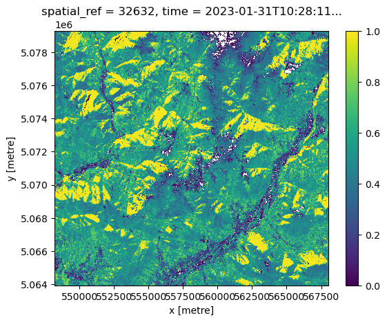
Use native projection to plot on geographical map#
proj = ccrs.epsg(ndvi.spatial_ref.values)

fig = plt.figure(1, figsize=[20, 10])

# We're using cartopy and are plotting in PlateCarree projection
# (see documentation on cartopy)
ax = plt.subplot(1, 1, 1, projection=proj)
ax.coastlines(resolution='10m')
ax.gridlines(draw_labels=True)

ndvi.plot(ax=ax, transform=proj, vmax=1, cmap="RdYlGn")

# One way to customize your title
plt.title("NDVI", fontsize=18)
Text(0.5, 1.0, 'NDVI')
Reproject to EPSG 4326#
import rioxarray
ndvi.rio.write_crs(ndvi.spatial_ref.values, inplace=True)
<xarray.DataArray (time: 1, y: 1535, x: 1982)> Size: 24MB
dask.array<truediv, shape=(1, 1535, 1982), dtype=float64, chunksize=(1, 1535, 1982), chunktype=numpy.ndarray>
Coordinates:
  * y            (y) float64 12kB 5.079e+06 5.079e+06 ... 5.064e+06 5.064e+06
  * x            (x) float64 16kB 5.482e+05 5.482e+05 ... 5.68e+05 5.68e+05
  * time         (time) datetime64[ns] 8B 2023-01-31T10:28:11.279000
spatial_ref int64 8B 0reprojected = ndvi.rio.reproject("EPSG:4326")
reprojected
<xarray.DataArray (time: 1, y: 1212, x: 2226)> Size: 22MB
array([[[1.79769313e+308, 1.79769313e+308, 1.79769313e+308, ...,
         1.79769313e+308, 1.79769313e+308, 1.79769313e+308],
        [1.79769313e+308, 1.79769313e+308, 1.79769313e+308, ...,
         1.79769313e+308, 1.79769313e+308, 1.79769313e+308],
        [1.79769313e+308, 1.79769313e+308, 1.79769313e+308, ...,
         1.79769313e+308, 1.79769313e+308, 1.79769313e+308],
        ...,
        [1.79769313e+308, 1.79769313e+308, 1.79769313e+308, ...,
         1.79769313e+308, 1.79769313e+308, 1.79769313e+308],
        [1.79769313e+308, 1.79769313e+308, 1.79769313e+308, ...,
         1.79769313e+308, 1.79769313e+308, 1.79769313e+308],
        [1.79769313e+308, 1.79769313e+308, 1.79769313e+308, ...,
         1.79769313e+308, 1.79769313e+308, 1.79769313e+308]]])
Coordinates:
  * x            (x) float64 18kB 9.62 9.62 9.62 9.62 ... 9.876 9.876 9.876
  * y            (y) float64 10kB 45.87 45.87 45.87 45.86 ... 45.73 45.73 45.73
  * time         (time) datetime64[ns] 8B 2023-01-31T10:28:11.279000
    spatial_ref  int64 8B 0
Attributes:
_FillValue: 1.7976931348623157e+308reprojected = reprojected.rename(x='lon', y='lat')
Save into geotiff#
reprojected.rio.to_raster("ndvi.tiff")
open geotiff with rioxarray#
ndvi = xr.open_dataset("ndvi.tiff", engine="rasterio")
ndvi
<xarray.Dataset> Size: 22MB
Dimensions:      (band: 1, x: 2226, y: 1212)
Coordinates:
  * band         (band) int64 8B 1
  * x            (x) float64 18kB 9.62 9.62 9.62 9.62 ... 9.876 9.876 9.876
  * y            (y) float64 10kB 45.87 45.87 45.87 45.86 ... 45.73 45.73 45.73
    spatial_ref  int64 8B ...
Data variables:
band_data (band, y, x) float64 22MB ...Visualize on a map#
fig = plt.figure(1, figsize=[20, 10])

# We're using cartopy and are plotting in PlateCarree projection
# (see documentation on cartopy)
ax = plt.subplot(1, 1, 1, projection=ccrs.PlateCarree())
ax.gridlines(draw_labels=True)
ax.add_feature(cfeature.LAND)
ax.add_feature(cfeature.OCEAN)
ax.add_feature(cfeature.COASTLINE)
ax.add_feature(cfeature.BORDERS, linestyle=':')
ax.add_feature(cfeature.LAKES, alpha=0.5)
ax.add_feature(cfeature.RIVERS)

ndvi.band_data.plot(ax=ax, transform=ccrs.PlateCarree(), vmax=1, cmap="RdYlGn")
#ax.set_extent([5.0, 13.0, 44, 50], crs=ccrs.PlateCarree()) # lon1 lon2 lat1 lat2
# One way to customize your title
plt.title("NDVI", fontsize=18)
Text(0.5, 1.0, 'NDVI')
/home/runner/micromamba/envs/geohack/lib/python3.12/site-packages/cartopy/io/__init__.py:241: DownloadWarning: Downloading: https://naturalearth.s3.amazonaws.com/10m_physical/ne_10m_land.zip
  warnings.warn(f'Downloading: {url}', DownloadWarning)
/home/runner/micromamba/envs/geohack/lib/python3.12/site-packages/cartopy/io/__init__.py:241: DownloadWarning: Downloading: https://naturalearth.s3.amazonaws.com/10m_physical/ne_10m_ocean.zip
  warnings.warn(f'Downloading: {url}', DownloadWarning)
/home/runner/micromamba/envs/geohack/lib/python3.12/site-packages/cartopy/io/__init__.py:241: DownloadWarning: Downloading: https://naturalearth.s3.amazonaws.com/10m_cultural/ne_10m_admin_0_boundary_lines_land.zip
  warnings.warn(f'Downloading: {url}', DownloadWarning)
/home/runner/micromamba/envs/geohack/lib/python3.12/site-packages/cartopy/io/__init__.py:241: DownloadWarning: Downloading: https://naturalearth.s3.amazonaws.com/10m_physical/ne_10m_lakes.zip
  warnings.warn(f'Downloading: {url}', DownloadWarning)
/home/runner/micromamba/envs/geohack/lib/python3.12/site-packages/cartopy/io/__init__.py:241: DownloadWarning: Downloading: https://naturalearth.s3.amazonaws.com/10m_physical/ne_10m_rivers_lake_centerlines.zip
  warnings.warn(f'Downloading: {url}', DownloadWarning)
- Access to remote dataset
- ARCO datasets
- STAC
References#
Basile Goussard, Ryan Abernathey, and Anne Fouilloux. The pangeo ecosystem. https://training.galaxyproject.org/training-material/topics/climate/tutorials/pangeo-notebook/slides.html#1, 2022 (accessed August 7, 2022).
Charles Stern, Ryan Abernathey, Joseph Hamman, Rachel Wegener, Chiara Lepore, Sean Harkins, and Alexander Merose. Pangeo forge: crowdsourcing analysis-ready, cloud optimized data production. Frontiers in Climate, 2022. URL: https://www.frontiersin.org/articles/10.3389/fclim.2021.782909, doi:10.3389/fclim.2021.782909.
Packages citation#
S. Hoyer and J. Hamman. Xarray: N-D labeled arrays and datasets in Python. Journal of Open Research Software, 2017. URL: https://doi.org/10.5334/jors.148, doi:10.5334/jors.148.
ODC Development Team. odc-stac: Load STAC items into xarray Datasets. 2024. URL: opendatacube/odc-stac.
pystac Development Team. pystac-client: Python client for searching STAC APIs. 2024. URL: stac-utils/pystac-client.
S3Fs Development Team. S3Fs. 2016. URL: fsspec/s3fs.